
Updated June 6, 2016 at 11:30 pm: The chart of the demand profile for the Eglinton East LRT has been updated by City Planning to correct an error in labelling where inbound and outblound values were reversed. The new chart has been placed into this post, and the link to the source pdf has been updated below.
Public consultation sessions are coming to an end on the “motherlode” of transit projects (as they were described earlier this year by Toronto’s Chief Planner, Jennifer Keesmaat). This process will soon bring a consolidated set of reports and recommendations for Council. So far, the presentations have been subdivided between various projects.
- May 25 Waterfront Reset Presentation
- May 31 Scarborough Subway & Eglinton East LRT Display Panels
- June 1 Smart Track & Relief Line Presentation
- June 1 Smart Track Display Panels
- June 1 Relief Line Station Fit Studies
- June 1 Relief Line Display Panels
- June 4 Eglinton West LRT Presentation
A major challenge for politicians, the media and the general public is to sort out all of these schemes and to understand how they all fit together. This is not just a question of how we will finance all of the projects, but of how each project and the choices made for it will affect everything else. Where typical studies in Toronto might have wrestled with whether a new line should go under street “A” or “B”, and where the stations might be located, today’s work requires understanding of how the network will evolve over time and how it will work as a whole in a few decades.
The process is complicated further by having municipal (City Planning & TTC) and provincial (Metrolinx) components, and the secretive nature of Metrolinx studies means that some vital information about its projects is not yet public. The Metrolinx reports are expected to appear on their Board’s agenda for June 28, and this implies public availability sometime in the preceding week.
The consolidated City reports should be available on June 21 when a briefing session is to occur at City Hall a week before the June 28 Executive Committee meeting.
Ridership Estimates
Still missing from this round are detailed reports on the demand modelling. A few numbers are cited as part of the presentations, but not a full examination of the networks and options that were modelled. What service levels are assumed on each of the routes especially in cases where they will compete for riders? How are “SmartTrack” and “GO/RER” riders in the same corridor differentiated from each other? How much contribution does each service make to “relief” at Bloor-Yonge? How many riders on any line are net gains to transit, and how many are shifted from other routes?
We have already seem demand projections rise and fall for the Scarborough Subway, and we are still owed an explanation of the high projected demand that was used to justify a switch from LRT to subway technology in the first place. Was this simply a professional error, or a politically motivated con job? Can we trust the new numbers any more than the old?
The issues before Council involve not just one line, but a large network with planning and construction commitments lasting decades. Cooking the figures to advance specific projects whether they be for SmartTrack, subway or LRT will set us on a path where, a decade or more out, we will ask “why did we build that”.
A related aspect of the model outputs will be not just the peak direction numbers for inbound trips, but the demand to nodes other than downtown. For example, how many riders will come to the Unilever development via the four separate routes (GO, SmartTrack, Relief Line, streetcar) that will converge on it and where will they originate? How many riders will travel outbound to the Scarborough Town Centre which, in theory, is poised to become a major job centre? Will STC remain a heavily car-oriented precinct, or will it begin a shift to transit? The same questions apply to the Airport Corporate district and parts of the waterfront.
Where Is The End of the Line?
The updated ridership estimates for the Scarborough Subway reawakened debate about just how many riders are needed to justify this type of investment. Anticipated peak hour demand southbound from Scarborough Town Centre is comparable to existing subway terminals and so why shouldn’t Scarborough get a subway?
Ironically, the demand at any terminal could be portrayed as a negative if it is “too high”, as at Finch, because capacity would not be available downstream. Has subway planning been reduced to a “Goldilocks” question of getting the terminal demand “just right”?
The situation is more complex than this. If only the terminal ridership number is used, the subtleties of network behaviour are lost.
The basic question is not simply the magnitude of demand. Where does it come from – a single fairly dense area around the subway, or a more diffuse collection of origins – and where is it going? How important are feeder services and how much of the feeder network would a subway extension eliminate? What are the implications for travel time for the whole market, not just for the link replaced by the subway extension?
Subway terminals today are artificial nodes in that they exist as points where many feeder routes converge, not as destinations in their own right. Neither Kennedy nor STC stations exist primarily to serve local demand, especially Kennedy where planning policies throttled growth at the subway terminal lest it compete with STC.
The rationale behind an LRT network (and indeed behind the original LRT plan for Scarborough four decades ago) was that it was extensible at modest cost compared with a subway line and could provide better coverage. The projected peak demand on a Scarborough LRT was actually higher than the new subway projection, in part I suspect because the LRT line would have gone further into northeastern Scarborough.
The debate would then turn on just “what is LRT” and whether its service would be comparable to a subway network. For this line, the “LRT” would have been completely grade-separated with widely-spaced stations, and it would operate at near-subway speed constrained mainly by the effect of extra stations. Time lost to the transfer (much improved over the RT) at Kennedy would be balanced by gains for riders originating east of STC who still face a bus feeder trip under the current plan.
It is simply not practical to keep extending a subway forever because eventually the demand becomes too diffuse, and the money would be better spent on a different approach. For Scarborough, the transition was originally to be at Kennedy Station, but STC has become the new centre at which the transit network will aim.
The pitched battle between subway and LRT advocates prevents a discussion of alternatives, and my personal sense is that this debate is over. However, the fundamental planning issue that a subway must end somewhere and give over to a network of feeders, be they bus or LRT, remains a challenge on all of our subway corridors. The lure of building “just one more stop” is very strong.
SmartTrack: The Elephant in the Room
In all of the presentation materials, the most threadbare, the least informative, is the section dealing with SmartTrack. This is no surprise given that the original plan was little more than an election gimmick, but it has morphed into a central part of Mayor Tory’s program without benefit of many vital components.
The original cost estimate of $8 billion is little more than a back-of-the-envelope number derived simply by taking the total mileage and multiplying by a notional cost per kilometer. That was back before ST boosters were forced to admit that an “overground” alignment through Mount Dennis, let alone along Eglinton West, was not feasible. This $8 billion was divided three ways – city, province, feds – but Queen’s Park’s caveat was that theirs would be “in kind” through the expansion of GO infrastructure in their RER project. As for Ottawa’s money, we still do not know whether this would be part of Trudeau’s billions soon to flow to cities across the country, or if it will be treated separately, a leftover goodie from the Harper era.
- On the provincial front, the funding is effectively capped at what is needed for RER, and if Toronto wants more capacity, they will have to pay for it, assuming it is even physically possible. A notable constraint is the limit on train and passenger movement through Union Station, but this is not the only potential bottleneck.
- If the federal money is taken from the general infrastructure stimulus pool, then SmartTrack will pre-empt spending on other projects that might otherwise have shared in Ottawa’s new funding.
- At the City level, the 1/3 share for SmartTrack is considerably more than the money to be raised through the Scarborough Subway tax. Candidate Tory claimed that this would come from “Tax Increment Financing”, a scheme that depends on the uplift in property values through transit-induced development. However, this mechanism is more appropriate for “brownfield” situations where a derelict neighbourhood is reborn, and the funding available from TIF will not be anywhere near the City’s share (even assuming that Queen’s Park passes enabling regulations to make TIF possible).
We don’t really know what “SmartTrack” will cost as a project because we have yet to learn the details of service it will provide and infrastructure it will require. Then there is the small matter of operating subsidies, and just what a “TTC fare” that SmartTrack would charge will really be when service begins. We still cannot get a straight answer out of the TTC on the effect that the Metrolinx “integrated fare structure” will have for subway riders next year, let alone for SmartTrack riders in 2021.
If the scope of SmartTrack, especially the more heroic parts of its original infrastructure needs, is scaled back, then the cost may well come in below $8 billion. But that cutback will also bring a reduction from the claimed service level, ridership and overall attractiveness of the line. What was touted as the one project to solve every transit woe by Tory’s campaign will instead be a marginal improvement on already-planned GO/RER service. All day ridership of 200,000 (the level claimed in Tory’s campaign literature) is simply not credible without very frequent service, and that is physically impossible without more infrastructure than GO plans to build.
Here are the service levels proposed in February 2016 (click to expand):
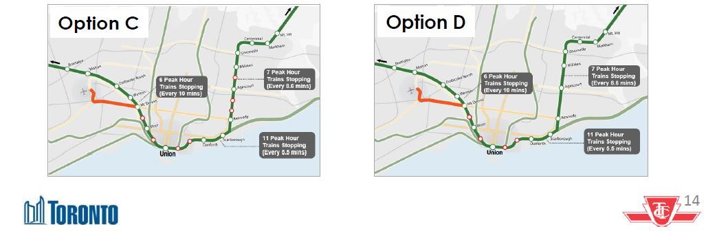
And here are the options as described in the June 2016 presentation, notably without explicit reference to service levels:
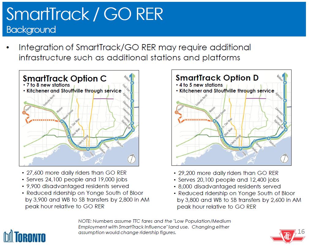
The marginal ridership contributed by SmartTrack over GO-RER is under 30,000, a huge reduction from the original 200,000. This has immense implications for the “business case analysis” of SmartTrack because there will be so many fewer riders than claimed during the election. We know from earlier reports that the LRT option on Eglinton actually improves ridership, and so some of the “SmartTrack” riders are really LRT riders.
City Planning still makes claims for SmartTrack that imply frequent service [p. 13]:
GO RER and SmartTrack will help relieve many of the transit network’s capacity limitations, which currently affect many parts of the City, including the subways serving Downtown, the SRT in Scarborough, streetcar routes east and west of the downtown and individual bus routes throughout the City.
It is intriguing that the effect is now a joint one between GO and ST, and that we are still worried about relief of SRT demand even though it is to be replaced by a much higher capacity subway. As for the streetcar routes, there are limited points of contact, and the attractiveness of ST would depend on a fast, convenient transfer connection.
If SmartTrack ends up providing only four trains per hour (a 15′ headway), this will be a far cry from the frequent “subway-like” service claimed during the election. Demand modelling already run for the City shows that very frequent service is needed for SmartTrack to attract riders and have the scale of benefits claimed for it. The disparity between those claims and the likely implementation has not stopped SmartTrack from triggering a gerrymander of other transit plans.
In Scarborough, the absence of a subway station at Lawrence East is explained away by the presence of a SmartTrack station where the RT now stops. However, with a train every fifteen minutes, riders may long for the day when their major complaint was the inconvenient transfer from RT to subway at Kennedy Station. Oddly enough, Lawrence East ST station was not included in one of the two configurations proposed earlier in 2016, but it has reappeared as a necessary adjunct to the “one stop subway extension”.
Closer to downtown, the Relief Line was originally to sit entirely at Queen Street, nominally for technical reasons related to construction, but also no doubt so that it would not compete with Smart Track as a service to the Unilever site. Fortunately this design was rethought in the most recent round of consultation, and the Relief Line now serves Unilever as part of a transit hub.
An intriguing point in the recent SmartTrack presentation [p. 13] is that it now includes two components:
- 41km of track along 3 existing GO corridors between the planned Mount Dennis Station and Unionville Station in York Region by way of Union Station in Toronto, and
- The Eglinton West LRT , an 11km westerly extension of the Eglinton Crosstown LRT from Mount Dennis to the Mississauga Airport Corporate Centre and beyond to Toronto Pearson.
In other words, an LRT line, something originally dismissed by Tory as an unsuitable transit alternative, has not just replaced the western leg of SmartTrack but become part of the “SmartTrack” brand. We could end up paying for the Eglinton West line out of “SmartTrack” funding much as the Eglinton East line is to be built with redirected Scarborough Subway money.
Equally important is what SmartTrack will not do for riders on other GO Transit corridors. Riders within Toronto on the Milton, Barrie, Richmond Hill and Lake Shore corridors will face whatever GO’s fare structure will be, and will not have a City subsidy for a SmartTrack service, whatever that might mean. This has a spin-off effect on the design of local services parallel to these corridors. Why should only riders in the Weston and Stouffville corridors benefit?
SmartTrack is a scheme that changes every time it is presented to the public, and its role diminishes at every iteration. Even so, planners continue to pretend that it is a “real” proposal, and integrate it, to the degree possible, in their plans. A better approach would be to collapse the travel requirement ST represents into the overall plan rather than trying to maintain a separate brand and service. This would not please the Mayor, but it would be better planning.
For information on the February 2016 Metrolinx review of GO’s co-existence with Smart Track, please see How Will SmartTrack and GO/RER Co-exist?
Eglinton West LRT
The LRT line on Eglinton West already has an approved EA, but the project halted through a combination of Rob Ford’s anti-LRT stance, Metrolinx’ desire to build only the central part of the line east from Mount Dennis, and then John Tory’s ill-conceived scheme to run a heavy rail line on the surface of Eglinton outward from the Weston rail corridor with SmartTrack. That part of Tory’s plan came unglued fairly quickly when the professional planners told him what he could not stand to hear during the election campaign – the branch along Eglinton would be ruinously expensive and disruptive to the neighbourhoods in Mount Dennis.
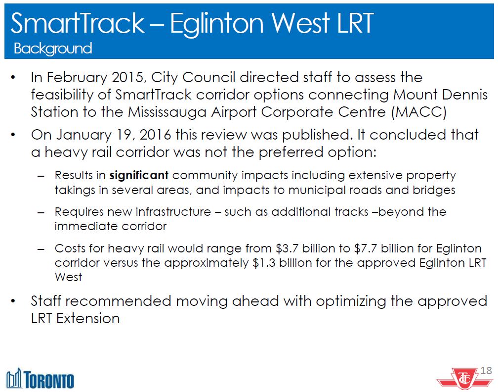
Tory’s campaign advisors, some of whom are professional transit planners, have a lot to answer for with their grossly misleading claims about this section of SmartTrack in particular.
One of the questions arising during public consultation has been why Eglinton West should be LRT rather than BRT (bus rapid transit). Both would consume road space, but BRT is perceived to be less intrusive, if only because so many implementations have been “BRT lite” with less priority and space dedicated to them than mmight otherwise be devoted to LRT.
Study of the BRT option concluded that the Renforth Gateway south of Pearson Airport would be the better place for an interchange between the Eglinton West LRT and the Mississauga services coming east via the busway.

If the connection were at Jane & Eglinton, this would be a classic “middle of nowhere” transit node that would add a transfer connection for anyone travelling east-west along the corridor. That would affect both riders from Etobicoke headed east to the Spadina subway, and riders heading west to the airport.
If the connection were at Mount Dennis Station, it would at least be at a future node, but at the cost of substantially greater bus traffic into that terminal. The extra transfer connection for most through trips would remain.
This is an example of the problem discussed above about the logical place for a line’s terminus. A major justification for SmartTrack was to serve the airport region, but imposing breaks in the network at other locations would work against that goal.
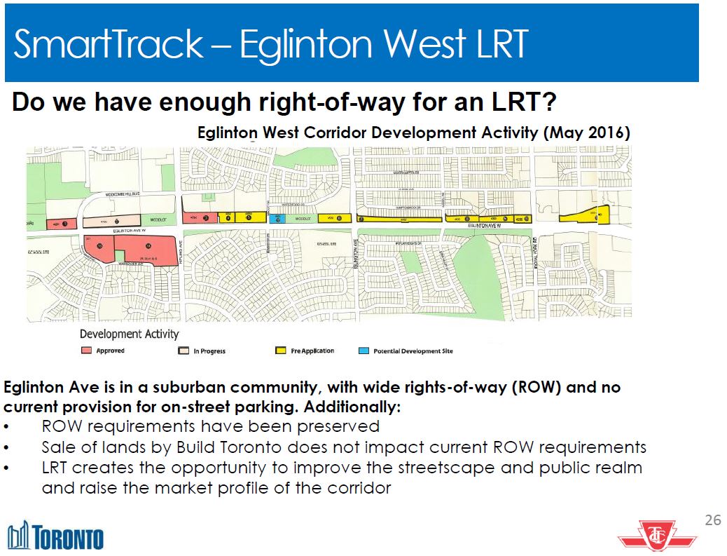
Still under study is the selective grade separation of the LRT at locations where right-of-way is limited or where traffic constraints would make a surface route difficult. These include the section immediately west of Mount Dennis Station (already planned to be underground), the 401/427/Hydro junction southeast of the airport, and river crossings enroute.
Land along the corridor was originally intended for the Richview Expressway, but this was never built. A great deal of the land has been sold (a fact that SmartTrack’s authors missed in their cursory review), but enough has been kept in public hands to allow construction of the LRT line.
The line is expected to carry 60-70,000 riders daily although until we see the detailed projections, it is unclear how many of these riders are bound for the core area and by what route (Weston rail corridor vs Spadina Subway), how many will make counterpeak trips to the airport area, and how many might use the line to reach Pearson Airport itself.
Technical work on the details of stop location, possible grade separations and route alignment will continue through into fall 2016 leading to a recommended configuration and a refresh of the Environmental Assessment for the project.
The Waterfront
In a recent article, I covered the Waterfront “Reset” study now underway. There are three major issues for potential waterfront schemes:
- How does any waterfront service relate to GO Transit’s RER network and/or to SmartTrack?
- What are the demand projections for waterfront lines and the capacity constraints of infrastructure such as Union Station?
- Why are potential costs treated as unaffordable when comparable if not larger sums are proposed for other parts of the network?
Toronto still has no sense of just what new services in the Waterfront might be expected to do, particularly west of downtown. There is no “SmartTrack” service planned for Lake Shore West, only the upgrades, such as they will be, for GO/RER. Added to that is GO’s concern that they will be capacity constrained in the corridor, and so the amount of room left for “local” passengers from inside the 416 will be limited.
This creates more pressure for an LRT solution to the demand problem in southern Etobicoke, notably with all of the new condo construction. With the schemes now on the table, a Waterfront West LRT would consume transfer capacity at Union Station, and could prove difficult to thread through the existing street system.
There is no demand projection yet for a WWLRT, and that demand will depend on both the alignment and stations for such a line, as well as the alternatives, if any, available such as the GO corridor.
As for the eastern waterfront, that project has been hung up for years because of the estimated cost of expanding capacity at Union Loop. More recently, schemes have appeared that would sever the link from Queens Quay to Union Station, and this could further hobble plans for LRT service to East Bay Front and the Port Lands. SmartTrack is not an option for these areas because the rail corridor is too far north and stations would be too far apart to serve these areas. However, that did not prevent ST advocates from claiming that their line would solve waterfront problems in the early days of various studies. Fortunately, that idea has fallen off the table.
The Relief Line
Since the February update on the Relief Line, Where Should A Relief Line GO?, City Planning has had second thoughts about the alignment. The February 2016 recommendation had been for a route south on Pape and then straight west on Queen to City Hall. Now the favoured route is via Pape to Eastern Avenue, then west to serve the Great Gulf development at the Unilever site, swinging back north to Queen between the Don River and Parliament Street.
The change in sentiment over the past few months is reflected in the scoring of alignment options.
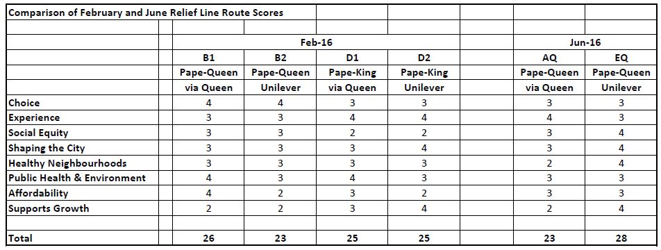
Back in February, the competition was between Broadview options (not shown), routes to downtown via Queen (the “B” options) and routes via King (the “D” options). By June, the nomenclature and option combinations had changed. I have shown only the Pape Avenue options here with the route via Queen (“AQ” equivalent to “B1”) and via Eastern (“EQ” equivalent to “B2”). The numeric values used here correspond to the “moon” values in the original reports (4 = full moon, 2 = half moon, etc).
Quite clearly, the ranking of the two alignments has changed, but the details behind the new scores have not yet been published. This is the sort of thing that makes one suspicious of such evaluations. Possibly new information (such as the importance of the Unilever site) has come to bear, but it shows how, had the definitive route been chosen only months ago, Council might have received the “wrong” recommendation.
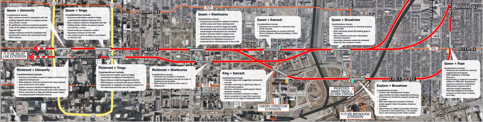
Details of the stations on either side of the Don River appear below.
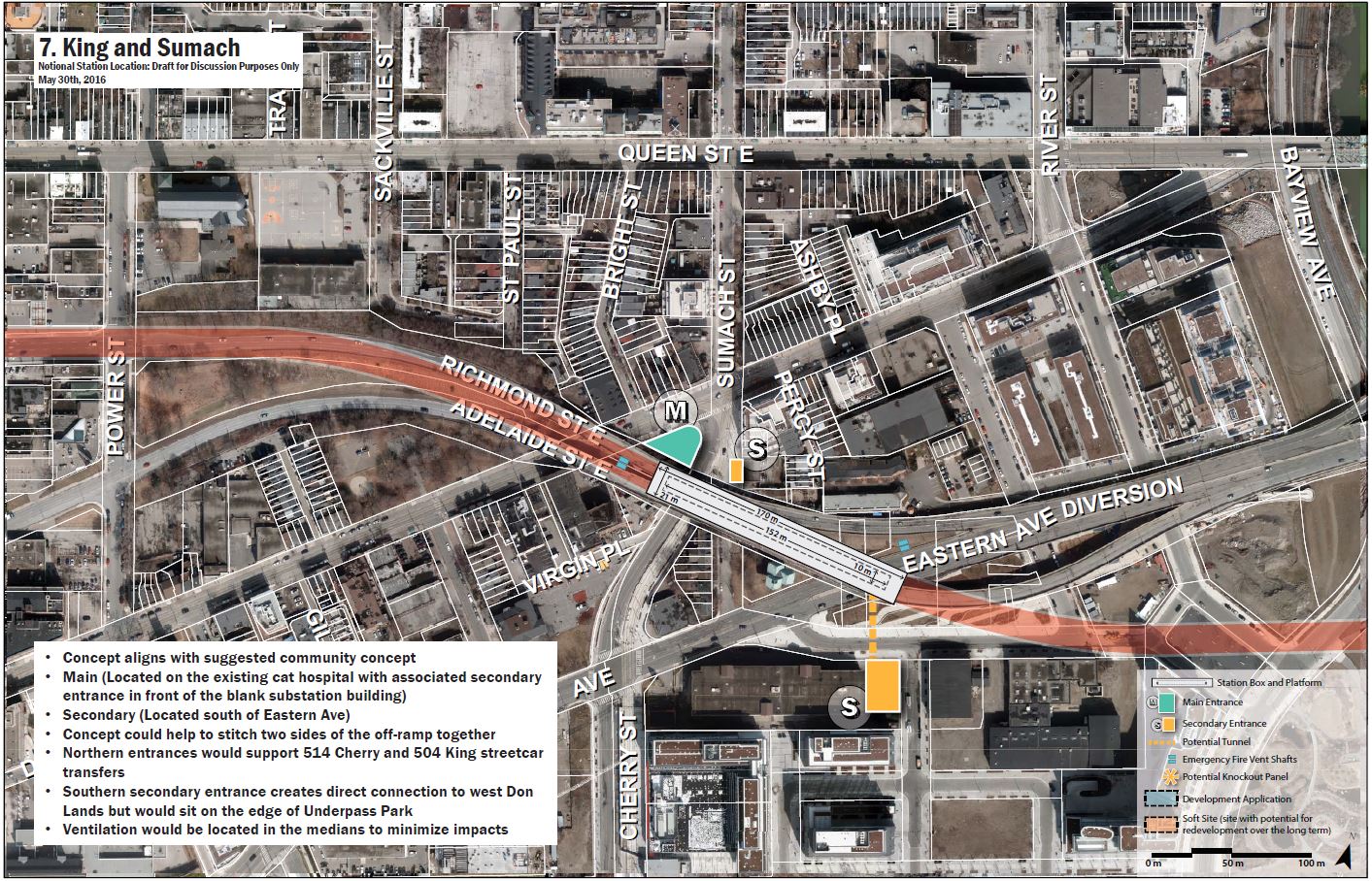
The proposed station at King and Sumach makes a much better connection with the transit system (King 504 east-west and Cherry 514 south) than a station at Queen would have. Nestling under the Richmond-Adelaide ramps from the DVP, the route threads its way through a tricky neighbourhood. The shift back north to Queen is not shown in the drawings, and the generic maps show the alignment passing directly under a large church at Queen and Power Streets. Some fine tuning is needed here.

A new station at what is now the foot of Broadview Avenue would be part of a major transit hub at the Unilever site to include SmartTrack, GO-RER and a Broadview streetcar connecting south into the Port Lands.
Another change in the revised design is that the single “City Hall” station has now become two separate stations linking to the existing Queen and Osgoode stations on the YUS. Which design survives is anyone’s guess. Staff at the presentation I attended indicated that these designs are only “for discussion”.
At Pape and Danforth, the Relief Line station would lie to the north of the Danforth subway. Links to the existing line would be built as west-to-north and south-to-west curves that would begin north of the station. Trains from Greenwood Yard would enter service westbound on Danforth and then turn north. They would leave service southbound turning west to the centre track at Chester Station, and then head east to Greenwood.
There is no discussion of the option of a tunnel under the rail corridor from Pape and Gerrard east to the south side of the subway yard.

Although “phase 1” of the Relief Line is the focus of current presentations, the recent announcement of $150 million for detailed study of the entire line (phase 2 north to Don Mills via Thorncliffe Park, and phase 3 west and north to Bloor/Dundas) means that the full line will get the thorough review it has needed for decades. For far too long, discussion of the RL began and ended with “we don’t need it and can’t afford it” with no examination of the benefits, offsets for expansion elsewhere, or place in the overall transit network.
Too often, transit proposals are dismissed without proper study because they don’t fit the political imperatives of the day. Now, however, both the crisis in downtown subway capacity and the desire for a subway extension to Richmond Hill have revived interest in the Relief Line as a line that will be more than a Pape-to-downtown offload for peak traffic.
Originally, SmartTrack advocates claimed that a Relief Line was superfluous because ST would provide all the “relief” that was needed, and Mayor Tory held to this position into late 2015.The service levels SmartTrack will offer, however, do not provide the sort of relief people really want to see as the numbers in the ST/GO/RER charts above show.
Now his position has changed, and he now accepts, indeed urges the importance of both schemes with SmartTrack providing interim additional capacity by 2021, and the Relief Line adding more nearly a decade later. The challenge will be to get the northern extension underway as soon as possible, preferably while phase 1 is still under construction, so that the larger benefit of the Don Mills subway will be felt as early as possible.
Completely absent from the presentation is any discussion of the need to serve a new major GO station at Front & Spadina which was proposed as part of the Union Station Corridor Study, and is likely to be recommended in the forthcoming Metrolinx study of new GO stations. The idea that the Relief Line would swing southwest, somehow, to serve this new station has completely fallen off of the map. (It would have been an easier connection with a King/Wellington RL alignment, but that was discarded in the February round of reviews where the option was not even part of the evaluation criteria.)
It is not yet clear how Metrolinx will provide distribution for passengers from the new terminal through the downtown area.
Scarborough Subway Extension
The Scarborough Subway has been under study for a few years with both the configuration and rationale changing along the way. The original scheme was a line from Kennedy Station through the Scarborough Town Centre and north to Sheppard where it would connect with a future east-west line (of indeterminate character). An original list of nine possible corridors was whittled down to three (Midland, McCowan and Bellamy), and of these, the McCowan corridor was selected because:
- It was furthest from the SmartTrack service in the Stouffville rail corridor and thence least likely to duplicate service and cannibalize ridership.
- A Lawrence/McCowan location for a station was the best among the north-south routes.
- The cost of this route was the lowest.
Since then, the scheme has lost both its Sheppard and Lawrence East stops, and the Eglinton East LRT from Kennedy to University of Toronto Scarborough Campus has, like its western cousin, reappeared on the transit maps. Although there will likely be a SmartTrack station at Lawrence (the site of the current Lawrence East RT station), it will not directly serve the hospital at McCowan as the subway would.
Construction is planned to be by a single deep bore tunnel south from Ellesmere and west to Kennedy Station, but by cut-and-cover in the station area within the STC. This has triggered considerable debate about the effect of the launch site for the bore (a structure similar to what we already have on Eglinton at Black Creek and at Brentcliffe).
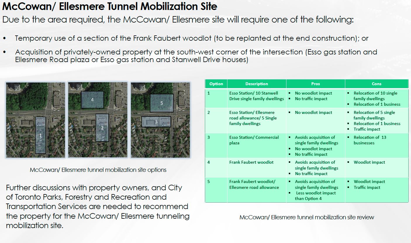
The tradeoff is between the acquisition of commercial or residential property, or the cutting of a substantial chunk of the Frank Faubert woodlot. Which of these wins out remains to be seen, but my own preference is to stay within the commercial property which can be redeveloped after subway construction is completed, but there is no “perfect” solution unless the launch site were completely removed from this intersection. Where else it might go is a challenging question, and the presentation gives no indication of whether other locations were considered.
Ridership projections for the line have anticipated criticism that there are not “enough” riders to justify a subway.
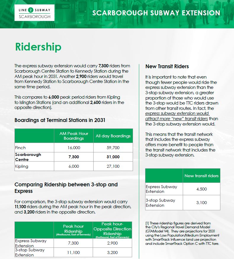
The pretzel-like shape into which planners have been twisted is amusing, but it is also a sad commentary on the political context of the debate.
There is no problem per se with the subway only having 7,300 riders at STC inbound in the peak hour, and this is certainly in the same range as other subway terminals (not to mention better than projections for the Vaughan extension). The real question, as discussed earlier, is whether STC is the appropriate location for the subway-to-surface transition in the network.
However, a clearly well-cooked projection of 14,000 riders was used to “justify” the shift from the original LRT plan to subway. Some of these modelled riders will now be on the SmartTrack service, and some may never have existed. We do know that some of the original “demand” came from Markham with commuters feeding south into the Sheppard terminal much as York Region riders now feed into Finch.
In a particularly convoluted argument, the presentation claims that although peak period ridership for the 1-stop line will be only two thirds of the 3-stop version, this is somehow “better” because the express line will attract more new riders. What is unclear is whether those riders might otherwise have been attracted to SmartTrack or GO rather than to the express subway as demand models are notoriously sensitive to travel time in making trip assignments.
In January 2016, Toronto’s Executive Committee passed a motion to “support the development of Scarborough Centre as a vibrant urban node”, whatever that may mean. In fact a single subway station might be less successful than a multi-stop LRT passing east-west through the STC planning precinct (much larger than the mall and civic centre), but this detail is conveniently ignored because the LRT option is no longer on the table.
Scarborough politicians hope that the subway will stimulate a long desired level of development in the STC precinct. Toronto’s experience at other terminals suggests that there will be a long wait for anything other than high density residential buildings made attractive by a quick access to downtown. The basic problem is that many people who would work near subway terminals do not live in the subway’s catchment area and therefore would not use the subway to reach their destination.
If the evaluation criteria are reduced to considering only one goal, a subway to STC, rather than the overall network, then the larger decision has already been made just as with the proposed Richmond Hill extension of the Yonge line. It is ironic that if SmartTrack actually were built as originally advertised, and especially if this service existed on both the Stouffville and Lake Shore corridors, the demand now funneled through STC and Kennedy would shift to these corridors. That demand would be overwhelmingly oriented to the core area because there is no “there” around the rail corridors which serve primarily old industrial zones.
Eglinton East LRT
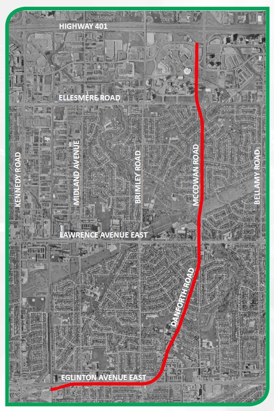
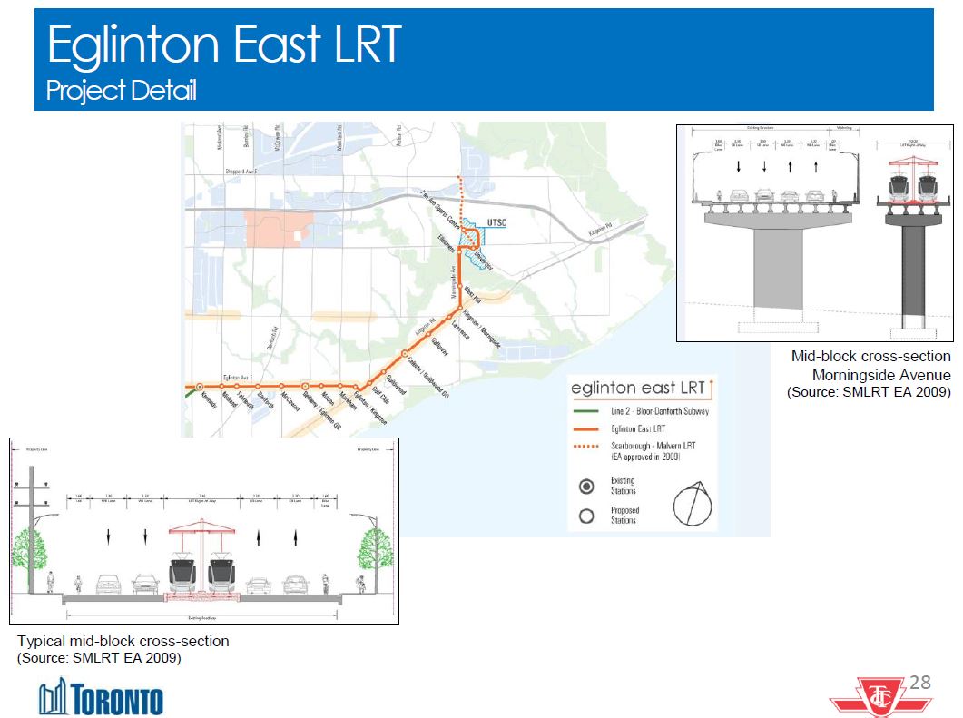
The Eglinton East LRT will run from an underground loop at Kennedy Station, surfacing on Eglinton and then going east via Eglinton, Kingston Road and Morningside to the University of Toronto Scarborough Campus. On Morningside, the line will run on its own structure over the Rouge River and then loop through UTSC looping ending, initially, beside the Pan Am Aquatic Centre.
At this point, it is unclear how the approach to Kennedy Station will interleave with the SSE itself and with the revised Crosstown LRT station design.
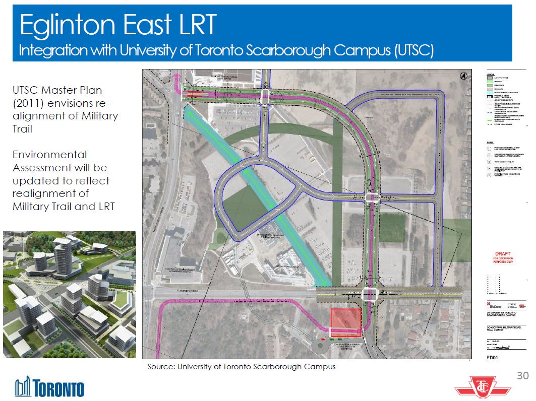
Within the campus, there are plans to realign Military Trail to follow the perimeter rather than crossing diagonally through the site.
Revised June 6, 2016 at 11:30 pm to include an updated version of the demand chart from City Planning.
The projected demand is 43,400 all day riders by 2041. During the AM peak, the majority is inbound to Kennedy by a wide margin. UTSC is a major destination, but the outbound peak may not co-incide with the commuting peak inbound. This is a more general problem for academic institutions like universities whose hours and locations do not fit the standard commuting pattern, but whose students are more transit dependent than the average population.
The nature of demand to UTCS bears further investigation once the detailed demand projections have been published.


Additional context from a discussion at Riverdale Collegiate with staff regarding the downtown station split into Queen and Osgoode: the staffer I spoke with made it clear that the City Hall station was seen as self-serving, and that the walk from there to either Yonge or University was seen as too far.
I suspect that staff maps that didn’t show PATH connections or station boxes (at the previous round) contributed to this. People don’t realize they are already halfway to X when they ride at the other end of the train. (assuming appropriate exit points of course)
Building two stations, and forcing trains to travel more slowly between them, seems ludicrous to me. I remain hopeful (but not optimistic) that the city will “discover” a reason they must build the single station, with heavily-promoted new PATH connections.
LikeLike
The downtown relief line only makes sense if it is built further north. It needs to at a bare minimum go as far north as Eglinton in phase 1. It is practically not worth building if it does not go as far north as Eglinton because it will have low ridership and do little to relieve the existing subway system. Also, I think that it would make sense to make this line incompatible with the existing subway system so that it can be automated, possibly have trains longer than 6 cars, have platform screen doors, and use off-the-shelf components, similar to the Canada Line in Vancouver for example. This would require that the new line have its own yard (which a longer DRL needs anyway) and is only possible with a longer initial phase 1.
Steve: Actually the new yard will come at the west end of the BD line thereby freeing up capacity at Greenwood, and giving a better spread to operations across the city.
The Scarborough Subway needs to have Lawrence East station re-added. It is very unusual to have a subway line cross a major bus route and not stop. I think it is needed however because the SRT is overcrowded, the transfer at Kennedy is inconvenient, and it will save riders a significant amount of time. It takes far too long to get from the west to Scarborough Centre right now and it usually is much faster to drive even in rush hour. I don’t think that the projected ridership of the Scarborough Subway is that low; regardless of what projections you believe, Scarborough Centre will probably have ridership higher than every subway terminal except Finch. This is not surprising since Kennedy, Kipling and Downsview have less development around them than Scarborough Centre, while Finch is very densely populated. Terminal stations on the subway (except Finch) tend not to be very busy because ridership is much higher near downtown than at the ends of the line.
LikeLike
Regarding the connection of the Relief Line to B-D/Greenwood Yards: so the south-east corner of Danforth and Pape would be spared demolition. I was wondering if they were considering a connection down at the rail corridor, but a connection north of Danforth seems like a good idea.
LikeLike
I am very much of the mind that transit is like any other network, the value of a rapid transit network increases very quickly (exponentially) with the number of nodes connected. I believe that there is too little value placed on connecting more locations, and too much placed on the import of the size of that connection as opposed to the time reliability and relative speed of that connection. Saving a total of 5 minutes in a commute is likely less important, than making it certain. Also in terms of encouraging the general habit of transit, broadening the scope of rapid transit needs take a larger role, than the current subway focus.
In this vein, the current idea of ST needs to be dropped in favor of a broader rapid transit network. This network can also be used to deliver riders to fewer, more meaningful RER stations. If we push the new Scarborough focus of transit, to the STC, there still needs to be a rapid transit connection to the north and east to link it. There also needs to be a time reliable transit option to connect from there to the NYCC, that is not a bus that can get caught in traffic. This focus on network, and making a point of connecting the various nodes of the city, needs to be the new focus of any plan. There needs to be access to lower cost areas as well, to shift growth to transit oriented growth. That means we need to focus, on creating an extensive, lighter network, and stop with the obsession with subway to beyond.
LikeLike
P.S. This sort of broader network, connecting the STC with a “hinterland” as well as the subway – would likely make it a much more attractive business center. The same being true of the NYCC. If these are further connected to each other and the airport, as well as each to the core, the value of being at one of these and being able to attract employees, from a lower cost (both in dollars and time), transit connected area beyond becomes much more attractive.
Steve: Yes, there is a big problem that suburban centres draw from a 360-degree range of residential areas around them, but a single rapid transit line terminating at a centre only serves at best 1/4 of the catchment area.
LikeLike
Any idea why the Queen/Yonge stop on the DRL is on the west side of Yonge? Wouldn’t it make more sense for service and spacing if it were on the east side? This stop would better serve the hospital and potential redevelopment around Church St, and would encourage those headed to City Hall to get off at Osgoode and take the Path, which might help reduce transfer traffic at Yonge, which I have to imagine would be higher.
Steve: I suspect that the idea is mainly to simplify a PATH connection to City Hall from Yonge.
LikeLike
As a review of basic principles, I would like to know the ridership numbers for the Eglinton Crosstown LRT in Scarborough – Victoria Park to Kennedy. Both Metrolinx and city planning concede that the LRT will reduce vehicular traffic on Eglinton because it will be reduced to 4 lanes. The proof was in Aug-Nov 2014, when watermain refurbishment, between Midland and Brimley, dramatically congested Lawrence and St. Clair. The offset of reducing vehicular capacity is improved public transit. How significant is that ridership improvement? With Lawrence, Eglinton and St. Clair congested there is a serious threat to be able to promise economic development. The LRT extension justification was for economic development. (The cause for increased circulation is the dramatic increase in population density of Markham, a car oriented society that has overrun Scarborough)
Last September Metrolinx announced a surplus of $2 billion on the Crosstown LRT project. This was a nudge to Toronto, to amend the 2009 plan to put the LRT underground in Scarborough. City planners declined the offer and contracts were signed for the Scarborough surface route this spring.
The 2009 LRT plans have the portal of the LRT emerging from Kennedy station just west of Midland. As the LRT platform is 2 levels below grade at Kennedy station, this portal location will be revised.
City planners truly misunderstand Lawrence. They were unaware that the bus headway for Lawrence is well under 2 minutes. I overheard at the information booths, that the SmartTrack (east) headway was 8.6 minutes up from a Metrolinx statement of 7.5 minutes in the spring. With the SRT removed this is still inadequate rapid transit service at Lawrence. The catchment of buses using Lawrence will be seriously degraded after the billions of dollars spent.
Steve: I agree with you about Lawrence, and about the general overselling of the attractiveness of SmartTrack service. As for Eglinton, I have heard some at Metrolinx say that they should just widen the road, and the issue of congestion would vanish.
LikeLike
It seems so sad that while planning staff have finally realized that moving the Don crossing south to Eastern Ave. is much preferable to Queen, they insist on dragging the subway back north to Queen when it would be so easy to continue routing it along Eastern/Front/Wellington, where the track, at least, could be built completely within the road allowance.
Anyone who has tried to catch the King car eastbound from Yonge in the morning can tell you that there is vastly more demand here than at Queen – largely George Brown students headed to one of 4 locations between George St. and Ontario St. A RL stop at Front & Sherbourne would see heavy counter-peak traffic on day one on that basis alone… And that doesn’t even consider all the other points along King and Front that could also be demand generators like existing and new office buildings (planned/being constructed at the Toronto Sun building, the former Sun TV building and others), the market district, the distillery district… Whereas Queen has what, Moss Park?
LikeLike
Do they have estimated/guesstimate ridership numbers for each of the proposed stations on the Relief Line (Phase one)? I especially would like to see how they compare with the full set of Scarborough Subway stations (IE. Unilever vs. Ellesmere) and the single station they are leaning to.
Steve: They almost certainly have this info, but have not yet published it.
LikeLike
I just hope that Mississauga is not forced to pay for Toronto’s LRT to the airport just because the airport is in Mississauga for it is called Toronto Pearson International Airport and NOT Mississauga Pearson International Airport. It is outrageous that millions of visitors come and leave Canada via Mississauga every year most of whom leave without ever hearing of Mississauga and so it is in Toronto that they spend their billions of dollars every year and NOT Mississauga as most have never even heard of it. It is outrageous that both the airport and the university in Mississauga are named after Toronto.
Steve: Well, the original name was “Malton Airport” and it then became “Toronto International” when Mississauga was still a collection of small towns. As for the university, it is a branch campus of UofT. Get used to it.
As for funding for the airport link, there has never been any suggestion that Mississauga should contribute to this considering that it will serve a (mainly) Toronto rapid transit line.
While we’re on the subject of who pays for what, I am not looking forward to Toronto carrying the operating cost of the Vaughan extension which will add substantially to the TTC’s operating deficit, but for which York Region will pay bupkis.
LikeLike
I still think provisions for future stations at Brimley/Eglinton/Danforth and at Lawrence & McCowan should be made as part of the SSE.
Steve: I agree.
LikeLike
As Steve mentioned the PATH connection may be a factor however I suspect the fact that St Mike’s is on the east side may have something to do with it. A DRL stop on Queen just east of Yonge would likely end up at Church St given the hospital and Metropolitan United Church there. At Church you have a parking lot.
It would be nice to have a station east of Yonge but I doubt a major hospital like St Mike’s would appreciate all the construction.
LikeLike
15 minutes headway on the Smart Track is not that bad. The trip time to Union is much faster than the subway since the subway trains make many more stops along the way. The commuter trains in Sapporo and Fukuoka operate with similar frequencies. Toronto is not Tokyo and trains will not run every 120 seconds.
Station configuration is a big issue in Toronto. Terminal stations like Finch were poorly conceived. There are no destinations near that station except the office towers. Who will say, “let’s head over to Finch Station for some fine dinning?” Terminal stations must have retail and restaurants so that people are not just using the station to transfer to another mode. Destinations can be created. Just think about how many Loblaws or No Frills are easily accessible from a subway station in Toronto. Supermarkets generate a lot of traffic, but our stations are not close to them.
LikeLike
If the subway is going to STC, leaving out a Lawrence station seems a foolish way to save a small percentage of the overall cost. I’m fairly sure that the station would get a fair bit of traffic from hospital and frequent buses. A crude political sop, nothing less.
LikeLike
Benny Cheung said 15 minutes headway on the Smart Track is not that bad.
I have to say if you consider the passenger build up at the Lawrence East SmartTrack station with buses coming in every 1.5 minutes (from east and west), the already filled SmartTrack train could not accommodate them at every 15 minutes. There are more apartment buildings being built at Birchmount and Lawrence.
LikeLike
Then how did they build the University line?
LikeLike
The planners at the meetings seem to be far more obsessed with Ryerson University than George Brown and their line of buildings stretching all the way to the Distillery and the new student residence located there. Dare I say college students are being treated like second class citizens vis-a-vis their university counterparts?
You are quite correct there is very strong bi-directional demand along King Street East; east from Yonge to GBC (as you’ve said) and the office buildings around Ontario Street and from the Danforth subway to the same destinations. With the current proposed station sites, the transfer situation, and walking distances, I foresee a large portion of George Brown traffic not bothering with the subway line at all which would be a gross indictment of the choices planners have made.
Also correct, there are no demand generators on Queen until you are in the core. Virtually all customers that board on Queen Street East do not alight until they are in the core starting from Victoria (St. Mike’s). Queen Street East passenger flows are predominantly core oriented peak direction.
The chief planner has made comments on Twitter about finishing up phase 1 before looking at phase 2 and 3. There are obvious problems with this approach of looking at later phases in isolation from the first phase, particularly when it comes to the east to west alignment through downtown.
Steve: Here is the Twitter exchange:
That does not sound like a long deferral to me.
LikeLike
There are many places in which a subway station or line was built near a major hospital, noise a block away is still noise, it really does make more sense for the Queen station to be on the east side. Queen Stn already has many destinations with high demand including the Eaton Centre, while Osgoode has comparatively fewer. Therefore it would be better to encourage traffic to City Hall/the York St area to use Osgoode (we could even rename the station City Hall-Osgoode), and let Queen handle its own traffic in addition to the transfer traffic.
Also @Benny, ironically Finch Station is actually the perfect counterexample to your point: There is a large area of (mainly Korean, Persian, and Chinese) restaurants and businesses in that area, and it is very busy and crowded at nighttime and a destination in itself. (And there is also a Loblaws that is connected directly to the subway just one station further at North York Centre.)
LikeLike
Once Smart Track and the Regional Express have been built, all the traffic heading to Lawrence East Station will be spread out over two directions. Not everyone getting off the 54 bus will board a southbound train to Union. Some will take a northbound train to Markham and beyond. The most important is to build it. Once it is built, capacity can be optimized by buying EMUs.
The restaurants along Yonge and Finch serve mainly a local demand. Aside from Kinka at Sheppard, there are no authentic izakaya and ramen in that area. In a terminal station like Finch, there are no stores within walking distance like a department store or a supermarket. Some one transferring from Viva Blue to the GO Bus 19 will not waste a token to go to Loblaws at North York Center Station. If there were Loblaws and The Bay on top of Finch Station, one can spend some time shopping before boarding the GO. This is one of the arguments that motorists use all the time. Transit is not as good as a car in going to and from work and then picking up groceries or dry cleaning along the way.
Steve: I should put in a pitch here for time-based transfers that would allow stopovers without a fare penalty.
LikeLike
I agree with both, the fewer stations makes for a faster trip, and the 15 minutes, is not bad. However, that begs the question why ST, this is what RER was to provide, and what do we gain, by pretending it is a new plan, that requires massive change.
The thing is that Lawrence East in the long term, in my mind at least should be considered as a contender for LRT. It could be anchored at the one end by a station on the DRL, and cross and connect to the BDL, or better, a higher service level LRT that would serve the route. We should be looking to have higher not lower service levels, for Lawrence connections. The LRT would have provide enough capacity, at a much lower cost, and provided considerably more flexibility going forward. Longer term, if Toronto, is to continue to grow, without sprawling to beyond, the idea of an Avenues plan, needs to be understood, and that means supporting a higher level of density, and a less auto oriented development to support it. Again, the value of a network grows exponential with the connections it makes, and well, keeping open the idea of a Lawrence continuing redevelopment, with transit and pedestrian oriented shopping, and residences, should be part of a long term plan. Cutting off the possibility, means leaving a lot of area ripe for redevelopment otherwise, in a form that results in seas of parking.
LikeLike
I believe all these things are possible with the existing subway technology. And the advantage of being able to share yards almost certainly off-sets the advantage to being able to use “off-the-shelf” parts.
Steve, do you know if they’re currently planning for a connection to the YUS line at Yonge or University?
Steve: No. The connection will be in the east end to the Danforth line. There is no room physically to build curves linking to the YUS.
Keep in mind that temporary diversions are very different from permanent changes. If that congestion was permanent, many of those drivers would start taking the LRT or other transit, or they would simply find ways to drive less.
I believe there should be a Lawrence East station on the SSE. That said, I don’t think it’s as bad as you fear. Even in a worst case scenario (for people trying to fit on a train) in which Smart Track runs only every 15 minutes at TTC fares and Lawrence is the fifth stop on the line, the trains and platforms will be much bigger than current SRT trains and platforms. And in reality, the frequency of trains is likely to be better than 10 minutes, and it’s unlikely that there are four stops ahead of Lawrence (if nothing else, I don’t see any way Ellesmere gets built).
Also, some people who currently take the bus to Lawrence East will find it more efficient to take the Crosstown East to Kennedy, or head to Scarborough Town Centre or Don Mills Crosstown station instead, especially if Smart Track is not a TTC fare. Many people won’t keep going to Lawrence East if they won’t fit on a train (note: I’m not arguing this is good planning).
Wait, are you seriously making the case that if they called it Mississauga International Airport, the tourists would be flooding into Celebration Square? Is your theory that when people do their vacation planning, they’d make a special effort to check out the area around the airport if only they knew what it was called?
How many people, do you suppose, while planning their trip to New York City, choose to spend their money in Newark (beyond the fare for the swiftest taxi across the border they can find)?
Also, the airport is in both Toronto and Mississauga. So if you’re going to make a case for a ridiculous name change, it should at least be “Toronto-Mississauga Pearson International Airport.”
LikeLike
I do hope, Steve, that you realise that modern subway tunnelling can occur with disturbing activities on the surface – as many projects around the world including Crossrail (London) have proved. It’s the stations that make a big mess on the surface!
Steve: Yes, that is true, but until I see a vertical alignment plan, it’s a concern.
I’ve seen a worrying amount of hearsay across the internet about the awful/terrifying/adverse construction impacts of the Relief Line this week – noise, cut and cover, sinkholes etc. To my eyes, many Torontonians do not realise that subway construction in urban centres has moved on since the last time a subway line was constructed downtown in the 1960s.
Better education by planning dept required I think. This may be similar to the ‘What does an LRT actually look like’ problem…
Steve: Torontonians are getting a good sense of what subway construction looks like on Eglinton Avenue.
==
On a lighter note, may I suggest a better name than Relief Line for everyone’s consideration? How about the “Rocket Line” in a matching TTC Rocket Red line colour?
Steve: I have always held that it should be the Don Mills Subway so that it is clear what area it is intended to serve.
LikeLike
To Jeff Pearson: when they called the airport “Toronto International Airport” it was in Toronto Township. So there’s that.
Are residents of Hillingdon, England miffed by all the air passengers flying into London Heathrow Airport? Are residents of Haarlemmermeer put off when people fly into Amsterdam Airport Schiphol?
LikeLike
With the plan being to finalize everything for phase 1 to start the TPAP by fall 2016, my worry is that we’ll have already closed a lot of doors before knowing where or what we want with the other phases.
Phase 2 to Eglinton or beyond is fairly obvious: there are only so many paths you can take.
Phase 3 is a lot more murky. If as I suspect it doesn’t get built for a long time, things will get a lot more complicated if the line needs to veer southwest from University because of all of the high density residential and commercial development happening on King and Wellington.
B1/AQ had an estimated cost of $3.7 billion in February and scored 4/4 on affordability. B2/EQ had an estimated cost of $4.1 billion in February and scored 2/4 on affordability. In the new May/June scoring they both score 3/4. Obviously they have new information they’re not sharing with the public.
The presentation boards for the current round of meetings also proudly trumpets B2/EQ alignment as clearly generating the highest ridership in 2031 and 2041. This is only true in a very narrow context.
LikeLike
I’d say we’ve moved from a cat’s cradle to a rat’s nest.
The DRL alignment is being influenced by a proposed SmartTrack Station that probably will be on the other side of the river. A single island platform is shown, but the main issue is that changing track spacing on a curve takes extra space.
Actually, part of the magic of SmartTrack financing was that Toronto only paid the municipal portion for the parts within Toronto.
Steve: I don’t count SmartTrack because it is a fantasy transit plan.
So Toronto Harbour Commission bought the land and built the airport in 1939. The City of Toronto sold the airport to Transport Canada in 1958, and it was TC that renamed the airport to Toronto International in 1960. However, if you were more aware of Mississauga history, it was originally Toronto Township in Peel County and founded in 1806, while the Town of York didn’t become the City of Toronto until 1834. Moreover, Toronto Township was a municipality until 1967, so the “Toronto” in “Toronto International Airport” referred to Mississauga before Mississauga changed their name.
I guess we need to rename a lot of airports that are robbing local tourism:
London Gatwick Airport to Crawley Gatwick;
Paris Charles de Gaulle Airport to Roissy-en-France Charles de Gaulle;
Istanbul Atatürk Airport to Yeşilköy Atatürk;
Amsterdam Schiphol Airport to Haarlemmermeer Schiphol;
San Francisco International Airport to San Mateo International;
Kuala Lumpur International Airport to Sepang International Airport;
Munich Airport to Freising Airport.
Yes, that’s why there is so much trouble getting a third runway at Heathrow. However, Hillingdon is a borough of Greater London, so it would be like Etobicoke objecting to the Toronto name.
LikeLike
Further discussion of the Lawrence SmartTrack station.
There is latent demand for the Lawrence subway station. Part of the north south bus traffic to Kennedy is due to the awkward SRT set-up (spastic service and length of transfer at Kennedy Station). The density of Lawrence/Kingston Road/Morningside generates high volumes (86, 116 buses). It would be much quicker with a Lawrence subway stop. I was trying to get the 116 to domicile at the Lawrence station instead of Kennedy. It has one of the highest number of buses in the TTC.
The extended LRT can pick up Lawrence passengers, but it only takes them to the Kennedy station entailing another transfer to the subway (Yonge/Bloor crisis) or SmartTrack with the same service at Lawrence. STC may be a choice, but I suspect the STC terminal will be quite busy since there is no rapid transit north of the 401.
I’m all for EMU service. SmartTrack has challenges even with EMU’s. The switches in the Union Station Yard and narrow platforms in Union Station.
LikeLike
Which would not at all be a bad thing. The PATH from the Sheraton through to Queen subway station is one of the worst parts of the network. It’s congested and has four level changes, including an annoying down and up to pass under Bay Street.
Then there’s the fact The Bay treats the segment as any other part of the store, setting up displays in the already narrow isles. Don’t even get me started on the wandering shoppers paying no attention and standing in everyone’s way. I have to wonder if they are pressuring for a PATH bypass around their store to get rid of all the people passing through.
LikeLike
Since the line is going to be built for ATC operations, and the gap between stations in the two station plan is relatively small, I have to ask whether it would be worthwhile to consider both ideas at the same time. By that, I mean create a single station that would stretch between Queen and Osgoode stations with trains not stopping at the centre portion during low demand periods. (Yes, I am thinking along the lines of a certain CTA red line station.)
LikeLike
That’s not hard to figure out: It has the symbolism of a stop at City Hall.
LikeLike
Post Crosstown East (assuming it’s built as currently planned) I imagine the 116 dramatically changed, and it’s days of running to Kennedy are (hopefully) numbered. For passengers heading downtown from the Lawrence/Kingston/Morningside area (and parts east and slightly west), the Crosstown will likely be the better option either way.
Any of the Crosstown East, STC, Don Mills will have the exact same effect on the Yonge line as a Lawrence East SSE station. Which is to say, under basically any Scarborough plan, the DRL becomes even more critical. However, since a Lawrence East SSE station would likely siphon riders away from Smart Track, building it would actually be more detrimental to capacity on Yonge.
Also, we have the numbers for STC, and they definitely don’t say that it will be overwhelmed with traffic.
LikeLike
The project timelines for the Crosstown East and West seem too long — Jenniffer Keesmaat posted on twitter that the Crosstown East line could start construction within 3-4 years of council approval.
Why so long? Are they still going with that time wasting, excessively bureaucratic alternative financing and procurement P3 that Metrolinx and Infrastructure Ontario use? And is there a way to speed things up as Councillor Joe Mihevic was calling for? Such as the procurement method that the City was going to use back when they were planning to build the Transit City lines.
As I am sure many know, this kind of foot dragging will lead to the death of these lines, again.
Steve: Both Queen’s Park and Toronto want to push major construction on any new project off into the 2020s when the current constraints of balancing budgets and dealing with borrowing caps will, theoretically, be behind us. The problem is that by that time, the Visigoths may be in power again at Queen’s Park and who knows will have taken over City Hall.
LikeLike
This is speculation.
In an above comment, I refer to concern about vehicular congestion by reducing Eglinton and Kingston Road to 4 lanes. There could be economic consequences.
Steve: Maybe so, but the 116 will almost certainly vanish once the LRT line opens. Indeed this is supported by the email you sent privately to me listing the proposed changes in Scarborough bus routes post LRT, SSE and SmartTrack. You are fear-mongering to prop up your complaint about lost traffic lanes.
Totally agree that the SSE is detrimental to the Yonge/Bloor issue. I have personally spoken to the “subway politicians” and they deny a Yonge/Bloor issue.
I was referring to the bus routes that need to access the STC. The McCowan/Progress intersection is challenging. The flow of buses from north of the 401 into the STC will be quite the parade.
LikeLike
The station box for Queens Park Station is just NORTH of the hospitals, not underneath. They tunneled from St Patrick to Museum so they could go underneath and around the hospitals and Queens Park.
If you put a station on Queen just east of Yonge it would be UNDERNEATH both St Mikes and Metropolitan United church. I doubt one of the busiest hospitals in the city wants a subway with a direct exit into their OR or ER.
This is why I suggested it would need to go at Church Street.
LikeLike
Put this thing/subway under King.
LikeLike
Let us build the Scarborough subway and Eglinton East LRT all the way to UTSC before building the Scarborough LRT replacement for the SRT and extend the replacement all the way to Centennial College and/or Malvern. That way we will avoid the decade long chaos of replacing the SRT with gazillions of polluting diesel buses day in and day out for a decade.
Steve: It would not take a decade to replace the SRT with an LRT line, maybe less than three years (according to a now retired head of construction at Metrolinx) if the desire were there to do it quickly rather than threatening people with an endless shutdown.
LikeLike
It’s the Motherload of napkin plans. What a mess they’re making of the SSE. Either hurry up and clarify the surface route or add a stop on Lawrence stop and get on with it. Otherwise we’re headed for chaos once again next election.
Which is good for no one.
LikeLike
The restaurants along Yonge and Finch serve mainly a local demand. Aside from Kinka at Sheppard, there are no authentic izakaya and ramen in that area. In a terminal station like Finch, there are no stores within walking distance like a department store or a supermarket.
Nice to be in an era where development is deemed insufficient if it lacks authentic izakaya and ramen (what exactly is authentic ramen??). Of course, Yonge and Finch has had late-night Korean and “cool” fusion places like Krazy Wings (to say nothing of Korean dessert places and it goes on) for a long time. There is also a No Frills and a Shoppers well within “walking distance”, along with a Metro not that far away. In any case, grocery stores are intrinsically for “local demand” rather than “destinations”, so I’m not sure if your critique is meant to be serious. But if it is…
LikeLike
There is a Food Basics within walking distance. Canada Computers is there. Also present are a lot of Middle Eastern businesses. Sounds like a hub to me.
LikeLike
Supermarkets are not necessarily local in nature. For example, there are no Loblaws or Whole Foods in Scaborough and most of Etobicoke. If someone living in Scaborough wants to buy Blue Goose Organic Chicken, they would have to go to either North York, Markham or Pickering. A lot of people transit through Finch to get to work, if a supermarket or department store is built on top of the station, access will be much easier. It is hard to eat healthy in certain areas in the city.
Winter in Canada is pretty brutal. Having to walk outside for 10 minutes is brutal for most. This is why we have buildings that are directly connected to stations. The goal is to make transit use more comfortable and convenient. If station design can be optimized from the beginning, it will make transit much more attractive to the motor vehicle. Remember, the space inside a vehicle is climate controlled.
We already have climate controlled space for GO waiting areas (at Finch), why not take it one step further and build 300000 sq ft of retail space on top of it. People in transit can use it to do their shopping and eat on the way home. It will be a meeting space for different people. For example, Finch will be convenient for someone living in Pickering, Mississauga and Newmarket. It is only one GO bus away. If we have a have a restaurant zone on top of the station, it will just give people more choice and make it a destination.
LikeLike
Unless you are going to provide a direct climate-controlled connection between my house/apartment, I’m going to be subjected to the weather. The cold isn’t so bad as the wet. If you dress appropriately, it’s only around -25 that your eyelashes start to freeze. When it’s windy, pelting rain, and near zero, it’s hard to stay dry and warm. Of course, good station design is going to encourage usage, but a real destination rather than a temporary lay-over is preferable. This really gets into the underlying planning and transfer policies that limit the system.
What ‘GO waiting areas’ are you talking about? Finch Bus Terminal on Yonge? If so, it’s in the Finch Hydro Corridor, and HydroOne will not permit any new structures in their right-of-way.
Seriously? Not even fully grade-separate transit would be convenient to both people in Pickering and Mississauga. Even then, both are very car-orientated, so rather than paying the $13.94 roundtrip for a GO bus from SquareOne to Finch, why wouldn’t they just use Whole Foods, Walmart, or Rabba at SquareOne?
Don’t try to oversell your premise. Mixed modal stations are a good idea that most people would support on their own merits. However, there are many barriers to making it a reality.
LikeLike