
The TTC Board received an update from City and TTC staff on the status of major transit expansion plans in Toronto at its meeting of September 28. The presentation was largely delivered by Deputy City Manager John Livey with backup from Mitch Stambler, TTC’s Head of Service Planning. Also at the table, but notable for her silence, was the Toronto’s Chief Planner Jennifer Keesmaat. A contingent from Metrolinx, another agency studying transit expansion, was in the public gallery, but they did not participate in the presentation or discussion.
This session was a prologue for a report coming to Toronto’s Executive Committee on October 20, 2015, but a great deal of detail remains to be fleshed out. This proved frustrating for the Board members on two counts. First, the lack of detail prevented the TTC from making informed comment on the plans, and second, the process itself has largely bypassed the TTC Board and concentrated work at the City and Metrolinx.
To some extent, the TTC has itself to blame for this situation. During the Ford/Stintz era, meaningful policy debates at the TTC were rare, and the TTC ceded responsibility for large scale planning to the City of Toronto under Keesmaat’s department. At the political level, staying informed about issues is a comparatively new desire by Board members (not to mention some members of City Council) when the issues are more complex than a dumbed-down subways-subways-subways mantra. They have a lot of catching up to do.
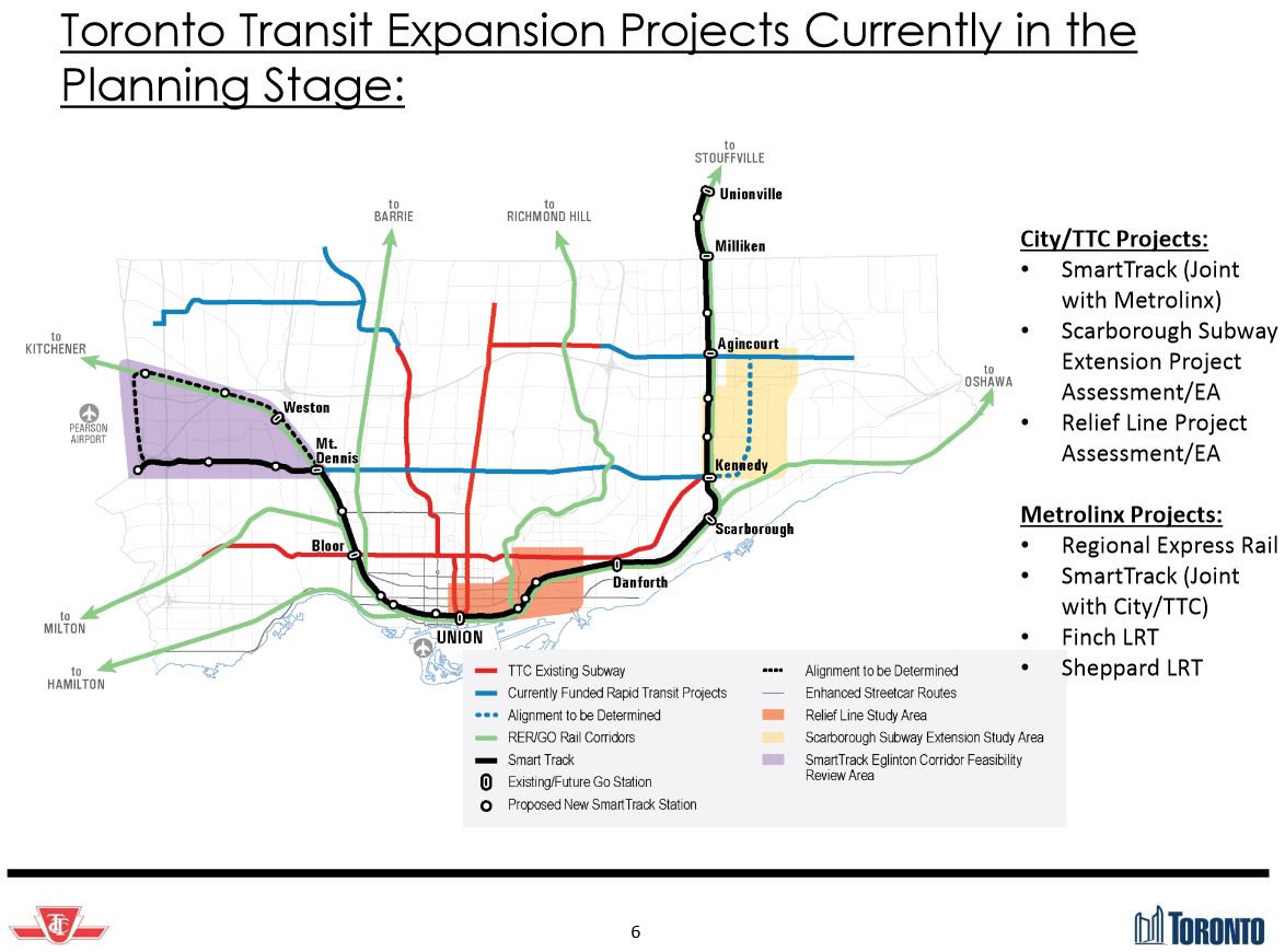
Detailed reports on four major projects will come before the TTC and Council over coming months, and these will inundate members with not only a great deal of information but force some hard decisions about just which projects, and at what scale, the City should pursue. These are:
- The Relief Line
- The Scarborough Subway Extension
- Waterfront transit
- GO/RER, SmartTrack and TTC service integration
The situation is complicated by parallel work at Metrolinx, an agency with very different goals from the TTC and the City, and by the inevitable political wrangling over the relative importance of projects. Whether any reports coming forward from staff will be trusted, especially in an environment where Councillors and the Mayor routinely dismiss “expert” advice that does not suit their biases, remains to be seen. Equally difficult will be the question of whether the reports are spun, in advance, to suit specific outcomes rather than presenting “just the facts”.
One difficulty already lurking in the wings is the question of demand modelling. The University of Toronto together with City Planning is developing a new model for GTHA travel. This is much more ambitious than current models in that it covers the entire region and models travel over the entire day, rather than focussing on AM peak flows. The model also allows for route and mode choice by incorporating considerations of fares and line capacity (crowding). At this point, the model is still being calibrated and validated, a process that uses known historical data (from the 2011 Transportation Tomorrow Survey) to confirm whether the model generates flows that accurately mimic what actually happened. (The TTS is conducted every five years by UofT on behalf of municipal and provincial agencies, and the next set of data will reflect demands in 2016.)
Draft results for the new projects and network will not be available until October 2015, and a report on details will not come to Council until the first quarter of 2016. One suspicion is inevitable given this delay: is the “calibration” intended to produce a desired outcome? That’s a tricky question both because it speaks to the independence of the process and also to the way in which the model is used. For example, a model may well reproduce past behaviour perfectly, but that’s a known target and the context for it (then-existing transit, road and land use configurations) are a matter of record.
Future modelling depends not only on the nuts and bolts of the model itself, but of the assumptions put into its configuration. A well-known example of flawed modelling was for the Sheppard Subway in which unduly rosy assumptions about job numbers and locations gave the subway a projected demand well above what it actually achieved. The further one goes into the future, the cloudier the view becomes, and the presumed distribution of population and employment can involve political as well as basic economic dimensions. If, for example, the concentration of jobs in the core area and the polarization of high and low income housing concentrations continues, this has profound effects on future demand. Moreover, such concentration may not suit politicians who view their own turf as the rightful place for future growth.
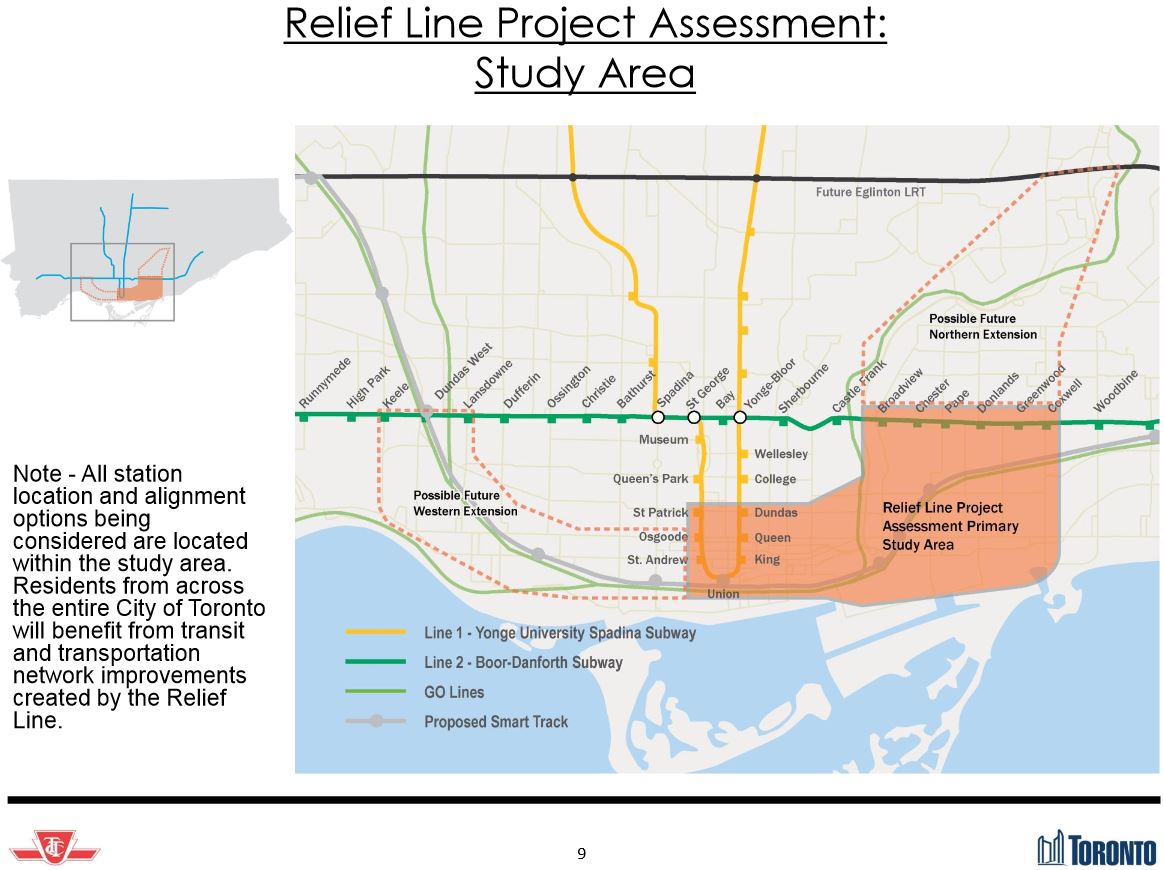
Relief Line
The City’s Relief Line study has not been marked by its blinding speed for a combination of political and organizational reasons.
For many years, the TTC simply had no interest in a “Downtown Relief Line” claiming that all future demand could be handled on the existing subway network running far greater capacity thanks to the wonders of automation. This position came unglued through a combination of factors including a recognition that even automatic control had its limitations, that the Richmond Hill subway extension was held hostage to the downtown capacity problems, and that heroic attempts to expand existing subway capacity would be very expensive and might not achieve long-term goals. The TTC now accepts that even with improvements in the pipeline, they will run out of capacity on the Yonge line in the early 2030s.
At Council, and especially in Mayor Ford’s office, the idea of building any new capacity into downtown was simply not an item for discussion even though the primary beneficiaries would be travellers from the suburbs who would gain capacity to access the growing downtown job market. The 2014 municipal election put everything on hold until staff had a sense of the climate in which any Relief Line study would be conducted.
A great deal of effort went into simply explaining that the RL was, in fact, necessary after years of pushing this scheme off of the table. The City’s study looks at three segments of the line: the primary link from the Danforth Subway to the core, an extension northeast to Don Mills, and an extension northwest linking the core to the Bloor Subway near Dundas West Station. Public consultation ran through a long list of options for station locations, and a short list winnowed this down to four permutations of alignments at the downtown and Danforth ends for the first segment. There is not yet a publicly recommended option, but this should appear imminently. It will be no surprise if the proposed line runs from Pape Station in the east to downtown via Wellington Street in the west. However, the challenges lie in how to get from “A” to “B” at least in part because no provision has been made as the city developed along the route of what had been regarded as an unneeded project.
Today the focus is on the first segment, although Metrolinx recently published projections showing that a Relief Line north to Don Mills and Sheppard would provide substantial relief to the existing subway system. It is unclear which model the pending report to Council will use in discussion of the route. If the line is pitched simply as a short connector from Danforth to the core, it will not have the same appeal (or long-term effect) as one going much further north. A related question will be whether the new UofT demand model produces similar demand projections for this route as those of the model used by Metrolinx.
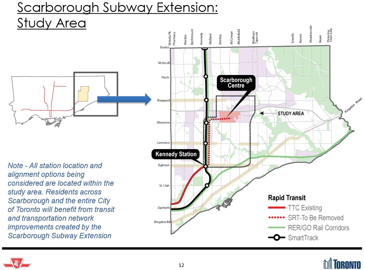
Scarborough Subway Extension
The Scarborough Subway Extension study to date has concentrated on the question of alignment with three possible routes surviving from a much longer original list. This exercise was triggered by concern that the nearby proposed SmartTrack service would cannibalize the SSE’s potential demand and that shifting the route to another alignment could improve its fortunes. Demand modelling played a big role in getting the SSE approved over the LRT network alternative, but Chief Planner Keesmaat has publicly suggested that the numbers used for that decision might not have been reliable, and they are no longer part of the City’s work. The obvious question now is whether there ever was sufficient demand to justify a subway option, and what the outcome of current modelling will be.
This is not just a question of SSE numbers, but of future projections for other lines broadly linking eastern York Region to the core area. How will the demand distribute itself depending on which lines (and service levels) are in the model networks? What will be the effect of a TTC fare frequent service on SmartTrack as compared to a GO service of, say, 15 minute headways?
The debate will come in 2016, but the moment there are “draft” numbers available, it would be surprising for them to be kept secret given the strong political opinions on both sides of this argument.
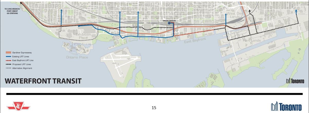
Waterfront Transit
With planning now well underway for the eastern waterfront including the Port Lands and the scheme to reconfigure the mouth of the Don River, not to mention development of the Great Gulf (Unilever) site east of the river, the question of access to what was supposed to be a “transit first” neighbourhood is back on the table. At the same time, there is some interest in transit to the western waterfront, a project that last saw any real action when David Miller was Mayor. To the east, the work is driven by new development; to the west, by a desire by residents along the waterfront, for a faster way to get downtown.
A major problem with the waterfront is that it had few real political champions except when threatened by schemes for amusement park developments, and it shares with the core the problem that the waterfront is “downtown”, terra utterly incognita to more than a handful of Council members. Waterfront Toronto tried mightily, but its focus has been drawn to other major works (Queens Quay West and the Pan Am Village) while funding limited the scope of its work on Queens Quay East to basic infrastructure upgrades (water and sewers). The TTC has never been much enamoured of the eastern waterfront line in part because of concerns about concessions that would be made to competing users of the roadway.
The Waterfront West LRT scheme goes back a quarter-century to the “subway in every borough” transit announcement by David Peterson in his failed bid to stay in office. It was always the poor cousin (a streetcar line, after all, does not have the political sexiness of a subway), and plans for this bumbled along pushed and pulled by many interests. The TTC built the Harbourfront connection from Spadina to Bathurst and rebuilt Fleet Street as a transit corridor as a first step, only to decide that this alignment didn’t really work for their plans which have shifted north to a Bremner Boulevard scheme of dubious value.
Further west there are various alignments depending on which plan you read. The original scheme at the Exhibition Place was to swing south and serve Ontario Place, but that came to naught because Ontario Place preferred to keep its parking lot rather than gain a new transit terminal. Another scheme took the route north under the Gardiner Expressway, and the existing loop beside the GO station is a legacy of that alignment. (The original loop was further south where the “Enercare Centre” as it is now called is located. A planned underground transit terminal here fell through because nobody would pay for it.) From Exhibition Place westward, there are proposed alignments parallel to the rail corridor connecting to the existing network either via Dufferin Street to King, via a new ramp connecting to the Queen/Roncesvalles/King intersection, or further west via Colborne Lodge Road to The Queensway.
The first goal any Waterfront West study needs to address is the question of just what demand it is supposed to serve beyond the level of a politician’s line on a map, and how it would relate to improved GO, SmartTrack or even a Western Relief subway line.
To the east, a planned route would run from the Bay Street tunnel surfacing east of Yonge and terminating, initially, at Parliament. Eventually this would link up with a realigned Cherry Street and service in the Port Lands including a link to a proposed Broadview Avenue extension. Much of this is years in the future, but the key part, expansion of the station at Union and construction of the link east from Bay, has been a major stumbling block because of its cost. Work that might have been done while the station was closed for construction of the new subway platform went unfunded, and further upheavals await riders whenever expansion of streetcar facilities at Union gets underway.
The estimated cost for the line to Parliament Street is $520m (2016$) of which $270m would be for the station upgrades and the new Queens Quay east tunnel, $100m for surface infrastructure and vehicles, and $150m for the reconstruction of Queens Quay East to the same general configuration as that we now see on the western side.
SmartTrack and GO/Regional Express Rail (RER)
Overall, this is probably the most important and most frustrating part of the presentation because so much detail is missing. What we do know is:
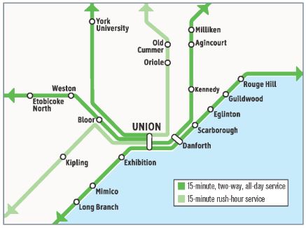
- Metrolinx wants to run many more trains on most of its corridors under the brand name of “Regional Express Rail” or “RER” with service as often as every 15 minutes, although this is a step back for levels of 5-6 minutes originally talked of in their plan “The Big Move”.
- Mayor Tory’s “SmartTrack” scheme arose during the election campaign as a modified version of a “Big U” scheme to link Milton with Markham via Union Station. The Tory version would run to the Airport Corporate Centre in Mississauga via Eglinton to the Weston rail corridor, and then follow existing GO trackage south through Union and then northeast on the Stouffville corridor.
- Metrolinx demand projections for the Relief Line study show little effect on the subway network from SmartTrack because it is too far away to do much good. Behind the scenes it is no secret that this conclusion did not sit well with the Mayor’s Office.
- Metrolinx has been and remains evasive on the question of SmartTrack service levels that would be constained by (a) the capabilities of their own rail corridors and (b) by the need to fit RER and other services into shared territory.
RER is a major infrastructure plan for Ontario and its agency Metrolinx, and when completed, it will make a huge difference in travel around the GTHA. Whether and how SmartTrack actually fits into this is quite another matter. Metrolinx openly speaks of SmartTrack as if it is simply a supplementary GO service stopping at more stations, while the TTC talks of SmartTrack as its own operation with widespread integration of TTC services and SmartTrack stations.
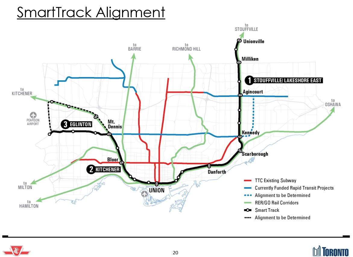
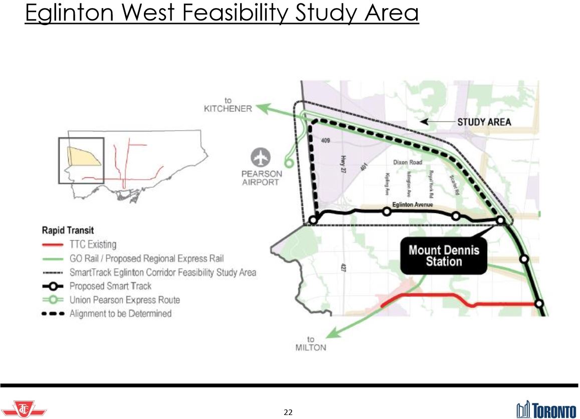
SmartTrack faces major technical hurdles beyond simply the question of service level notably the viability of the route from Mount Dennis to the airport via Eglinton West. The city is also studying alignments that would stay on the rail corridor to the point where the UPX spur branches off and then running south to reach the Corporate Centre lands.
Financially, the SmartTrack proposal is little more than notes on the back of a rather worn envelope. Basically, Tory’s campaign said there will be “x” kilometres of line, and we will multiply by an average value for “overground” construction from London and Berlin (think of “overground” as an electrified GO line), and – voila! – we have a cost of about $8.3-billion. This did not include provision for the complex link at Mount Dennis, and it was unclear for some time whether the estimate included any tunnels at all. All of this would be paid for through the magic of tax increment financing (about which I will not burden you, gentle reader, beyond saying that snake oil has a better reputation for this project).
At this point, we don’t know how where SmartTrack would go, how often it can feasibly provide service, what the fare will be, who will ride it, or how much it will cost to build or operate. Ridership numbers may come back looking great provided that trains run often and fares are at TTC, not GO, levels, but this could also have a high subsidy cost and may challenge the capacity of the GO corridors. Conversely, a less frequent service may “fit” within GO’s operations, but be less attractive to transferring riders who might face longer waits for a SmartTrack train than the benefit of a faster trip to downtown might provide, especially if this is at a premium fare.
The Deputy City Manager neatly avoided these questions because all of the studies, including engineering analyses of various routes, are not yet complete. At some point, however, the pleasant fantasies will have to end and everyone – Mayor Tory, Metrolinx, Council and the TTC – will have to discuss how all of this fits together based on real plans and engineering, not campaign promises.
Service integration between TTC and SmartTrack is possible at a wide variety of locations although this begs several questions:
- To what degree should the feeder network be gerrymandered to serve SmartTrack? (Think of how Scarborough Town Centre and Kennedy stations distort the routes around them.)
- Are all of the SmartTrack stations actually going to be built?
- What will be the service frequency?
- Will SmartTrack actually be a TTC fare operation, or GO operation with some sort of premium fare + TTC transfer privileges?
- What alignment will SmartTrack actually take in northwestern Toronto?
[Note that the image above is clipped on the sides in the full report from which it was copied.]
What’s Next
The Executive Committee meeting on October 20, 2015, should see a revised version of this update notably including some of the engineering evaluations of various alternatives that were not discussed here, but the picture will remain incomplete until the ridership simulations are finalized for meetings in 1Q16.
Any action on the Waterfront lines is a longer-term issue because Council and the TTC must first decide what or even if they will pursue these projects before a work plan to update the Environmental Assessments and/or to proceed with more detailed design.
Public consultation will occur in November 2015 jointly by the City, TTC and Metrolinx, but as with Council, members of the public will not have the full comparative picture because the demand studies will not be out yet. This could lead to “support” that is not fully informed by the final version of various studies, although how much attention will be given to such work by the current crop of politicians is anyone’s guess.
Council and Toronto as a whole will move from debating lines drawn on a cocktail napkin to a detailed network proposal, and will have to face hard questions about the value of investing in every part of it.

The Ford years were a desert for transit expansion and maintenance because of the anti-transit decrees by Ford, which were followed by Stintz. The past year experienced a tough return, but only to where they were before Ford. The next years will hopefully see transit expansion, because of possible new funding sources from the federal government (no matter whoever wins).
LikeLiked by 3 people
The bullet in the presentation that the use of transit is sensitive to transit crowding is interesting. I take it that the previous version didn’t do that.
On the surface this sounds minor, but if calibrated correctly, and if latent demand is as big as some have theorized – this could get quite interesting. I wouldn’t be surprised if the current Yonge subway and some of the streetcar lines, are already severely limited by crowding. If that’s true, then simply (hypothetically) eliminating the current crowding in a model run could have quite a big shift in the simulated current ridership. This would mean that simulations for future conditions that relieve that crowding could find higher demands on various routes than otherwise predicted – perhaps even resulting in some modal shifts, and higher demands than previously expected on constrained segments.
Any indication what they are using for the validation dataset as opposed to the calibration dataset? Typically one calibrates to one dataset, and then validates to a different dataset with a significantly changed conditions (though hard to achieve the data set in real world … but one could for example calibrate to 2011 conditions, then modify to the current network and societal parameters and see if the changes match the changes seen in the last 4 years … though in reality it is unlikely this would stress the model enough to provide significant validation.
Steve: The previous version most definitely was not capacity constrained with the result that it could model a demand that would not fit on a route, or would produce extremely unpleasant conditions during super-peaks. There is a big problem with saying a line can carry “X” passengers if this not leave some leeway for uneven headways and surges in demand (simple things like mismatched headways at major transfer points). There is no mention of station modelling to verify that the ins and outs from busy platforms can actually be handled.
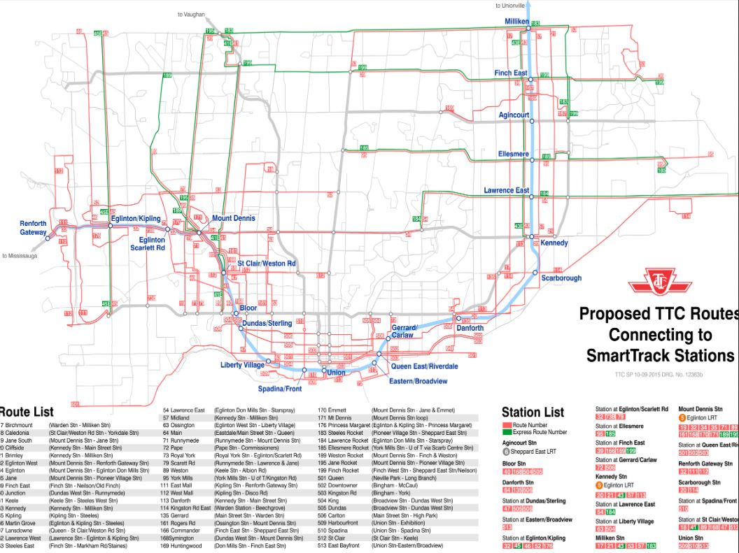
The figure of proposed TTC routes is interesting, and gives an indication of current TTC thinking on route changes with the various new lines opening in the next decade. Such as a 34 Eglinton running only from Mount Dennis station to Eglinton-Don Mills station. Or the current Jane bus being split into a 19 Jane South and 35 Jane at Mount Dennis station. Looks like that report Councillor MiHevc was asking for is already written!
Steve: A lot of the route structure for the Crosstown stations already appears in some of the design documentation where the number of platforms in bus terminals is keyed to the proposed routes. 34 Eglinton has been a matter of some debate because for quite some time the TTC was quite coy about provision of a parallel surface route to the tunnelled portion of the line.
LikeLike
I don’t understand why the Eglinton route for the “SmartTrack” proposal is being taken seriously. The alternative route which shows up in some of the studies and which makes far more sense goes to Pearson Airport and then south to Airport Corporate Centre. Metrolinx probably doesn’t want to admit that the UP Express is a failure, but it clearly is given that it has ridership lower than most TTC bus routes. This allows for both Eglinton LRT and SmartTrack (and possibly Finch LRT) to serve the airport area. In any case, Regional Express Rail and Metrolinx’s study of adding more stations throughout the GO system cover the vast majority of the SmartTrack route already.
Steve: The Eglinton route is taken seriously because John Tory ran on that proposal and now he is Mayor. Otherwise it would have been laughed out of the room months ago (probably along with the rest of SmartTrack). This is a face saving exercise.
LikeLiked by 2 people
Something that I may have missed in all the comments on Smartrack and GO electrification is an assessment of the per mile cost of electrification. I suspect that it is much higher than anyone thinks. Do you have any comments on this subject?
Steve: Metrolinx has yet to publish specific costs for its electrification projects.
LikeLike
That is very problematic, in terms of system design. This would be especially true if the same were true for the feeder routes. Should really be limiting it to say 90% of the “service design load” in the model, and see with any proposed network which lines/segments the model, shows achieving this level of saturation.
The other thing however, in all this, is that there needs to be a much larger focus on city planning & coordinated regional planning. The one issue (oddly pro and con) I have for instance with Don Mills and Sheppard being a terminus for a new subway – is the proximity of the 404/401 corridors. This means both an opportunity for a transfer point and that redevelopment in the area can also be easily auto oriented – despite our best intentions. If we are really going to make this work, we need to change planning aspects along with transit.
To encourage best use – I would hope that we would make areas with really dense transit service also areas where the zoning requirements for parking space were hugely reduced. If we run an LRT on Don Mills North of Sheppard, and on Sheppard east of Don Mills then the parking requirements in these corridors for redevelopment should be reduced to 1.25 vehicles per residence, and allow additional parking above that be market driven – commercial use being perhaps as low as .5 spots per use.
That way at least developers would have the option of building to attract people who are primarily transit users, and having less rent/real estate value tied up in providing required parking.
PS. The province should be insisting on such corridors, in more of the rest of the region as well. People would be less car dependent if they did not a) have room for a second car and b) did not have to walk across a as large a sea of parking to get to their destination.
Steve: This is all very well, but past decades have shown that we talk a good line about providing transit, but when push comes to shove, there is always something else more important. Meanwhile, development continues. Also, you are mixing an argument about home-based parking with one about the design of destinations. Those destinations are spread all over the GTHA and their form will not change overnight. It will likely be economic forces (the value of land) that dictate a move away from buildings surrounded by acres of parking, not any planning dictum.
LikeLike
What might make an interesting validation test for the revised model is if they can try and simulate the 2005 and 2014 conditions, and get anything close to the observed 17% increase in bus ridership, 26% increase in subway ridership, but the almost inexplicable 53% increase in streetcar ridership that TTC has reported.
Steve: I don’t believe the streetcar number, and it does not fit with published counts. What is your source for the three numbers cited here?
LikeLike
I am mixing the 2, for the corridors where we provide high levels of transit – after we do so. Also I fully agree that it is the market that will change this, providing there is not a zoning requirement. Right now we do not give (re)developers a choice, nor does it appear we are about to even in areas we are proposing new transit. It would take decades to matter, but zoning will not even allow the market to act.
PS – I am actually making an argument that requirements for home and commercial parking be reduced.
PPS – Also when I say home, I mean all residential – including condos and apartment buildings. Clearly this will not have an substantive effect i the near term, and can only be done in areas very well served by transit.
LikeLike
We’re lucky that Steve has gotten all this context, opinionates and shares it and then has a set of thoughtful inputs – it’s a very important set of decisions for the area, transit and the climate, where we’ve been redlining badly. So thanks very much Steve, and can we take a cue from the poverty reduction strategy, and send this all around a batch ahead of decisions?
We really need to take our time to try to get it somewhat correct, though the climate change imperative is dire. Some further data needs exist though, one major one being numbers on how most major transit expansions/projects have actually done with ridership/subsidy. It’d start with the first Spadina extension, include the Sheppard stubway, and should include the UPX waste of a corridor, and the losers will also likely include the other Spadina subway extension. My sense is that these heavy projects have benefitted construction and land interests far far more than the travelling public, and there are, or will be, ongoing operating losses/subsidies which will be buried, and not readily extracted for one reason or another. It’s not that I don’t want subsidies and projects to occur – and we give far more to cars etc. which are buried in a multitude of budgets (see vtpi.org) – but we need to ensure viability, for the system’s sake, and I doubt that most of the carservative politicians will try to be rigourous with the large gifts to the motorists ie. Gardiner Excessway, or asphalt draining subsidies and surge flows (70% of Don River surge is apparently from asphalt p. 193 Reclaiming the Don).
Steve: There are projected additional costs for opening the Spadina extension in the TTC budget papers. For 2017 there will be $11m in added cost, and for 2018 $20m. We won’t know how much new revenue the line will bring until we know what is to happen with regional fare integration, and the degree to which 905 riders will get a transfer free trip on the TTC.
The next set of data should be robust origin-destination data – and maybe they lurk some place, but with the billions in play, we need to be more logical about it than simply seeing a lot of crowding, and then throwing billions. My sense is that we don’t necessarily have such a strong demand from upper Scarborough to the core, certainly not enough to justify the SSE, and that we may well have some other options that aren’t included through bias and at times oversight. The bias being Caronto’s inability to squeeze cars – so that bus lanes on the Don Valley Parkway may be an effective buy-a-decade option.
Steve: The Transportation Tomorrow Survey is done every 5 years by UofT for all of the regional planning agencies, and the most recent data are from 2011. There will be new 2016 data, but not likely available until 2017. This is the detailed source of O-D information for GTHA travel patterns.
I’ve been especially smitten with using the Gatineau Hydro corridor for a busway within all of Scarborough as a starting point, as I think we need to begin other corridors as part of a true relief strategy. This very very wide corridor could have a small slice out of it for buses-only, and by advantaging off-road buses on the diagonal, we could have a faster 13km-ish route that would complement existing Scarborough services without taking space away from the cars, and that is a sticking point.
To complement that effort, we should dust off the old plans of linking Main and Danforth and do it; it’s not that far out and whatever emerges from RER/Smart Track, it is the logical link in the east side of Caronto to the core. As soo much of our transit push comes from the work for men and machines and resource usage, this is justifiable as a priority given earlier plans.
With RER and the Smart Track overlay, maybe the provincial Liberals were sooo keen on not having Mr. Ford around to Ford things up, Mr. Tory was able to re-brand the RER as Smart Track, perhaps with full foreknowledge/connivance, but at least with discipline to not squawk about the borrowing. The momentum behind RER meant that it didn’t matter if the financing behind Smart Track was more mathemagics given the provincial interest; and there would be a set of changes, coming soon, regardless. So at times I call it “Smart Trick” – and at least it worked, and at least there’s been some planning in previous decades for using these lines on the faster diagonal, so it’s an order of magnitude or two beyond the SSE.
I’ve also been thinking of linking the two St. Clair Ave. Easts together, but that is maybe too much of a bridge to cross over the Don Valley, and thus I’ve adjusted thinking to dream of the Gatineau busway relieving the Thorncliffe area, (yes, via a DV bridge/construct), and there are also ways to bring this service through to the Don Valley Parkway area I’m sure, if not some other options. While many may not approve of busways, in Curitiba, when political will was also shown, they were very effective mass transit, and have been used in Ottawa too.
With waterfront transit, it’s another sad set of tales about missed opportunities and built-over chances, and ever-increasing costs. The City, including progressives, just don’t want to deal with improving the east-west flows from Etobicoke/Parkdale it seems, going back decades, but one opportunity was with converting a Front St. Extension to a transitway project. A further option was to think of a busway on the Gardiner, and this might have been smart with all the repair work, but we like ignoring transit as a congestion-buster, along with the Places to Grow Act 3.2.2 and 3.2.3. A further option is almost built upon now – availing ourselves of land to the north of the Weston rail corridor between Queen and Dufferin and Front and Bathurst. It makes some sense to use Front St for better transit, still maybe possible, and I found it given support c. 2006 in the 1993 WWLRT EA where they also noted that there are two different types of demand in the west waterfront, somewhat local, and sub-regional, and Front St. transit was modelled from Etobicoke, and it was waay faster than the milk run.
Again, let’s hope everyone takes, and makes, the time for actually delving into details and we don’t rush in to another foolish to unwise project or three.
LikeLike
As far as electrification goes, it depends on how you do your cost accounting. There are extensive “enabling works” that need to be done, such as grade separations, utility grounding and bonding, track expansions, and even some clearance adjustments of existing grade separations. The last round of cost estimates had Lakeshore (East/West), Kitchener, the USRC, Willowbrook MF, and Whitby ERMF electrified for $2.14B (plus $3.4M for the airport spur at an allowance cost of $1.2M/km), excluding taxes.
Breaking this number down:
As you can see from this, it’s more complicated than straight cost per km, but includes the number of interlockings, stations, and conflicting structures.
Steve: Thanks for these details. What is the source document?
LikeLike
I think that (In my opinion) they (T.O City Council) should reconsider the route of Smartrack so that it roughly follows the Sheppard Loop Line ( If you have seen Paul Grant’s map) If they did that they would save billions of dollars not having to build a RL. It would be less expensive and it would be quicker to build.
LikeLike
Does this preclude extension of the Eglinton line to Renforth? I’d argue that would be more useful than ST going out that way. The connections with Mississauga transit are likely going to be made by riders from Etobicoke, or North York not “downtown”. At least most of the people I see transferring with me when I go out that way got on after the subway. It’s high time we look beyond Islington as the sole high capacity connection into Mississauga. And GO doesn’t cut it. There hasn’t been reverse service on the line since go dropped it shortly after inauguration, and the GO bus doesn’t stop at Kipling so it’s useless for the west.
Steve: It certainly does not preclude the western extension of the Crosstown LRT line, but Tory is showing no signs of giving up on the centrepiece of his campaign.
LikeLike
Metrolinx Electrification Project (RQQ-2011-PP-032) Conceptual Design Report, Capital Cost Estimate, Version 03 (April 29, 2015). I can reasonably say I’m the most knowledgeable person regarding the details of Electrification. The capital estimate breakdowns aren’t typically released to get more competitive construction bidding, but I can dig down into any of those numbers if need be.
Steve: This report is not posted on the project’s web page. I presume you have an alternative access to this material.
LikeLike
What are the additional costs of conversion for the purchase of the EMUs that we would ideally be using? Is the plan to jump directly to EMUs or would they start with a partial conversion, using electric locomotives? It strikes me that Lakeshore really needs electrification and resignalling / conversion in the very near term.
LikeLike
Steve: I don’t believe the streetcar number, and it does not fit with published counts. What is your source for the three numbers cited here?
The source is the January 29, 2015 TTC Ridership Analysis in the City’s open data.
If you look in the spreadsheet the streetcar ridership was listed as 42,843,000 for 2005, but had increased to 65,420,000 in 2014.
That’s a 52.7% increase for streetcar ridership.
Given that the 2006 decision to buy 204 30-metre streetcars only increased the capacity of the fleet by 48% (assuming that capacity is a function of length) would have been based on 2005 ridership data, it’s no wonder that 204 streetcars is not enough.
Assuming the data is correct. Though 2005 is consistent with 2004. And 2014 is consistent with 2013.
I’m pretty sure you’ve commented on this data before – at least in terms of the pass versus token data. Is there a difference between the current data set and earlier ones?
Steve: There is a real problem here because the daily numbers have not gone up by anywhere near that proportion. The most recent route-by-route stats published by TTC are from 2012. I have received more recent 2014 counts from TTC as background for a coming article I have in the fall issue of Spacing Magazine.
                                        2005       2012       2014
501 Queen                              41,200     43,500     52,200 (Note 1)
502/503 Downtowner/Kingston Road        6,100      6,000      6,700 (Note 2)
504/508 King/Lake Shore                47,900     57,300     66,700
505 Dundas                             35,200     31,900     32,400
506 Carlton                            41,200     39,600     39,600 (Note 3)
509/510 Harbourfront/Spadina           43,400     55,400     53,700 (Note 4)
511 Bathurst                           13,600     17,400     21,400
512 St. Clair                          31,000     32,400     38,100 (Note 5)

Total Weekday                         259,600    283,500    310,800
Annual                             42,843,000 58,657,000 65,420,000
Ratio Annual:Weekday                      165        207        210
Weekday Ratio to 2005                               1.09       1.20
Fares Ratio to 2005                                 1.37       1.53

Note 1: Queen ridership is factored up to 2013 based on a 2006 (!!!) count.
Note 2: 503 Kingston Road count included here is from 2011.
Note 3: 506 Carlton count is from 2012.
Note 4: 510 Spadina count included here is from 2010.
Note 5: 512 St. Clair count is from 2013.
There are two issues here. First off, the ratio of annual to weekday should be much higher, somewhere around 300, because typically weekend days count for roughly 50% of a weekday. This tells me that we are talking about two very separate ways of measuring passengers.
The table in the Open Data source counts fares, while the route-by-route ridership numbers count boardings. To call the Open Data table an analysis of Ridership is misleading. It is a review of where fares are paid. Note that the 2014 total of 534.8m is the total ridership measured in fares (or equivalent), not in unlinked trips or boardings. I cannot explain why the streetcar counts have gone up so much on the basis of fares collected relative to the increase in route ridership, and this is something I will pursue with the TTC. I do know that some of their reported riding counts are out of date (see notes above), but they would have to be very, very seriously out of date to make this much difference.
The TTC doesn’t do counts on its streetcar routes very often as you can see from some of the dates, and yet these numbers show up in the annual tables showing route ridership and costs throwing the ratios badly off when the counts are out of date.
All that said, I still find a 53% increase in fares attributed to the streetcar system from 2005 to 2014 to be hard to believe. Of particular note is the relatively low ratio of fares:boardings in 2005 suggesting that the 2005 numbers were not collected on the same basis as later years.
LikeLike
Yes, however, even if we are to say – reduce that number quite dramatically to say a 25-30% increase – which would be closer to consistent with population increases, it would cause one to think that there is serious discouraged ridership (consistent with overcrowding reported on King) and beg the question whether something substantial will need to be done to accommodate ridership that should be there. Also there is the issue of potential for increased congestion issues, which will dilute the capacity increase from the new cars (if/when) they get here.
LikeLike
Yes, I have access to almost all the Electrification details (ongoing negotiations for corridor expansion/purchase with CP on the Milton line are a black hole).
The fleet plan changes with the seasons. The previous numbers were based on the assumption of electric locomotive hauled consists. Frankly, EMUs beyond the UPX are probably not going to happen until after 2030 (Phase I – core network completed) at the earliest. There is a new round of planning happening now with EAs for part of Lakeshore West and UPX starting next year and construction in 2018 (shovels in the ground before the next Ontario election on a very aggressive timetable). This round wants to consider EMU operations, but the rail signals/interlockings and platform configurations aren’t designed for frequent small consists. When the Powers That Be see the difference in the price tag estimates, I think this can will be kicked farther down the road.
Service would be mixed with “frequent” “core” service being electrified and “supplementary” “fringe” service remaining diesel.
Steve: All readers talking about very frequent service on the RER corridors should take note of your comments about what the signal system will actually handle.
LikeLike
That is kind of what I was thinking/afraid of. I am under the impression that 10 trains per hour peak on Lakeshore, is getting close to point where it is required, and correct me if I have an incorrect impression – but also very close to what will be possible even with the electrification,and initial signal changes. That is – we would still be barely ahead of a massive capacity issue on Lakeshore – and between the ladders, platforms and space in the USRC real capacity for GO as a whole without radical expansion.
LikeLike
Interesting. I hadn’t realized there was such a disconnect between the daily ridership and the annual numbers from fare information.
I suppose one potential partial explanation is the weekend ridership, which certainly seems to have increased based on ancedotal observations and weekend service levels. But that wouldn’t give you over 50%.
Another explanation is just how out-of-date some of the ridership is on some routes. Is your new data different than that on the city open data website (which is more recent than that on the TTC website). The sudden increase in King ridership has been interesting.
Oh well, perhaps the data will get better when we all have to tap in and out of streetcars. (joke)
Steve: You have missed an important point here: the data on the city’s site is fares collected (linked trips, attributed to the first vehicle in a journey), while that on the TTC’s site is boardings (unlinked trips) which include transferring passengers as well as those who pay a fare. These numbers will never be the same, and the ratio will vary from route to route depending on local conditions. However, we can reasonably expect the ratio to stay roughly the same over time unless there is a massive change in riding patterns.
LikeLike
I don’t want to get too “lines-on-the-map”y, but with specific regard to the Waterfront West it seems that there are at least four distinct goals, and that until it’s decided what the purpose is, even starting to discuss plans is a waste of time.
If the goal is a rapid-transit link from south-west Toronto and south Etobicoke (with particular concern to all the new development in the Park Lawn/Lakeshore-Humber Bay area) to the core, with the goal of helping relieve the Gardiner, then any routing that has to go through the intersection at Roncesvalles is useless, as is any routing that goes along King or Queen. Also worth noting that SmartTrack/RER could eat away at this demand.
If the goal is to serve new loads originating in the Liberty Village area, you have to look at whether a line that far south actually serves the purpose, especially if there’s no feeder service.
If the goal is to improve service through the Parkdale area, then you have to address the question of how much of that is local and how much of that is core-bound, and if you are better off improving transit circulation (priority lights/lanes, etc) along King or Queen, or if you are better off shunting some riders to a new Waterfront Line at some point. (ie. at Dufferin or Jameson/Dowling).
Finally, you have to consider how any of this ties into the Bremner streetcar. If you’re proposing traditional on-street service through that area, it would very easily eat away at the “rapidness” of any “rapid transit” coming from further west and then through that alignment.
LikeLike
I’m aware of that. I just assumed they would rise in step, or very closely.
If anything with Nextbus, I make more streetcar to streetcar transfers than I used to, simply because I know I’ll only have a 2-minute wait, rather than staying safely on the one I’m on, and having to walk further at my destination. So paid streetcar fares rising faster than boardings doesn’t seem right. And does suggest that there’s a significant issue with one, or more, of the datasets.
LikeLike
Since the hourly base service to Mount Pleasant on the Georgetown line started I have used it a few times and have never got a clear run into or out of Union Station. We have always had to hold in the throat of the yard for up to 2 minutes “for a green signal” and once we were also held for 3 minutes near Liberty Village then 2 minutes in the throat. This was not in rush hour. The out bound trips were also delayed in the throat for a couple of minutes waiting for “clearance.” If Metrolinx cannot get an hourly service into and out of Union in the off peak without delays of 2 – 4 minutes how are they going to run RER on all of their lines every 15 minutes?
The recently rebuilt double ladders with all their double slip switches may be engineering marvels but they are an operational nightmare. They can theoretically tie up every track on one side of Union if a train has to go from south to north or north to south. The time required to set up routes and to change routes if necessary takes way too long. If a wrong route is selected it cannot be changed immediately to a correct route if it conflicts because there has to be a delay to make sure a train is not adversely affected and has time to see the signal change and react. One would think that the system should be able to detect trains and make changes more quickly than that but you never know when a 12,000 foot long freight might pass through Union so the signals must be able to handle it.
Operations need to be set up so that trains do a minimum of track changes once in the USRC or Smart Track and/or RER is dead in the water before it ever starts.
LikeLike
Back before all the Union construction, and the track shuffling, hourly Lakeshore West service used to arrive on one of the low-numbered (north) tracks, typically 4 or 5 IIRC. (The westbound service would typically depart from track 3.)
Westbound service would use the cross-over to pass the Georgetown-bound tracks, but eastbound from the Exhibition the train would come straight in south of the cross-over, and then have to use the ladder to move 4 tracks north. I never understood why, having (at that time) 2 tracks in the cross-over, why they wouldn’t use one for inbound and one for outbound Lakeshore West service, so that the ladder wasn’t necessary at all. Yes, it would have required some switching after Exhibition, but those switches are there, and outside of rush hour service there’s no conflicting express service.
LikeLike
There has been a lot of operational simulations of the USRC going on (looking at all possibly permutations of expansion), and generally speaking separate East/West service with double berthing at Union maximizes capacity. This is just another nail in the SmartTrack coffin.
LikeLike
I think this is one of the areas, that the clear issues emerging with GO, Union Station and the USRC, capacities, as well as the need for rapid, frequent transit to the west end, sort of all come together. There is a clear need for the region to finally look to solve some fundamental linkage issues, and start to a address the way forward. A single 17-23 km subway line can be used to basically create the backbone linkage required for a new transit development wave in the GTA.
I think in terms of a subway that tied an LRT on the Queensway through to a western side commuter station, and on through the core, to the Danforth subway, Crosstown LRT, and a Don Mills LRT at either Don Mills and Eglinton or Sheppard Ave. This link would allow a real rapid transit link from the Queensway west, support capacity for additional redevelopment around and north of the CNE grounds, in the area near and beyond the Don River, a real alternate path for growth on the Crosstown and especially commercial growth at Don Mills and Eglinton. A real LRT network in Scarborough and the associated growth in ridership on the BDL, as well as permitting Toronto itself to greatly intensify – as opposed to drive sprawl. The region has essentially reached that point to make a basic decision, like in the 1950s. The LRTs required to really drive something like the avenues plan, need to be able to link to a core system.
Simply running more buses on painfully congested streets, to massively overloaded subways – will no longer deliver the quality (or quantity) of service required. Even if we address the ladders and platforms at Union, can we actually run more than 12 trains per hour? If that is the max, and we decided that this was the answer for area along the Lakeshore, does this really represent enough capacity to serve both the inside Toronto, and the growth in traditional commuter service – especially now that all the highways are capped out? Yet – have we actually protected a route for a line that will be needed to enable so many future transit options and requirements? The route and its protection – is as essential as the Yonge subway was. This is what should have been started instead of the Sheppard subway – or the TYSSE extension (both of which should have been LRT). This line is now required to anchor the next wave of transit growth in Toronto.
LikeLike
To me this is one reason we need to protect for a DRL- end of the Queensway through to at least Don Mills and Eglinton. This single link, would allow real rapid transit linkage for southern Etobicoke – by supporting a viable LRT, provide support for a new western GO station, support continued intensification in the western downtown – by supporting the streetcars, support further development in the area around the Don River in the east and provide support for more development around the streetcar lines in that area as well, as well as providing for additional in the Don Mills and Eglinton area. Such a subway is key to growing a real broad LRT network, and increased GO capacity for the region. It can provide the key link to make the balance of the avenues plan viable, extending the subway or LRTs in Scarborough, without overloading the subway at the centre. Bus, BRT, or LRT to a subway that can be approached, and has real capacity. Running more buses approaching on massively congested roads a subway that has no remaining capacity makes no sense.
LikeLike
PS. and if the federal government is going to promise billions for Toronto for transit plans, it should be to enable transit that can actually make a difference to the region as a whole. A 7 billion dollar commitment here, would allow the city and province to build a network on it that would work. A longer version DRL, is required to make all of the GTA work, as it provides a critical cornerstone. Massive money for the city, large for the province, a quick infrastructure program for the federal, it is time for the federal government to put some money back into the GTA, to keep the golden goose laying that massive tax egg.
LikeLike
Exactly, use the platforms that require the fewest changes inside USRC, the north side track currently for UPX would be great for all Kitchener line trains. There is still a real limit to capacity at Union, and even once there is a west station, there will be real limits simply based on the capacity of subway from there to core – {at least in foul weather} and the reality of train spacing required on tracks – which would mean what 12 trains/hour or 24K.
LikeLike
The TTC has replied with an explanation regarding the discrepancy between reported growth of riding on the streetcar system as reported via fares collected vs riding counts from 2005 forward:
LikeLike
I think these names are great as in case if some people might not know about great landmarks the subways are getting named after but after this they will know about these great landmarks. This is a great way to promote major landmarks like science center and aga khan museum .
LikeLike
Kevin’s comment:
Thereby demonstrating utter ignorance of the facts that:
1) The Yonge line has run out of capacity right now.
2) Thanks to the phenomenon of Induced Demand, any incremental increase in capacity will be immediately used up.
A good example of Induced Demand is the response to the increase in capacity due to the recent deployment of the TR trains. Did this reduce overcrowding and congestion on the train during peak hours?
No. The extra capacity was immediately used up by Induced Demand.
The pent-up demand will become even worse when the Eglinton Crosstown opens up. There will be a whole lot of people who will want to transfer from the Crosstown to the Yonge subway. But no capacity for them to do so.
Steve: Actually, this is not a situation of “induced” demand, but of latent demand that is there already, but simply cannot reach the most congested part of the network because of upstream constraints. We know that trains are very crowded already on the north end of the Yonge line at peak, and running larger/more trains simply allows this demand to reach Bloor sooner that it might have otherwise. There has been a long-standing effort by both TTC and Metrolinx to downplay the capacity problem on the existing subway and “plan” for the crunch to arrive in the early 2030s. They are not beginning to realize that a relief line is important, but political pressures (availability of financing, the perception that this is a “downtown” project, and competing “visions” such as SmartTrack) keep getting in the way.
The ongoing issue with delay of demand projections with the UofT’s new model don’t help one bit, and the premature commitment by Harper to SmartTrack, rather than to generic spending on new transit, before we know this really is “the solution” shows that the feds are simply pandering, making a supposed quick fix promise to a Mayor who is fixated on his own legacy design.
LikeLike
Amen, the money basically be to support projects that represent critical transit infrastructure – as should have the Scarborough subway support. The major requirement should be thorough study with the politicians kept at bay. Since SmartTrack cannot be implemented without undermining RER on the same route, the money should either be to generically help RER, or to provide support for a subway or transit network with the highest potential to have the largest regional benefit.
I would prefer to see a stepped promise from the fed tied to a real network, and the enabling critical structure. The situation in Toronto can be greatly improved – but fiscally the feds muscle is required. The DRL is a classic of being required but not sufficient, and a Transit City LRT & BRT needs to be overlaid on it, as well as regional lines beyond.
LikeLike
Kevin’s comment:
I don’t quite understand what you consider to be the difference between “induced” and “latent” demand. Wikipedia uses the terms as synonyms.
In my opinion, there is a fairly high level of pent-up demand for travel on the Yonge subway during peak hours.
Anyone who currently travels on it during peak hours can see the falsehood of the TTC assertion that “they will run out of capacity on the Yonge line in the early 2030s.” They are out of capacity today.
Steve: “Induced” is demand that would not be there but for added capacity. I distinguish this from demand that already exists but cannot reach the peak point because of capacity problems further out. Riders are delivered to Sheppard and Eglinton Stations by feeder services, but there is no guarantee they can get on the trains. “Induced” demand on the other hand would be people who don’t use the system now, but say “I have heard the trains are empty” and change their travel patterns and/or more choices.
It may seem like splitting hairs, but there is an important distinction between the two types of demand. Wikipedia’s definition deals more with a store than runs out of goods, than one which has the goods but cannot sell them fast enough because there are too few checkout lines.
LikeLike
Just because Wikipedia uses them as synonyms does mean that they are. According to several dictionaries induce means:
where latent means:
I tend to agree with Steve, probably because we are products of the Toronto School system in the same era which stressed the correct meaning and proper use of words. When GO built the Lakeshore line in 1967, a number of apartments were built soon after in Port Credit. This was an induced demand that did not exist before the service started. When the Yonge subway started the ridership was much higher than the lines it replaced, Bay, Yonge and Danforth tripper. This was a latent demand that existed but could not be met because the capacity was missing.
A new transit system that is properly thought out and located should result in meeting latent demand and inducing new demand. This is why there can never be an extension of the Yonge subway north of Steeles before a DRL that runs way north of Eglinton. The latent demand south of Steeles is probably greater than the extra capacity that would be created so there is no room for the residents of York region, sorry.
LikeLike
While I would agree with your sentiment, I believe that the comment about running out of capacity was aimed at the capacity that would be available after the new signals are complete and the TTC is able to run 33 or so trains per hour (as opposed to 26-27). However, I believe that there is a substantial amount of demand that is currently being frustrated by not being able to board trains – or even get to them for lack of space on buses, (shortage of buses and road congestion). There is also a large number of purely discouraged riders that know this will be the case. It would be interesting to know the numbers of people stuck on platforms, at bus stops and those choosing not to ride.
I wonder if we would use up the capacity to 36k before the word got around – if it was magically available, and we secretly started running more buses.
Steve: Don’t forget that the TTC expects to shift several thousand riders in the peak over to the Spadina leg when the Vaughan extension opens. That is in addition to the gains from resignalling and ATC. But, yes, they will eat up all of the new capacity fairly quickly.
LikeLike
I wonder however, how close we would get without even having induced demand, but merely tried to meet the latent demand – even that which is stuck in the system. Perhaps better put, simply from unclogging the pipes.
LikeLike
I am somewhat concerned with regards to extending this north of Steeles- even with a DRL to say Sheppard. The study seems to indicate a diversion of load on the order of 20k to the new line – and thus a demand on Yonge of well within capacity – however, without adding load from the north I would expect the load on Yonge to be at least 21k from within Toronto growth, just based on natural growth of 2% from existing. If you were to reset this number to something reasonably higher based on frustrated latent demand say to make current a mere 34k you end up at 25K if only 20k is diverted. This is without adding additional load from a Scarborough subway or LRT extension or removing for TYSSE diversion. I would not expect these 2 factors to offset each other, which to me means – if you add the 9K or so additional load from Richmond Hill you are again close to the limits on Yonge, very shortly after 2030.
A DRL is required for Toronto to absorb a higher share of the regional growth, and reduce sprawl and extend transit across the city, never mind Richmond Hill. Committing to an extension to Richmond Hill – without seeing the impact of TYSSE, the impact on ridership of the Sheppard East LRT, the impact of the SSE, or a real LRT network in Scarborough – is frankly foolish. Build the DRL at least as far as Eglinton, and the projects that would enable, and then see where you are – maybe link Richmond Hill with an LRT, to Steeles, but tread carefully.
If you bump the starting number on Yonge (based on the notion it is currently capacity constrained) to 34 and growth to 3% you are looking at a 52k demand in 2030 between the DRL and Yonge- without adding the additional induced load from York region. Do we want to induce growth through higher density in Toronto, or just more growth in York. Also the load will not likely be evenly split between the DRL and Yonge, so we can reasonably assume 60%+ to Yonge or 31K right out of the gate.
LikeLike
Personally I don’t see what the SSE will achieve that a bigger, badder bus terminal couldn’t at Downsview or Yorkdale. We could have seen much more local service from GO, Brampton and Vaughan transit into those terminals. Why go buses and others don’t take the busway to Downsview after letting the students off at York already is beyond me. This would draw a lot of the bus crowd from the North and West away from Finch. If we spent the money going to the subway on subsizided transfers there would be better transit for everyone in that corner of the GTA.
This could have been done by now. Yet we’re no better off on Keele than Yonge.
LikeLike
I think we can comfortably say that for a couple of election cycles a seat or two has likely been secured. However – I would dare say that is really what the extension beyond Steeles is about – as is the proposal on the Yonge side. Winning elections – not best transit practice.
LikeLike
Steve I was noting in the discussion of the LRT they were limiting that to a 2×40 metre LRT, with capacity of 450/train at 20 trains per hour – or 9k. Would this not have made more sense at 3×40?
Steve: All Toronto LRT facilities have been designed around 3x30m. I don’t know where the consultant got 2x40m.
In any event, any “LRT” proposal that involves any on-street operation isn’t going to go beyond 90m trains and platforms. There are basic constraints such as road space, not to mention pedestrian flows to/from platforms if operating at a much higher capacity. Don’t forget that the Bloor-Danforth streetcar at its height was carrying somewhere around 8k with 45 (packed) two-car PCC trains/hour.
LikeLike
In some areas – far from the core- I can imagine on street operations with larger trains; however, it would require a situation where crossing streets were limited (hundreds of metres between), and the pattern of boarding and alighting was such that the stations that saw real pedestrian flows would not require pedestrians to cross – that is special stations that were in effect grade separated. Say for instance for the Eglinton LRT – (once full length) will likely need grade separated or equivalent stations for the airport as well as the subway (Spadina, Yonge, and DRL) and Mt Dennis GO connections.
Steve: Which it will have because stations at Mount Dennis, Don Mills and the Spadina, Yonge and Danforth subways are already grade separated.
If Metrolinx were to deem that Finch should run full length, same idea, with Airport, Malton GO, Keele subway station, and possibly, Sentinel, and Humber college, requiring special treatment, and if it were to be extended – Finch subway, and Don Mills LRT. However, in principal, yes, the idea of say half a train of 500 riders getting off at a station that had no special treatment, and then trying to cross at lights/crosswalks would be a dangerous nightmare, so any location likely to be subject to very high loads could not look like the balance of an on street LRT.
Steve: The Finch/Keele interchange is also grade separated. Provision for this was included in Finch West Station.
LikeLike