
The Transit Investment Strategy Advisory Panel has ventured off its supposed path of looking at ways to fund transit growth in the GTHA to at least one proposal for a change to the Metrolinx Big Move plan. This showed up at recent open houses in a handout that is not yet available online.
[The image above was posted on Twitter by Rishi L (@CdnEnginerd). Click for full size version.]
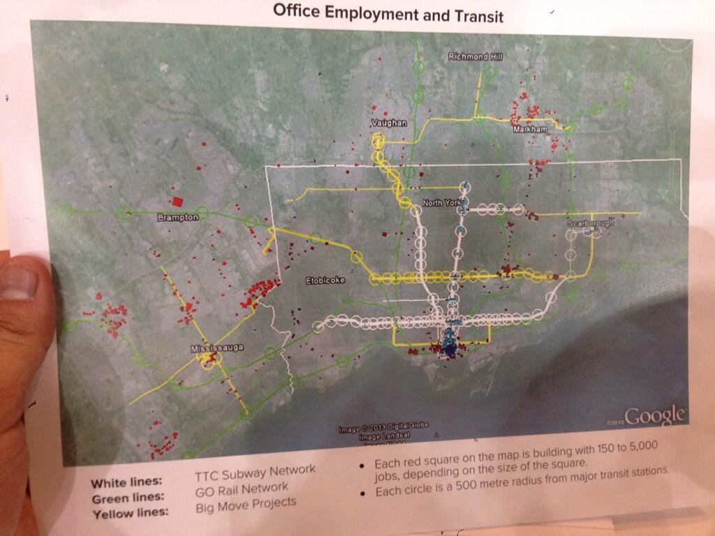
The purpose of this map is to show how office employment is not sited along existing or proposed rapid transit lines. With this as a jumping off point, the Panel suggests there is a need for a “Big U”, a much enhanced GO Transit route from Meadowvale, through Union Station and then north via the Uxbridge Subdivision (Stouffville line) to Markham.
A related factoid (one of those handy bits of information whose presence is supposed to silence critics) is that employment concentrations generate far more transit usage than residential ones. It is certainly true that it is much easier to serve a place like downtown Toronto with a transit network that acts like a big funnel, but this does not eliminate the need to serve the residential ends of those trips.
Toronto’s Bloor-Danforth subway and GO’s commuter lines, for example, spend much of their time running through comparatively low-density neighbourhoods, collecting passengers as walk-ins, park-and-rides, and transfers from the surface transit network. Every time a new transit route is proposed, we hear how it will only be viable if stations are surrounded by huge condo developments. This is utter nonsense because any transit route has a catchment area. The problem is to ensure that transit, sidewalks and bike lanes serve that area and deliver riders to a network that will take them where they want to go.
What is missing from the chart above is any indication of where the people who work in those centres actually live. Looking at the Meadowvale end of the line, how many people come from the area that would be served by the GO corridor and a feeder network to it? There is a lot of territory north, west and south of Meadowvale for which a rapid transit line to the east will do absolutely nothing. Similarly, many who work in Markham live west, north and east of the employment centres. Indeed, most of the red dots on that map are well west of the rail corridor.
Much as I sympathize with the Panel’s desire to get people talking about how parts of any network proposal might actually serve the region, I fear that we are seeing a classic example of someone who got out their crayons and drew a map. The job will quickly change from discussing the philosophy of transit planning (and, don’t forget, funding) to defending the specifics of a proposal.
That is precisely why I have been so restrained about getting out my own crayons except in special circumstances. The recent Don Mills Subway discussion needed a line on a map to illustrate how the “downtown” focus needed to change. Well over half of the debate this triggered became a matter of dueling proposals between “my” line and “your” line that added little to the real issue — the need to see what such a line could connect and serve beyond simply diverting trips away from Bloor-Yonge Station.
People would even argue that there wasn’t “enough” development in some locations to justify such a route ignoring what is there today, what is in the pipeline for tomorrow and what could occur with planning and political encouragement. Meanwhile, we build a subway to land that was recently the middle of nowhere, and propose one through miles of low density residential development as a vote-buyer claiming that only with a subway will Scarborough reap the development it “deserves”.
There is one big problem with the “Big U” — it diverts attention from the “little u” otherwise known as the “Downtown Relief Line”. It doesn’t help one bit that the version of the “little u” shown on the map is the Pape-Queen-Roncesvalles alignment, one that is guaranteed to be very expensive and fails to recognize shifting development patterns (ironically, one of the goals of the “Big U”). It ignores the southerly shift of population and jobs, avoids the available Weston rail corridor where we are spending a fortune to intensify transit infrastructure for a Toonerville Trolley to the airport, and it stops at the Bloor-Danforth subway missing the opportunity to reach further north to be more than a “downtown” line.
“Alternatives analysis” is a fine art in many projects, but the real art for many agencies is to ensure that what you always wanted to build is the “preferred” choice. This is often guaranteed by setting up straw man comparisons so that the one you want shines out as the best of breed. Such may be the situation with the DRL where, on darker days, I suspect that the whole idea is to paint as grim a picture as possible so that it will never be built. Remember that the TTC for decades claimed we didn’t need a DRL, that they could stuff everyone into an upgraded Yonge-University line. Expanding YUS capacity on a heroic scale was their “preferred alternative”.
With the Big and little U’s, we risk being trapped into specifics of route designs that looked good on a napkin in a bar, but which need much more thorough discussion as to purpose and specifics. They are good as starting points for discussion, but are most definitely not the final answer in their respective fields. Moreover, they are not alternatives to each other, a point that is often lost as the political imperative says “build in the suburbs, not downtown”.
The Big Move and the Investment Strategy that supports it have one gaping hole. Very little attention is paid to the role of or funding for the feeder network to a regional system. Moreover, the plethora of lines on the map hides the fact that many of them will not have the most frequent service on the planet. Not all “rapid transit” lines are created equal. As a recent Metrolinx report noted, the growth in “rapid transit” recently has mainly been in “BRT Light” for which the infrastructure requirements are minimal along with the service levels. Crowing about progress in bringing transit to the millions ignores the question of how attractive that transit will be and how people will connect from the trunk routes, such as they may be, to their homes, work and other destinations.
This will be an important issue for network design on both the Big and little U’s. One would serve rail corridors and be totally dependent on local service to deliver riders from homes and to employment locations. The other would serve established and growing neighbourhoods and would enjoy an existing, well-developed set of local transit services as feeders. These are not trivial differences, but they show the problems that will arise if the study does not look beyond the edges of station platforms.
This is the real debate the Transit Panel should engage — does The Big Move really serve the market it claims to address? How useful will it be in attracting trips out of cars and onto transit? Can developers and owners of residential and employment properties expect a real improvement in travel to and from their developments, or will their value be strangled by poor access? Underlying all this is the basic question of whether we are spending all of those billions in the “right” place and what benefit each component of the proposed network will achieve. That speaks directly to the concept of spending wisely, not just for the sake of generating construction jobs and photo ops for the next generation of politicians.
Returning to the “little u”, there will be a motion before Council from Councillor Josh Matlow, seconded by Cllr. John Parker (also a member of the TTC Board), to accelerate work on the EA for a “Relief Subway Line”. Moreover, it asks that Council confirm such a route as “Toronto’s next subway expansion priority”. It will be intriguing to see how this motion fares amid the current circus at City Hall, the recent battle over the Scarborough Subway and a faction claiming that downtown “has enough subways” already.
If this proceeds, it will be vital that it not be hamstrung with narrow terms of reference that filter out options before they are even discussed. A major shortcoming of the new “Transit Project Assessment” protocol is that there is no consideration of alternatives because the decision that something is a “good project” is already assumed. Debating alternatives just gums up the works in what is supposed to be an expedited process, but actually winds up as an exercise in selling an already-determined choice. This is precisely the criticism many had of Transit City that compounded the process with less than stellar detailed planning and “sales”. (Moreover, once a project is approved, it can be amended beyond all recognition, even though the original design was the one that “justified” the project in the first place.)
There is no point in doing a study if the underlying desire at the political and staff level is to sell a “Big U” as a replacement for the “Relief” line, whatever we call it. The terms of reference must ensure that all options are reviewed, including cross-jurisdictional issues such as repurposing the Weston corridor’s UPX trackage for rapid transit. We must not prejudge the outcome by requiring one continuous line to serve both legs of the U/u, especially considering that in some variants both western legs run in the same corridor.
Will Toronto Council, Metrolinx and Queen’s Park embrace the need for a full study of these routes without prejudice toward any preconceived doodlings on maps?

That picture only shows office employment, and further, only employment in buildings with 150+ people. There is lots of non-office employment in the GTHA, which generates just as commuter travel as office employment. (The area west of the airport is not houses…).
Also, it shows the Hurontario-Main LRT stopping at the border with Brampton, when it should run all the way to Brampton GO Station. (And UpEx only goes as a far south as Eglinton!) Basic errors like undermines the credibility of the arguments built on that map.
Steve: As I said, someone got out their box of crayons. I wanted to concentrate on the conflict between the two “U’s”, not get into picking apart the map beyond the obvious observation that the employment in Markham is not beside the GO corridor it is supposed to serve. It’s one of those arguments that sounds nice in theory, but when you look at the details on the map, things start to unravel. Another obvious omission is any discussion of electrification to support frequent service and the difficulties this raises on the CPR Milton line.
LikeLike
I do not want to sound prejudiced, although I most probably am – these ideas and charts are so “high-level” that they are useless to general public and therefore time-wasting. Like you, I have worked at IT and sometimes people (vendors’ representatives) had these fancy ideas about client’s needs without really fully knowing and/or explaining to the clients “market-place availibility” and/or understanding client’s current environment. The “Big Move” has reached this point.
Where would I start?
(a) Let’s forget about fancy analysis, dots, polka dots, smileys, floating swans and so on.
(b) make full inventory of closed and/or partially retained (not built-over) or even currently used (although may be of questionable quality – Uxbridge) railway ROWs.
(c) let’s make full list of safety protocols that refer to railways operation whether national or international (FRAs) whether direct or indirect.
(d) let’s make a list and compare safety protocols in Europe and in N.A.
(e) let’s make a full list (or at least a category) of all railway vehicles (or tram-trains) types that are used elsewhere, including dual voltage (Karlsruhe, Germany), mixed power supply (Kassel, Germany), mixed power delivery (pantograph vs. third rail) and such.
(f) let’s make a map of all geological fault lines (earthquake protection/mitigation).
(g) let’s make a map of all soil types (including flows of underground water).
(h) identify all or most of points of current or projected capacity saturation without providing a solution at this time (Bloor/Yonge subway cross-over, Union Stn.)
These maps and/or listings do not have to be exact nor should they provide a solution.
One main point of conflict between rail transportation and general population (beside being in danger of being killed at railway crossing) is, that people do not want to listen to honking of trains or have their houses being shaked-over by a passing train. These reasons alone most probably push developers away from railway lines, although in social/population moving terms this type of development is most probably highly desirable.
Once these inventories would be completed (within 6 months), we can engage John Torys, Ann Goldens, Metrolinxs, McCallions of this world and we can have a useful discussion – otherwise we are just treading water and going nowhere fast.
Steve: To your list, I would add an inventory of significant barriers to construction in specific places such as underground structures. It is astounding how many times people draw lines on maps right through the middle of stuff, and then get really ticked off when they are told it “won’t work”. I remember a map of proposed all night services on the TTC years ago that showed walking distances to transit from various locations, but took no account of geography including the need to swim across Grenadier Pond, among other significant landmarks. They were not planning all-night Swan Boat service.
LikeLike
So who drew up that map? Not only does it show a poor DRL fantasy alignment, but suddenly the “Big Move” Hurontario-Main LRT terminates at Highway 407 – instead of continuing north into Brampton.
A big problem about that job cluster in Meadowvale is that all those low and mid-rise office buildings is that they seem to be built with Highway 401 exposure in mind and ample and easy parking access and little else. There’s Meadowvale GO Station, but it’s a 10 minute, lonely walk from the BMO back office building, built next to the 401 and the closest new development to that GO station. The office towers to the north of Highway 401 are very far and rely on a Mississauga Transit express bus from Islington Station to feed them Toronto reverse-commuters.
Steve: A classic example of someone who looks at a map from thousands of feet up, but doesn’t understand what’s on the ground.
LikeLike
The diagram’s case for favouring the GO Stouffville line over other projects seems poor. GO Stouffville does not come near the Highway 7/Leslie office cluster.
(Incidentally, Leslie in 905 is a continuation of Don Mills in the 416, which suggests that a line up Don Mills may be much more relevant.)
Steve: Yes, it would, but the panel member who is in love with the “Big U” doesn’t want anything to do with Don Mills because he thinks that time has passed it by and it’s not worth the investment. (That is more or less what he said to me when we talked about this last week.)
LikeLike
The BIG U in terms of an enhanced GO Transit network is long overdue and should be the next priority of Metrolinx ahead of any debate on subways or LRT. In addition, let us double tracks along all single tracked routes and electrify the routes followed by moving stations to major intersections like moving the Oriole GO train station to near Leslie subway station. Subways whether in Scarborough or in Downtown cost too much money and GO Transit can provide a much better bang for much less the cost.
LikeLike
I was surprised to see how much greenfield land remains to the west and north of Meadowvale. Is this land protected by the official greenbelt? Even if it is, will a possible future provincial government repeal the legislation and open it up for development? This might make the big U line more viable if there is a lot more residential construction still to come.
Since 1980 there has been a growing reverse flow of commuters living in the 416 and working in the 905 but I expect most of them are forced into driving. This is even more likely for people who live in one 905 suburb and work in another. Does the census provide enough data to determine how much of this commuter travel demand can be served by the big U?
Though the suburban office parks in Meadowvale, Markham, and elsewhere in the 905 appear fairly concentrated on the map shown, they are actually very dispersed by city standards. Is there adequate local transit to connect the GO passengers from the train station to their workplace? Unlike the people who actually live in the area they won’t have their cars with them to drive back and forth to the GO station. Seems like an obvious little point but sometimes people overlook the obvious.
I do feel felt that Metrolinx has reduced their emphasis on GO rail expansion recently. Given the pressure that some 416 and 905 suburbs have exerted on Queen’s Park to get subways extended into their areas, perhaps the remaining 905 suburbs with no hope for a subway are now pursuing the same strategy for improved GO rail service. The Transit Investment Strategy Panel might be a precursor to a shift in policy from the province.
As always with transit, politics prevails.
LikeLike
This is why I think that a subway along Don Mills going further north than Eglinton is needed. Ideally it needs to be built up to Highway 7 in phases. This is needed because of the large concentration of office space along the DVP/404, the severe traffic congestion along that highway (the DVP is by far the worst congested major highway in the GTA, especially between Eglinton and 401), and Yonge line overcrowding. The Richmond Hill and Stouffville lines do not go anywhere near most of the existing office or residential developments in that corridor.
Similarly the Eglinton LRT needs to eventually be extended west along the route of the Mississauga BRT, and connect with Square One, Hurontario and the Milton line at Erindale. The likely high usage of that section of the line is why Eglinton really would make more sense as a grade separated line. Building a trench through the Richview Expressway corridor is not very expensive.
LikeLike
I was surprised to notice numerous errors posted in the map, so much so that I feel like there is no point in listening to the Transit Panel if they can put their names on such an inaccurate map.
That said … I’ve often thought that a Crosstown GO line running from Meadowvale to Meadowvale would be a great thing to have … if it came with frequent, 2-way all-day service and connected to a comprehensive network of feeder buses (with car/bike share available at each station).
That said, any talk about such a line is completely premature until the CPR stands up and says “yes, we agree to sell our mainline through Toronto to Metrolinx and divert our trains onto a rail line owned by our greatest corporate rival” (or alternatively “we have agreed to allow Metrolinx to pay to expand and/or tunnel under our mainline through Toronto”).
So not only has the Transit Panel gone “off track” and lost sight of their purpose (which, to be honest wasn’t entirely clear to begin with) … but they’re also losing credibility quickly with these error prone maps.
Cheers, Moaz
LikeLike
On the subject of the Downtown Relief Line being a discredited name I suggest City Core Line.
LikeLike
The diagram is very close to a presentation made to Planning and Growth in January 2012 by Iain Dobson of ReSearch Corp.
This will provide some background.
Steve: And Iain Dobson is a member of the Transit Panel. You can connect the dots. The question is whether one member’s position is skewing what we see of the panel’s work.
LikeLike
To be fair to the Panel, the discussion wasn’t supposed to be about lines or technology, it was about the funding tools used to pay for whatever will be built. It seems that people have a hard time speaking about the more abstract concepts of equity and the fairness of the tools and instead tend to focus on the concrete discussions involving ‘crayon drawing’. Lines and technology are definitely important discussions, but are beyond the scope of what the Panel was supposed to do. Just saying.
Steve: My critique is more to do with the problems that can arise if the line-drawing exercise overtakes the philosophical discussion about how to pay for a network. As we have seen here and on other sites, the moment a specific line is mentioned, the technology and alignment wars take over under the guise of “improving” the proposal.
LikeLike
I wish someone would combine this population density map from statscan with Map 1 on this Urban Toronto thread showing employment concentration. [Note: You will have to scroll down to see the map in question.]
The map [at the start of the Urban Toronto] post is similar to the statscan site and more clearly shows that where there is the highest density in Toronto is the area from Bay to Parliament, from College to Bloor … yet east of Yonge there is no major line north to the Danforth line.
It does show the concentrations in Thorncliffe and Flemingdon Park are pretty clear.
West of the core, south of Dupont from Spadina to Lansdowne is pretty intense too … and there are lots of jobs north of the CNE.
Pape/Donlands is neither an area of job concentrations or population density.
Steve: Any line leaving the core to the east must head north through some areas that don’t have as dense a residential or working population. However, what does not show up on these maps is the redevelopment in the West Don Lands now in progress, the planned commercial and residential development on the Lever site, and the potential of the Gerrard Square site. I can think of many other similar areas now traversed by busy subway lines.
LikeLike
I remember seeing this when it was first published but didn’t realize the author is a member of the Transit Panel. I can’t dispute the report and find it useful but only because it validates what I already believe about suburban office parks. They’re lousy places to work and lousy places to commute to even if you’re driving, never mind taking public transit.
LikeLike
@ Moaz Yusuf Ahmad
It would be interesting to consider this idea in conjunction with the federal government’s proposed Pickering airport plan.
Steve: And we will see whether the Feds’ love for passenger trains on the CPR through Peterborough survives the end of the Harper regime and Jim Flaherty’s attempt to revive the local railway through his town.
LikeLike
The question that must be asked is, “would the construction of the big U help to sufficiently reduce political opposition to allow for the construction of the small U.” The projects are not necessarily mutually exclusive.
LikeLike
First of all, I attended the panel, and I appreciate that you listed me as the photo reference after I posted this on Twitter, Steve, so thanks for that.
I think it should be important to note that we never actually spent any time discussing the map. It was left on the tables along with a number of items. It’s printed on heavy card stock and is not branded by any agency. There were a number of reference tools and cards on the table that no one looked at or touched, and most work was done on a note taking booklet to answer our questions and feedback (see below).
The panel did not discuss any particular route or details. It started with a high level discussion between Anne Golden & Royson James about the purpose of the panel, how we can grow and tackle this as a region, and it was correctly referenced as the key issue of our generation.
After this, we broke out into small discussion groups, as a similar rehash to the Metrolinx events back earlier this year, where we discussed the circumstances that we were willing to pay for transit and which revenue tools, and what we felt the key selling points of the plan should be and why the discussion was so hard.
The panel members were mostly there, but were quiet and positioned at each table and listened openly. In my case, I led the discussion of my particular table as the moderator.
I think I would say that throughout the many different events I’ve attended over the last year (City, Metrolinx, Transit Alliance, Code Red, Rransit Panel, Planners Roundtables etc.), I find the generation gap quite interesting to observe from a discussion standpoint and in evaluating information & considering information open-ended, and not derailing to go off on tangents. I am not intending this to stereotype one group or another, but I am throwing this out there as an anecdote that I’ve noticed to be quite interesting.
I tweeted about the map, because regardless of the line plan inaccuracies, I just found the disconnect between employment hotspots and planned lines to be striking. A point was made that how good transit is about access at your designation, because source transit stops need to have feeder routes to make sense.
The panel is only advocating smart discussion & depoliticizing the planning. I know we like to go full out pessimist on this blog right away, so I’m not sure why I feel the need to defend them, but I continue to try and see the glass half full.
Steve: I flagged that map because I know that the panel member who is pushing the “big U” plan has the ear of the Minister, and the last thing we need is more back-of-the-envelope restructuring of The Big Move by Ministerial announcement. Its presence at the meeting suggests that there was a desire to have it there, but not to actually discuss it unless someone brought it up. An internal compromise, possibly, to keep panel members happy.
The disconnect is quite striking, but it applies to many lines (including claims made for the Big U), but more is involved in figuring out a network design that just drawing one line between dots on a map that represent only one part of the travel demand. Another issue, one that was raised at a session last year at York U, if I recall, was that academic institutions generate huge amounts of travel demand, but this is neither “on the grid” in many cases, nor does it necessarily match conventional commuting times. It is a market that is usually ignored as part of large scale plans that are pre-occupied with “congestion” and getting people to downtown Toronto.
A central problem with TBM is that it has only modelled the benefits of the plan in the aggregate and we don’t know how much each component contributes to the whole. Moreover, we don’t know what demands are missed and therefore will continue to generate congestion even as we spend billions elsewhere.
As for whether that glass is half full or empty: it’s no secret that I think the DRL/Don Mills/whatever line is something I have strongly supported for a long time (notwithstanding claims to the contrary by some subway jocks). I am very concerned when I see “planning” that suggests we can somehow get by without a DRL for travel that originates inside the 416. Of course more GO service is needed to bleed off travel growth from the 905, but this does not replace the need for more “in town” capacity. Sending up a flare about a half-baked proposal, especially when it comes from an important advisory panel, is essential.
LikeLike
There is no such thing as an unbiased opinion. Everyone makes a decision based on some set of values and this is based on mine. I do not apologize for my biases.
The major problem seems to be the conflict between what is needed in the inner 416 and what is wanted, whether it is needed or not in the outer 416 and 905. These can be complementary but they cannot be substituted for each other. The original Yonge Subway was built by the original 34 square mile City of Toronto but opened under the 240 some square mile Metropolitan Toronto. The Bloor Danforth was a logical next step. University was only built because Yonge would not be able to handle all the rush hour traffic. Does anyone remember when University did not run after 9:00 p.m. or on Sundays and Holidays. It was replaced by one bus on 5 Avenue Road.
Not building the DRL in the 70s was one of the biggest mistakes Toronto has made in transit planning, and there have been many. Building the “Big U” before the DML will be another. Many people moved to the 905 because they wanted larger house and more open space. The trade off was poor, or no, transit service. They now want city type transit while keeping their other benefits which are not fiscally compatible.
The next heavy rapid line should be the DML to at least Eglinton. If Metrolinx or the province wishes to extended it fine but only 1/2 or 1/3 of the trains should run into the 905 with an extra fare or extra subsidy from York. The same should be done with the YUS into Vaughan. Yonge should be extended only to Steeles, mainly to get all the buses off Yonge north of Finch with every second train turning back at Finch so 416 customers have a fighting chance at a seat.
If these transit advisers want service to Markham then extend the useless Scarborough extension of the Bloor Danforth up McCowan to York’s BRT. Then when it is converted to a subway we can have more useful discussions about “closing the loop” and joining then together and also to the YUS in Vaughan so you can get a one seat ride from Kipling, probably Square One by then, to Finch and Yonge via the known world, just kidding Steve.
We need to realize that no one system is right for every situation. A system on the MetroLinx owned rail lines like Sydney’s “City Rail” would be more useful then more conventional GO trains or Subways to nowhere. Now if there was only someone at the TTC who was familiar with City Rail…..
LikeLike
All modes must be considered. What about a Don Mills LRT North from Eglinton? Then if it gets overloaded, a parallel Leslie LRT can be built starting at Don Mills and Eglinton, West on Eglinton, North on Leslie to Steeles. The Don Mills LRT can continue/connect into York Region on Leslie St. in York Region. Needless to say, this combination of two lines would provide service over a much broader area than one subway line, and would be more resilient in case of emergency.
The cost of these two LRT lines would probably be much less than running the Don Mills subway to Steeles. I don’t, however, know enough about the demand closer to Leslie St. to know if it would actually pick up much traffic.
Oh, and before anybody says anything, single seat ride shmingle seat ride. I mean, sure, let’s not put in pointless transfers for no reason, but also let’s not spend tens of billions of dollars extra just to eliminate a few transfers, when we could be using the money to put LRT on many more streets all over the City. The Don Mills/Eglinton station could and should easily be designed to make all transfers extremely convenient.
LikeLike
Remember that the DVP is much busier and more congested north of Eglinton than south of Eglinton. Why does it make sense to use a low capacity mode north of Eglinton and force everyone to put up with a transfer when the parallel highway is obviously busier north of Eglinton? A lot of motorists would want to use this part of the line to bypass that bottleneck, I think.
Steve: More to the point, where is all that traffic, especially the cars that leave the southbound flow at Eglinton, coming from and going to? Just because there is a rapid transit line parallel to the expressway does not mean that it serves the same demand patterns. Until someone does a detailed study of travel demand in the entire corridor including better service on the GO lines, the Yonge extension, the Scarborough subway and some version of a Don Mills line, we won’t really have an idea of what is the best thing to put north of Eglinton and how far it should go.
LikeLike
Moaz: I am highly concerned that the inaccuracies exist because the Transit Panel represents the highest level of discussion we are going to have about transit planning for some time. At this level the inaccuracies and errors should have been long worked out … and more importantly this is not the best time for new information or ideas to be brought in … or for the public to be confused.
Moaz: and yet it feels like they are going outside of the scope of their discussion when they start pushing ideas that aren’t part of the Big Move. I’m all for ‘expert panels’ as an ongoing thing but this particular expert panel was supposed to focus on finalizing the funding for The Big Move and future transit.
I still have confidence that things will work out in the end but we really need to refine the public transport planning process in the GTA. To me it feels that the transit panel taking us a half-step forward and a long step sideways.
Cheers, Moaz
LikeLike
The employment centers that need to be served most are Mississauga and Markham, in that order. Don Mills-Eglinton comes in at a distant 3rd. When was the last time Steve was over in Mississauga or up in Markham to see what’s actually going on there? Mississauga is its own city now, and a frequent all-day service between it and Toronto is desperately needed.
A tower (the tallest in Vaughan) is already going up near VMC station, and the subway hasn’t even opened yet. With the subway link and Highway 400 nearby, Vaughan may overtake Mississauga some day.
Steve: It’s all very well to say “don’t go to Don Mills & Eglinton”, but if we are going to build a “relief” line, it should go somewhere more important, potentially, than Pape and Danforth. Don’t forget that the original Don Mills LRT, which I did not agree was a good design, was going to try to get south to the Danforth via a surface route on reserved lanes even though the roads could not possibly handle this. TTC planners and consultants were adamant that it not go underground or on its own bridge across the Don, although toward the end they were beginning to realize that the Leaside Bridge was not going to work both because of structural issues and the radii of curves at both ends.
Once you start talking about putting the line underground north of Danforth, then it makes more sense to bring a “DRL” subway north than having a gigantic interchange between a Don Mills LRT, the Danforth subway and a stub DRL at Pape Station. This would make the construction of Sheppard-Yonge or the Union second platform look trivial by comparison. As for the DRL south of Danforth, the projected demand was already in the high end of LRT before some of the new developments now in progress or planned were likely in the model. This is a line that has a “day one” demand and an immediate benefit.
As for Mississauga and York Region, I have no problem with giving them better transit service. I only wish that the people who blithely sketch in major routes on the rail corridors would consider how people are supposed to get from the spiffy new rapid transit line to the highway-oriented office parks.
Robert said …
“Does anyone remember when University did not run after 9:00 p.m. or on Sundays and Holidays.”
Yup — between ’68 and ’78. After the wye closed, it was only used during rush hours, or after hours if you were going to one of the hospitals along University Av. It had a ghostly and eerie emptiness about it. I remember there was a well publicized rape in one of the blind alleys in one of the tube stations — St. Patrick, or Queen’s Park I think. It was that deserted. I think in its first year of operation it only pulled in 25,000-30,000 passengers per day. That’s actually less than what Sheppard pulled in.
This has me thinking, is it possible to build the new stations on the Eglinton Crosstown as tubes to minimize cut and cover at station sites? Why are the platform levels of St. Patrick and Queen’s Park in tubes? The stations above them are cut and cover, so there must have been some disruption to the hospitals nearby.
LikeLike
Steve, do you have any idea of how much it might cost to convert the UPX to a rapid transit type of service?
Steve: No, but it would certainly be cheaper than building an entirely new line to serve the same corridor.
LikeLike
If want to connect the suburbs with fast transit, I would favour a GO line beside/along Hwy 407, not something that runs via downtown.
LikeLike
Answer: Distributor buses that wait for these new GO trains, or GO-ALRT-2 trains, or whatever they’ll be. I see local YRT feeders all the time waiting for GO train arrivals on the Barrie route. They actually won’t leave the GO station on schedule if the train is late.
This brings me to my 2nd point. You’re always making the case for frequent all-day service on all of the GO lines as an alternative to subway construction, but it’s a very uneconomical operation either way. During the last two summers, all-day train service was in effect on the Barrie line during the weekends. Despite heavy advertising, THESE TRAINS WERE EMPTY. The few passengers who were on them were GO bus passengers whose parallel routes (ie. Avenue Rd. 5 when University was closed in the 70s) were cancelled because of the expanded train service on those weekends.
The 3rd point I wanted to bring up is I notice you’ve changed your position on density surrounding subway stations. I remember your unwavering view that new subway lines had to run through existing dense areas with existing high ridership levels. Now you seem to be saying that they can run through sparse areas, and the stations can be in the middle of Cucamung as long as they’re fed by frequent local bus routes. This is what I’ve been saying for ages. A subway is a collector, a trunk service, just as the 401 is. I’m curious, what made you change your mind?
One final thing — I understand your reasoning for wanting the DRL to go north of Eglinton, but consider that once you do that, it will creep further and further north with extensions until it ends up in Markham. Eventually, trains will arrive at Danforth-Pape already crowded from the north, and Bloor-Danforth riders will get shafted again, just as they did when the University line was extended north. However, if the DRL ends at Danforth, it may be possible to operate a direct to downtown service for westbound Danforth trains. Is there a preliminary plan for the wye at Pape-Danforth? Is it being planned like Sheppard-Yonge (where revenue service is impossible), or Bloor-University? Having westbound Danforth trains be able to swing down Pape and return to Sheppard-McCowan would be a very attractive service. It gives Scarborough that one-seat ride into downtown that they’ve never had.
Steve: The problem with distributor buses is that nobody is planning for this component of the network, and the idea seems to be that if we just draw in a “rapid transit” line (whatever that may be) in an available corridor, our work is done. If the distributor is part of a separate network, there is the obvious question of who pays to operate it, and what sort of fare arrangements are in place. An important issue with feeder/distributors is that, for example, in the AM peak it is not enough to drop off a load of inbound commuters and then bugger off for the next trip. If there is reverse-peak demand, then the “feeder” morphs into a “distributor” and that must be built into the schedules.
I can’t speak to the ridership on the Barrie trains, but they had the feeling of being a publicity stunt. “Off peak service” is more than a seasonal weekend operation.
No, I have not changed my position on density. For years, I have told anyone who would listen that much of the existing subway system is not surrounded by development, and that it depends on feeders for its success. That said, the feeders have to have a catchment area with some demand in it, or they must have a distributor role connecting to a major destination. Specifically about the DRL/DML, a major change in my view of it came from the developments now happening in the eastern waterfront. No longer is it a route just to get from Union to Danforth, but a line that connects many growing neighbourhoods. What has bothered me about those who propose various routes for the DRL is that I could drop a piece of spaghetti onto a map and probably get a match to someone’s version of the line. Each version was drawn to suit the interests and biases of the proponent.
Also, there is a difference between building through the middle of very low density areas and building to a set of existing and potential developments such as exist along a Don Mills/Relief line. As you know quite well, both the Yonge and Bloor corridors had very strong demand before the original subways opened, and this certainly did not come from forest of condos. Even the extensions had built-in demand from the established bus feeder networks that came to the outer ends of the streetcar network originally. It is amusing to hear people talk about how we don’t need an LRT on Sheppard because there is no density “out there”, and yet somehow a subway is justified on McCowan. One can argue this either way, but consistency would be nice.
You talk blithely about a wye operation to take Danforth trains downtown via the DRL. To build such a junction at Pape and Danforth would destroy much of what makes that corner what it is. Many people forget the huge amount of demolition and excavation required to build Sheppard-Yonge, not to mention the wye downtown. Even Greenwood wye left its mark. Frankly, if we really wanted to route Scarborough trains downtown, it would be much simpler to use Greenwood Wye and build a route through the yard to connect to the rail corridor or whatever route the DRL eventually takes. Of course this would reduce the capacity of the yard, but we’re going to have to build more storage somewhere else anyhow in the future. Using the wye we already have would be a lot better than duplicating it only a few stations to the west.
A Don Mills line creeping to Markham. They should be so lucky! Are there no GO trains? If we reach the point we can push that much rapid transit out into the 905 either the tooth fairy will have declared a huge dividend for Queen’s Park, or we will all be long-dead. More to the point, I am not going to abandon the idea of a Don Mills line just because someone might try to extend it. We may eventually reach the point where people understand the idea of a feeder LRT.
And finally that one seat ride. If Scarborough wants a one-seat ride, they should lobby for GO service on the CPR through Agincourt and Malvern. The entire system is designed around transfers, and you don’t get a one-seat ride unless there happens to be a corridor “going your way”. Meanwhile, a lot of folks in Scarborough would be happy to get rides to many other places than downtown, but the bus network is designed to feed the subway system. You can’t even get decent north-south connections to the GO train, especially for counterpeak trips.
LikeLike
Right now the vast majority of people who can afford to live in York Region can afford to own a car. Unless we are headed to Union Station, what incentive is there to take public transit? Most destinations in York Region are far quicker and easier to reach by car, and if you are travelling in a group its cheaper to take your car than the bus (there are no day/family passes). If York Region seriously wants public transit to be successful, its going to have to completely redo it’s entire strategy: transit planning, zoning, everything.
LikeLike
What’s so special about the intersection of Pape and Danforth that’s worth preserving? Honest Eds is going, and that’s far more iconic and historic. Sams went. The wye to Lower Bay at Avenue Rd. and Bloor was able to miss the church on the NE corner, so I take it the situation at Pape and Danforth would be the same.
Vaughan (and possibly Richmond Hill) will have one-seat subway rides to downtown, but it doesn’t look like Etobicoke or Scarborough ever will. This is probably one of the reasons why ridership on BD is still lower than YUS, despite significant population growth in Mississauga. Within the 416, those that have the choice of using BD over YUS in the NW and NE gray zones always choose YUS to avoid the transfer. I knew a lot of people from Scarborough who took east-west buses to Yonge St. just to avoid the madhouse at Bloor-Yonge.
I think we both know the wye at University can’t be used because there just isn’t enough track time south of the trailing junction at Museum. The new BD-YUS signal system may alleviate that constraint somewhat, but that’s a long way off. I’m actually surprised Byford hasn’t tried to do something with it. Of course, track time constraints at a Pape-Danforth junction wouldn’t exist, because the line wouldn’t go north, at least not in its first phase anyway.
Steve: The wye at Avenue Road is a very different design from what would be needed at Danforth and wherever. The YUS/BD wye is between two stations, and it links routes that are both in an east-west orientation to a north-south station to the south (Museum). Similarly, the Greenwood wye is between two stations, only has to serve one line, and links to a yard. A lot of work went into dodging around buildings to make the University wye possible including things like the two-stage curve from St. George to Museum.
A wye at Pape or Donlands would have to straddle the station and deal with the presence of a north-south line running directly under the junction (imagine if the University line continued north up Avenue Road). This completely changes the geometry and forces messy choices on the location of the curves relative to the neighbourhood above.
If you think that this neighbourhood would take such destruction in the name of progress mainly to benefit riders in Scarborough, think again. Indeed, the BD line probably would not have been built on its current alignment back in the 60s if today’s political climate and land prices prevailed. The attitude back then was that old neighbourhoods were decaying and we could just bulldoze them. Not any more.
As for the signalling system, I believe that its capabilities have been oversold as a means to secure funding for what would otherwise be just an expensive maintenance project. Pitched as a contribution to expanded capacity, it takes on a different marketing spin. At the very best, we are going to get headways down to 110 seconds and this implies that any branch must run at a multiple of that frequency. That would put a headway of 220 seconds (3’40”) up Spadina which is not enough to handle its current demand. A similar problem would occur on BD west with the gaps left by trains turning down University. And you really expect me to believe that the TTC could manage something like this without completely cocking it up? You should know better.
One reason BD ridership is lower than Yonge is that the line is not being fed by commuters from the north who should be on GO Transit. The east-west commuters have frequent all-day service on the Lake Shore route, while those to the north see a few peak period trips on weekdays. Of course they take the subway because the pikers at GO won’t improve their service. Also, of course, Finch Station is a lot closer to the population in York Region than Kennedy is to Durham. As for Kipling, it is competing with three GO services that handle traffic from the 905 during peak periods.
If we are going to start gerrymandering the subway system to provide one seat rides for every community convinced by exploiting politicians that they “deserve” a one-seat ride to downtown, then we will absolutely wreck the transit system.
LikeLike
This raises an interesting point though … at what point does the subway/rapid transit/fast bus become viable for local trips? And how many of these local trips will there be?
When I was a kid living next to the Lambton 30 (west of Jane St.), a typical trip with my family was Lambton 30 to High Park station, then taking the subway to Dundas West then grabbing the streetcar. I guess it was easier for my parents than transferring (er … connecting) at Jane/Dundas, Jane Station, and Dundas West station. Today I board at Kipling and see the occasional person getting off at Islington, Royal York or Jane St … places potentially accessible by car (assuming that the person has access to one).
Presuming that origin-destination studies have been done, are there many people in York Region who want to take the subway from VMC to York U or Yorkdale, or alternatively from Richmond Hill to Sheppard or North York Centre … or in the future from McCowan to Kennedy Village?
And considering that there are an overwhelming majority of people on the subway who want to take those trips ‘South of Bloor’ do we want more local trippers on the subway … especially when GO is not much of an option inside 416?
Cheers, Moaz
LikeLike
That’s largely due to the poor design of the 401-404-DVP interchange. To give you an idea of how bad it is, it’s on MTO’s “places where we would like an act of god to occur so we can rebuild it from scratch” list.
LikeLike
I am all for The Flying V – someone should draw it up.
Steve: You can find lots of fantasy maps on other sites. I won’t be publishing any.
LikeLike
Steve — I agree with most of what you’re saying, but when you consider that the minimum GO train fare in the 416 is $5 these days, plus the lost time in backtracking from Union and an additional TTC fare, is it no wonder why this pattern exists? Over the last 20 years, 416 GO fares have almost doubled (relative to TTC fares). Students from the 905 going to U of T and anyone else travelling to a location near Queen (or further north) will avoid GO if they can.
Steve: We should not be planning to build a network that accepts the mistakes of the past. GO is an untapped resource, and it’s a lot cheaper to add capacity there than on the subway network. It is essential that you and other readers do not presume that I think everyone will use GO, but it’s a matter of rebalancing demand to free up capacity for those whose trips fit better on the subway because that’s where they are going, rather than because it’s the only or the cheapest option.
Any revenue service wye at Pape and Danforth would mean that trains going through it would have to bypass Pape station. In any event, I’m pretty sure the TTC will insist on a partial non-revenue service junction a la Sheppard-Yonge wherever the DRL ends up crossing the Danforth. Would the TTC botch a revenue service wye operation? … with Byford at the helm, I’d say no. Byford’s from London, and he’s very familiar with successful interlining, so he wouldn’t be easily bamboozled by TTC staff. In fact, our old interlining system was based on London’s train identity code and programme machine system. Last I heard, some of those machines are still in use on the London Underground to this day, punch holes and all.
Steve: The real issue is basic math about track time. There is only room for so many trains/hour, and if services are merging, then some capacity will inevitably be lost to the “who goes next” decisions when trains are slightly late. I don’t believe that all the automated signalling in the world will fix the basic issue with the number of trains/hour needed to serve various demand patterns. This is an important reason why we need a net new line (or lines) bringing capacity into the core.
LikeLike
I think that the BIG GO Train U that the panel highlights is extremely important and should be built electric. There is also another U needed in terms of the Downtown Relief Line (DRL) a.k.a. Don Mills subway a.k.a Future Line 5 or 6. A Downtown Relief Line is going to make transit faster for Downtowners but at the same time drivers will also benefit since it will kill of the gridlock causing streetcars and as such I don’t understand why construction on the DRL does not start tomorrow.
A DRL will benefit both transit riders (who can use a fast subway as supposed to the slow crawling streetcars they use today) as well as drivers alike who will no longer have to endure slowly crawling streetcars. As a driver and taxpayer, my support for the Downtown Relief Line is contingent upon the removal of all streetcar lines and if that is not acceptable, then I would rather keep my taxes low and not fund any more expensive subway lines.
Steve: The DRL addresses quite different demand patterns from the streetcar lines and building one will not eliminate the need for the other, especially with the increasing density of developments along streetcar corridors.
LikeLike
Mimmo:
Thanks for the comments.
Have you ever been in Japan? My wife and I were in Japan for two weeks(+) in early October. This was our second trip to Japan.
On the first trip we used the subways (Tokyo, Kyoto, Osaka) and Japan Rail, incl the Shinkansen (one time). That was a semi packaged tour.
On the October trip we did it on our own. Nine trips on the Shinkansen and train/subway/LRT trips all over the place. Effortless, totally effortless, and we do not speak or read Japanese.
Most if not all of this system was built after WW2, at least the Shinkansen was. As for the other elements who knows how it came to be.
There are many rail/subway lines that are private. Note Private. Japan Rail was broken up into 5/6 divisions in the 90’s due to financial issues.
I doubt if the evolution was easy.
Go to Japan and change trains in Nagoya at about 1:00 pm to 2:00 pm and watch the trains come through the station. North bound and south bound.
And in Japan you have to change trains. Which means you have to disembark, walk through long passage ways, go up or down stairs or escalators, through mega stations, some of which have 6 to 8 train/subway connections to choose from.
Toronto and GTA and southern Ontario have to make some major decisions in the future and stop arguing about little issues.
Steve: I was recently at a presentation on Tokyo’s transit that was put on by the Japanese Consulate. One interesting point that came out in this was that the economics of transit building don’t work for 100% private sector investment, and the government foots about 1/3 of the bill. Although the lines maybe privately owned and operated, they are not necessarily built entirely with private investment. This is an important point to remember for those who might advocate “free” subways. To the Japanese government (and many others), public investment in private, or quasi-private infrastructure is a matter of public policy and economic development. In the GTA, too much of transit funding has depended on one-shot electoral considerations, stimulus for the construction sector or the location of land owned by influential developers. It’s no wonder transit building has not kept pace when, despite many fine announcements, it has not been a real priority for most governments of the past decades.
LikeLike
I take it that you have written to the TTC demanding the elimination of the gridlock causing buses along Sheppard. After all, 4 out of the top 5 most congested intersections in the city are along Sheppard and each one has a subway station. Since there were never any streetcars along Sheppard and a subway can never make things worse, then the only thing we can conclude is that it must be the buses that are at fault. Otherwise, we might have to consider something silly like personal automobiles being the source of gridlock in this city.
LikeLike
This is getting off topic, but a lot of capacity is lost with the current antiquated NX/UR signaling system. The issue with our current signal system is that it always protects against the worse case scenario (a train running at high speed and out of control). Under normal conditions, it keeps trains farther apart than needed, and locks switches longer than necessary.
The technology that originally came with our signal system permitted a trailing junction to automatically make that decision and allow for out-of-turn timetable running conditionally, or unconditionally. If the switch was set to conditional, the branch presenting itself out of turn would be routed through automatically after 60 seconds if the other branch was late and the towerman did not intervene in that time to decide (a route alarm would flash on the panel during that minute). The dispatch machine would then freeze and not advance to the next scheduled departure on the tape, but would instead record the out-of-sequence movement in memory. When the train from the late branch arrived, the machine would double step the tape two notches to resync itself with the service — quite ingenious for 1950s technology actually. Based on what we can do with computers and moving block signaling these days, the old system really has to go, and the sooner the better.
Steve: Yes, the dispatching of the 1960s was rather primitive compared to what we have available today, but your example illustrates my point. That 60 second pause while the system decided to advance an “out of sequence” train was lost track time. If the service plan depends on a merged service of, say, A–B–C interleaving at the minimum headway, there must always be a train available in one of the feeder branches at the junction. Since each service will be operating on 3 times the minimum headway, this will not always be possible unless trains are deliberately scheduled to arrive early at the junction and hold for a slot. Track time for the combined services will be lost even with the most advantageous signalling scheme.
LikeLike
1- I have not used the streetcar from Eglinton/Don Mills to Union.
2- I’m coming out as a transit user w/ access needs. I don’t require WheelTrans, and can manage streetcar steps; escalator/elevator services at subways, and …
I DO NOT WANT/NEED A ONE SEAT SUBWAY RIDE FROM MY HOUSE TO EVERYWHERE!!! Bring on the interchanges!!! Independent lines virtually eliminate operational cock ups, and as Steve said: new lines introduce new pathways to the core, reducing congestion.
I want to be able to choose to get around quickly on Eglinton or BD, or fairly quickly on St. Clair (or instantly after a brief 180 minute layover for 127 Davenport)
I truly couldn’t imagine living in Scarborough where every single route somehow starts, ends, short turns and lays over at Don Mills Stn, Scarborough EPIcentre or Kennedy. I’ve been on a Steeles East bus that ended up at STC… somehow. A feeder service stays mostly linear, this is a true Toronto strength (why Lawrence East goes to Eglinton is not to help the Lawrence East riders, it’s to add capacity on Eglinton).
(the above is off-topic for the post, but on topicish for the thread)
Steve: The Lawrence East bus to Eglinton is a combination of historical network layout (the subway ended there originally) plus the disdain of residents of the Bridle Path for frequent bus service through their community. But, yes, the 54 certainly does add capacity along Eglinton which has busy local stops in an area where the Crosstown LRT will have few stations.
As to your use of the Don Mills streetcar, I presume you are speaking of some hypothetical future service in jest, or did someone build a new line overnight without telling me?
LikeLike
I stand strongly behind Light Rail. On some sites there is even some chat about what city core streetcar lines could face abandonment from a City Core Relief Subway line.
There has always been talk of making the King St. streetcar and street into a transit mall since at least the 1990s. Combined with that is the examination of making Richmond and Adelaide into bicycle corridors. If this city and province are too finanically strained to commit to any new subway expansion, be it the DRL or a Scarborough Subway, then light rail/streetcar right of way/transit malls is the obvious choice. Is it still possible to make the DRL a surface level LRT?
The bottom line is to start restricting private automobile access downtown and on severely congested sections of our expressways similar to what is done on the 407. Then the varying levels of government can start raising the necessary funds for transit expansion and road repair and and finally reverse the tax cuts from the Harris days that have only starved our public infrastructure of the funds needed to run everything properly.
Restricting car access in the City Core similar to London is the only logical way to go. On any business day I can stand on the side of Richmond or Adelaide and see a near endless flow of decent sized automobiles with just one occupant versus taking the number of those car occupants taking up a whole block of road space and instead condensing them into one or two Flexity LRVs.
Enough is enough already, time for more streetcar only road space, wider sidewalks and bike lanes. There are many in the city that already do not have access or ownership to an automobile, surely they take up a good portion of the voting public. Take a walk through the distillery district to see what a taste of car free living can feel like.
It is high time for us as a people to start pushing our world closer to a world of car free living. Last time I checked European cities with car free centres served by Tramway Light Rail draw far more tourists than some highway mess like by Pearson air port or most of Mississauga or Scarborough. In fact, getting the agenda further back on track with light rail instead of this news media flood of pro subway arguments and the supposed Scarborough subway could make eventually make more suburban communities into potential tourist attractions through more urban transit village/transit oriented development and revitalization.
I am probably preaching to the choir with what I am saying here, but I would urge anyone reading and agreeing with this to start pushing back against the push for this easterly extension of the Danforth subway. We have to start reversing this flood of urban sprawl and unsustainable suburban living somehow. Perhaps it sounds impossible, I choose not to believe that, and I know that many others out there do too and that even more will as well in the years and ages to come. For after all we social animals were meant to live in urban villages, not the modernist suburban living nightmare that many are faced with.
To Light Rail Greater Toronto Transit City living and beyond! : )
– Jordan Kerim
Steve: If a relief line has the demand projected for it, then an on-street LRT will have capacity problems. It would be at a comparable level to the Bloor streetcar the day it opened. Any surface operation is going to require major changes in the use of roads, notably the elimination of parking. Either the road is closed completely to traffic, or the parking lane is repurposed for limited use as local access. This will not win the proposal many friends once the line gets outside of the core area onto, say, Pape Ave. There will also be the matter of cross streets and the need to limit points of conflict between the LRT and intersecting traffic. In other words, a decision to build a surface LRT affects not just King Street in the business district, but many other parts of the city.
If we are serious about improving the streetcar lines, we can start with much more severe restrictions on vehicles blocking the curb lane and on the placement of “construction zones” on major streets like King. Everyone seems quite content to draw maps of future rapid transit lines all day long, but not to implement changes we can make today by evicting the minority of road users for whom we provide very expensive storage space.
LikeLike
@M. Briganti,
I live in the West End. Not quite Etobecoke, but west end nonetheless. I am no more a fan of transfers than anybody else. But I’d rather transfer from the BD line at St. George (er even Yonge) than have a unworkable plan with trains switching from lane to lane.
Better build transit lines (a Don Mills subway, expended capacity and service on existing Go train corridors) that would serve areas underserviced transit-wide while providing alternate routes to the core.
LikeLike
“New lines create new pathways”. A current example of this is demonstrated by the re-routing of the 72A bus due to the work at Union Station. The 72A used to loop around Wellington-Bay-Front where there was an on-street stop fairly close to Union Station (the bus is marked ‘To Union’). For about the last 2 years the 72A has been routed so that it passes in front of the subway at St Andrew and, more conveniently, at King.
The 72A is not a very frequent bus so very few people tried to catch it at Union – where there were no other choices. Now that it stops at two subway stations it offers a very viable alternative to the very overcrowded 504 King streetcar for people living south of Front Street (it runs along The Esplanade.) The ridership has increased considerably and I understand that the TTC are hoping to make this route change permanent.
Steve: Yes, it has been fascinating to watch the 72A become a “real” route at its western end. I look forward to the reopening of Cherry Street and the restoration of service through, rather than beside, the Distillery District.
LikeLike
About the Big U. I don’t know enough about Peel transit needs to properly discuss the best way to serve them, including the needs of Peel people travelling towards or from Toronto’s core. All I can ask, when hearing about the Big U, is WHY?
There is a need for fast regular services between the Peel region and Toronto’s core. There is a need for fast regular service on the Stouffville corridor. We do not need one gigantic big line to meet those two lines. Not only that, but except for the Lakeshore line, we should keep Go train lines going from the Peel region (and the Barrie line) away from Union. A great idea (an additional Go station near Spadina and Front) has been put forward, so why anybody comes with a grandiose idea like the Big U is beyond me.
Let’s come with ideas that make sense, shall we? Improve service between Peel region and Toronto’s core. Improve service on the Stouffville line. And let’s not waste time on connecting the two for the sake of looking like we’re doing something big.
LikeLike
I would argue that the original ‘Big Move’, along with ‘Transit City’, were both done with less analysis than the current re-thought model. At least the new model takes into account that other than downtown, Toronto is not a growing employment destination.
Steve: Your statement might have been credible a decade or more ago, but the central part of Toronto is growing again, and will be responsible for a large proportion of total non-residential floor space built in coming years. Please see the report How Does The City Grow from September 2013. I wrote about this in a recent article. Yes, there is growth outside the core, but there is a lot of growth in the core too.
While growth downtown was stalled, politicians could get away with spending all of what little they “committed” to the 905. Now development patterns are changing, ignoring the downtown threatens to strangle the city. Some would say “so what”, I’m sure, but they should try doing without the provincial and federal tax revenues and jobs the core area represents.
As for the “re-thought model”, what model? There is no plan, only tinkering with the old one.
LikeLike