How Much Service Actually Runs on King Street?

In many past articles, I have reviewed the quality of service on various routes from the point of view of headway regularity, travel times and short turns. While these analyses can show that disordered service is commonplace, they do not address a more basic question: what is the actual capacity of service offered, how consistently does the TTC actually provide room for passengers to ride?

This article uses vehicle tracking data in a different manner.

Service at Bathurst & King picks up almost all transit vehicles in both directions without effects of short turns. However, raw vehicle counts do not directly represent “capacity” because this must be adjusted for vehicle size. For example, twenty streetcars in one hour can carry more passengers than twenty buses. The capacity per hour is affected by the combination of two factors: how many vehicles of each size actually passed the intersection, and how many vehicles even operated in the peak period. The latter factor is important because “missed trips” don’t just arise from erratic service, but also from a failure to field all of the scheduled vehicles.

Hour-by-Hour Capacity

The following sets of charts show the capacity of service passing Bathurst Street eastbound during the AM peak (0600 to 1000) and westbound during the PM peak (1500 to 1900). Data are shown for all weekdays from September 2013 to July 2016 except for February 2016 (because I do not have data for that month).

There are three types of chart in each set:

  • Vehicle counts by type by hour
  • Capacity of the vehicles observed by hour
  • Total capacity over the four-hour period

504_CapData_Bathurst_EB

504_CapData_Bathurst_WB

Visible in these charts is the fluctuation from time to time in the proportion of service provided with standard CLRV streetcars, articulated ALRV cars, buses and new Flexity LFLRVs (since June 20, 2016). Very low values on individual days correspond to situations where a diversion to much or all of the service away from the intersection, typically to Queen Street. Another factor is that occasionally information for the time in question does not exist in the data provided by the TTC.

Over the length of an hour, a small day-to-day variation might be expected in vehicle counts through minor service irregularity. However, the mix of vehicles affects overall capacity. Late 2014 saw the onset of bus replacements of streetcars, and the drop in streetcar counts came primarily from ALRVs which are much larger vehicles. The number of bus trips required to replace ALRV trips was substantially larger as the charts show. However, there remains a considerable fluctuation from day-to-day in the number of each type of vehicle.

Capacities are calculated from the TTC’s service design values:

  • CLRV: 74
  • ALRV: 108
  • LFLRV: 130
  • Bus: 51

Note that vehicles can carry more people than these numbers suggest under crush conditions, but service cannot be designed based on crush loads on every trip.

What is quite striking about the capacity charts is the fluctuation over a range of about 500 passengers per hour, roughly 25% of the typical value, during the busiest periods. In other words, even if the vehicles arrived evenly spaced and, therefore, evenly loaded, there would be a considerable change day-to-day in the quality of service experienced by riders.

This begs the question of whether the days with lower capacity arise from “traffic congestion”, the TTC’s favourite explanation for erratic service, or if another factor could be at work.

Vehicles in Service

Another way to look at the data is to simply count the number of vehicles in service on the route. The next charts report on the number of vehicles of each type observed on the central part of King (Jarvis to Jameson) from 0700 to 0900, and from 1600 to 1800.

504_CapData_VehicleCounts

What one would expect to see if the schedules are to be believed is that the vehicle counts would stay more or less the same for a series of weeks corresponding to one or more “board periods”, the five-to-six week periods for which set of schedules remains in effect. However, what we see, particularly for streetcar modes, is a substantial change day-to-day in the number of vehicles the TTC actually fielded. The total vehicle count has fluctuated quite a lot (a range of about 10 vehicles on a likely scheduled total in the high 50s in the AM peak).

The numbers here do not translate directly to capacity, but they are linked:

  • More streetcars and fewer buses can lead to higher capacity depending on the replacement ratio, but this can be offset by the degree to which larger streetcars (ALRVs) are used.
  • Schedule changes to increase running times, even at similar headways, result in more vehicles in service (because the round trip time is longer) but not in more capacity (the vehicles/hour counts are unchanged).

The TTC speaks of the bus trippers on King as “expanding capacity”. As the charts clearly show, they do not achieve this effect because they are only replacing streetcars, and not necessarily on an equal capacity basis. The buses are a response to a shortage of streetcars, not a service improvement, except in the sense that without them the remaining streetcars would be even less able to cope with demand.

One factor which the vehicle-based data cannot reveal is the degree to which runs are cancelled because there are not enough operators available to drive them. This is not just a manpower issue, but one of schedule design and the degree to which all runs are part of regular crews, and how many depend on spare or overtime operators whose availability fluctuates. Trippers that operate for a short period are especially vulnerable to this because they are short pieces of work more likely to be crewed as extras.

The TTC has many challenges on King Street, and the City is now studying ways to redesign the street to aid transit operations, among other goals. However, fielding a consistent level of service is an essential part of delivering a consistent quality to riders on the line, and the TTC does not achieve this.

There has been some growth in capacity of service provided on the central part of the route, notably with the service redesign for 514 Cherry, but how long this will last in an era of trimmed budgets remains to be seen.

Note:

The counts and capacities shown here include service on 514 Cherry starting in late June 2016, but do not include service on 508 Lake Shore. This service was suspended due to the streetcar shortage in January 2015 (PM peak), and June 2015 (AM peak). It contributed a small amount of added capacity when it operated, but this was quite erratic because the arrival times and numbers of vehicles assigned varied considerably. I do not have 508 tracking data for many of the months included in these charts, and so have omitted the route from the analysis.

Streetcar Track Construction Update: Summer-Fall 2016

Reconstruction of streetcar track, mainly special work at intersections, continues this year with the intersection of College & Lansdowne. This forms one third of “College Loop” at the triangle of Lansdowne, College and Dundas. The west leg at Dundas & College is planned for 2018, and the south leg at Dundas & Lansdowne in 2019. These dates are subject to change as track projects are co-ordinated with other work, notably that by Toronto Water.

Updated August 11, 2016:

I inquired of the TTC about some aspects of this work. Here are my questions and the replies from Stephen Lam, Head of the Streetcar Department.

1. The trailing switches have boxes similar to the one used for facing points for electric switch machines. [See last photo in the gallery below.] What is this for?

The larger boxes on the trailing switches (east/west) are in place in order to accommodate the mechanical parts to a new prototype switch we are planning on testing out.

2. The track northbound on Lansdowne now veers to the left rather than running straight north so that the position of the curves at College is shifted slightly. Is there an intersection redesign going on as part of this work that requires this? On a related note, the north to east curve was supposed to be non-clearance for a turning CLRV and a vehicle running through straight west. Has this been changed with the curve in a new location?

The track northbound veers to the left due to realignment of the northbound shoulder lane, this will allow for two proper shoulder lanes northbound and southbound. The north to east curve is designed to allow both north to east and westbound cars to traverse through the area at the same time.

3. Parts of the new track appear to be at a lower level than the surrounding curb lanes. Is the intersection being regraded?

The City redesigned some of the grades within the intersection to allow for improved slope to the catch basins.  When standing from the street, it can be deceiving when looking at the rail in relation to the road.  You have a better perspective when standing inside the pit. The grades still need to be set by the City.

514 Cherry: Analysis of Early Days’ Operation June 2016

The new route 514 Cherry began operation on Sunday, June 19, 2016. The route is effectively a scheduled short-turn of 504 King operating between Distillery Loop (Cherry & Mill Streets) in the east and Dufferin Loop (Exhibition West Entrance) in the west.

Service on 504 King itself has been reduced to provide the resources (operator hours) for the new route. During peak periods, this effectively converts some of the 504 bus trippers back to streetcars running over more-or-less the same territory. Outside of the peak, the 514 Cherry runs are created by widening headways on the full 504 King route and overlaying the 514 service.

The 514 Cherry cars run over a notorious section of King Street where running times can vary immensely (see charts in my recent article about stop removals), and this variation is an all-day problem with many seasonal and event-specific triggers.

This article reviews the new route’s operation for its first 12 days. I will update this review when additional data are available as the year progresses. A related issue will be the degree to which, if at all, the 514 cars blend with the 504 King service and the actual combined level of service between Dufferin and Sumach compared to the pre-514 Cherry era.

Continue reading

504 King: Did Eliminating Car Stops Make Any Difference?

On Sunday, June 19, 2016, the TTC eliminated several carstops on the central portion of the 504 King route with the alleged purpose of speeding up service. This is an idea that sounds good in theory – fewer stops means faster trips – but that’s not necessarily what happened.

The stops in question were located at:

  • Victoria Street westbound
  • York Street both ways
  • Simcoe Street both ways
  • Brant Street both ways

Another stop outside of the core that was removed was on Broadview north of Queen, northbound. This was originally created for the Don Mills night bus when it served Broadview, but had become a popular location for riders making the transfer from westbound Queen to northbound King cars without having to make a double-crossing of the intersection. That convenience is gone in the name of faster service.

Readers of this blog will know that a common thread through many of my service analyses is that some of the worst ongoing delays come from poor or non-existent transit priority including badly timed traffic signals or the lack of transit-only green time for turns. Other major delays arise when there is anything unusual such as utility construction with no corresponding change in traffic/parking regulations to retain as much of the street’s capacity as possible.

When the TTC floated the idea of eliminating minor stops at various locations, the idea sounded plausible. Did the change actually achieve anything?

Continue reading

501 Queen: Construction Effects on Service (Updated)

Since May 8, 2016 and continuing until Thanksgiving weekend, route 501 Queen is diverting around water main construction on Queen west of Spadina. The westbound diversion takes streetcars south to King at Spadina, west to Shaw and back north to Queen, and eastbound service follows the same route in reverse.

This article compares the line’s operation before and after the diversion took effect.

Updated July 26, 2016 at 4:00 pm: A chart has been added shown the delaying effect on King Street service eastbound at Spadina caused by queues for left turning eastbound Queen cars.

Continue reading

512 St. Clair: Construction Effects on Travel Time

Through the summer, the 512 St. Clair route will be under construction for various projects:

  • Modification of loading islands,
  • Reconstruction of the portal ramps and track at St. Clair West Station,
  • Reconstruction of overhead wiring at St. Clair West Station,
  • Reconstruction of the roofs at St. Clair Station streetcar and bus levels.

Buses are now operating over the entire route and this will continue until the Labour Day weekend when streetcars will return from St. Clair West Station to Keele. The work at St. Clair Station will not complete until late fall 2016, and buses will remain on the eastern section of the route.

The buses share the road lanes with auto traffic and generally do not make the trip as quickly as the streetcars. This article shows comparative data from early June 2016 when streetcars were still operating and late June after the buses took over.

Continue reading

TTC Service in 1928

A recent comment sent me looking for service levels early in the TTC’s existence (post 1921), and I was pleasantly surprised to rediscover that this information is in a book, now long out-of-print, by John F. Bromley called TTC ’28. This book provides a view of the system when the electric street railway in Toronto was at its height.

In a recent presentation to the TTC Board, staff argued that the streetcars were an integral part of the growth of Toronto, but their viewpoint was comparatively recent, from the 1950s onward, and even that did not fully show the former extent of the transit network which was once almost entirely operated with streetcars.

I often get questions about the streetcar system as it was, and this article is intended to consolidate the bits and pieces in one place. The route histories will give some indication of why there is so much streetcar track in apparently odd places today. Remember also that the downtown one-way streets date from the 1950s when the DVP/Gardiner recruited several streets as on/off ramps to the expressway network and “optimised” them for use by motorists.

Information for 1928 is taken mainly from Bromley’s book. Other sources are Rails From The Junction by James V. Salmon, Riding the Radials by Robert M. Stamp, and The Toronto Trolley Car Story by Louis H. Pursley.

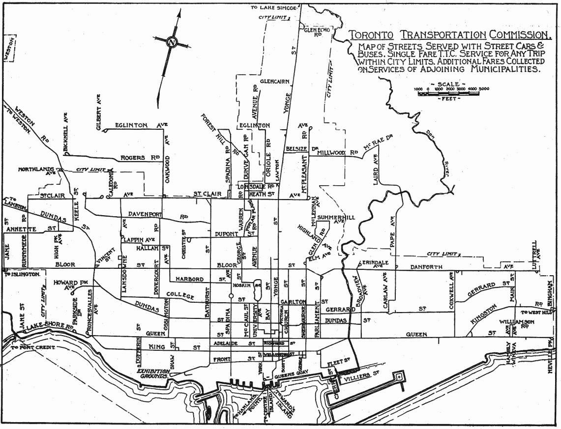
The following map shows TTC routes in August 1928. It was scanned by Pete Coulman from a guidebook, and the original scan lives on the TransitToronto website’s maps page.

ttc-map-1928-08-22

Only a few routes on this map are bus operations, generally small lines on the periphery of the system.

Serving Downtown

Anyone born in the past half-century is used to the idea that the Yonge-University and Bloor-Danforth subways (now known as Lines 1 and 2 respectively) provide the lion’s share of transit capacity into the core area, supplemented by the streetcar network and GO Transit. However, before the subways opened, their role was provided not just by streetcars on their namesake streets, but on parallel routes that fed into a common area. This was an essential part of service design not simply to spread out the network through many neighbourhoods, but because all of the streetcars needed to serve the core could not fit onto one street.

“Downtown” was quite different from the area we think of today, and much of the development was concentrated south of Dundas with areas to the north more residential than commercial. Construction of Eaton’s College Street store began in 1928, and it was thought to be a huge risk building so far away from downtown. The building is much smaller than original plans because of the combined effect of its location and the recession.

The land around the port and the railway corridor was used mainly for industrial purposes, and the large workforce in these areas required a lot of transit service. This land is now home to tens of thousands as the condo boom recycles the old city and changes travel demands.

Services to downtown in 1928:

  • Bathurst cars ran south from Vaughan Loop at St. Clair to Front, then east to Frederick Loop at Sherbourne Street. (Although there was track linking Bathurst to the Exhibition ground, it was used only during special events such as the CNE or Royal Winter Fair.)
  • Bathurst trippers (peak period cars) ran from Caledonia Loop on St. Clair east to Vaughan/Bathurst, south to Adelaide and then east to Church.
  • Bay cars ran from Caledonia Loop on St. Clair east to Avenue Road, then south to Bloor, east to Bay and south to Ferry Loop (York & Queens Quay where the circular ramp from the Gardiner is today).
  • Beach cars ran between Neville Loop on Queen to Sunnyside Loop west of Roncesvalles. Today the route is 501 Queen.
  • Beach trippers ran from Neville Loop to King & Bay looping via Bay, Wellington and Sherbourne. Today’s 503 Kingston Road Tripper is a descendant of this route.
  • Queen cars ran initially from Bingham Loop on Kingston Road (still in use by routes 502, 503 and 12) looping downtown via Victoria, Richmond and York. During 1928, service was extended east to Birchmount Loop, but streetcar service was cut back to the City of Toronto boundary in 1954 with the creation of “Metro Toronto”. Today’s 502 Downtowner is a descendent of this route.
  • Bloor cars ran between Luttrell Loop (between Dawes Road and Victoria Park on Danforth) and Jane Loop (south side of Bloor opposite the foot of Jane Street).
  • Danforth trippers ran from Luttrell Loop west to Church & Bloor, then south to Queen looping via Queen, York and Richmond.
  • Carlton cars ran between Luttrell Loop and High Park over almost the same route as today’s 506 Carlton. College Street ended at Lansdowne, and so streetcars jogged south to Dundas to continue their trip west.
  • Carlton tripper cars followed the east end route to Parliament, then jogged south to Dundas and west to loop via Victoria, Adelaide and Church.
  • Church cars began at Christie Loop (corner of Dupont & Christie) and ran east via Dupont, Avenue Road and Bloor to Church, then south to loop via Front, Yonge and Wellington.
  • College cars took a rather scenic route from Royce Loop (southeast corner of what is now Lansdowne & Dupont, formerly Royce Street) via Lansdowne, College, Bay, Dundas, Broadview, Gerrard, Carlaw, Riverdale and Pape to Lipton Loop (current site of Pape Station).
  • Harbord cars also originated at Royce Loop, but took a different route into downtown via Lansdowne, Lappin, Dufferin, Hallam, Ossington, Harbord, Spadina and Adelaide to Church looping via Richmond and Victoria. Sunday service followed much of the College route from downtown to Lipton Loop. This evolved eventually into a consolidated Harbord route which was its form until 1966 when the BD subway opened.
  • College trippers ran from Royce Loop to College and McCaul where they turned south and then east to York looping via Richmond, Bay and Adelaide.
  • Dovercourt cars ran from Townsley Loop at St. Clair & Old Weston Road (the loop still exists as the western terminus of 127 Davenport) then later in 1928 from Prescott Loop (a small parkette west of the railway at Caledonia). They operated via Old Weston, Davenport, Dovercourt, College, Ossington, Queen, Shaw to loop via Adelaide, Crawford and King. This route served the Massey-Ferguson industrial district which is now the eastern part of Liberty Village. Peak period service extended via King looping via Church, Front and George Streets. The most substantial remnant of the Dovercourt car is the 63 Ossington bus which was once operated with trolley coaches taking advantage of the electrical system already in place.
  • Dovercourt Trippers originated at Davenport & Dovercourt (reversing using the wye at that location as there was no loop) and followed the main route to King & Church.
  • Dundas cars operated between Runnymede Loop (now the western terminus of 40 Junction) and City Hall Loop (from Bay via Louisa, James and Albert Streets). This route has operated through to Broadview Station (now as the 505) ever since part of City Hall Loop disappeared under the Eaton Centre development.
  • King cars operated over essentially the same route as they do today between Vincent Loop (across the street from Dundas West Station) and Erindale Loop (one block north of Broadview Station). Peak service was extended in the west to Jane Loop and in the east to Danforth & Coxwell with some trippers looping downtown via Sherbourne, Front and Bay.
  • Parliament cars ran from Viaduct Loop (now a parkette at Bloor & Parliament) south to Queen then west to loop via Church, Richmond and Victoria.
  • Sherbourne cars ran from Rosedale Loop (at Rachael Street) south to King and then west to York and Front to Station Loop (Simcoe, Station and York Streets). Peak service operated east to Danforth & Coxwell rather than to Rosedale Loop.
  • Spadina operated with double-end cars between crossovers at Bloor and Front.
  • Yonge cars operated between Glen Echo Loop (east side of Yonge, just before the hill down to Hogg’s Hollow, the originally proposed name for York Mills Station) and Station Loop. Short turn services operated as far north as Lawton Loop (now a parkette on the west side of Yonge north of Heath Street) and AM peak trippers originated at Eglinton Carhouse (of which parts remain in the bus garage now recycled into a “temporary” bus terminal).

This is a huge number of routes that collectively linked the commercial and industrial core of Toronto to the residential neighbourhoods, some of which were comparatively recent “suburbs”.

The level of service was equally impressive. In the table below, numbers under “Two-Car Trains” give the number of trains (a motor car plus a trailer) operated followed by the total number of runs so that, for example, the Beach car has 44 runs of which 37 operated with trailers.

Route                 PM Peak      Two-Car
                      Headway      Trains

Bathurst                2'00"        3/30
Bathurst Tripper        5'00"        9/14
Bay                     1'15"
Beach                   2'30"        37/44
Beach Tripper           3'00"
Bloor                   3'00"        All 41
Carlton                 3'00"
Carlton Tripper         4'00"        14/17
Church                  4'00"
College                 4'00"        2/23
College Tripper         7'00"
Danforth Tripper        7'30"        7/10
Dovercourt              2'45"
Dovercourt Tripper      4'00"
Dundas                  2'00"
Harbord                 2'30"
King                    2'00"        31/54
King Rush               4'00"
Parliament              3'00"
Queen                   5'00"        16/17
Queen Tripper           5'00"
Sherbourne Tripper      2'45"        10/26
Spadina                 2'45"
Yonge                   1'45"        All 42

The West End and Suburbs

In addition to many routes listed above, a few were entirely “local” to their areas, and others were part of separate suburban network, the lines called “radials” that had been built separately from the “city” system.

  • The Davenport route was a remnant of a longer route on the Toronto Suburban Railway, but by 1928 was reduced to operating a shuttle service from Bathurst to Dovercourt. It survived until 1940 when it was replaced by a bus.
  • Lansdowne operated as two separate routes because of the railway level crossing (now an underpass) north of Dupont (Royce). The Lansdowne North route operated as a shuttle from St. Clair to the north side of the railway. Service from Royce Loop southward was provided by the College car weekdays and Saturdays, but there was a Lansdowne South Sunday service from Royce Loop to Dundas.

The TTC operated routes for York Township under contract.

  • Oakwood cars operated from Oakwood Loop at St. Clair (still existing) north to Eglinton and west to Gilbert Loop (west of Caledonia Road).
  • Rogers Road cars also operated from Oakwood Loop north to Rogers and west to Bicknell Loop (east of Weston Road).
  • Lambton cars, a remnant of the Toronto Suburban Railway, operated from Runnymede Loop west to Lambton Park. The line did not carry well, and it was converted to a bus route in August 1928.
  • Weston Road cars operated from Keele & Dundas north to Humber Street in Weston. This was another TSR line that originally had operated to Woodbridge (1914-1926). The line was converted to TTC gauge in stages, and for a time ended at a loop at Northland Avenue (at the City limits).

The Oakwood and Rogers routes eventually became trolley coach lines as part of what is now 63 Ossington, although Rogers Road has been extended and split off from Ossington for many years. The Weston Road route also became a trolley coach, although streetcar service remained as a peak-only extension of St. Clair until 1966. That extension was not possible until the opening of the “St. Clair Subway” under the Weston rail corridor in 1932, and the streetcars originally operated to Northland Loop. That is the reason why St. Clair cars were signed “Northland” even after they were extended to Avon Loop at Rogers Road.

Another leftover from the radial system was the line on Lake Shore Boulevard West.

  • Mimico cars operated from Roncesvalles Carhouse via the old trackage on Lake Shore (pre-Gardiner Expressway) west to Stavebank Road, just east of the Credit River in Port Credit. In the fall of 1928, the city trackage was extended to Long Branch, and the “Mimico” route disappeared. “Port Credit” cars ran on the remaining “radial” line until February 1935.

Updated: I have been remiss when listing routes operating in 1928 by omitting the Toronto Suburban’s line to Guelph. This was not a TTC operation, but remained part of CN’s electric operations to the end.

The line began at Keele & St. Clair, but was abandoned in 1931. This electric railway was never extended into downtown and suffered from its “suburban” nature even though its terminus was on the CN corridor now used by GO’s Kitchener-Waterloo service. The small station building remained for decades after. A fragment of the line still sees streetcar operation as the Halton County Radial Railway museum.

The East End and Suburbs

Most of the services in the east end ran to the downtown area and they are included in the main list above.

  • Coxwell cars shuttled between Danforth and Queen with Sunday/Holiday service extended via Queen and Kingston Road to Bingham Loop. This route exists almost unchanged today.

Service on Kingston Road east of Victoria Park was provided by the Scarboro radial car to a point east of Morningside Avenue where Kingston Road and Old Kingston Road diverge today. In late 1928, the line was double-tracked to Birchmount, the city routes were extended into Scarborough and the radial service operated from there east. Rail service ended in two stages: east of Scarborough Post Office in 1930, and the rest of the line in 1936 to allow highway widening.

The North End and Suburbs

The northernmost of the remaining streetcar lines is on St. Clair. In 1928, it operated from Caledonia Loop to Mt. Pleasant Loop at Eglinton, although service on St. Clair was also provided by the Bay and Bathurst cars west to Caledonia (see above). Eventually, the line was extended west to Keele Loop (replaced now by Gunn’s Loop) when the underpasses at Caledonia (1931) and at Weston Road (1932) opened. Caledonia and Prescott Loops were no longer needed.

By far the most extensive of the radial lines was the Metropolitan Division of the Toronto & York Radial Railway. This was not taken over by the TTC until 1927. Cars ran from Glen Echo Terminal north to Richmond Hill and Lake Simcoe with the line ending in Sutton. Service operated every 15-20 minutes during peak periods to/from Richmond Hill with some cars running through to Newmarket every 45-60 minutes all day. Cars to and from Sutton operated every two hours or so leaving from Sutton between 5:50 am and 10:25 pm with a running time of 2 hours and 25 minutes. The Lake Simcoe route was cut back to Richmond Hill in 1930.

College & Bathurst Construction

The reconstruction of College & Bathurst began on June 20, and is expected to continue for three weeks. This will involve both the full replacement of trackwork as well as other road and watermain works. The eastbound safety island will be removed because there is not sufficient space to expand it for accessibility requirements. The westbound island will be rebuilt and expanded.

The originally announced diversion for the 506 Carlton service operating with streetcars for the east end of the route was a loop clockwise via Bay, Dundas and McCaul. This has been revised so that 506 cars now run south on Parliament from Gerrard to Queen, and then west to McCaul Loop. The meet between 506 streetcars and buses is at Parliament.

This change is required because of construction at Bay to remove the two existing safety islands. Whether the route will revert to the original loop once it is physically possible remains to be seen.

Construction photos will be added here as the work progresses.

June 22, 2016

June 26, 2016

Cherry Street Day One

The first day of revenue service was beautiful and warm, ideal for tourists and photographers, although service on the 514 Cherry was quite spotty at times with cars running bunched and off schedule.

For anyone trying to find a 514, there was the added challenge that the TTC export to NextBus has not been set up correctly, and the “main” route appears to be from Queen and Broadview to Dufferin Loop with a spur down Cherry Street. This fouls up predictions for stops on the “spur”, and the clever rider must know enough to look nearby on King to see when a car might show up. Then there is the small matter of the claim that the car goes to “Cherry Beach” which I mentioned in yesterday’s post.

An additional issue was the absence of a low floor car among the five scheduled vehicles, although 4421 was running as an extra all day. The problem appears to be that the TTC neglected to flag crews for this route as requiring Flexity training, and so the operators generally can only drive the older high-floor cars. With 4421 running as an extra, it does not appear on NextBus and anyone needing an accesible vehicle faces an indeterminate, long wait while the car makes its 80 minute round trip. This extra will also be crewed with operators on overtime, rather than as a piece of work integrated into the normal schedule.

Yes, we all know there are not yet enough Flexitys to flesh out all of the service, but like 509 Harbourfront, the 514 could be operated with a few cars sprinkled in (well spaced, please) between the CLRVs as a first step. The TTC made a big point of flagging this as a new accessible service, but have been back peddling saying “when we get more new cars”. That’s not what Chair Josh Colle said in the press release two days ago:

“The 514 Cherry Streetcar will reduce congestion and provide more frequent service along the central section of TTC’s busiest surface route, the 504 King. The new route will be served by the low-floor streetcars, which will provide a more comfortable experience for our customers, and add a new east-west accessible route.” – TTC Chair Josh Colle

4421 was the first car out of Dufferin Loop providing an early trip at about 7:30 am, while 4044 was the first car from Distillery Loop at 7:45.

Another aspect of the route that is not working is the “transit priority” part of the signal system. Yes, there are transit signals, but they cycle through whether a streetcar is anywhere in sight or not. This is particularly annoying at King & Sumach which is a multi-phase signal that now includes eastbound and northbound “white bar” call ons for streetcars. These operate whether they are needed or not, and steal green time that could be used for King Street itself where the 504 cars spend considerable time awaiting their signals.

Although the TTC took several stops served by the 514 (and 504) out of service on June 19, they did little to flag this situation at the stops. Old pole cards, some falling off or visible only from one direction of approach, were all that told people the stops were not in service. The usual TTC signs for out of service stops, so commonly seen for construction projects and diversions, were nowhere to be found, and many riders were waiting at the stops (which were served by considerate operators). Some of the streetcars continue to announce these stops, and they remain in the stop list on NextBus and on the TTC’s schedule pages.

Finally, the shelters installed on Cherry Street are of a smaller type that was supposed to have been discontinued as they provide no “shelter” at all. An example is in the photo at Front Street below beside the former Canary Restaurant.

A lot of this may seem like small change, but collectively there is a lack of attention to detail especially on a new route’s launch where current, accurate info should be the easiest to provide. These are the details that annoy riders because the system and its “customer service” cannot be relied on.

The line is quite photogenic, and the real shame is that there is so little of it. When or if the planned Waterfront East streetcar and the link of Cherry under the rail corridor and into the Port Lands will happen is anyone’s guess.

Finally, there has been some discussion on Twitter about the absence of a stop northbound on Sumach at King. The reason for this is evident when one looks at a Flexity sitting where the stop should be: the sidewalk lip is some distance from the car and does not provide the sort of platform one would expect. This creates a safety hazard were this used as a stop, and probably interferes with operation of the wheelchair ramp. In the absence of a stop (and without a sympathetic operator), north to eastbound transfers (514 to 504) must be made at the next stop west on King at Sackville. This is not the most intuitive arrangement for riders, and the configuration of the sidewalk at Sumach should be corrected as soon as possible.

Kvetching About 512 St. Clair

The opponents of the 512 St. Clair streetcar right-of-way don’t miss any opportunity to slag the line. The TTC doesn’t help when it does not fully explain what is going on with this summer’s construction projects, and paints the work primarily as “accessibility” and “new streetcar” related.

A common complaint in Toronto is that nobody co-ordinates construction projects. Well, for those who bother to pay attention to the announcements of such things, co-ordination on a large scale is happening, and St. Clair is part of it. Many projects fit together like a jigsaw puzzle this summer.

  • St. Clair Station bus and streetcar loops require structural repairs that will take from now until late in the year. This has nothing to do with accessibility (the station already is accessible), nor with overhead changes for new streetcars (new pantograph-friendly overhead has been in place since 2011).
  • The ramps leading into St. Clair West Station Loop were not rebuilt during the line’s shutdown a few years ago (this is the only part that was, for some reason, omitted). They are the original installation from the Spadina subway opening and require reconstruction.
  • St. Clair West Station is not accessible, and work on this will begin this summer. However, that has nothing to do with the shutdown for all bus and streetcar routes serving the loop.
  • The overhead within St. Clair West Station must be converted for pantograph operation, but this is work that would typically be done overnight, or at most over a weekend.
  • Presto conversion of St. Clair West Station can be conveniently done while the station is closed, but did not strictly require it.
  • Reconstruction of small sections of the islands on St. Clair is required for proper operation of the low floor cars’ boarding ramps, but these island also require electrical fit-outs for Presto. This work is similar to that was done on Spadina.
  • Track construction at College & Bathurst prevents streetcar operation including access to St. Clair (although if this were the only issue, it would be handled by storing cars at Hillcrest or on the line as has been done in the past). The controlling factor is the ramp construction at St. Clair West. The Bathurst trackage will re-open in mid-July.
  • Work on College Street West by Toronto Water and as part of local street improvements for the BIA requires partial street closures. This has been co-ordinated with TTC trackwork at Bathurst and at Lansdowne.

In all of this, if one wants to knock the TTC, one might ask “why were the islands not done sooner” and “why were the ramps at St. Clair West left so long”. As for the islands, that’s partly a head-scratcher for accessibility, but Presto is a net new requirement. I suspect that the work could be done in under two months, but co-ordination with the other projects makes for one shutdown, not two. The ramps are another matter, and I have never heard an explanation of why this work was not done during the previous shutdown.

As for the replacement bus service running in mixed traffic, yes, that is going to be annoying. TTC does not want to use the streetcar right-of-way understandably because of narrow clearances with the overhead poles and the meandering path the lanes take. Those poles (notably absent on Spadina) were put in despite many questions to the TTC (including from emergency services) about the need for this design. What was really happening was that there was a boffin in the consulting firm working on the new streetscape who wanted the street lighting poles (which traditionally held up the TTC’s overhead) to be spaced further apart than TTC requirements. In the fullness of time, this wasn’t how the street was built (because the illumination level would not have been adequate), but meanwhile the TTC insisted on its own centre median poles except where buses share the right-of-way west of Bathurst.

It wasn’t a technical requirement, it was the combined stupidity of the street designer and the TTC’s sticking with a design that they no longer required. The result we have is a streetcar right-of-way that cannot host temporary bus service.

There is a lot to complain about with the TTC, and I am often criticized for writing more about the negatives than the positives. However, this is a case where a great deal of work has been collected into one set of shutdowns, and that is precisely the sort of thing the TTC and City should be doing.