This article is a follow-up to Ontario Line Design Changes Again including material from a new Metrolinx blog post.
As previously reported, Metrolinx has changed the track configuration between Corktown and Gerrard Stations on the Ontario Line so that both OL tracks are on the same side (north/west) of the rail corridor rather than straddling the four-track GO corridor.
When the Ontario Line was announced with much fanfare, a great deal was made by Metrolinx of the across-the-platform transfer connections possible at both Exhibition and East Harbour Stations with the GO Lakeshore corridor. The explicit benefit was to offload of GO/TTC transfer traffic from Union Station.
This design fell off the table (quietly) last year at Exhibition Station, but until quite recently, it was still advanced as the rationale for the OL’s configuration in this segment.
Now it too has disappeared and both OL tracks will be on the same side of the corridor. This actually makes life easier for Metrolinx designers including:
only one shared centre platform rather than two would be needed at stations, and only one set of vertical accesses (stairs, escalators, elevators);
electrification of GO will be relatively isolated from that for the OL which will run on a different voltage and probably a different height of overhead above the rails;
only one bridge rather than two will be required to carry the OL across the Don River;
only one tunnel portal will be required at Gerrard rather than two;
no tunnels under the rail corridor will be required to shift the eastbound OL first to the south side at East Harbour and then back to the north side at Gerrard;
there is room at East Harbour for platforms for all four GO tracks, not just the two outer ones, permitting this to be an express and local station as befits its location at a major development node.
Considering that Metrolinx is all about building projects more efficiently, one has to wonder why they didn’t pursue this configuration from the outset unless that cross-platform transfer was a holy grail untouchable until now.
The change is promoted as the result of listening to the community where more than a little opposition to the OL came from its intrusiveness and potential effect on buildings and open spaces. Until quite recently, Metrolinx defended their original design against all criticism.
Their tune has changed:
Re-positioning Ontario Line tracks at East Harbour means all Lakeshore East and Stouffville GO train services can stop at the station – something that wasn’t possible with the previous design. With a shared concourse providing easy access to all of the rail services that will serve East Harbour, more customers will be able to transfer between more trains, and travel to more places.
Customers who will be boarding the stations at Queen and De Grassi and at Gerrard and Carlaw will also see more benefits because, no matter what entrance they use, they’ll arrive at a centre platform that serves trains in both directions. They won’t have to worry about getting to platform level just to realize their train is on the other side of the rail corridor, accessed through a different station building. This will create a simpler, more accessible experience for everyone who uses the station.
[…]
But the improvements to the track positioning means teams can cut down on the amount of station buildings needed as well, which means even fewer impacts to the parks that have been developed around the active rail corridor over the years.
The line now occupies slightly less space than before, although the diagrams above are not engineering drawings showing the exact scope of work before and after the redesign.
Metrolinx is still silent on the need for or absence of crash walls between the GO rails, the Ontario Line and nearby buildings. These would add to the total width of the corridor.
Metrolinx would do well to show more detail for their new plan all the way from the Don River to the portal(s) at Gerrard.
Another round of community consultation is planned in coming weeks.
This post is a departure from my usual reportage and takes us into the realm of “what would you do” advocacy.
The ongoing debate about Metrolinx’ proposed above ground route for the Ontario Line between East Harbour and Gerrard Stations turns on two issues:
The effect of a six-track wide shared GO+OL corridor on the neighbourhoods through which it will pass.
Whether the Ontario Line could be tunnelled.
The debate was recently clouded by a proposed shift in the OL’s alignment. Originally, the line would straddle the GO corridor in order to provide “across the platform” transfers with the outer two GO tracks at East Harbour. Metrolinx is now contemplating shifting both OL tracks to the north/west side of the corridor. This has several advantages as I discussed in a recent article, but it leaves the OL above ground.
The original configuration is shown below in a map from Metrolinx’ site. Note that North is at the right.
Putting the line underground on this alignment is very difficult because of constraints on the grade change between East Harbour and the (misnamed) Leslieville Station. Any descent is constrained by the cross-streets let alone the vertical difference between an East Harbour Station on the rail embankment and a Leslieville Station at Queen.
A neighbourhood group (The Lakeshore East Community Advisory Committee, aka LSE CAC) posed the question to me: is there a way to put the line underground? On the Metrolinx alignment, the simple answer is “no”, but that brings us to the question: why that alignment?
The original Relief Line would have crossed under the Don River on the line of Eastern Avenue with a station at Broadview as shown in the diagram below. The link with GO at East Harbour would not be as simple or direct as in the Metrolinx proposals where the OL and GO tracks and platforms are adjacent.
Metrolinx seeks to offload GO traffic from Union Station and sees transfers to the OL at East Harbour and Exhibition as a solution. However, changes to the planned layout at both stations have stripped the simple across-the-platform transfer for peak directions from their designs.
At Exhibition, only the westbound service would connect with the south side of the terminal station platform. Inbound (eastbound) GO riders would have to access the OL via an underpass. At East Harbour, if the alignment shifts to the north side of the station, the westbound GO track would be adjacent to the eastbound OL track, and there would be no direct link to the eastbound GO platform.
Metrolinx now describes the connections as more convenient rather than direct, but the attraction of a simple transfer to shift traffic has disappeared.
An alternative scheme, which I developed before Metrolinx plan to shift the OL to the west/north side of the rail corridor, uses the proposed eastbound tunnel under the rail corridor as its starting point. Instead of carrying just the eastbound track, it would house both directions, and they would cross the Don River on a dual track bridge south of GO’s trackage where a single eastbound bridge was proposed by Metrolinx.
A shared platform at East Harbour would be oriented to be as far west as possible and only one OL train length (not the full size of a GO platform). The east end of the platform (and hence the point where a descent underground could begin) is dictated by the proposed Broadview extension which would pass under East Harbour Station.
From that point, the line would turn east and descend through what is now largely vacant land and a laneway behind a heritage buildings on Eastern Avenue.
East of Booth Avenue, the line would swing north and join the original Relief Line alignment east of Logan.
The illustration below was prepared by the LSE CAC based on my proposal.
Courtesy of “Save Jimmy Simpson” / Paul Young
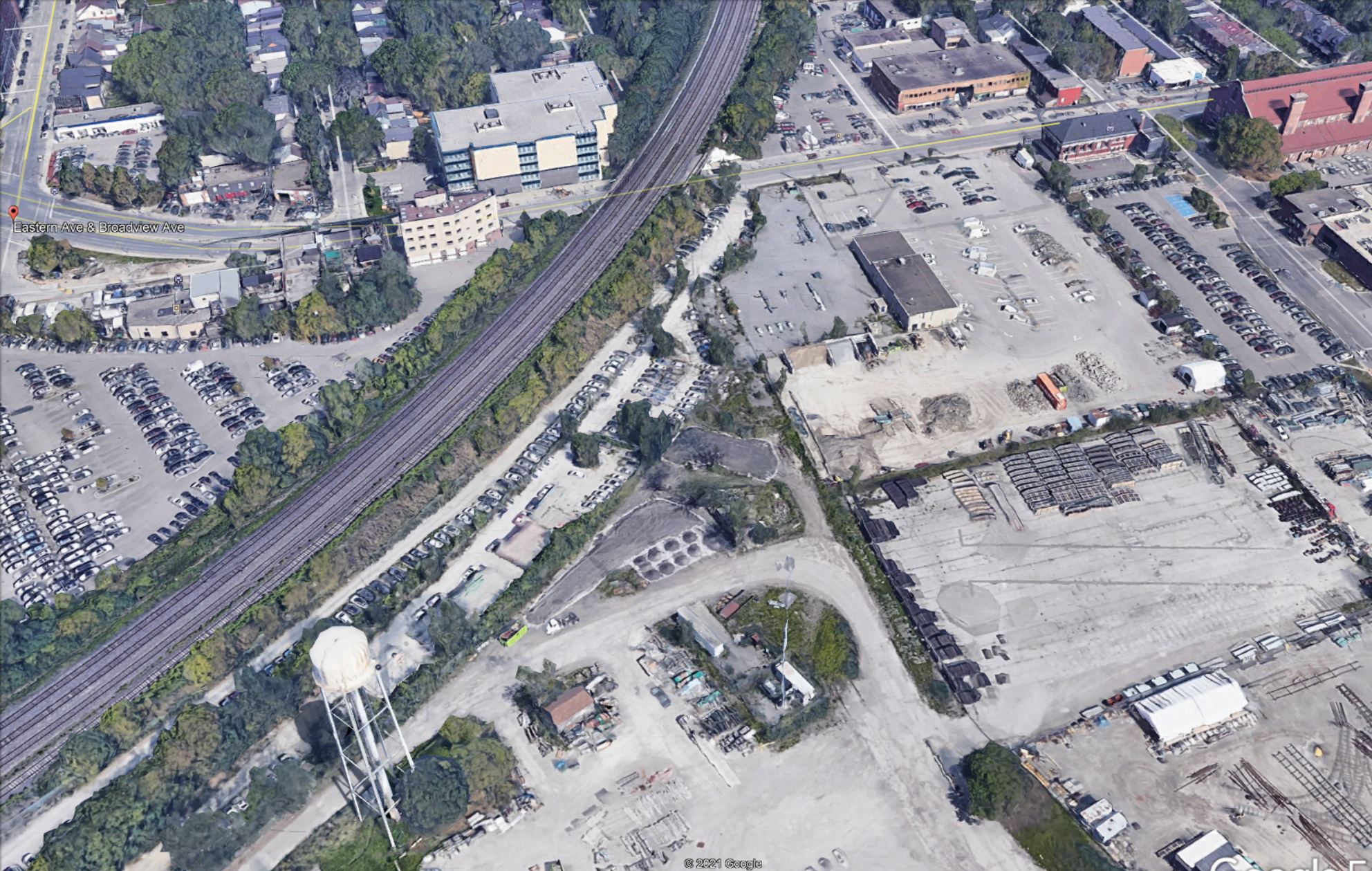
Here is the west end of this area. For reference, the Broadview Extension will cross just west (left) of the water tower (which is to be retained as a landmark in the new development here).
Source: Google Earth
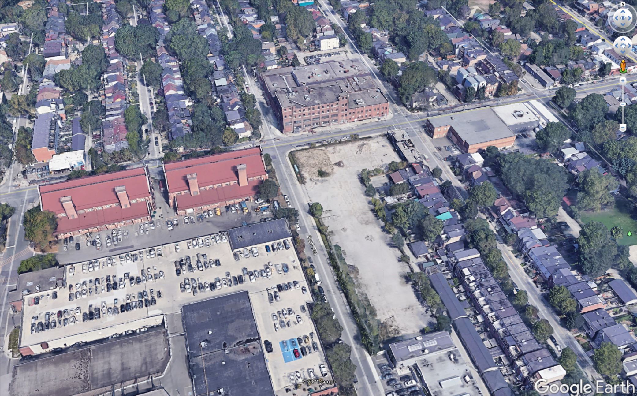
Here is the east end of the area. Note that the vacant lot on the south-east corner at Booth and Eastern in this photo is now occupied by a self-storage building that would have to be removed.
Source: Google Earth
I have no illusions that this would be an easy alignment, but it has advantages over attempting to fit the Metrolinx route under ground:
The transition from above grade to underground would occur in largely vacant land and before the line must cross a major street (Eastern), preferably west of Booth so that this street would remain open.
The Leslieville Station is far enough from East Harbour that it does not constrain the vertical alignment in the same manner as the station would at Queen & Degrassi.
Potential issues include:
The City has plans for this land in the East Harbour development and they would have to be revised to accommodate the ramp and portal structure for the Ontario Line.
The OL structure would be close to the surface continuing its descent to Carlaw. This could affect utilities where the alignment crosses Booth, Eastern and Logan, as well as some properties along the curve between Eastern and Carlaw.
It is self-evident that an underground route from East Harbour to Gerrard will be more expensive than the Metrolinx proposal along the rail corridor.
Very bluntly, I could be more sympathetic to this issue if Metrolinx were not already pursuing underground options in Scarborough and on Eglinton West at great expense for blatantly political reasons.
Updated March 27, 2021: The reference to third rail power pickup for the Ontario Line was incorrect and has been changed. According to the December 2020 Preliminary Design Business Case the line will use 1500V DC overhead power supply.
As originally announced, the Ontario Line was intended to run along the GO Lake Shore East corridor between the Don River and Gerrard Street with the new rapid transit tracks straddling the GO transit line as shown in the map below.
Discussions with the Riverside and Leslieville neighbourhood have been fraught with concerns about the combined effect of the two new Ontario Line tracks, the stations, the expanded four-track GO corridor and the infrastructure needed for electrification. This has been the subject of previous articles and I will not rehash the issues here.
At a community meeting on March 25, 2021, an unexpected piece of news was revealed not by Metrolinx staff, but by City Councillor Paula Fletcher: Metrolinx has changed the design so that the Ontario Line tracks will run on the west side of the GO corridor.
I asked Metrolinx for their comment, and here is their reply:
As part of our planning, we have been exploring alternatives that will allow us to incorporate some of the feedback from the community. The updated plans are not yet final so it is too early to provide details or images.
One thing we are looking at is shifting both Ontario Line tracks to the west side in the corridor, rather than on either side of the GO tracks.
Once finalized, we will be sharing the updated plans related to the configuration with the community in the coming weeks at a public consultation.
We are still conducting environmental assessments for the area, which include a Joint Corridor Early Works Report and an Environmental Impact Assessment Report for the whole line.
Email from Metrolinx Media Relations, March 26, 2021
This has many implications including the total space needed for the six-track corridor, the placement of electrification infrastructure, the effect of stations on their neighbourhoods, and transfer provisions at the key East Harbour Station.
From a construction point of view there are benefits to keeping the OL tracks together:
There is no longer any need to tunnel under the rail corridor so that the eastbound track can reach its position south-east of East Harbour Station, nor to tunnel again for the tracks to rejoin at Gerrard before heading up Pape.
Only a single shared bridge over the Don River will be needed.
The two directions of the OL can share a centre platform rather than requiring dedicated platforms, including access elements like escalators and elevators.
Structures for GO can be better separated from those for the OL which will now lie beside the GO tracks, not astride them.
Construction of the OL should have less effect on the adjacent GO operations.
The possible downsides or side-effects include:
The consolidated eastbound and westbound platforms and station structures are now all on one side of the GO corridor possibly affecting areas and buildings that were previously outside of the construction area.
The minimum clearances for GO electrification will have a greater effect on the east side of the corridor because the eastbound OL track will no longer provide some of the separation needed from nearby buildings and vegetation.
The claimed benefit of across-the-platform transfer between GO and OL services at East Harbour is now reduced. All transfers will have to go down to a concourse level to switch between trains.
At the March 25 Metrolinx Board meeting, management presented an overview of the Ontario Line and the benefits of above ground construction. This alignment change was not mentioned at all. Notable by its absence was any reference to the convenience of across-the-platform transfers, a major selling point for the OL as a potential way to offload demand from Union Station.
When originally announced, the Ontario Line would provide across-the-platform transfers with GO at both East Harbour and Exhibition Stations to redirect some GO traffic to the OL and offload Union Station. At Exhibition, this design has already proved to be impractical and the OL station will be entirely north of the rail corridor. We appear to be on the verge of seeing a comparable change at East Harbour. This was a major selling point for the OL design.
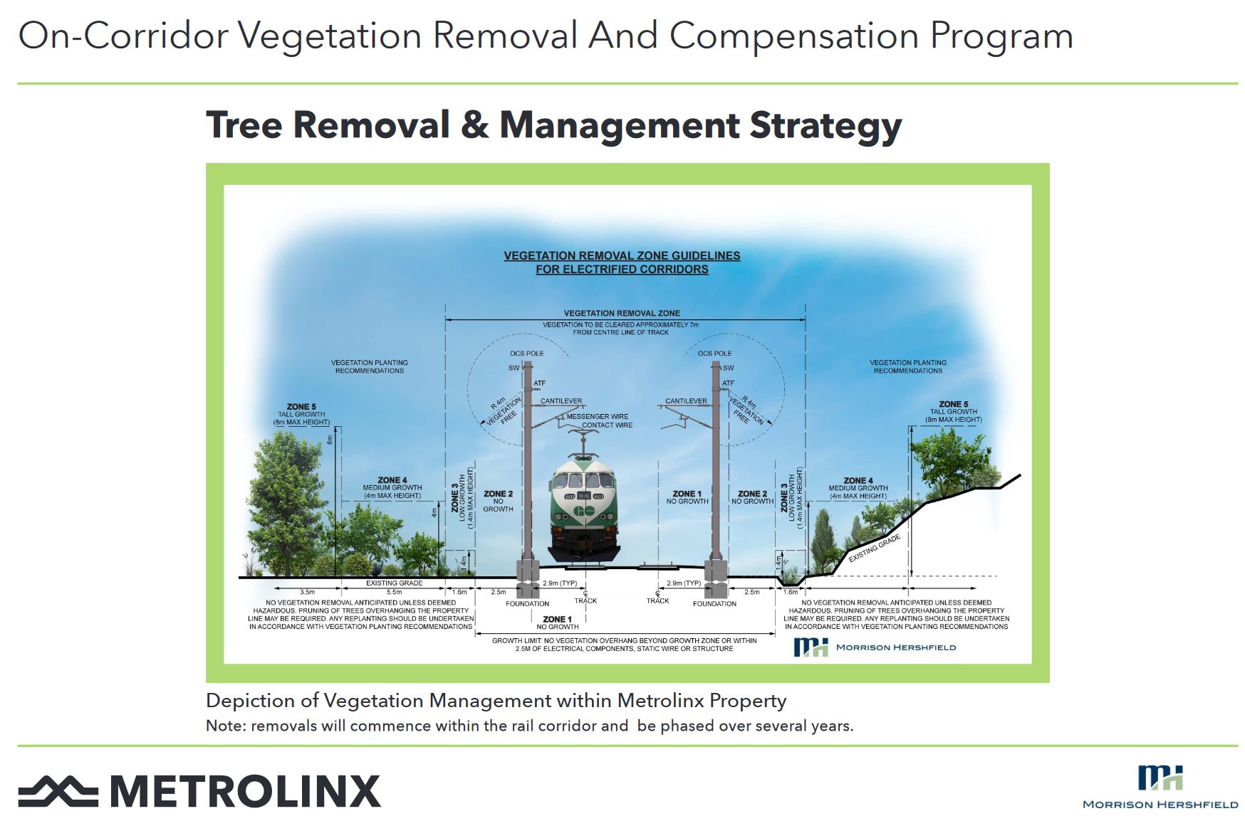
As I discussed in a previous article, aspects of that presentation put a better spin on Metrolinx plans than might actually be deserved. With the change in the track layout, a further issue pops up: the proximity of buildings or vegetation to the electrified GO trackage.
Here is a diagram showing the minimum clearances from adjacent vegetation (mainly trees) on an electrified GO corridor:
In a context where buildings are nearby, the diagram changes a bit, but the basics are similar.
These drawings show a two-track GO corridor, but Lake Shore East will have four tracks, plus the Ontario line tracks. If this view looked northeast, the OL tracks would be on the left side, probably to the left of the pole holding the overhead system.
In that configuration, the “no vegetation” zone to the left (west/north) would be occupied by the OL itself which should have much less restrictive requirements for nearby growth because it uses overhead power at a much lower voltage than GO trains. However, on the right (east/south), the outermost GO track is now at the edge of the corridor and clearance requirements for electrification apply. [Corrected March 28/21 to reflect overhead rather than third rail power supply.]
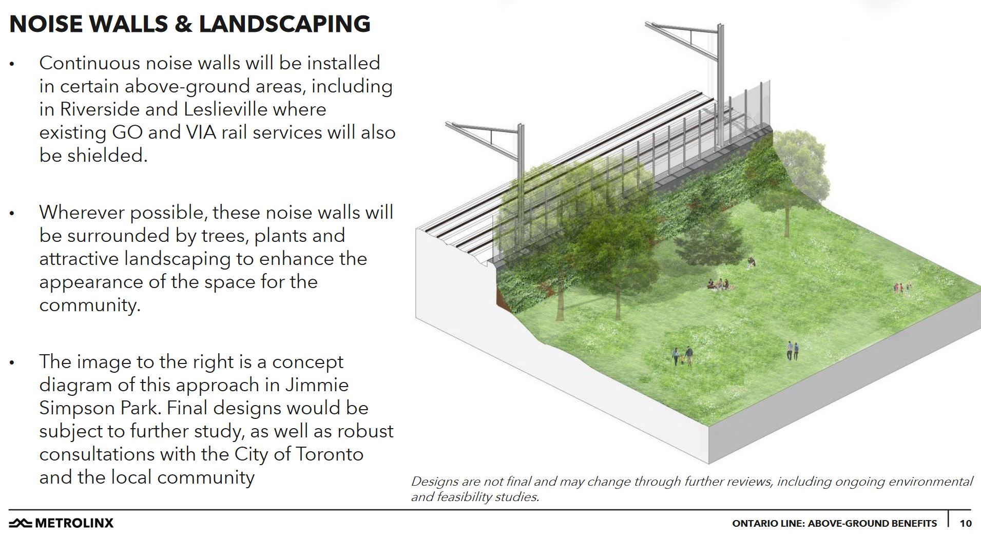
An illustration of a park on the line must be seen in this light. This shows a mature tree immediately beside the sound wall and the overhead support poles. As shown, it is within the clear zone required for electrification.
In the management presentation, Metrolinx claimed that the Ontario Line will actually make the neighbourhood quieter, although they did not explicitly say “quieter than today”. This is something of a stretch because there will still be more GO trains, and many of them (thanks to the Bowmanville extension of GO service) may well be diesel.
This is an example of a fundamental problem with Metrolinx planning for this corridor: they conduct separate studies and community sessions for the Ontario Line and for the GO Expansion and Electrification program rather than producing a consolidated plan showing the effect of all three changes planned over the coming decade.
A further exaggeration, intended to show how all of this work has a beneficial end even though it might affect the community, lies in claims of environmental and congestion benefits of the project (regardless of its alignment).
All of the new transit riders on the Ontario Line are assumed to represent avoided auto trips complete with their congestion and pollution. There is no guarantee that fewer auto trips will be taken in the future due to a backlog of demand for road space, and due to population growth.
A common remark Metrolinx has made about The Big Move regional plan is that it will at best keep things from getting worse. In areas where there is already heavy traffic and congestion, it is not realistic to assume that the day the OL opens, roads will suddenly empty of cars. This is a bogus position, and Metrolinx should know better.
The original Ontario Line scheme was sold on its benefits for GO interchange and because it was claimed to fit within existing Metrolinx lands, more or less. Gradually these claims are coming unglued, although many of the underlying issues were clear the day the line was announced.
Postscript: An Alternate Alignment from the Don River to Carlaw
In my previous article, I alluded to a possible alignment that would splice the Ontario Line into the Relief Line’s alignment running up Carlaw from Eastern. From East Harbour, the OL would have travelled east parallel to Eastern Avenue and descended below grade, then veer north to hook into the Relief Line route at about Logan Avenue.
This scheme depended on the Ontario Line being entirely on the south/east side of the rail corridor at East Harbour rather than astride it (as in the original OL plan) or on the north/west side as in the revised plan.
With the proposed shift of the Ontario Line to be entirely on the north/west side of the rail corridor, this scheme is no longer feasible.
The Metrolinx Board meeting on March 25, 2021, brought two contrasting views of “good” rapid transit projects to the fore exposing inconsistencies in the “official story” about building above or below ground.
On the Capital Projects front, many works ranging from LRT lines to GO upgrades are on the surface although, of course, the central portion of the Eglinton line is underground. Progress on the surface LRT lines is swift thanks to the avoidance of underground work and complex tunnel structures.
But at the end of the presentation, the “big news” is that prime bidders for both the Scarborough Subway and Eglinton West LRT tunnels have been selected and negotiations are underway on contract details. Some early works such as construction of the tunnel boring launch site at Sheppard/McCowan Station will begin in April.
The long history of debates about Scarborough’s transit network do not bear repeating. Suffice it to say that the underground option is oft touted as the only way to provide good transit, albeit at substantial cost.
According to a Metrolinx Blog article, the line will be tunneled in one bore from Sheppard south and west to Kennedy Station rather than in two separate bores meeting at Lawrence East. This simplifies some of the construction staging and eliminates the potential for major upheaval for Scarborough General Hospital at Lawrence & McCowan. The line will be a single bore 10.7m diameter tunnel according to the Board presentation by Matt Clark.
On Eglinton West, despite the availability of land for a surface LRT right-of-way and demand projections well within the capacity of surface operations, the line will be buried from the Humber River westward as dictated by Premier Doug Ford in his transit plan.
In both cases there will be fewer stations that would have existed with surface LRT options, and on Eglinton ridership projections are lower as a result. (Scarborough is a more complex case because one subway has been substituted for two, if not three LRT lines in a network.) Access time between surface and subway routes – a key item Metrolinx always mentions about its surface alignments – is not mentioned when they enthuse about coming tunnel construction.
At its February 10, 2021 meeting, the TTC Board receive a long report entitled Transit Network Expansion.
The raison-d’être for the report is to obtain the authorization to increase staffing by 34 positions that would be funded by Metrolinx, but would be part of the TTC’s stucture. Many aspects of projects underway by Metrolinx depend on TTC input and acceptance because they affect lines the TTC will operate and, at least partly, maintain. A new Transit Expansion Assurance Department within Engineering & Construction. The authorization include provision for temporary expansion beyond 34 should this be required.
This move is intriguing because it implies Metrolinx has accepted that it cannot build new lines completely on their own without TTC input, especially when they will operate as part of the TTC network.
The report also requests authorization for:
[…] the Chief Executive Officer, in consultation with the City Manager, City of Toronto where applicable, to negotiate a Master Agreement and/or other applicable Agreements with the Province and/or any other relevant provincial agency for the purposes of the planning, procurement, construction, operations, and maintenance of the Subway Program, in accordance with Board and City Council direction, and to report back to the Board on the results of such negotiations. [pp. 2-3]
There is a great deal more involved in building and operating transit projects than holding a press conference with little more than a nice map. Now comes the hard part of actually doing the work. Whether Metrolinx will negotiate in good faith remains to be seen, but the TTC and Toronto appear to be less willing to hide Metrolinx’ faults in light of the Presto screwups.
Another recommendation has a hint that all is not well with consultations, as that should be any surprise to those who deal regularly with Metrolinx.
Request Metrolinx to conduct meaningful engagement with the TTC’s Advisory Committee on Accessible Transit (ACAT) as part of the Project Specific Output Specification (PSOS) review and design review for all projects within the provincial programs. [p. 3]
The operative word here is “meaningful”. ACAT has already complained of difficulties with Metrolinx including such basics as poorly designed elevators on the Eglinton Crosstown line that cannot be “fixed” because they have already been ordered.
Right from the outset, the TTC claims to have a significant role, a very different situation from the days when Metrolinx claimed it would be easy for them to take over the subway system.
The TTC continues to play a key role in the planning, technical review, and implementation of all major transit expansion projects in Toronto and the region. These include the Toronto Light Rail Transit Program and the provincial priority subway projects, referred to collectively as the “Subways Program”: the Ontario Line; the Scarborough Subway Extension; the Yonge North Subway Extension; and the Eglinton Crosstown West Extension. [p. 1]
In support of the staffing request, the report goes into great detail on many projects:
Two projects are not listed among the group above, but there is a description buried in the section on Bloor-Yonge expansion.
Overall subway system capacity and service expansion
Any discussion of the Line 2 renewal project
There is no discussion at all about renewal and expansion of surface service. This is just as important as new lines, but it is not seen as “expansion” with the political interest and funding that brings. Yes, this is a “rapid transit” report, but the core network of subway lines dies without the surface feeder routes, and many trips do not lie conveniently along rapid transit corridors.
The map below shows the location of most of the projects, but there are some odd inclusions and omissions.
The RapidTO bus corridors are not included.
City-funded GO stations at St. Clair/Old Weston, Lansdowne, King/Liberty, East Harbour and Finch/Kennedy are shown.
GO funded stations at Woodbine Racetrack, Mount Dennis, Caledonia and Park Lawn are shown.
The planned improvement at between TTC’s Dundas West and GO’s Bloor station is not shown, nor is any potential link between Main and Danforth stations.
SmartTrack stations are shown, but there is no discussion of how GO or ST service would fit into the overall network.
The following two maps have attracted a lot of attention, although they do not tell the full story. Much as I am a streetcar/LRT advocate, the presence of the entire streetcar network here is misleading, especially in the absence of the RapidTO proposals. Some of the streetcar lines run in reserved lanes, although thanks to overly generous scheduling some of them are no faster than the mixed-traffic operations they replaced (notably St. Clair). However, most of these routes rank equivalently to the bus network in terms of transit priority. If we are going to show the streetcar lines, why not the 10-minute network of key bus route?
The map is also distorted by having different and uneven scales in both directions. The size of downtown is exaggerated while other areas are compressed.
For example, the distance from Queen to Bloor is, in reality, half that of Bloor to Eglinton and one quarter of Eglinton to Finch. It is also one quarter of the distance from Yonge west to Jane or east to Victoria Park. For comparison, the TTC System Map is to scale, and it shows the city in its actual rectangular form.
This map gives an impression of coverage, but masks the size of the gaps between routes as one moves away from the core. Bus riders know all about those gaps.
By 2031, the network is hoped to look something like this. No BRT proposals are shown, but we do see the waterfront extensions west to Dufferin, and east to Broadview (East Harbour). Also missing are the GO corridors which, by 2031, should have frequent service and (maybe) attractive fares. They are (or should be) as much a part of “Future Rapid Transit” as the TTC routes.
This map is trying to do too much and too little at the same time. It also reveals a quite selective view of “regional” transit.
I am not trying to argue for a map that shows every detail, but it should exist (a) in scale and (b) in formats with overlays showing major parts of the network and how they relate to the overall plan. When people concentrate on the pretty coloured lines, they tend to forget the other equally important parts of the network.
Metrolinx has launched another round of consultation for various projects that make up the GO Transit Expansion Plan. Information on these is scattered through various pages on their site.
There is an interactive map of locations where changes are proposed, although it can be tedious to navigate because the default map does not have street names. (You can change this by selecting a different base map from the options in the upper right of the display.)
This map shows roughly the location of the Ontario Line corridor, but gives no detail about extra space, although the map is not to be taken as definitive. Nothing is shown of potential stations for the OL, and there is no information at all in the map for the several proposed SmartTrack stations.
This means that the scope of the project review and the combined effect GO Expansion will have with other projects is not known. Moreover, it would be foolish to approve a project based on a spec that did not include two major additions that are somewhere in the Metrolinx pipeline.
Stations, be they for the Ontario Line or for GO/SmartTrack require platforms and circulation elements (stairs, elevators, roads) but there is no hint of the space these will take.
An ongoing problem for anyone attempting to work with Metrolinx on their projects is the lack of transparency, the fog through which details emerge, if at all, on what they actually propose to do.
Distrust of Metrolinx to deal fairly and honestly with communities and their political representatives led to widely-supported motions when Council considered two reports regarding Metrolinx projects on October 1, 2020:
Back in June 2020, I wrote about the gradual drift in the planned dates for various Metrolinx projects as reported by Infrastructure Ontario [IO for short].
The September 2020 Market Update has been issued by IO and it shows changes in some projects from the June update.
Sept 26, 2020: Revised to include the change in financing method for the OnCorr GO Corridor project.
Is The P3 Model Falling Apart?
Two revisions in the large GO project procurement model involve a change from private sector financing to traditional government borrowing.
This suggests that the market willingness to finance projects on behalf of the government, or at least to do so at rates competitive with direct government borrowing, may be on the wane. That implies that the “P3” model may be coming unglued.
At its heart, this was always seen as an accounting mechanism to shift debt off of the government’s books, and without this shell game, a major argument for P3s could vanish.
The Future of Electrification
The change in financing model could shift any decision on propulsion technology back to the government.
Metrolinx had pushed this off its plate by saying that the bidders who were going to design and operate a future GO network would make that choice. This punted the knotty political problem of hydrogen trains touted former Premier McGuinty out of Metrolinx itself.
Will Ontario be willing to finance the large up-front capital costs of electrification itself with so many other pressures on financial resources, or is electrification about to fall out of consideration while spending focuses on service expansion?
Ontario Line
The project is in three sections of which the last will be the “Northern Civil, Stations and Tunnel” which includes the portion of the line east of the Don River and north to Eglinton, but not the Maintenance Facility which is included with the “South Civil” portion as it is needed relatively early in the project.
Some of the work on the North section between the Don River and Gerrard Station might be undertaken as part of the GO Corridor improvements, but exactly what this might entail has not been made public.
Since the last update, there are three changes for the North section:
The date for RFQ (Request for Qualifications) issue has been changed from Winter to Spring 2022.
The RFP (Request for Proposals) issue has been changed from Spring 2022 to Fall 2022.
The Financial Close (in effect, the contract signing) has been changed from Fall 2023 to Spring 2024.
The remaining portions of the line are on the same timeline as before.
The timelines for this project, with financial close for the first two portions in fall 2022 and for the third in spring 2024 puts this beyond the next provincial election expected in mid 2022, the four-year anniversary of the Ford government’s election. Who will be in place to make final decisions, and what the government’s financial position will be by then, remain to be seen.
Line 2 East Extension (Scarborough Subway)
This project is now shown with two portions: one for the tunnel, and the other for the stations, railway and systems.
There is no change in the tunnel portion of the project, but the remaining portion has reverted to the dates shown for the overall project in the Winter 2020 update.
GO Expansion Lakeshore West Corridor
The financial close for this project has been changed from Winter 2021 to Spring 2021.
GO Expansion Lakeshore East-West Corridor
This was originally to have been a “Build-Finance” project, but it is now “Design-Bid-Build”, a change that was made in August 2020 according to the IO report.
GO OnCorr Projects
[Added to this article on September 26, 2020]
This is a very large project including future operation of GO Transit and possible changes in the propulsion technology.
The procurement model has been changed from “DBOFM” (Design-Build-Operate-Finance-Maintain) to “DBOM”. The proponent will no longer finance the project which has a projected value of over $10 billion.
All other projects are unchanged. A summary of the Metrolinx projects tracking their changing status is available in this spreadsheet (revised version).
October 6, 2020: This article has been updated with information on the north section of the Ontario Line between Danforth and Eglinton (Pape to Science Centre).
September 29, 2020: This article has been updated with information on the east section of the Ontario Line between the Don River and Danforth.
September 23, 2020: This article has been updated with information on the central section of the Ontario Line between Osgoode Station and the west side of the Don River.
I asked Metrolinx a series of questions about information released in the two “neighbourhood updates”:
1. The station boxes that are shown are barely 100m long. What provision will the stations include for ventilation shafts? Will they be within the platform area or will they be beyond the end of the platforms as on, for example, the Crosstown line?
2. There is only minimal discussion of entrance locations. Will the stations include two separate paths from platform to surface as per fire code?
3. Will there be emergency service buildings between the more widely spaced stations to provide egress in case of a tunnel fire?
4. There is reference to using the space for lower Queen station as part of the design, but this area is (a) fairly small and (b) already used for a variety of purposes. Is the intent to have the OL go beneath all of the existing structure with the actual track and platform below lower Queen and with the “ghost” station space (which is already used in part as a pedestrian underpass between northbound and southbound platforms) only used for circulation space between the two lines? That would make a lot more sense than actually trying to take OL trains through the existing lower Queen Station.
5. The diagram of the Don Yard shows a direct conflict between the structure for the westbound OL portal and the Richmond Hill GO corridor. What is happening here?
In response, Metrolinx issued the following rather opaque reply:
Metrolinx will factor in all necessary safety and accessibility requirements into the Ontario Line designs. The most recent update is a more detailed vision of the project, but more details are still to come.
Metrolinx will be closely coordinating any Ontario Line work alongside our existing rail operations to minimize or avoid service impacts, while also respecting concurrent GO Expansion work.
Email from Scott Money, Metrolinx Media Relations
The original article begins here:
On September 17, 2020, Metrolinx released the Draft Environmental Conditions Report [Draft ECR] for the Ontario Line.
A huge volume of material is included, thousands of pages, but the vast majority of this only documents existing conditions and gives little indication of the actual “environmental impact” that building and operating the Ontario Line will have.
For convenience, here are links to source materials. The Draft ECR link leads to a page with many documents, some of which are very large PDFs.
It is self-evident that the actual impact of any project cannot be known without the details of what will be built. This information is not yet public and only sample area maps which are drafts “for illustrative purposes only” have been released for a portion of the route. More will follow in coming weeks, but one must ask why they are not all available now if Metrolinx expects informed comment on their proposal.
Even on the supplied maps, many key features are missing including:
Vertical and horizontal alignment including property requirements for construction
Station sites, access and circulation plans including redundant paths between platforms and the surface for fire safety
Emergency service buildings and access structures to tunnels
Utility buildings such as substations
During the public consultation process and as recently as the April 2020 report summarizing this work, the project timeline was illustrated as below. This clearly shows that only one set of “Environmental Reports” were to be published and this was expected in Fall 2020, that is to say, now.
Source: Engagement Summary Report, April 2020, p. 43
Ontario changed the legislation relating to Environmental Assessments with the effect that the item of most interest — the actual design and effect of the project — will not be known until later in the process than the public originally expected.
As required under O. Reg. 341/20, Metrolinx is preparing an environmental conditions report, which will be published for public review and input prior to finalization. The report will characterize the environmental setting in the vicinity of the Ontario Line, including existing noise and vibration levels, air quality, natural environment features, built heritage and archaeological resources, socio-economic and land use features, and traffic conditions.
Metrolinx is also planning to publish early works reports for components of the Ontario Line project that are planned to proceed to implementation ahead of completion of the Ontario Line assessment process.The early works reports will assess the environmental impacts of the early works and describe associated mitigation measures. The early works reports will be published for public review and input prior to finalization.
Following finalization of early works reports, Metrolinx will publish an environmental impact assessment report, which will assess the environmental impacts of the Ontario Line and describe associated mitigation measures. The environmental impact assessment report will be published for public review and input prior to finalization,as part of Metrolinx’s effort to meet the best practices and community consultation principles that are part of the Environmental Assessment Act with all projects. This will be followed by early works reports and the Environmental Impact Assessment Report environmental impact evaluation results, mitigation measures, monitoring activities, potentially required permits and approvals and other components.
Source: Metrolinx Update to City of Toronto, p. 13
There are now three streams of reports and consultation. First up is the ECR which has just been issued, but separately there are reports on “Early Works” (design and construction that can get underway to advance the project before the full design is locked down) and then the “Environmental Impact Assessment Report”. It is only in the last report that the details of design and effects on neighbourhoods will be revealed, and this is planned for winter-spring 2021.
Source: Ontario Line Environment Page
On a parallel track, the procurement process is already underway with teams short-listed to bid on two major contracts:
Rolling Stock, Systems, Operations and Maintenance (RSSOM)
Southern Civil, Stations and Tunnel (Exhibition to Don Yard Portal)
The Northern Civil, Stations and Tunnel package (Don Yard Portal to Eglinton) will be tendered separately in 2022.
The ECR contains material reviewing conditions in a wide study area shown in the map below.
The study area is relatively wide in some areas, but narrower in others implying that a range of options was reviewed for parts of the route. Notable by its absence is the original Eastern-Pape corridor for the Relief Line showing that there was never any intention of entertaining this as an option, if only for comparative purposes.
The study area in Thorncliffe/Flemingdon is fairly large in part because this includes the proposed maintenance yard, but also because alternative routes through this area were under consideration.
Source: Draft Environmental Conditions Report, page i
Alignment plans are shown only for the western segment between Exhibition and Queen/Spadina at this point. Metrolinx plans to unveil details of additional segments on a weekly basis for other parts of the line:
Osgoode Station to Don Yard
East Harbour to Pape South
Pape North to Science Centre (Eglinton)
They have published details for the first segment in a blog article as well as on the West Neighbourhood page (both linked above). I will update this article as information on these segments is revealed.
One burning issue in the third segment is the alignment through and effects on the South Riverdale and Leslieville area between East Harbour and Gerrard Stations. Although details on this have not been published, there is a note in a recent Metrolinx report to City Council (linked above) about the area just north of Queen Street where a recreation centre stood in the line’s path.
The Ontario Line team is working with City staff to ensure the project is delivered with minimal impacts to sensitive community areas and properties, such as parks and community centres. For example, following significant design and engineering effort, the station at Riverside/Leslieville has been positioned to avoid impacting Jimmie Simpson Community Centre. Efforts are underway to minimize impacts to other key community assets, including, Pape Avenue Middle School, Valley Park Middle School, Bruce Mackey Park, the future Ordnance Park, places of worship and other locations. Where an impact cannot be avoided the team will continue to work with City staff to address continuity of programming.
Source: Metrolinx Update to City of Toronto, p. 13