Inching Ahead on Downtown Relief (Updated)

Updated December 4, 2013 at 7:00 pm:

Toronto’s Planning & Growth Management Committee considered the proposed consultation process from City staff regarding the Downtown Relief Line and approved it with only one minor amendment, that a contest be set up to name the new line.

Those of us who remember the last such contest will know that it produced, as a moniker for the line now serving Scarborough Town Centre, that heartwarming name, “RT”.

Two presentations were made by Metrolinx and by City staff.

The Metrolinx presentation gives an overview of the Yonge Relief Network Study which will consider capacity problems and approaches to relief from a network point of view including the possibility that some of the modeled demand can be shifted from the subway to GO Transit.  Included in this is a map (page 4) showing the projected locations and degrees of capacity shortfall on the 2031 network.

What is quite striking about this map is that while there may be a severe problem south of Bloor Station, the situation north to Sheppard is not exactly rosy with demands ranging up to 100% of capacity.  The need to divert demand north of Bloor is quite evident, although it is rarely mentioned in discussions of “downtown relief”.

The City presentation gives a précis of the report, but shows more clearly (page 10) that at this stage all that is happening is consultation on the Terms of Reference and the Public Consultation that would occur in a future study.  This will come back to Council in the spring of 2014 for approval of the full study.

This is a hybrid version of the Environmental Assessment process.  A Transit Project Assessment is intended to be fairly brief (120 days) based on a predetermined project.  However, the DRL is so far-reaching and expensive a proposal that the City wants to ensure a valid review of all options has taken place before locking in to the formal TPAP review which offers little opportunity for amendment.

An important factor will be the co-ordination and integration of the network-wide study by Metrolinx and the local route and station planning by the City and TTC.  Metrolinx will have a good sense of the network options by mid-2014 just at the point the City process enters its “alternatives” phase and the creation of a “long list” of options.

The greatest challenge in the short term will be to ensure that the Terms of Reference do not preclude options that should be considered.  In this regard, limiting the study area to the initial phase of a DRL from downtown to Danforth may be valid for detailed planning of alignments and stations, but not from the larger view of how a second phase north to Eglinton or other extension options might affect the route selection on the first phase.

The City plans extensive consultation on the ToR including public input from community and advocacy groups.

Another challenge will be the credibility of demand and capacity figures used to model the future network.  For reasons that I will discuss in a separate article, some of the modeling numbers cited by the TTC’s Downtown Rapid Transit Expansion Study are suspect on two counts:

  • The projected service levels and demands on the northern GO lines (a) do not necessarily match with Metrolinx’ plans as stated in The Big Move, and in particular demand assigned to the Richmond Hill GO line is trivial.
  • The projected increase in total demand flowing into the core from the north with the Richmond Hill subway is only 1,000 per peak hour.  Much of the extra subway demand comes from trips reassigned from the GO rail lines.

If the numbers for the Yonge subway and the GO network are dubious, then what of the potential demand from a DRL, especially the component north of Danforth to which the TTC assigns a low demand and priority?  Earlier at the same P&GM meeting, City staff presented information about the “Feeling Congested” consultations that have been underway.  This included a preliminary evaluation of various additions to the transit network in which the Don Mills corridor, including the proposed LRT to Steeles, ranked highly (see map, page 19).

A future line cannot both be highly ranked and of little value, and this suggests at a minimum that the criteria by which it was evaluated are not the same in each case.  The challenge for the DRL’s Terms of Reference process is to determine which evaluation is correct.

The original text of this article from December 2, 2013, follows the break.

Continue reading

Crosstown LRT Interchanges with the Yonge-University-Spadina Subway

The TTC meeting agenda for November 18 includes a report on the proposed designs for the connections at Eglinton and at Eglinton West Stations between the existing subway line and the Crosstown LRT now under construction.

Eglinton is a particularly complex station because the location is constrained by nearby buildings, the platform space is already at a premium with four existing links between the subway and mezzanine levels, and this is expected to be a busy transfer location.

Eglinton West is somewhat simpler in part because the existing station is offset from Eglinton Avenue and the link between the two stations will occur at the south end of the existing structure.

Continue reading

Yonge Subway Shutdown Between Eglinton and St. Clair Postponed to 2016

TTC CEO Andy Byford has issued a letter to members of the Commission and to Council advising that a planned shutdown of the subway for major reconstruction in the vicinity of Davisville Station has been put off until 2016.  In the meantime, sufficient repairs will be done to keep trains moving at a reasonable speed through this section.

The underlying problem, quite literally, is that the foundation and drainage below the track have failed causing the track to be unstable.  The condition has been addressed off-and-on for a few years with slow orders, but this does not solve the problem.

This and other areas of the subway system with wood tie/stone ballast track will be 60 years old in 2014. This is well past the normal operating life for such systems.

Detailed investigations have determined that in addition to normal wear and tear, the area below the stone ballast and the associated subgrade drainage systems have both failed, allowing enough movement of the track system to cause abnormal track movement which, in turn, can cause the signal system to fail safe. Subway service in the area is safe, but reliability on our busiest line is not where it needs to be.

The TTC will have to dig down substantially below track level, and this is the sort of maintenance that cannot be carried out overnight of on a weekend.  The number of buses and operators needed to bridge this section of the line is well into the hundreds, and the TTC does not have these resources.  Short shutdowns may be attempted and these will be co-ordinated with other work in the same section of the route.

If ever there were a need to demonstrate that subways do not last 100 years, as some short-sighted advocates claim, this is a perfect example.  The Yonge line is now 60 years old and parts of it are showing their age.  Indeed, another  section at Lawrence Station also requires major repairs even though it is barely 40 years old.

Read the full memo.

Construction That Never Ends (Update 4)

Updated November 14, 2013 at 6:20 pm:

According to the TTC CEO’s report for November, the date for resumption of streetcar service on Queens Quay has been changed to June 21, 2014.  Brad Ross of the TTC advises that their website will be updated to reflect this new target date.

Updated October 26, 2013 at 4:32 pm:

According to the TTC CEO’s report for October (at page 20), service will not resume on Queens Quay until August 2014, not the end of June as previously reported.  I have asked the TTC to verify this date and explain why completion has slipped yet again.

The TTC memo listing service changes for the November and December schedule periods came out today, and it contains a few startling items:

  • The Yonge Subway tunnel liner program, originally expected to wrap up at the end of 2013, will now run an additional year to the end of 2014.
  • The loop at the foot of Queens Quay will not be available for service as expected in November, and service on the 510 streetcar will not resume until mid-February 2014.
  • The track on Queens Quay itself will not be available for service as expected in December/January, and service on the 509/510 streetcar will not resume until the end of June 2014.

Updated October 2, 2013 at 10:25 am:

Waterfront Toronto has posted a Construction Update for the Queens Quay project.

Updated October 1, 2013 at 6:00 pm:

Yonge Subway Tunnel Liners

I have received a note from Brad Ross at the TTC explaining the current situation.  The work has proven more extensive both in complexity and scope than originally thought.  In reply to one comment in this thread, I gave the opinion that all of the asbestos had been removed from the tunnels, but according to Ross, there is still some present and this adds to the slowness of the work.

The tunnel liner project involves the inspection of some 10,000 tunnel liners. To date, 4,000 liners have been inspected, 950 identified in need of repair, and 850 of them repaired. The process is not a speedy one as many of the liners are covered in material, including asbestos, which needs to be removed before a liner can be inspected. Add to that the time it takes for crews to get to the work location, set up, clean up, and return to the yard. As we examine liners, we’re identifying more and more that need to be repaired, mostly due to water damage. In short, the project timeline increases as the work involved increases. We are now working to determine what a reasonable completion date might look like and what the overall impact to subway service north of Eglinton will be over the next 12-18 months. Once we have that, we’ll communicate it widely.

[Email from Brad Ross, Executive Director, Corporate Communications, TTC, October 1, 2013]

Waterfront Toronto Queens Quay Project

I met with Waterfront Toronto staff to discuss the status of the project.  They have issued a construction update detailing the current situation.

Because the lanes occupied by the TTC right-of-way are essential as extra space into which construction or temporary road lanes can be shifted for utility work, the new trackbed cannot be laid down until all utility work requiring traffic diversions in an area is completed.

This work has been affected by a number of factors notably:

  • A late start by Toronto Hydro who did not receive funding approval for their Capital Program from the Ontario Energy Board in time to meet the original schedule.
  • Ground water conditions that at some locations were more challenging than expected.
  • Subsidence and resulting damage to existing utilities when areas were de-watered for construction access.  This was anticipated, but the extent of the problem is hard to gauge before the work is actually done.

The area around Spadina and Queens Quay has many utilities competing for space and for construction access.  Some planned work has been complicated by new, more stringent provincial labour safety standards for work near live hydro lines.

Most of the splicing chambers for the new track are complete, but one critical one that will feed Queens Quay Loop is inaccessible at present due to competing work in the same area.  This has slowed installation of the grounding cables for the loop which will tie back to that chamber.

The intent is to have the trackwork in the loop finished by yearend.  TTC would then install its overhead in preparation for service at the start of the February 2014 schedule period which will fall in the middle of the month.  The track installation will likely be done mainly in November, and partial shutdowns of the streets around the loop will be required.

There are three sets of special work (loop entrance from Queens Quay, loop exit to Spadina and the Spadina & Queens Quay intersection).  A preliminary plan for this might have broken the work into three stages, but Waterfront Toronto hopes to consolidate this into two.

A further complication will be the partial closing of Lake Shore Blvd. to complete the track connection south from new rails on Spadina.

Waterfront Toronto expects to publish details of the work schedule soon.

As for the tangent track on Queens Quay, the major constraint is that the space cannot be given up until utility work in a section is clear.  The intention is to build the foundation slab in pieces as various sections of the roadway become available.  Track installation would be completed in spring 2014, followed by overhead catenary, with a target date for streetcar service in late June.  (If the schedule periods for 2014 follow the same pattern as in 2013, this would be Sunday, June 22, 2014.)

Waterfront Toronto’s work plan for summer-fall 2014 will concentrate on the area south of the streetcar right-of-way which will contain the new cycling path, an expanded pedestrian area, and many trees.  Some finishing work will occur in early 2015 in advance of the Pan Am Games.

What is frustrating about all of this is that the delay in Hydro’s approval at the OEB was well known a year ago, and Waterfront Toronto has maintained rather hopeful dates for resumption of service that strained credibility as the construction wore on and on and on.

The Big U and the little u

The Transit Investment Strategy Advisory Panel has ventured off its supposed path of looking at ways to fund transit growth in the GTHA to at least one proposal for a change to the Metrolinx Big Move plan.  This showed up at recent open houses in a handout that is not yet available online.

InvPanelOfficeEmpAndTransit

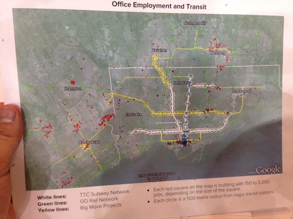
[The image above was posted on Twitter by Rishi L (@CdnEnginerd).  Click for full size version.]

The purpose of this map is to show how office employment is not sited along existing or proposed rapid transit lines.  With this as a jumping off point, the Panel suggests there is a need for a “Big U”, a much enhanced GO Transit route from Meadowvale, through Union Station and then north via the Uxbridge Subdivision (Stouffville line) to Markham.

A related factoid (one of those handy bits of information whose presence is supposed to silence critics) is that employment concentrations generate far more transit usage than residential ones.  It is certainly true that it is much easier to serve a place like downtown Toronto with a transit network that acts like a big funnel, but this does not eliminate the need to serve the residential ends of those trips.

Toronto’s Bloor-Danforth subway and GO’s commuter lines, for example, spend much of their time running through comparatively low-density neighbourhoods, collecting passengers as walk-ins, park-and-rides, and transfers from the surface transit network.  Every time a new transit route is proposed, we hear how it will only be viable if stations are surrounded by huge condo developments.  This is utter nonsense because any transit route has a catchment area.  The problem is to ensure that transit, sidewalks and bike lanes serve that area and deliver riders to a network that will take them where they want to go.

What is missing from the chart above is any indication of where the people who work in those centres actually live.  Looking at the Meadowvale end of the line, how many people come from the area that would be served by the GO corridor and a feeder network to it?  There is a lot of territory north, west and south of Meadowvale for which a rapid transit line to the east will do absolutely nothing.  Similarly, many who work in Markham live west, north and east of the employment centres.  Indeed, most of the red dots on that map are well west of the rail corridor.

Much as I sympathize with the Panel’s desire to get people talking about how parts of any network proposal might actually serve the region, I fear that we are seeing a classic example of someone who got out their crayons and drew a map.  The job will quickly change from discussing the philosophy of transit planning (and, don’t forget, funding) to defending the specifics of a proposal.

That is precisely why I have been so restrained about getting out my own crayons except in special circumstances.  The recent Don Mills Subway discussion needed a line on a map to illustrate how the “downtown” focus needed to change.  Well over half of the debate this triggered became a matter of dueling proposals between “my” line and “your” line that added little to the real issue — the need to see what such a line could connect and serve beyond simply diverting trips away from Bloor-Yonge Station.

People would even argue that there wasn’t “enough” development in some locations to justify such a route ignoring what is there today, what is in the pipeline for tomorrow and what could occur with planning and political encouragement.  Meanwhile, we build a subway to land that was recently the middle of nowhere, and propose one through miles of low density residential development as a vote-buyer claiming that only with a subway will Scarborough reap the development it “deserves”.

There is one big problem with the “Big U” — it diverts attention from the “little u” otherwise known as the “Downtown Relief Line”.  It doesn’t help one bit that the version of the “little u” shown on the map is the Pape-Queen-Roncesvalles alignment, one that is guaranteed to be very expensive and fails to recognize shifting development patterns (ironically, one of the goals of the “Big U”).  It ignores the southerly shift of population and jobs, avoids the available Weston rail corridor where we are spending a fortune to intensify transit infrastructure for a Toonerville Trolley to the airport, and it stops at the Bloor-Danforth subway missing the opportunity to reach further north to be more than a “downtown” line.

“Alternatives analysis” is a fine art in many projects, but the real art for many agencies is to ensure that what you always wanted to build is the “preferred” choice.  This is often guaranteed by setting up straw man comparisons so that the one you want shines out as the best of breed.  Such may be the situation with the DRL where, on darker days, I suspect that the whole idea is to paint as grim a picture as possible so that it will never be built.  Remember that the TTC for decades claimed we didn’t need a DRL, that they could stuff everyone into an upgraded Yonge-University line.  Expanding YUS capacity on a heroic scale was their “preferred alternative”.

With the Big and little U’s, we risk being trapped into specifics of route designs that looked good on a napkin in a bar, but which need much more thorough discussion as to purpose and specifics.  They are good as starting points for discussion, but are most definitely not the final answer in their respective fields.  Moreover, they are not alternatives to each other, a point that is often lost as the political imperative says “build in the suburbs, not downtown”.

The Big Move and the Investment Strategy that supports it have one gaping hole.  Very little attention is paid to the role of or funding for the feeder network to a regional system.  Moreover, the plethora of lines on the map hides the fact that many of them will not have the most frequent service on the planet.  Not all “rapid transit” lines are created equal.  As a recent Metrolinx report noted, the growth in “rapid transit” recently has mainly been in “BRT Light” for which the infrastructure requirements are minimal along with the service levels.  Crowing about progress in bringing transit to the millions ignores the question of how attractive that transit will be and how people will connect from the trunk routes, such as they may be, to their homes, work and other destinations.

This will be an important issue for network design on both the Big and little U’s.  One would serve rail corridors and be totally dependent on local service to deliver riders from homes and to employment locations.  The other would serve established and growing neighbourhoods and would enjoy an existing, well-developed set of local transit services as feeders.  These are not trivial differences, but they show the problems that will arise if the study does not look beyond the edges of station platforms.

This is the real debate the Transit Panel should engage — does The Big Move really serve the market it claims to address?  How useful will it be in attracting trips out of cars and onto transit?  Can developers and owners of residential and employment properties expect a real improvement in travel to and from their developments, or will their value be strangled by poor access?  Underlying all this is the basic question of whether we are spending all of those billions in the “right” place and what benefit each component of the proposed network will achieve.  That speaks directly to the concept of spending wisely, not just for the sake of generating construction jobs and photo ops for the next generation of politicians.

Returning to the “little u”, there will be a motion before Council from Councillor Josh Matlow, seconded by Cllr. John Parker (also a member of the TTC Board), to accelerate work on the EA for a “Relief Subway Line”.  Moreover, it asks that Council confirm such a route as “Toronto’s next subway expansion priority”.  It will be intriguing to see how this motion fares amid the current circus at City Hall, the recent battle over the Scarborough Subway and a faction claiming that downtown “has enough subways” already.

If this proceeds, it will be vital that it not be hamstrung with narrow terms of reference that filter out options before they are even discussed.  A major shortcoming of the new “Transit Project Assessment” protocol is that there is no consideration of alternatives because the decision that something is a “good project” is already assumed.  Debating alternatives just gums up the works in what is supposed to be an expedited process, but actually winds up as an exercise in selling an already-determined choice.  This is precisely the criticism many had of Transit City that compounded the process with less than stellar detailed planning and “sales”.  (Moreover, once a project is approved, it can be amended beyond all recognition, even though the original design was the one that “justified” the project in the first place.)

There is no point in doing a study if the underlying desire at the political and staff level is to sell a “Big U” as a replacement for the “Relief” line, whatever we call it.  The terms of reference must ensure that all options are reviewed, including cross-jurisdictional issues such as repurposing the Weston corridor’s UPX trackage for rapid transit.  We must not prejudge the outcome by requiring one continuous line to serve both legs of the U/u, especially considering that in some variants both western legs run in the same corridor.

Will Toronto Council, Metrolinx and Queen’s Park embrace the need for a full study of these routes without prejudice toward any preconceived doodlings on maps?

Measuring The Big Move

At it’s September Board meeting, Metrolinx received a report on a strategy for tracking the benefits of their regional plan, The Big Move.  At the time, this and other business was overtaken by their slavish support for Transportation Minister Murray’s alternative to the Scarborough Subway.  Now that the panel reviewing the Transit Investment Strategy has begun its public meetings and will soon report with recommendations on how we will all pay for The Big Move, a look at the measurement tools is in order.

Regular readers here will know that I deeply distrust “Key Performance Indicators” from my own days in public sector management.  They can be an exercise in so compressing information to a single-dimensional value that meaningful oversight is impossible.  Even worse, they may be constructed to validate what management is already doing in an uncritical way.  I have approached the new Big Move KPIs with the same skeptical outlook.

The Baseline Monitoring Report and its appendices are linked from the main Big Move page on the Metrolinx site (not to be confused with the Big Move’s own website).  By looking at the proposed KPIs, we can learn what Metrolinx considers to be a mark of “success” and, conversely, what they don’t bother to measure.

The Full Report gives an overview of the scheme and how it was developed, but the details of the KPIs are found in Appendix A: Monitoring Handbook.

The report notes that circumstances have changed since The Big Move was first published with shifting demographics, population growth, and economic effects that alter how people make choices (if options are available) about travel.  This provides a context for the current set of KPIs, although there is no discussion of how sensitive these might be to major shifts in the economic and transportation context.

The table below shows the questions Metrolinx seeks to answer and, broadly, the types of measurements they would use.  [Page 7]

BaselineKPIOverview

Having set out to define metrics, the Full Report then turns to the more general area of “progress” and poses these questions:

The Big Move sets out ten strategies with 92 Priority Actions and Supporting Policies to achieve its vision, goals, and objectives. Are we making progress towards each of the Priority Actions? Are we implementing the Supporting Policies? [Page 10]

What follows are many pages listing all of the projects in various stages of planning, execution and completion throughout the GTHA.  What is absent, however, is any quantification of the contribution each of these has made to achieving the overall goals (or will contribute when long-promised projects actually start providing service rather than photo-ops).  While all this has been going on, the progress, as measured by some of the KPIs, of actually improving transportation has been less than stellar.

A major challenge to any planner, operator or politician is that our environment is not static.  Every year, the regional population grows by about 100K, and much of that growth occurs in areas poorly served by transit.  Moreover, the travel demands from this growing population are many-to-many and do not lie conveniently along a handful of corridors where a few strategic upgrades could solve all of our problems.

If the population were static, we could talk about new lines providing real benefits.  However, when the population grows by 1-million in the decade needed to deliver major transit projects, any benefits are swamped in the losses to inaction in those parts of the region where no transit upgrades worth mentioning have occurred.

The past decade’s history is a classic cycle — a boom leading to grand announcements (including The Big Move itself), a bust in which the dreams are shattered and most plans go into limbo, and a tentative recovery where announcements of a bright future collide with “we’ve heard it all before”.  What did not stop was the population growth, and our collective timidity to invest in better transit has left the region ever more dependent, overall, on auto-based transportation.  This is not the work of evil, car-loving maniacs bent on environmental destruction; it is the simple choice of millions of people for whom the car is the only viable option.

Continue reading

The Transit Investment Panel: The Transit We Need

The provincial Transit Investment Panel has published the second of three discussion papers in advance of public meetings slated to start next week.  The paper is entitled “The Transit We Need” and it addresses filtering criteria by which possible transit projects should be judged.

This paper is odd on a few counts.  First off, it covers similar territory to the first “Hard Truths” paper by talking about meaningful criteria for inclusion of projects in competition for funding.  Second, it does not include specific proposals for alternatives to The Big Move, even though such a proposal was mooted by the panel’s Vice Chair Paul Bedford at a recent public presentation at UofT and obliquely mentioned in a Globe and Mail commentary (only available online).

The idea of a regional relief line that would connect several of the existing and proposed Metrolinx projects in a single line linking municipalities from Mississauga to Markham via downtown Toronto is worthy of exploration. Indeed, Metrolinx is in the midst of studying regional relief strategies right now. This would not constitute a re-mapping of the Big Move, but rather a strategic modification to better accommodate current and anticipated growth.

There is a fascination recently with advocacy for anything that might remove the need to build the Downtown Relief Line (or Don Mills Subway, or whatever we might call it), and the “Big U”, as Bedford calls it, is politically attractive because it goes out into the 905.  There is even a possibility at some distant future date that counter-peak flow to job centres in the 905 would add to the value of such a line provided that there is any local transit service to act as a distributor.

This does not eliminate the need for more local capacity into the core area especially if fare structures leave 905 residents clamouring for a subway to give them a cheap, frequent ride into downtown and riders from the 416 be damned.

The panel proposes a number of filters by which new lines would be evaluated, but gives no indication of the relative priority of these filters, or any relationship between the capital (and future operating) cost of a line versus the effect it might have (or not have) under these criteria.  This is rather like someone saying that we will cut taxes through “elimination of waste” without bothering to define the term or explaining how to find it.

Continue reading

A Don Mills Subway For Toronto

This is a companion article to one of the same name on the Torontoist website in which I argue that Toronto should have a subway line from Front & Spadina to Eglinton & Don Mills.  Formerly known as the “Downtown Relief Line”, this should be called the “Don Mills Subway” and there should be no pretensions about it stopping at Danforth.

Drawing subway lines on maps, especially for the DRL, has been a cottage industry among transit advocates and city watchers for several years, and everyone has their preferences.  I have stayed away from that territory most of the time because the torrent of comments (including a long thread on this side) is more than I care to moderate.

However, the Don Mills line needs advocacy and a good indication of what it might look like to counter the “downtown has enough subways” drivel dished out by Mayor Ford.

My proposed alignment is not intended to be definitive although parts of it are locked down to make specific connections and to take into account physical constraints on the route’s placement.  Other alignments are possible in places, but I don’t want to revisit that discussion in excruciating detail when the basic purpose is to show what a new line could achieve.
Continue reading

Updating TTC Wayfinding

This article has been split apart from the coverage of the October TTC Board meeting to accommodate updates and to keep the comment thread separate from other issues.

The Board considered a presentation entitled New Wayfinding Standards which, among other things, proposed a change in naming for subway lines to the use of numerals.  This has provoked no end of comment, some on this blog, as an ill-advised waste of money.

More to the point, this presentation is neither a “standard” nor a comprehensive review of TTC wayfinding.  It is an overview of a few changes, and even these are not set out on a thorough basis.  What we have here is a proposed trial, but not a systemic review of wayfinding.

The goals are simple: avoid multiple styles of signs, convey information in a consistent way so that riders know the “language” of the signs across the system, make maps easier to understand, and make all forms of wayfinding more accessible.  One style, one letter font, one style of branding should identify a “TTC” message wherever it appears.

Consistency and legibility are not important just for the casual user, but for the regular passenger who  may be in an unfamiliar part of the system.  They may walk through their “home” station on auto-pilot, but off of their regular territory, they too will be “tourists”.

Continue reading