The TTC Board met on February 24, 2025 with an agenda that seemed light going in, but the meeting itself ran well into the afternoon partly due to a long in camera discussion and partly to debates that expanded the scope of the items on the agenda.
Notable by its absence was a report on establishment of a Strategic Planning Committee, an item approved by the Board on January 10 with an implementation plan due at the February 24 meeting. (See minutes at p. 3) Such a committee is vital so that consultation and planning can occur before and while the 2026 budget is in preparation, a process that gets underway in roughly June-July each year. If there is to be some brave new vision of what transit can become, there is no point in asking that it be included in an already final budget in December.
Revised at 6:30 pm on February 23, 2025: Additional RSZ charts posted to the Urban Toronto site over the past year were passed on to me by a reader. I have incorporated info from them into the charts below to fill in several blanks in my own data.
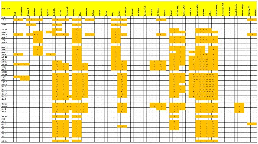
For roughly one year, the TTC has published a list of reduced speed zones (RSZ) on the subway system. Many of these are long-lasting and span multiple stations.
In recent discussions of service quality, TTC management speaks of twelve zones as a reasonable number to exist at any time. Things will go out of whack, or otherwise need repair, to be sure, but the number and longevity of RSZs is extremely frustrating for riders.
As with some other performance indices, the one chosen by the TTC only tells part of the story, even if we agree (which I do not) that having 12 RSZs is perfectly acceptable. What this number does not tell is the extent of each slow order (mileage or proportion of the line affected) or duration (days, weeks, months). Indeed, TTC could get the number down to two simply by making all of Lines 1 and 2 an RSZ. That is obviously nonsense, but shows the problem inherent in just counting items in a list.
The charts below show the areas with RSZs for the two major subway lines over the past year. I was not assiduously collecting this information every week, and used the Internet Archive to fill in a few gaps. Where there is a break of more than a week in my snapshots, I have left a blank line in the chart, although the similarity of data before and after the break suggests that the RSZs persisted.
Most striking about these charts is the proportion of Line 1 that has been under an RSZ for the past year. Some problem areas appear and disappear implying that the problem was minor and fixed quickly, but others are permanent.
A common factor among many of the affected areas is that they are in open areas where track sits on ties and ballast. These are subject to shifting and deterioration far more so than track in tunnels that is bolted to the concrete floor, or sitting on concrete ties (except for switches and crossings). This makes repairs more complex compounded by the problems of working in winter. However, these areas have been on the chart since long before the snow, and a real problem for the TTC is whether repairs can even be achieved in weekend shutdowns.
There are many problems with how the TTC reports is own performance, notably that problems are understated or masked by the choice of metric and presentation. A further concern from these charts is whether the TTC will ever dig itself out of the backlog of work they represent.
Reading the charts:
The colour bands extend from the limits of a slow order as shown on TTC maps or text descriptions.
The symbols “>” and “<” indicate the affected direction of travel, and “<>” means “both ways”.
I will update these charts from time to time to show the TTC’s progress, or not, in resolution of chronic subway slow zone problems.
From May until early Fall, the TTC and City of Toronto will rebuild an aging water main and track at the intersection of King & Church Streets. A report before Toronto & East York Community Council on February 20, 2025, details plans for service diversions and transit priority measures.
There are two general plans for this project: the first is for phases when the intersection remains open for east-west traffic, and the second for the period when it will be closed. Note that the planned diversions are not the same as in the recent Annual Service Plan. Significant changes are the provision of service to the Distillery District replacing the 504A streetcar with the 504C bus, and the extension of 503 Kingston Road west to Dufferin Loop as opposed to the originally planned McCaul Loop.
Service along Queen Street between River and Spadina will substantially increase with the routes normally on King diverted to the north. Buses will operate as a streetcar replacement.
Traffic restrictions such as parking and turning permissions will change to provide more capacity for transit. Although the report cites the use of traffic wardens and changes to signal timings, it is silent on provisions for the much increased volume of streetcar turns at intersections where no priority signals exist today. (I await feedback from the City on exactly what they propose.)
The entire stretch of Queen Street as well as the Richmond/Adelaide diversion will not be used for CaféTO installations to conserve road space.
As part of this plan, a reserved lane will be created for streetcars eastbound approaching Broadview on Queen, and left turns by other traffic will be banned there.
Restrictions will be in effect from May 11 to October 14, 2025, although the City project is planned to run until August. Streetcar service could return in September, but this will depend on TTC plans for overhead reconstruction on King Street East and on the Sumach/Cherry branch to the Distillery District.
Details of routes and planned changes to traffic regulations follow in the full version of this article.
Updated Feb 18, 2025 at 12:55pm:A TTC report with more extensive information about the proposal was posted today as part of the Board’s agenda for February 24. Information from that report has been merged into this article.
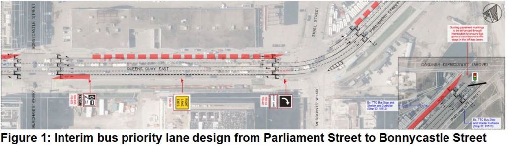
In the long wait for any kind of transit improvement for the eastern waterfront, the City of Toronto and TTC now plan to install reserved bus lanes on Queens Quay between Bay and Parliament Streets. A short stretch is also proposed for Front Street between Bay and Yonge Streets eastbound.
The proposal would add red lanes:
eastbound on Queens Quay from Jarvis to Parliament,
westbound on Queens Quay from Parliament to Bay, and
eastbound on Front from Bay to Yonge.
The Martin Goodman Trail (cycling) will not be affected. A new westbound right turn lane will be added on Queens Quay at Jarvis. Parking spaces will be removed on Front east of Bay Street.
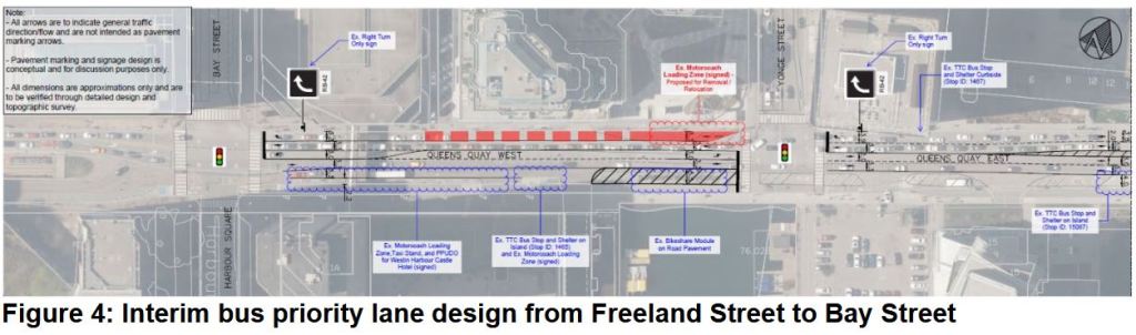
Updated Feb. 18, 2025: Maps of the proposed changes to Queens Quay and to Front Street are included in the TTC report.
There is more reservation westbound on Queens Quay than eastbound, and that is the direction with the worst congestion problems. The south side offers less space for creation of a bus lane, and in some cases there might be lane narrowing to free up space for the north side.
The reserved lane westbound is generally in the curb lane, but between Sherbourne and Jarvis it will be the second from the curb. The curb lane will be dedicated to right turns given the high demand for this at Jarvis. With this change, the westbound stop at Richardson Street will be removed. The lane disappears between Cooper and Yonge Streets due to space constraints, but reappears west of Yonge in an area now used for Motorcoach loading.
On Front Street, although this is a “red lane”, the intent is for storage of up to five buses, not for speedy travel. Moreover, the bus stop will be shifted further east adding to the walking distance for riders to Union Station.
The accessible loading zone will shift west behind the bus layby. The layby area is now occupied by ten parking spaces which will be removed. This area will be shared by 114 Queens Quay, 19 Bay and 202 Cherry Beach.
For further details on the proposal, please see the TTC Report at pp 12-15.
[End of Feb. 18 update]
The area is now served, albeit infrequently, by a mix of routes that can often be snarled in traffic. The intent is to save up to five minutes travel time between Bay and Parliament. The reserved lanes will also host future improved service to developments on the eastern waterfront pending construction of the planned, but long-delayed Waterfront East LRT.
In May 2024, 114 Queens Quay replaced the southern end of 19 Bay which now terminates at Front Street. From a loop via Front, Yonge, Wellington and Bay it runs south on Bay then east on Queens Quay into the Port Lands. The 114 operates every 10 minutes in peak periods, 12-15 minutes at other times. This is the primary route serving waterfront developments.
202 Cherry Beach (summer months only) runs from the same downtown loop as the 119 and follows its route as far as Parliament where it shifts north to serve the Distillery District. The 202 then turns south via Cherry Street to a loop at Cherry Beach. In summer 2024, this route operated every 20-30 minutes with no service in the AM peak.
75 Sherbourne has a south end loop via Sherbourne, Queens Quay, Jarvis and The Esplanade. It operates every 6-8 minutes during weekday daytime, and 20 minutes or more during most other periods.
65 Parliament loops at the George Brown Campus on Queens Quay. (This loop was the former eastern terminus of 19 Bay). It operates every 8-9 minutes during peak periods, 13-15 minutes at other times. Overnight service is provided every half hour by 365 Parliament.
The service between Union Station and the waterfront on 114 Queens Quay is not on a par with other routes that have dedicated lanes, and real improvement in accessibility of the waterfront will only come with much better service and eventually the LRT link via the Bay Street tunnel. A recommendation and decision on staging of the LRT should come to Council and the TTC later in 2025, but the project is not funded.
Public consultation will be held via a survey that is active until Thursday, February 20, and via three sessions:
Tuesday, February 18, 2025, 7:00 – 8:30 p.m. This session was held via webex.
Wednesday, February 19, 2025 at the George Brown Waterfront Campus:
3 – 5 p.m. A pop-up event will occur in the main lobby.
7:00 – 8:30 p.m. An in person session in the 2nd floor main auditorium, room 237.
This page will be updated when more information is available.
The TTC has added a section for streetcars to its list of speed zone restrictions. As of February 17, TTC claims that there are only five of them.
Location
Affected Routes (per TTC)
Dundas St. at the DVP Bridge
505
Bathurst St. at Bridgeman Ave. (*)
511
King & Church Intersection
503/303, 504/304
Queen St. E. & Degrassi St. (*)
501/301
Queens Quay from York to the Harbourfront Tunnel (*)
509
(*) Seasonal restriction during winter.
This table is inaccurate on so many counts it is embarrassing.
Bridgman (the correct spelling) actually refers to the underpass north of Dupont Street at the CPR. This is non-revenue trackage used primarily by 512 St. Clair cars entering and leaving service. The 511 Bathurst car does not run this far north.
King & Church also hosts the 508 Lake Shore car and 501 Queen cars when they cannot divert via Richmond/Adelaide.
Queen & De Grassi (the correct spelling) is near an overpass on the GO Lake Shore East corridor. The 503/303 services also operate here, not to mention carhouse trips to Leslie Barns for other routes.
Queens Quay is also used by 510/310 Spadina when the route operates with streetcars.
After repair work on Dundas Street, the slow order was lifted but has mysteriously returned.
Updated Feb. 17/25 at 6:20pm: I have been advised by a reader that the Dundas slow order is due to noise complaints from a neighbouring resident, not due to track conditions, and that the complaint came via the local Councillor. Streetcars have operated here for over a century. If there is are issues with rough track or broken joints causing new noise, then fix them.
This may seem as if I’m quibbling, but there is a much longer list of permanent speed restrictions in effect:
All facing point switches have a mandatory stop to check their setting.
All special work (switches, crossings) are operated at low speed until the rear of the car clears the junction.
All underpasses are operated at low speed. This is a holdover from trolley pole operation lest a dewirement damage the car and/or overhead.
In theory, streetcars are not supposed to pass at junctions lest one of them derail and strike the other. In practice only junior operators following all of the rules observe this.
Where reserved lanes cross roads such as on The Queensway, streetcars are to operate at low speed lest an auto make a left turn in front of them.
These practices have accumulated over time in the name of safety, a TTC watchword that in at least some cases is a cover for lack of maintenance.
Problems with misbehaving electric switches go back three decades to controllers installed to deal with streetcars of different lengths (CLRVs and ALRVs). These were always problematic, and the TTC is only now working through their replacement. That capital project has been on the books for years.
The track at Church & King is long overdue for replacement and this is finally scheduled for 2025. There have been enough intersections with problematic trackwork that a blanket slow order is easier to implement than an ever-changing site-specific list. This affects streetcar service everywhere because the TTC network has so many crossings.
Some errors in the TTC’s list are trivial, but they show that whoever built it does not know the system. The obvious concern is the accuracy of other defect lists for TTC infrastructure and vehicles. The SRT derailment and various subway incidents revealed issues with rapid transit inspection and maintenance. Why can the TTC not accurately report the condition of their own system? They have a substantial “Enterprise Asset Management System”, but this is only as good as the information fed to it.
The City and TTC seek a new CEO for our transit system. One early job for the “lucky” candidate will be to look under a lot of rocks to see just what the state of the system is, and how much has been missed or hidden from sight.
This is a long article with increasing levels of detail toward the end. Feel free to bail out, or come back later.
Although problems with severe congestion delaying transit downtown were somewhat reduced by the addition of Traffic Wardens by the City of Toronto in 2024, reliability issues continue to affect service along the King route. The situation illustrates a few of the service design and management challenges for this type of route, and shows how simply reducing congestion will not necessarily provide regular service.
504 King is unusual in having four terminals: Dundas West Station and Dufferin Loop in the west, Broadview Station and Distillery Loop in the east. The TTC only measures service reliability at terminals, but the overlapping 504A and 504B services must blend together to provide the advertised quality.
The 504 shares with other streetcar routes a much wider headway than existed before the pandemic. This is due primarily to the change in vehicle size, and only partly to riding levels. With less frequent service, regular spacing is more important because scheduled gaps between vehicles are already wide, and can get much wider. This is compounded by overlapping services on the 504A (Distillery to Dundas West) and 504B (Broadview to Dufferin). Nothing in the service design or line management ensures that these blend evenly, and the design provides very frequent service only on paper.
The table below compares headways on routes that operated with the shorter CLRV streetcars in January 2019 versus the new Flexitys in January 2025.
Route and Period
January 2019
January 2025
501 Queen to Humber
AM Peak
4’15”
10’00”
Midday
4’45”
9’00”
PM Peak
4’50”
8’30”
Early Evening
4’30”
10’00”
506 Carlton
AM Peak
5’10”
10’00”
Midday
5’20”
10’00”
PM Peak
5’40”
10’00”
Early Evening
7’10”
10’00”
The next table compares headways on routes that were already running Flexitys in 2019. (The Distillery District was originally served by 514 Cherry which ran from Distillery Loop to Dufferin Loop. In October 2018, the service design changed to the 504A/B configuration we have today.) 504 King service is less frequent than in 2019, and even less frequent than in November 2017 when the transit mall was implemented and the line was running with the smaller CLRVs.
512 St. Clair saw a substantial drop in service in May 2023 when headways increased from roughly 6 to 8 minutes. Not long after, the route then went through a long, painful period of bus operation during multiple, overlapping TTC and City projects. TTC plans to restore 6 minute or better service in late 2025. (Yes, you are reading that table correctly: peak service now is about half what it was in 2019.
Route and Period
January 2019
January 2025
504 King
AM Peak
5’15” on each branch
8’00” on each branch
Midday
7’00” on each branch
10’00” on each branch
PM Peak
6’00” on each branch
10’00” on each branch
Early Evening
6’30” on each branch
10’00” on each branch
512 St. Clair
AM Peak
3’45”
8’00”
Midday
4’45”
8’00”
PM Peak
4’10”
8’00”
Early Evening
6’45”
8’00”
Other routes were operating with buses in 2019 or 2025, and they are omitted here although their streetcar service is also less frequent now than it once was.
Although the service capacity in the case of 501 Queen and 506 Carlton is roughly the same allowing for the difference in vehicle size, the situation on 504 King and 512 St. Clair shows a marked reduction of capacity. This is an example of how the TTC is most definitely not back to 100% of pre-covid service, no matter how many media events make that claim.
With a wider scheduled headway, gaps will be wider too if either a vehicle is missing (e.g. a short turn) or vehicles are bunched together. When the scheduled service was frequent, some bunching was inevitable because vehicles were already close together. A management style that worked tolerably for frequent service does not work when fewer, more widely-spaced cars serve a route.
In this article, I will review performance of the 504 King route in January 2025, and show comparative data from earlier periods.
Updated February 7, 2025 at 8:00pm: It occurred to me that although charts here are produced with maximum Y-values of an hour, or even 90 minutes, that this shows the peak times while compressing the visual range of the area where averages change over time. I have added a second set of charts for 2016-2025 with the maximum Y of 30 minutes to give the area where averages move between 15 and 25 minutes more “elbow room” and to make the evolution of values easier for readers to see. These have been added at the end of the “Implementing the Transit Mall” section.
In previous articles, I have posted charts showing the changes in travel times on the central portion of the 504 King route between Jarvis to Bathurst. This is the area covered by the supposed transit mall, although the degree to which streetcars actually have priority has varied over time for various reasons.
This article will review how travel times have evolved in recent years, as well as looking back to pre-pandemic and pre-transit mall eras. Full chart sets are available via links to PDFs for those who are interested.
Beyond that central section lies the conventional “streetcar” portion of the route west through Bathurst/Niagara, Liberty Village and Parkdale. To the east is the northern reaches of the St. Lawrence and Distillery districts. Do these deserve the same level of priority treatment? What would be the benefit if any? I will turn to those areas later in the article.
For those familiar with similar analyses on this site, I have retained the format of charting the 50th percentile (median) and 85th percentile values. These show both the general trend over time as well as the degree by which trips can vary from the median affecting reliability both in the priority area and on the broader route.
Significant events include the implementation of transit priority in November 2016, the covid lockdown in March 2020, and the effect of enforcement (or lack of it) on the ability of streetcars to move briskly through the priority area. Also important to note is that the effects differ by time and direction, and that congestion interferes with transit not just during the classic peak periods.
The important history lesson on King Street is that transit priority can improve travel times, but more importantly can improve reliability leading to more predictable trips and vehicle spacing over a route even beyond the bounds of the priority scheme’s area. Moreover, the benefits are easily lost through lack of enforcement and external events that significantly change demand on the road network.
There are relatively few service changes for the mid-February schedules, and most are on the bus network. There is no change in subway service.
The major change for construction is the start of work at the Bathurst, Fleet, Lake Shore intersection for water main replacement and track renewal. This will be ongoing in stages until June 2025. 511 Bathurst and 509 Harbourfront cars will be replaced by buses at the south and west ends of each line respectively.
With the completion of construction at Jane Station, the temporary route shifts to Old Mill and Runnymede Stations are reversed and service returns to Jane Station. This change is actually already in place 26 Dupont, 35/935/335 Jane, and 55 Warren Park. The schedules are now catching up. The 71/77 Runnymede/Swansea interline will be broken and the individual routes will loop in Runnymede Station.
Bus bay allocations at Warden and Victoria Park Stations will change to better suit the routes operating there.
Destination signs on many routes will be modified to standardize references to stations such as Scarborough Town Centre, Coxwell, Greenwood and Wilson Stations.
Service on the 300 Bloor-Danforth and 320 Yonge night buses will be improved to deal with scheduling and crowding problems. I have an article in preparation on this situation using December 2024 and January 2025 tracking data as a “before” view of service quality which is extremely poor.