
Work on the Waterfront East LRT crept forward with the approval by Toronto’s Executive Committee of funding to continue design work, and of a tentative project plan. This must be endorsed by Council at its meeting of November 8-10, 2023.
For the previous update on this project, please see my April 2023 article.
Updated: Shortly after this article was published, the City of Toronto replied to questions I had posed about their report. The replies are integrated with the text of the article.
A combination of several factors push the completion date of this project, assuming that it receives full funding from provincial and/or federal sources, out into the 2030s. There is a danger that a so-called transit first community will actually see much of its redevelopment occur before adequate transit is in place to support it. Conversely, absent the transit service, some planned projects may simply sit as empty lots because they are not viable without it.
The current round of reports includes:
- Advancing Waterfront East Light Rail Transit (the main report)
- Preliminary Design Business Case
- Constructability Assessment Summary
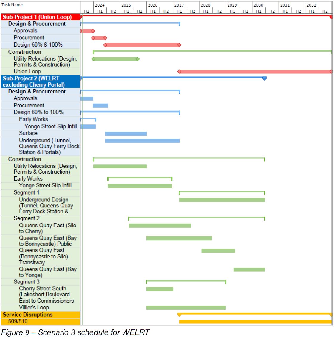
The WELRT has been divided into three segments.
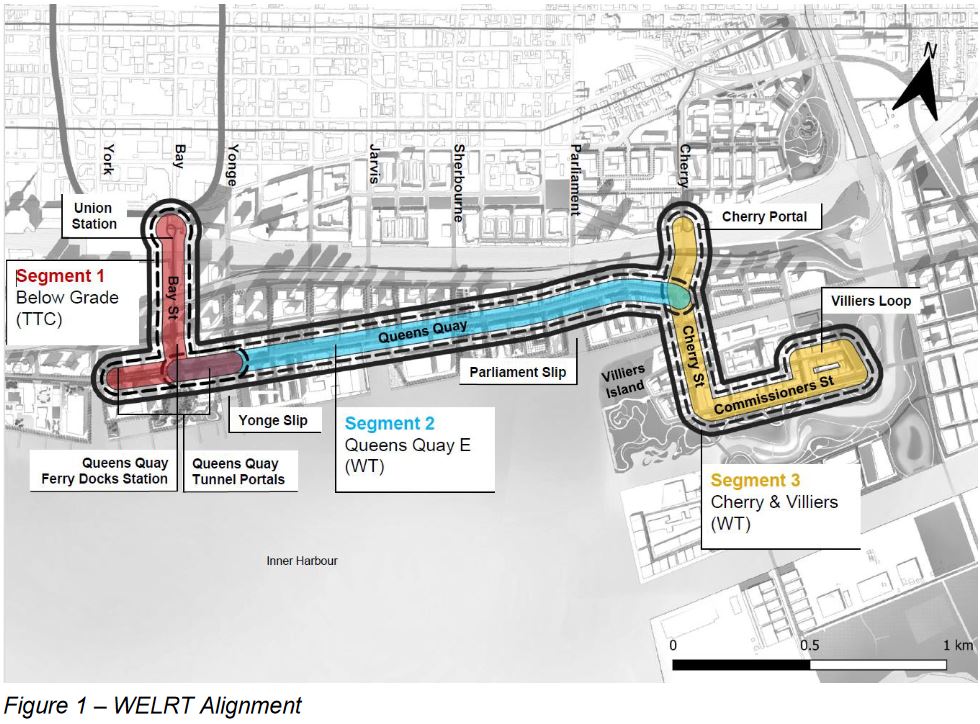
- Segment 1 (red) contains the Bay Street tunnel and the portals at Queens Quay where streetcars will surface. The existing west portal will be renovated and the new east portal added. Plans for decorative canopies have been dropped from the plan as a cost saving measure. This segment is under the TTC’s control for design and construction.
- Segment 2 (blue) consists of the surface running on Queens Quay East to a revised intersection at Cherry Street which is realigned to the west. This segment primarily involved the reconfiguration of Queens Quay East similar to what already exists on Queens Quay West. (For details please refer to previous articles.)
- Segment 3 (yellow) includes the southerly extension of trackage from Distillery Loop under the GO corridor, along a realigned Cherry Street, and east on Commissioners St to Villiers Loop (which is actually an around-the-block terminus, not an off street loop).
There are impediments to the work on segments 1 and 3 that dictate the timing of various works. The many delays in actually launching the WELRT project put other works in the same area in conflict that might otherwise be avoided notably the Ontario Line and the Gardiner/DVP realignment. The Bay Street tunnel has become more complex due to updated fire codes and the need to serve many more passengers than the Union Station Loop does today. Still outstanding is the redesign and expansion of Queens Quay Station and a link to the Island Ferry Docks which has been dropped from the project, as of the last update in April 2023.
The recommendations approved by Executive Committee are that:
- Council approve the alignment shown in the report.
- Council approve advancing design for the entire project, except segment 1 (underground), to 60%.
- Council approve
- completion of environmental approvals,
- undertaking of a traffic management plan to address interfacing the WELRT an other projects’ construction, and
- design and coordination of the scope for the WELRT at the Cherry Lake Shore realignment, the Inner Harbour Tunnel at Jarvis, and the Hydro One relocation project at Cherry Portal.
- Council authorize an increase to the Transit Expansion Division’s Capital plan of $63.6 million in 2024-2026.
- Council direct the Executive Director of the Transit Expansion Division to report back at some point, unspecified, in 2024 with an update.
The estimated cost of the full project is $2.57 billion over a ten-year period assuming that full funding comes in Q1 2024, and the design work proposed in this report starts immediately. Any delay is a notable concern in an era when construction material and labour costs are rising quickly. It is not clear whether the figure cited is in current 2023 dollars, or includes inflation to the point the money is actually spent. I await clarification on this from the City.
Updated: The City of Toronto advises that:
The City is using as-spent dollars with future escalation included to the anticipated year of the expenditure. The cost estimate relies upon timely funding to meet the implementation schedule which is used as the basis for these inflation numbers.
Email from City of Toronto Media Relations, Nov. 2/23
The reason that the underground segment is excluded from approved design in recommendation 2 above is that this segment is proposed to be executed with a design-build contract where the detailed design will be undertaken by a contractor who is familiar with work in an underground environment.
Updated: This also keeps the design cost off of the City’s expenses for the moment. The City of Toronto advises that:
As noted in the staff report, staff are not recommending advancing the design of Segment 1 to 60% due to the City’s current financial pressures.
Email from City of Toronto Media Relations, Nov. 2/23
The project is subdivided into three parts:
- Union Station Loop, $932 million.
- Remainder of project except Cherry North, $1.3 billion. Includes East and West portals on Queens Quay, Queens Quay Station, Yonge Slip infill, Queens Quay East track from Bay to Cherry, Cherry Street south, Commissioners Street and Villiers Loop.
- Cherry North connection to Distillery District, $337 million, to be completed as a separate future phase.
The scope of work planned at Queens Quay Station is unclear because at the last update, much of this work had been dropped (platform expansion, link to adjacent building, link to ferry docks). I have asked the City for clarification of this.
Updated: The City of Toronto advises that:
The current scope for Queens Quay Ferry Docks Station is related to the station access upgrades (upgrade of the west entrance to improve accessibility) and it is part of the Segment 1 scope.
Email from City of Toronto Media Relations, Nov. 2/23
For the benefit of latecomers to the Waterfront East project, I have included a history at the end of the article. The idea goes back at least to the 2003 Central Waterfront Plan, and has languished without strong political support ever since the Ford era when all focus shifted to subways.
The greatest challenge was and remains that waterfront transit is not “important enough” to many on Council and lacked key leadership from the Mayor’s office through the John Tory era. Under Mayor Chow, it will compete with many other projects for priority and funding both for transit and in the wider context of City projects.
Three decades after the Central Waterfront Plan and a 2011 target opening date, we might still not have good service to our “transit first” neighbourhood by 2032.
Constructability
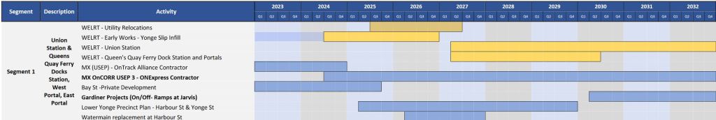
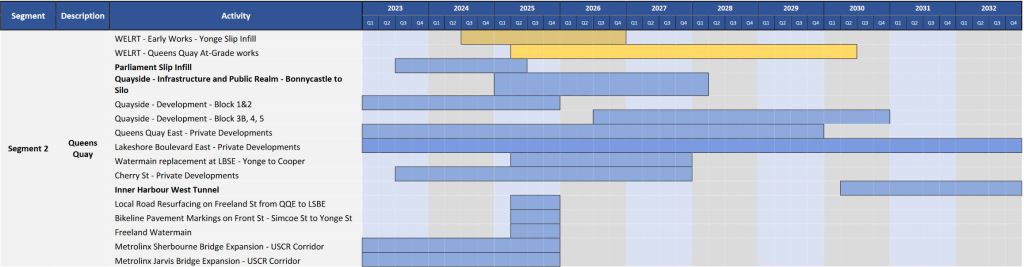
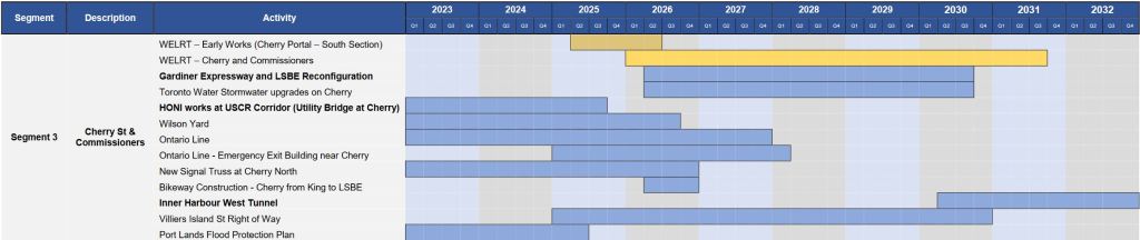
The heart of the report lies in the Constructability Assessment.
There are many competing projects that will affect the timing of work on the line and, therefore, the suitability of various staging schemes. The timing of these projects is shown below. (Click to open in a gallery.)
- For the proposed new Queens Quay East, the existing slips at Yonge and at Parliament will be partly filled. At Yonge, this will provide an eastern access to the Harbour Castle hotel. At Parliament, this will allow the extension of Queens Quay straight east to Cherry rather than curving north to Lake Shore as it does now.
- The Inner Harbour West Tunnel is part of a large project to intercept storm water flows and keep sewage out of the Harbour.
- Various Metrolinx projects are in support of GO expansion and of the Ontario Line.
- As part of the Lower Yonge Precinct Plan, Harbour Street will be extended east from Yonge to Jarvis.
- Acronyms in the chart include:
- “LSBE” (Lake Shore Boulevard East)
- “QQE” (Queens Quay East)
- “USCR” (Union Station Corridor) [this is usually cited as “USRC” for “Union Station Rail Corridor”]
Five scenarios were considered for WELRT project timing and structure (details are in the report):
- Entire project delivered as one contract
- Two sub projects: Union Loop and the remainder of the work
- Same as scenario 2, but with Cherry connection deferred to a phase 2
- Same as scenario 1, but with Cherry connection deferred to a phase 2
- Three sub projects:
- Union Loop, portals and Queens Quay Station
- Cherry connection deferred to phase 2
- Remainder of work
Scenario 3 is the preferred option.

Common to most scenarios is that the underground works at Bay Street are split off separately so that the design and construction work could be done by parties who specialize in that type of work.
Both the Bay Street and Queens Quay to Villiers Loop segments would be undertaken at once, but as separate projects and contracts. The Yonge Street Slip infill would be done as an early work as it is key to the revised operation of streets in that area and the east portal’s construction.
Although a goal of the project has been to minimize the length of time streetcar service to the waterfront would be unavailable, the schedule below implies an outage of six years, although part of this may only be for access to Union Station. In a separate table, the full disruption of 509/510 service is shown from mid-2027 through mid-2030, with partial service restored until mid-2032 when Union Loop would re-open.
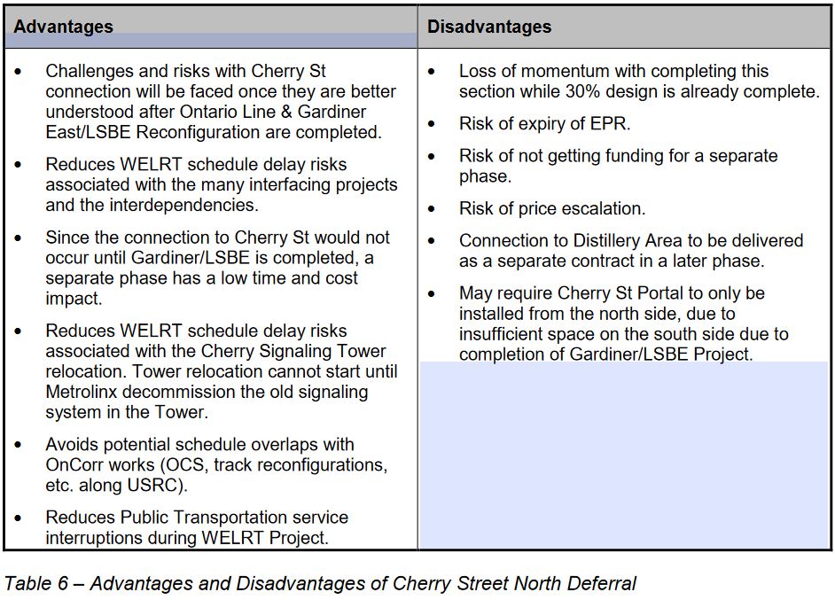
The deferral of the Cherry North connection is bound up in timing for Gardiner/DVP and Metrolinx work, but it presents the concern that a through service on Queens Quay from east and west will not be available until an uncertain future time, or may never be built. The advantages and disadvantages of this scheme, as stated in the report, are listed below.
Even though Distillery Loop and the future WELRT will be close to each other, a walking transfer would be needed to make the connection, and through service would be impossible between King East, Cherry and the Port Lands.
A related consideration for project phasing will be the Broadview Avenue extension that could provide a link from the east via Commissioners Street, but that is beyond the scope of this report.
There is no discussion of whether the extended project schedule, in part, attempts to minimize the spend rate while the City grapples with its financial problems. The flip side of that question is whether the project could be accelerated, or if competing work in the area makes this physically impossible.
Preliminary Design Business Case
Regular readers of this site will know that my opinion of “business cases” for transit projects in the GTA is not particularly complimentary. The entire exercise is one of monetizing every aspect of a project’s costs and benefits to determine if it is “profitable” in some greater sense. This has many flaws including the imputed value of various effects and the calculation of the benefit:cost ratio over a 60 year period.
The business case report for the WELRT is a long, rambling report that also contains material that duplicates (but not exactly) information in the Constructability Report.
The bottom line here is that in spite of all the calculations, the net benefit ratio for the WELRT project is below 1.0 indicating that the value of supposed benefits will be less than the cost of construction and operation.
What this analysis does not really address is that the waterfront project as a whole would not be practical if it relied on bus service in mixed traffic, and provision of a private bus access to Union Station would be at least as challenging as upgrading the existing streetcar tunnel. Provision of transit to enable a “transit oriented community” with minimal parking was and is fundamental to the waterfront plans. Like the over $1 billion spent on flood protection and opening of new lands for development, the WELRT is part of the cost of doing business.
The PDBC does include some information about demand patterns, and notes that if the Cherry North connection to the Distillery District is built, some projected demand between the new developments and downtown will flow via Cherry and King rather than via Queens Quay to Union. There is no mention of the role of a future connection to an extended Broadview streetcar via Commissioners Street and of the Ontario Line.
Questions Raised at Executive Committee
Deputy Mayor Jennifer McKelvie asked why this report only dealt with the Waterfront LRT and not the Eglinton East LRT as had been the practice in past updates.
Derek Toigo, the Executive Director of Transit Expansion, gave a garbled answer about Metrolinx conflicts with the EELRT both at Kennedy Station and at the proposed Conlins Road yard on Sheppard East. He implied that Conlins Road might be required for a maintenance facility for the Sheppard extension. This only makes sense in the context of an LRT extension east from McCowan, not for the proposed subway that would end there and which would be connected to the existing Line 1.
A report on various transit projects is expected in the next round of committee and Council meetings, and this will include the EELRT status update.
Councillor Fletcher asked where cars for the WELRT would be stored and maintained. Toigo did not know. A TTC rep jumped in and said that the cars would come from existing streetcar barns such as Leslie via the existing system. This has been well-known for years as the project has always been an extension of the streetcar network, not a free-standing rapid transit line. Less clear is the matter of fleet planning and whether the WELRT will require additional streetcars beyond the currently planned 264-car fleet by the time it opens in the next decade.
Fletcher also asked about the history of the WELRT and how it went from a high priority City project to languishing at the bottom of the priority list. Toigo responded with a limited history starting in 2018 (the period cited in the report), but the project goes back over a decade further.
There is a consistent problem with the quality of information provided by the Executive Director who might find it useful in future meetings to either be better briefed, of to hand off questions he cannot answer to staff who can.
History of the WELRT
Community groups have been working on many aspects of waterfront development including the WELRT for many years, certainly much longer ago than the 2018 date cited at the meeting.
2003: Central Waterfront Secondary Plan
In considering the Central Waterfront plan, Council incorporated a recommendation from the TTC:
The Toronto Transit Commission requests Toronto City Council to amend the Central Waterfront Secondary Plan by adding to Section 5: Making it Happen, of the report the following:
(2) District-Specific Transit Implementation Schedule Required Before Development Can Proceed
Because of the area-wide, integrated, nature of developing an effective transit network, transit implementation must be managed on a broader area-planning basis. It cannot be managed effectively through precinct planning, or a sub-area planning process. To achieve the objectives of the Central Waterfront Plan, a high level of transit use is required in each of the four development areas, and it
is essential that transit-oriented travel patterns be established from the outset. For this reason, the implementation of transit improvements will require a separate financial planning and approval process.For each of the four development areas, a staged implementation schedule, and accompanying financial plan for the construction and operation of transit facilities, will be required before development can proceed in that development area. This will ensure that high-order transit services are constructed at an early stage in the development process and that the transit-oriented objectives of the plan are achieved from the outset.
Central Waterfront Report at p 2
Council also included:
It is further recommended that:
(a) Council reaffirm the principle that transit is a core element of the future redevelopment of the Waterfront.
Later in the report:
The Central Waterfront Plan is a “transit first” plan. The importance of non-auto transportation options to the future development of the Central Waterfront cannot be over-emphasized. An expanded higher-capacity network of local and regional transit service, and cycling and walking networks must be provided to encourage non-auto travel and accommodate increases in travel demand. To build successful, vibrant communities, the Plan must also integrate land use and transportation planning principles which encourage shorter and fewer trips to take advantage of planned cycling and pedestrian networks.
[…]
This approach will require a strong commitment to public transit, including the provision of the necessary infrastructure, and measures to ensure that viable and competitive alternatives to discretionary automobile use emerge as part of the implementation of this Plan.
Central Waterfront Report at p 42
July 2006: Waterfront Revitalization Report
The East Bayfront will be a mixed use district with relatively high density. Public transit will be the primary mode of transportation.
[…]
East Bayfront will be developed based on a ‘transit first’ approach. The objective is to have accessible and frequent public transit in place upon first occupancy of the new community. This strategy should increase transit ridership, as residents will develop their initial transportation patterns based on having convenient access to reliable public transit. Local parking requirements may also be reduced by this approach. The East Bayfront community will be serviced by a new LRT route along Queens Quay East, which will extend the existing Queens Quay LRT east from Yonge Street, and connect to Union Station via the existing tunnel. Eventually, this route will also connect to Cherry Street and the Port Lands.
[…]
Public transit will be provided by a new Light Rapid Transit (LRT) line which will connect to the existing LRT along Queens Quay West. An Environmental Assessment is currently underway to determine the final configuration of the LRT, and this work is expected to be complete by the end of 2007. Construction could begin shortly thereafter, and is targeted to be completed in 2011.
Waterfront Revitalization Report at pp 36-38, 54
Financial Crisis and a New Mayor
2008 brought an international financial crisis that put many plans in jeopardy, but the blow to transit plans generally came with the election of Rob Ford as Mayor of Toronto. In 2006, David Miller was Mayor, and the Transit City plan had not yet been published (it came out in March 2007). The focus was on network expansion at moderate cost, and the WELRT fit with this approach.
Ford loathed Miller’s plans, and cancelled Transit City the moment he took office in December 2010. The Waterfront did not fit into Ford’s subway dreams, and the project limped along with funding only for planning work, but no construction.
October 2015: Waterfront Reset
By 2015, it was clear that Waterfront planning was falling behind the pace of development, and not just in the East Bayfront.
[…] staff have reviewed the broader waterfront transit context and have concluded that there is a clear need for a “reset”. Recent waterfront transit planning has been ad hoc and incremental, with the result that there is no larger comprehensive plan for a transit network that can respond to the rapid transformation that is occurring along the waterfront.
There has been significant growth in many precincts along the waterfront, including South Etobicoke, Liberty Village, Fort York, King/Spadina, City Place, South Core, and King/Parliament. Further, significant growth is planned for emerging precincts, including Lower Yonge, East Bayfront, West Don Lands, North Keating, Port Lands and the First Gulf site. There is currently a latent demand for transit south of Front Street as witnessed by transit loading on the King and Harbourfront streetcar services. King Street, for example, represents the most southerly continuous east/west transit line and is regularly experiencing near or at-capacity conditions through much of the weekday peak periods. The extent of latent and anticipated future demand creates an imperative for defining a long-term transit solution as soon as possible.
Against this backdrop, numerous individual waterfront transit projects that would connect to the existing 509 Harbourfront LRT exist in different stages of approval: some EAs are in progress (Port Lands, Lower Yonge); some EAs have been approved but not implemented (East Bayfront); and some EAs were started but never completed (Waterfront West).
[…]
As a consequence of not having a comprehensive transit network solution for the waterfront, there has been little progress in securing funding for new transit infrastructure in the area. Small amounts of committed funding exist in the City’s Waterfront Revitalization Initiative capital budget and from Waterfront Toronto’s projected land development revenues; however, no single waterfront transit project is close to being funded and implemented.
Waterfront transit is largely absent from the robust program of transit infrastructure investment currently underway and, to date, it is not under active consideration for any funding that may be available through existing Provincial and Federal government funding programs. This, in spite of the fact that both the Waterfront West and Waterfront East LRTs are ranked in the top five unfunded rapid transit proposals in the preliminary analysis undertaken by City Planning as part of the five-year review of Official Plan transportation policies (known as “Feeling Congested?”).
Waterfront Reset Report at pp 1-2
By this time, the projected cost had risen to $520 million. Note that this is still for a considerably simpler and shorter route than is proposed in 2023. However, the pressure for incremental development and cost containment is also evident.
The breakdown of the $520 Million East Bayfront LRT is as follows:
New eastbound passenger platform: $112 Million
Extension of Bay Street tunnel to Freeland Street: $156 Million
Surface infrastructure: $66 Million
Rolling stock: $36 Million
Queens Quay revitalization: $150 MillionAs part of the reset, staff would explore options to reduce East Bayfront transit project costs and/or develop East Bayfront transit incrementally. A review of options to ensure the project is not delayed indefinitely is warranted.
Waterfront Reset Report at p 9
January 2018: Waterfront Transit Network Plan
In 2018, Council was looking at a plan covering the entire waterfront transit corridor from Long Branch to Woodbine. The cost of the entire plan sat at about $2 billion, but with many caveats.
Initial preliminary (pre-design) cost estimate for completion of the entire Waterfront Transit Network are in the range of $1.980 billion to $2.310 billion in 2017 dollars. These costs are primarily based on 1% or less level of design, and do not include rolling stock. This estimate is subject to further design work, third party cost estimate validation, and availability of federal and provincial funding. This estimate does not include escalation, financing costs or the pricing of risk.
Waterfront Transit Network Plan at p 4
The scope of the plan reflected the need to placate Councillors whose wards included various parts of the waterfront whether they had sufficient transit demand for a full upgrade to LRT or even streetcar service. Southern Etobicoke beyond Park Lawn was flagged only for operational improvements such as transit priority signalling and auto turn restrictions, while the eastern leg to Woodbine had very low projected ridership.
Council had already approved funding for 30% design work on a connection between Exhibition Loop and Dufferin Street. This work has been underway, but is stalled due to conflicts with Ontario Line plans.
An important factor emerged in the travel demand forecasts: unlike traditional plans based on peak hour commuting, the waterfront plan had to consider transit’s role for other types of travel, notably recreational.
The travel demand analysis revealed two key factors beyond forecast transit ridership.
One, the greatest concentration of cultural, recreational and special event venues and destinations in the City is along the waterfront corridor. Trips to these destinations are not fully captured within the travel demand forecasts. Travel to these destinations occurs during peak and off-peak times, and has surging characteristics that periodically overwhelm the existing transportation network. Overall, it is realistic to assume that overall transit trips will be higher than forecast.
Two, in addition to transit, the model suggests that pedestrian movements within the lower Bay Street Corridor will more than double within the 2041 horizon. This will result from growth in Union Station passenger volumes, and increasing population and employment density within the lower Bay Street corridor and Lower Yonge district. It is important that pedestrians and cyclists are considered in the further analysis of the lower Bay corridor as there can be mutual benefits for all of these travel modes.
Overall, an extended TTC light rail transit service network along the waterfront would serve multiple roles – longer distance trips, local trips, recreational/cultural/special event-based trips, and connections to other sustainable transportation modes, providing a resilient and flexible transportation system for the 21st century.
Waterfront Transit Network Plan at p 7
In the same timeframe, the future of the Port Lands evolved with planned flood protection work and creation of a new Don River course and Villiers Island. The WELRT, original foreseen as ending west of Parliament Street, would now be the link to future development further east.
Key events still to come were the Doug Ford transit plan including the Ontario Line (April 2019) and the Covid pandemic (March 2020). Both of these would delay work on waterfront transit, albeit in different ways.

Is it indispensable to update the streetcar tunnel? Wouldn’t it be more beneficial to demolish the tunnel/shorten the tunnel and use it just for the Union Station loop? It would save a lot of money to have the crossing Queens Quay and Bay above ground and not underground. It might also benefit the whole streetcar network to extend the route from Union Station to King Street and close the tunnel section.
Steve: The problem lies at the north end, not the south, with the capacity of Union Loop which is overtaxed at times today, never mind with an eastern leg of the network. The connection at Queens Quay is relatively cheap to build.
Extending north on the surface presents a few serious problems. First, Bay Street would have to become effectively a transit mall given the space needed for platforms and the very large numbers of passengers transferring to and from the subway. I am not sure that the subway station has enough vertical capacity for that volume of passenger movements to and from the surface. Second, there is no place for cars to turn around. Any around-the-block scheme would add substantially to streetcar congestion.
(As for the advocates of double-ended cars, we have a fleet of fairly new single-ended vehicles. Deal with these rather than proposing fantasy mods to the streetcar system.)
LikeLike
This line will never get built by the city in the current financial environment…the only way it gets done is if the feds or the province take it on…which will involve another round of design…they should get on with it by requesting it be taken over by IO and Metrolinx now.
Steve: The last thing you want is Metrolinx and IO taking over the project. Look at their experience on Eglinton. They could not even manage to handle the rebuilding of Adelaide Street and the City had to take over the work to get it done in a reasonable time. As a fig leaf to prove that they are involved, they are doing utility and prep work for new track on York Street, and even that seems to be taking forever.
LikeLike
What I don’t understand is how this route seems to ignore that the Ontario Line will be built at some point. Villiers loop is somewhat close to the future East Harbour Stn but getting to the Ontario Line from any point on this route is not going to be optimal. Even [the] distillery is dead in the middle of 2 future stations. Why do Toronto transit developments not support each other by having reasonable connections?
Steve: In the future with the extension east to Broadview and north to East Harbour Station there will be a connection. It’s not part of this plan because eve getting to Cherry and Villiers is a stretch financially.
You have to remember that the Ontario Line stations are sited in part due to redevelopment considerations. Think of it as an urban version of the Greenbelt or a gerrymandered highway project.
LikeLike
$337 million for the Cherry north connection?! Does that include the cost of moving the watchtower? They excavated the Dufferin jog bypass for a fraction of that cost.
Steve: It includes a new tunnel under the rail corridor which is a substantial part of the total.
LikeLike
It would be much better if the streetcar connection between Union Station and Queens Quay is replaced by a movator.
Steve: This was examined, but it has major problems of capacity and the need to redesign the tunnel as an “indoor” space for passengers.
LikeLike
Pinnacle One Yonge, for 1 through 7 Yonge Street, is being designed for three primarily residential towers approved at 65, 80, and 95 storeys. At Yonge Street and Queens Quay East. Meaning they will NEED the Waterfront East LRT to get to an expanded Union Station loop.
Would be nice if the Waterfront East was finished BEFORE the three buildings, AND others going up.
LikeLike
I’m sorry to be blunt, but this is just unacceptably embarrassing. A plan well known for 2 decades, is hoping to finish the first of many phases of construction…10 years from now, if we’re lucky? To fill some slips, lay some surface rail, and improved a tunnel?
I know the current crop of politicians aren’t to blame, and finances are tight…but come on. That’s just outrageous.
I’m also flabbergasted by the supposed study that claims the cost/benefit isn’t worth it, I.e. that putting rail transit on waterfront east will never recoup its costs. *seriously?*. How flawed or paid off are the people doing these studies that this isn’t an obvious win?
Why is transit and transportation always an afterthought. Imagine if this was the sewer system. “Were just not confident that constructing this will turn a good profit. And it will take at least 5-10 years after the buildings go up to install”. But somehow that’s where we are…for critical infrastructure.
LikeLiked by 2 people
My view would be to run streetcar track down from Church through the proposed connection tunnel to Cooper (Lower Yonge Precinct Plan) and loop Waterfront East service via Wellington, York and King. If the Union loop and QQ/Bay connection happens it happens but right now it looks like nothing happens, at all.
Steve: I hold even less hope for the Church/Cooper connection than for the WELRT, so I would not count on it as an optional route.
LikeLike
Steve, I can suggest another acronym for the WELRT project, which is KISS.
I have been reading the Constructability Assessment. It is full of “Risks” & “Mitigation”. I never imagined that it could be so complicated. The “Risks” & “Mitigations” seem to be of two general types:
While filling in the Parliament slip is for re-alignment of QQE to connect to the new Cherry Street is understandable, lack of co-ordination was mentioned as there was no provision for LRT access!
At the hotel, I did not see any reason given for a need to fill in the Yonge Street slip except that it would provide a new entrance for the hotel on the east side. But, why? Would the hotel lose access from west-bound QQW if the new east portal and/or if the ROW blocked the way? I am sure a simpler & cheaper solution would be to move the portal entrance a bit further east and allow left turns to the existing hotel entrance as now – there would be no ROW beyond the portal entrance. Therefore, no need to fill in the slip.
Steve: The original design placed the portal east of Yonge, but this would require the tunnel to descend under an existing sewer that cannot be relocated. By shifting the portal west of Yonge, this is avoided. As for the hotel, the extended Yonge Street slip allows a reorientation from Queens Quay where the new portal will restrict access to the front of the building. The hotel’s entrance is a terrible, car-oriented design.
Of the three segments in the map, Segment 2 in the middle is the simplest and most straightforward part of the WELRT project. I am thinking that Segment 2 could go ahead of Segment 1 and Segment 3, especially considering funding required for Segment 1. The tracks could simply go around the portals. Meanwhile, the track can be connected immediately to Parliament Street, but shift to a new alignment when Segment 3 is ready. KISS.
WWLRT also seems to be held up by inertia.
Just some ideas for consideration.
Steve: The idea of building segment 2 first, or at least in parallel with other work, has been around for a while. I am not sure that bypass tracks around the portal really solves the problem because construction at the portals will make traffic operations difficult enough without having to deal with fixed lanes for tracks. As for Parliament Street, this has also been proposed before, but has problems with clearance at the rail corridor overpass north of Lake Shore as well as the geometry of a connection at King Street. It is really critical that the line east to Cherry and south into the Port Lands be built to serve development that will exist by the time “phase one” opens. A Parliament connection would take more capital spending, and in a worst case could trigger a delay of the eastern section.
I am no fan of the way this project has evolved and the effect of endless delays and a lack of prioritization while politicians troll for votes in suburbia.
LikeLike
While searching for “Harbour Street extension Toronto to Jarvis Street”, I found this instead about the QQE & Parliament Street revamp: BlogTO
The article has a further link to the WELRT. In all honesty, that article states: “If you’re expecting to see shovels in the ground immediately, please remember that this is Toronto, and it never works like that here.”
But, Steve, I could not find any info on the proposed Harbour Street extension. Is there a stated purpose? Do you have a link or map? Also, 1st time I hear of it, in comments above, a tunnel connection of Church St. to Cooper St.? I would not support that car-centric fantasy. Vehicular traffic attempting to enter the westbound Gardiner Expressway ramps clogs up all south-bound streets most of the day – a different solution must be found.
Steve: The Harbour Street extension has been part of the overall plan for the block of land from Yonge to Jarvis for years. The intent is to change the Yonge & Harbour intersection to a conventional crossing and to distribute traffic coming off of the Gardiner further east. It took me a simple Google search on “Toronto Harbour Street Extension” to get a link to the Lower Yonge Precinct Plan which describes the planned Harbour and Church Street changes. I don’t think that you looked very hard.
LikeLike
Steve, regarding the proposed Harbour Street extension, I did see the Lower Yonge Precinct Plan by Waterfront Toronto. No maps. For the record and for the convenience of readers, this was their plan in 2016:
1. Convert Harbour Street to two-way operations between York Street and Yonge Street.
2. Eliminate the eastbound Bay Street on-ramp to the Gardiner Expressway.
3. Shorten the eastbound Lower Jarvis Street off-ramp from the Gardiner Expressway.
4. Eliminate the Harbour Street S-curve at Yonge Street and normalize the Yonge Street / Harbour Street and Yonge Street /Lake Shore Boulevard intersections.
5. Provide an additional eastbound lane on Lake Shore Boulevard East from Yonge Street to Lower Jarvis Street.
6. Construct a new north-south street between Cooper Street and Lower Jarvis Street.
However, it was never updated since 2016, and since then development and land use changes along the proposed extension makes much of the Lower Yonge Precinct Plan doubtful. For example, Harbour Street has become the one-way eastbound off-ramp from the Gardiner Expressway for York, Bay, & Yonge Streets.
Steve: Thanks for the update. Your earlier comments implied you had never heard of the Harbour Street Extension and had not looked particularly hard to find info about it.
LikeLike
As I write, the WELRT has been in the news. Toronto Mayor Olivia Chow toured the waterfront yesterday and is pushing for $63 million funding for WELRT design work to be voted in Council today. As I write, about 4:55 pm, I do not yet know the outcome. There is no build money yet from the province and Ottawa.
Steve, yesterday afternoon I deliberately checked out, on location, Queens Quay at York, Bay, & Yonge Streets to see what was the terrain, an area I visit often. To me, there appeared to be plenty of room for the east LRT portal.
Of course, I could not see where the culprit sewage pipe is located, which ostensibly limits the east portal location, not at Freeland Street as previously proposed. However, cannot the sewage pipe be moved if necessary? Especially if plenty of digging is going on? What is its diameter, source, and destination?
From Waterfront Toronto:
Therefore, it appears that the location of the east portal vis-a-vis the sewer pipe is yet to be determined, and is not an insurmountable problem.
Steve: The shift of the portal from Freeland to west of Yonge goes back several years, pre-covid, as does the change to the hotel’s drop off area into what is now the north end of the Yonge Street slip. There is a CSO at Yonge Street too, and going under it, or moving it, is expensive and difficult. No, it cannot be moved, at least not at a cost that is worthwhile. It is much easier to shift the portal west and avoid the problem completely. During the portal selection study (2020), a $40-50m saving was cited, and that number will be higher now with inflation by the time we actually build something.
Queens Quay is generously wide in this area. Building Segment 2 of the WELRT ahead of Segment 1, with temporary track around the portals is quite doable.
Steve: Doable, but not ideal both because of the constrained space and potential conflict with construction at the portals as I already mentioned.
I do not see any need for a new entrance to the Westin Harbour Castle Hotel. It has been fine as is for over 30 years. Therefore, no need to fill in the Yonge slip.
Steve: The east portal will sit directly in front of the hotel. You seem bent on keeping the Freeland option, but that’s not workable. In effect, you are concocting an argument to suit your proposal.
As for connecting WELRT to Parliament Street, again problems cited. But, a Parliament connection is most logical, whether the WELRT track is temporary or permanent.
Meanwhile, a quick note about the WWLRT, linking Exhibition Place to Dufferin Loop, about 800 to 1000 meters. Held up by Ontario Line considerations, I ask, build the LRT and worry about Ontario Line later – some rejigging of track at Exhibition Place might be necessary, and maybe not.
Steve: Have you ever dealt with that gorilla Metrolinx? The province will not let the City build the Dufferin connection conflicting with their project at Exhibition.
I do not understand the aversion to temporary track, as I have suggested. It is not going to cost $millions.
Steve: Actually it will, but you have already convinced yourself that your scheme is the right one, so I am not going to argue further.
LikeLike