
Out of sight of most in Toronto, the mouth of the Don River has been transformed by Waterfront Toronto with earth moving and landscaping on a scale rarely seen in these parts. The work will shift the Don River’s course and provide floodproofing for a large area to be developed under the name “Villiers Island” after a street in the northern edge of the district.
Cherry Street will shift to the west the equivalent of a short city block, and the New Cherry will eventually have a branch of the Waterfront East streetcar service if the City ever gets around to financing and building it.
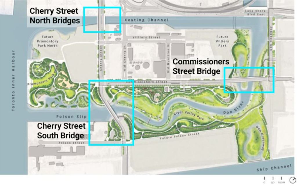
Three new bridges were built in Nova Scotia by Cherubini Metal Works. Waterfront Toronto has an article about the design process and, of course, many articles and photos of the overall project. The map below shows the positioning of the three bridges.
The bridges share a common design, but each is unique in its own way.
- The Cherry Street North bridges, one for road traffic and one for transit, will connect the New Cherry Street across the Keating Channel to a reconfigured Cherry and Queens Quay intersection. Eventually, there will be streetcars on a realigned Queens Quay East as well as south from Distillery Loop connecting to New Cherry. These bridges are red.
- The Cherry Street South Bridge is a road bridge over the future river connecting New Cherry to the existing road at Polson Street. This bridge is yellow. Depending on the route taken by the new streetcar service, there could be a loop somewhere north of the Ship Channel. If so, the Cherry South bridge will gain a transit twin like the north bridge.
- The Commissioners Street bridge carries Commissioners Street over the future path of the river. Because of its length, it is a double span. This bridge is orange. Like the Cherry South bridge, it could gain a twin set of spans for transit if trackage is ever extended east from New Cherry either to an extended Broadview Avenue or further east to Leslie Barns at Commissioners & Leslie.
The new river is not yet flooded and so there is water in the old Polson Slip west of the Cherry South Bridge, but the riverbed east and north of there is completely dry as work to prepare it continues.
Continue reading