
A recent comment sent me looking for service levels early in the TTC’s existence (post 1921), and I was pleasantly surprised to rediscover that this information is in a book, now long out-of-print, by John F. Bromley called TTC ’28. This book provides a view of the system when the electric street railway in Toronto was at its height.
In a recent presentation to the TTC Board, staff argued that the streetcars were an integral part of the growth of Toronto, but their viewpoint was comparatively recent, from the 1950s onward, and even that did not fully show the former extent of the transit network which was once almost entirely operated with streetcars.
I often get questions about the streetcar system as it was, and this article is intended to consolidate the bits and pieces in one place. The route histories will give some indication of why there is so much streetcar track in apparently odd places today. Remember also that the downtown one-way streets date from the 1950s when the DVP/Gardiner recruited several streets as on/off ramps to the expressway network and “optimised” them for use by motorists.
Information for 1928 is taken mainly from Bromley’s book. Other sources are Rails From The Junction by James V. Salmon, Riding the Radials by Robert M. Stamp, and The Toronto Trolley Car Story by Louis H. Pursley.
The following map shows TTC routes in August 1928. It was scanned by Pete Coulman from a guidebook, and the original scan lives on the TransitToronto website’s maps page.
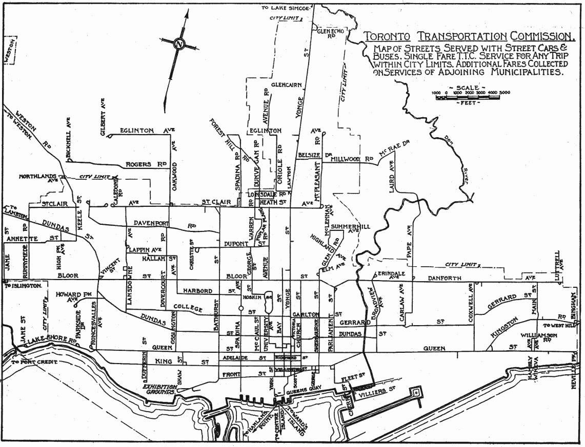
Only a few routes on this map are bus operations, generally small lines on the periphery of the system.
Serving Downtown
Anyone born in the past half-century is used to the idea that the Yonge-University and Bloor-Danforth subways (now known as Lines 1 and 2 respectively) provide the lion’s share of transit capacity into the core area, supplemented by the streetcar network and GO Transit. However, before the subways opened, their role was provided not just by streetcars on their namesake streets, but on parallel routes that fed into a common area. This was an essential part of service design not simply to spread out the network through many neighbourhoods, but because all of the streetcars needed to serve the core could not fit onto one street.
“Downtown” was quite different from the area we think of today, and much of the development was concentrated south of Dundas with areas to the north more residential than commercial. Construction of Eaton’s College Street store began in 1928, and it was thought to be a huge risk building so far away from downtown. The building is much smaller than original plans because of the combined effect of its location and the recession.
The land around the port and the railway corridor was used mainly for industrial purposes, and the large workforce in these areas required a lot of transit service. This land is now home to tens of thousands as the condo boom recycles the old city and changes travel demands.
Services to downtown in 1928:
- Bathurst cars ran south from Vaughan Loop at St. Clair to Front, then east to Frederick Loop at Sherbourne Street. (Although there was track linking Bathurst to the Exhibition ground, it was used only during special events such as the CNE or Royal Winter Fair.)
- Bathurst trippers (peak period cars) ran from Caledonia Loop on St. Clair east to Vaughan/Bathurst, south to Adelaide and then east to Church.
- Bay cars ran from Caledonia Loop on St. Clair east to Avenue Road, then south to Bloor, east to Bay and south to Ferry Loop (York & Queens Quay where the circular ramp from the Gardiner is today).
- Beach cars ran between Neville Loop on Queen to Sunnyside Loop west of Roncesvalles. Today the route is 501 Queen.
- Beach trippers ran from Neville Loop to King & Bay looping via Bay, Wellington and Sherbourne. Today’s 503 Kingston Road Tripper is a descendant of this route.
- Queen cars ran initially from Bingham Loop on Kingston Road (still in use by routes 502, 503 and 12) looping downtown via Victoria, Richmond and York. During 1928, service was extended east to Birchmount Loop, but streetcar service was cut back to the City of Toronto boundary in 1954 with the creation of “Metro Toronto”. Today’s 502 Downtowner is a descendent of this route.
- Bloor cars ran between Luttrell Loop (between Dawes Road and Victoria Park on Danforth) and Jane Loop (south side of Bloor opposite the foot of Jane Street).
- Danforth trippers ran from Luttrell Loop west to Church & Bloor, then south to Queen looping via Queen, York and Richmond.
- Carlton cars ran between Luttrell Loop and High Park over almost the same route as today’s 506 Carlton. College Street ended at Lansdowne, and so streetcars jogged south to Dundas to continue their trip west.
- Carlton tripper cars followed the east end route to Parliament, then jogged south to Dundas and west to loop via Victoria, Adelaide and Church.
- Church cars began at Christie Loop (corner of Dupont & Christie) and ran east via Dupont, Avenue Road and Bloor to Church, then south to loop via Front, Yonge and Wellington.
- College cars took a rather scenic route from Royce Loop (southeast corner of what is now Lansdowne & Dupont, formerly Royce Street) via Lansdowne, College, Bay, Dundas, Broadview, Gerrard, Carlaw, Riverdale and Pape to Lipton Loop (current site of Pape Station).
- Harbord cars also originated at Royce Loop, but took a different route into downtown via Lansdowne, Lappin, Dufferin, Hallam, Ossington, Harbord, Spadina and Adelaide to Church looping via Richmond and Victoria. Sunday service followed much of the College route from downtown to Lipton Loop. This evolved eventually into a consolidated Harbord route which was its form until 1966 when the BD subway opened.
- College trippers ran from Royce Loop to College and McCaul where they turned south and then east to York looping via Richmond, Bay and Adelaide.
- Dovercourt cars ran from Townsley Loop at St. Clair & Old Weston Road (the loop still exists as the western terminus of 127 Davenport) then later in 1928 from Prescott Loop (a small parkette west of the railway at Caledonia). They operated via Old Weston, Davenport, Dovercourt, College, Ossington, Queen, Shaw to loop via Adelaide, Crawford and King. This route served the Massey-Ferguson industrial district which is now the eastern part of Liberty Village. Peak period service extended via King looping via Church, Front and George Streets. The most substantial remnant of the Dovercourt car is the 63 Ossington bus which was once operated with trolley coaches taking advantage of the electrical system already in place.
- Dovercourt Trippers originated at Davenport & Dovercourt (reversing using the wye at that location as there was no loop) and followed the main route to King & Church.
- Dundas cars operated between Runnymede Loop (now the western terminus of 40 Junction) and City Hall Loop (from Bay via Louisa, James and Albert Streets). This route has operated through to Broadview Station (now as the 505) ever since part of City Hall Loop disappeared under the Eaton Centre development.
- King cars operated over essentially the same route as they do today between Vincent Loop (across the street from Dundas West Station) and Erindale Loop (one block north of Broadview Station). Peak service was extended in the west to Jane Loop and in the east to Danforth & Coxwell with some trippers looping downtown via Sherbourne, Front and Bay.
- Parliament cars ran from Viaduct Loop (now a parkette at Bloor & Parliament) south to Queen then west to loop via Church, Richmond and Victoria.
- Sherbourne cars ran from Rosedale Loop (at Rachael Street) south to King and then west to York and Front to Station Loop (Simcoe, Station and York Streets). Peak service operated east to Danforth & Coxwell rather than to Rosedale Loop.
- Spadina operated with double-end cars between crossovers at Bloor and Front.
- Yonge cars operated between Glen Echo Loop (east side of Yonge, just before the hill down to Hogg’s Hollow, the originally proposed name for York Mills Station) and Station Loop. Short turn services operated as far north as Lawton Loop (now a parkette on the west side of Yonge north of Heath Street) and AM peak trippers originated at Eglinton Carhouse (of which parts remain in the bus garage now recycled into a “temporary” bus terminal).
This is a huge number of routes that collectively linked the commercial and industrial core of Toronto to the residential neighbourhoods, some of which were comparatively recent “suburbs”.
The level of service was equally impressive. In the table below, numbers under “Two-Car Trains” give the number of trains (a motor car plus a trailer) operated followed by the total number of runs so that, for example, the Beach car has 44 runs of which 37 operated with trailers.
Route                 PM Peak      Two-Car
                      Headway      Trains

Bathurst                2'00"        3/30
Bathurst Tripper        5'00"        9/14
Bay                     1'15"
Beach                   2'30"        37/44
Beach Tripper           3'00"
Bloor                   3'00"        All 41
Carlton                 3'00"
Carlton Tripper         4'00"        14/17
Church                  4'00"
College                 4'00"        2/23
College Tripper         7'00"
Danforth Tripper        7'30"        7/10
Dovercourt              2'45"
Dovercourt Tripper      4'00"
Dundas                  2'00"
Harbord                 2'30"
King                    2'00"        31/54
King Rush               4'00"
Parliament              3'00"
Queen                   5'00"        16/17
Queen Tripper           5'00"
Sherbourne Tripper      2'45"        10/26
Spadina                 2'45"
Yonge                   1'45"        All 42
The West End and Suburbs
In addition to many routes listed above, a few were entirely “local” to their areas, and others were part of separate suburban network, the lines called “radials” that had been built separately from the “city” system.
- The Davenport route was a remnant of a longer route on the Toronto Suburban Railway, but by 1928 was reduced to operating a shuttle service from Bathurst to Dovercourt. It survived until 1940 when it was replaced by a bus.
- Lansdowne operated as two separate routes because of the railway level crossing (now an underpass) north of Dupont (Royce). The Lansdowne North route operated as a shuttle from St. Clair to the north side of the railway. Service from Royce Loop southward was provided by the College car weekdays and Saturdays, but there was a Lansdowne South Sunday service from Royce Loop to Dundas.
The TTC operated routes for York Township under contract.
- Oakwood cars operated from Oakwood Loop at St. Clair (still existing) north to Eglinton and west to Gilbert Loop (west of Caledonia Road).
- Rogers Road cars also operated from Oakwood Loop north to Rogers and west to Bicknell Loop (east of Weston Road).
- Lambton cars, a remnant of the Toronto Suburban Railway, operated from Runnymede Loop west to Lambton Park. The line did not carry well, and it was converted to a bus route in August 1928.
- Weston Road cars operated from Keele & Dundas north to Humber Street in Weston. This was another TSR line that originally had operated to Woodbridge (1914-1926). The line was converted to TTC gauge in stages, and for a time ended at a loop at Northland Avenue (at the City limits).
The Oakwood and Rogers routes eventually became trolley coach lines as part of what is now 63 Ossington, although Rogers Road has been extended and split off from Ossington for many years. The Weston Road route also became a trolley coach, although streetcar service remained as a peak-only extension of St. Clair until 1966. That extension was not possible until the opening of the “St. Clair Subway” under the Weston rail corridor in 1932, and the streetcars originally operated to Northland Loop. That is the reason why St. Clair cars were signed “Northland” even after they were extended to Avon Loop at Rogers Road.
Another leftover from the radial system was the line on Lake Shore Boulevard West.
- Mimico cars operated from Roncesvalles Carhouse via the old trackage on Lake Shore (pre-Gardiner Expressway) west to Stavebank Road, just east of the Credit River in Port Credit. In the fall of 1928, the city trackage was extended to Long Branch, and the “Mimico” route disappeared. “Port Credit” cars ran on the remaining “radial” line until February 1935.
Updated: I have been remiss when listing routes operating in 1928 by omitting the Toronto Suburban’s line to Guelph. This was not a TTC operation, but remained part of CN’s electric operations to the end.
The line began at Keele & St. Clair, but was abandoned in 1931. This electric railway was never extended into downtown and suffered from its “suburban” nature even though its terminus was on the CN corridor now used by GO’s Kitchener-Waterloo service. The small station building remained for decades after. A fragment of the line still sees streetcar operation as the Halton County Radial Railway museum.
The East End and Suburbs
Most of the services in the east end ran to the downtown area and they are included in the main list above.
- Coxwell cars shuttled between Danforth and Queen with Sunday/Holiday service extended via Queen and Kingston Road to Bingham Loop. This route exists almost unchanged today.
Service on Kingston Road east of Victoria Park was provided by the Scarboro radial car to a point east of Morningside Avenue where Kingston Road and Old Kingston Road diverge today. In late 1928, the line was double-tracked to Birchmount, the city routes were extended into Scarborough and the radial service operated from there east. Rail service ended in two stages: east of Scarborough Post Office in 1930, and the rest of the line in 1936 to allow highway widening.
The North End and Suburbs
The northernmost of the remaining streetcar lines is on St. Clair. In 1928, it operated from Caledonia Loop to Mt. Pleasant Loop at Eglinton, although service on St. Clair was also provided by the Bay and Bathurst cars west to Caledonia (see above). Eventually, the line was extended west to Keele Loop (replaced now by Gunn’s Loop) when the underpasses at Caledonia (1931) and at Weston Road (1932) opened. Caledonia and Prescott Loops were no longer needed.
By far the most extensive of the radial lines was the Metropolitan Division of the Toronto & York Radial Railway. This was not taken over by the TTC until 1927. Cars ran from Glen Echo Terminal north to Richmond Hill and Lake Simcoe with the line ending in Sutton. Service operated every 15-20 minutes during peak periods to/from Richmond Hill with some cars running through to Newmarket every 45-60 minutes all day. Cars to and from Sutton operated every two hours or so leaving from Sutton between 5:50 am and 10:25 pm with a running time of 2 hours and 25 minutes. The Lake Simcoe route was cut back to Richmond Hill in 1930.

Thanks for all the links, Steve!
Steve: You’re welcome! Your site is a trove of historical info.
LikeLike
Fascinating stuff Steve.
I was aware of some of this through discussions with my parents who lived in the area bounded by Lansdowne/St. Clair/Keele/Bloor from childhood through to 1952 – and also older members of my church who had lived in North York prior to WWII. Amazing to see what it looked like in so much detail.
One of the most frequently mentioned routes was the Toronto & York Radial Railway which ran up to Lake Simcoe. It was apparently quite an adventure in winter when the cars were heated by a wood stove stoked by the conductor.
You mention that the Lake Simcoe portion was cut back in 1930 – but I suspect it ran a few years longer than that (though perhaps on a reduced basis) based upon the ages of the people who spoke of it. For example, my Dad (born in 1922) holidayed on Lake Simcoe with Grandad and Nana for many years – and neither of them drove so I suspect they traveled northward and back on this route – possibly as late as 1938.
Steve: I have checked several sources, and the last day of service north of Richmond Hill was March 16, 1930.
LikeLike
I got a kick out of that slightly under 2 minute headway for the afternoon rush hour on Yonge. Today’s headway bunching problem didn’t begin yesterday. One evening in 1947, I counted a total of 8 trains lined up on northbound Yonge, at Eglinton. Admittedly, that was a record of sorts; but 3 or 4 trains was common. Cars didn’t drive on the tracks at that part of Yonge; the drivers knew better.
The Sherbourne Tripper, which you mention, was, in spirit, a rush hour attempt to produce an early version of the Downtown Relief Line. It allowed people to bypass Yonge and the jams at Bloor and Yonge. Some things never change; but the TTC and the city politicians, seemed to actually be on top of future necessities in those days.
One last point. Auto traffic is horrendous in the GTA today; but don’t let the smaller volume of the pre 1950 era lull you into thoughts of a driver’s nirvana. For example, driving from downtown to Leaside or North Toronto was stop and go in the evening rush hour, especially on Glen Road, in Rosedale, until the Mt. Pleasant extension opened.
LikeLiked by 1 person
Bromley’s TTC ’28 and Fifty Years of Progressive Transit show up regularly at the Toronto Transportation Society’s Memorabilia Night, which is the May meeting. It’s an auction system, and sometimes the bids go too high, while other times you can snag a bargain. I have spare copies of both of these, as well as a supposedly author-corrected copy of Pursley’s Toronto Trolley Car Story. Another book that described the foundation on which, even today, the TTC is built, is Hood’s The Toronto Civic Railways.
These can be fascinating reading, and a basis for some interesting exploration. For example, once I took my bicycle and followed the route of the old Toronto Suburban Railway’s Crescent route, trying to imagine the early electric streetcars winding along these residential streets.
While I’m on the topic, are there any good references for the Belt Line railway? That’s another long-gone public transportation project that still shapes its area of the city today.
LikeLike
Those “two-car trains” (large Peter Witt motor car and a trailer) would be the equivalent length of one Flexity Outlook streetcar. However, they needed three employees. A driver and conductor in the motor car and another conductor in the trailer car.
Most of the single streetcars would have had a driver and conductor before they switched over to a single person to handle both driver and conductor operation (pass-as-you-enter). The conductor also handled sales of tickets, in addition to collecting fares and issuing transfers.
The buses had pay-as-you-enter, but I know that the PCC had to be pay-as-you-enter. Don’t know when the Peter Witt’s single cars switched to pay-as-you-enter.
Steve: The conversion to PAYE was a rolling change that took place over many years on various types of equipment. Some of the change was a matter of attrition as the PCCs replaced older vehicles, but the last of the two-man cars remained until after the Yonge subway opened in 1954.
LikeLike
The photos in TTC ’28 are a treasure trove.
LikeLike
Those were the days when the TTC and streetcars ruled the roost! Autos were not so much for the average person and everybody was not hell bent on getting one car length ahead of the next guy. Tracks were held in place by removable stones that offered a bone shaking ride for autos that tried to beat others. So too did many people live near their work rather than travel far and add to their work day. Gradually, people are returning to that as they fill up endless condo towers everywhere.
I remember those days when there were just a few bus routes and streetcars everywhere. Look at how the city was covered by many routes that changed direction as they made their way along. This cut down on transfers. Harbord was a route that did this more than any other and was perhaps not fully understood as to its purpose as it zig-zagged along connecting north/south to/from east/west routes over and over again.
Things have never been the same since Metro was created and suburban sprawl spread out everywhere. The TTC has been in over their head ever since.
LikeLiked by 2 people
Regarding Ken Mahy’s comments:
The entire Metropolitan Line was ‘abandoned’ in the spring of 1930; and, after discussions with local governments, the section between Glen Echo and Richmond Hill was reopened as the North Yonge Railways, later that year. The latter used suburban equipment, one of which is at the Halton County Museum, instead of the large interurban, radial cars of the Metropolitan. The small, rural communities north of Richmond Hill saw no need to retain service, thanks to two opposite forces; the automobile and the depression. The tracks were torn up with unseemly haste in some places, but the right of way your dad rode still exists in places north of Newmarket.
The holidays that your family continued to take in the thirties were either made possible by buses that partially replaced the radial line or steam railways that provided service to Jackson’s Point for another two decades.
LikeLike
Copies of Bill Hood’s book, The Toronto Civic Railways, can still be purchased from George’s Trains in Markham at reasonable cost. TTC ’28 and Fifty Years of Progressive Transit can often be found on eBay (never accept the second unless all of the separate track and route maps are included). Sadly, the title of my second book cannot be applied to the latest fifty years.
LikeLike
1928 would mean the inter-urban bus service Gray Coach Lines would have been only a year old, and growing.
LikeLike
The next fifty years book could be called “The Fall and Rise of the TTC”.
(True, the “and rise” is wildly optimistic, but I like to be optimistic…)
LikeLike
Not sure if you want to publish an ‘advert” but there are currently 4 second hand copies of John Bromley’s book for sale on the wonderful book site: abebooks.com – all quite cheap too.
LikeLike
One negative aspect of the two-car streetcar trains was that usually the front motor car would fill up very quickly, while the trailer would have seats and space available. I can it happening on the routes where the trains would appear very infrequently, like on Bathurst with only 3 two-car trains out of 30 runs.
That “front filling up” occurs to this day, where the front half of buses and streetcars are crowded, but there is still seats or standee space available in the back. At least with the conductor being by the rear exit doors, passengers could board the streetcars without waiting for egressing passengers.
LikeLike
Steve, thanks for the post. It is interesting how we have both improved (the subway lines), we have taken a step back in other areas (streetcar lines in 1928 are now served by buses.)
LikeLiked by 1 person
While this is certainly true I wonder if there are any former streetcar lines that “deserve” streetcars today. The subway clearly changed travel patterns and some of the ex-lines are, I think, now fairly low ridership – as we know from the subway, subway, subway crowd, one can over-build and this also applies to streetcars.
Steve: It is ironic that the most likely candidates are the former radials, notably the Richmond Hill line. However, this gets us into the whole question of how to deal with demand north of Steeles both to the core area, midtown and within York Region itself.
LikeLike
Whoa.. I have to check at home, but I swear I bought TTC ’28 at the Halton County Radial Museum for a $1.99 on Canada Day! There were only a few copies.
LikeLike
It’s weird hearing about routes and looking at a map with no stations. They act as anchor points for pretty much all our existing bus and streetcar routes today.
LikeLike
I thought the Harbord cars used Ford Drive, one block east of Old Weston?
Steve: The Toronto Suburban’s Davenport line operated via Ford Street, but that line was cut back to run from Dovercourt to Bathurst in 1923 by the TTC. In early 1924, the TTC built new track via Old Weston Road to Townsley Loop. This was used initially by the Dovercourt car, but when it was replaced by the Ossington trolley coach in 1947, Harbord took over the run to Townsley.
LikeLike
Don’t forget the unlisted services, like the free bathing cars. Can you imagine that ever happening today, in this era of paranoid parenting?
Steve: I left out the special services like the bathing cars as my main interest was to show the complexity of routes serving the core area before there were subways.
LikeLike
Before 1927, the “main” entrance to the Canadian National Exhibition were the Dufferin Gates. The Exhibition streetcars from the east would have used King Street East and West to Dufferin Street, to reach the Dufferin Gates. Gradually, the Ex expanded eastward towards the New Fort York (Stanley Barracks). The Princes’ Gates were completed by 1927, and the King Exhibition streetcars now was able to use new tracks as well to reach the exhibition grounds by 1927 and 1928. So those were still new streetcar tracks on Bathurst Street going south of Front Street and eventually west to the CNE, in 1928.
LikeLike
Can’t grasp from your lists which was the streetcar that ran west along Davenport Road, past Dovercourt – and Salem Avenue – and probably past Oakwood, too, when I visited grandparents in the late 1940’s.
Deb
Steve: Depends on what part of the late 40’s you’re talking about. Up to December 7, 1947, it would have been the Dovercourt car, but this was consolidated with the Harbord car from Dec. 8, 1947 onward. Neither car ran past Oakwood as they came up Dovercourt to Davenport, then headed west.
LikeLike
Not wholly accurate, sorry, not sure where your 1927 date came from.
The Eastern entrance trackage opened in time for use during the 1916 CNE. KING-EX operated a split service, some cars to Dufferin Loop, some via Bathurst to the south end of the bridge over the railways – in those days it was located on a southwestern slant leading to PRW through Fort York’s grounds. After 1923 all KING-Ex cars ran to the Eastern Entrance Loop. But, that’s not the entire story.
TRC, and later TTC, ran several other routes into the Eastern Entrance, almost all late evening return services only. These were BATHURST-EX (1916-1921), BROADVIEW-EX and WINCHESTER-EX (both 1916-1922), PARLIAMENT-EX (1916-1917 only), and YONGE-EX (1916-1941 and again from 1947-1949), and from 1922 onwards the latter route operated full trailer trains. (As an aside, if you think that YONGE-EX was an oddity, sometime I must relate the story of the YONGE BATHING CAR which, in the latter years of its operation, also used trains!)
Finally, there was the COLLEGE EAST TRIPPER-EX route operating at what were described merely as “busy times” in 1923 only.
Cars running from 1931 onward used the new route via Bathurst and Fleet St, but contunued to use the original loop trackage in the CNE grounds, which was rather primitive. 1931 was also the year that the FORT route began service (amusingly not until after the trackage through Fort York was discontinued). That lasted until the loop was completely revised (to that with which we are all familiar) in 1933, lasting, with revisions, to 1995.
LikeLiked by 1 person
Thanks DavidC. Ordered one of the copies for sale yesterday. Looking forward to having this book 🙂
LikeLike
John Bromley: please entertain us with your stories of the YONGE bathing cars….
LikeLike
Re: TTC ’28, it should be known that there were two printings. The first used a reasonable paper quality for the time (it was 1968), with a matte type of page finish. The second printing, which was done without my permission and surprised me at the time, was published on a more glossy paper style and the photos were degraded to the point that many are quite muddy. That was the result of the publisher copying the book page by page to make new page mockups, rather than coming to me to retrieve the original page mock-ups and half-tones. I don’t think that there is any notation in the second printing that it WAS a second printing, although I could be wrong as I don’t have a copy of that version.
Re: Fifty Years of Progressive Transit, there were three printings. The first was split into hardcover and softcover versions, and because of the cheesy way ERA went about binding them they can suffer to the point of spine cracking and falling apart. The second and third printings were strictly hardcover versions. The maps in all versions included a bound lot of 6 route maps and 6 corresponding track maps, one pair per date (210901, 230701, 360501, 450213, 540330 and 710901) and on the back page was a summary of the number of active car types each year from 1921-1971. As well, there should be a folded subway track map (undated but including the original Yonge St crossovers and track on SPADINA as far as Wilson Station). Some tables in the book are copied directly from my original hand-printed versions that I submitted to ERA, as they were too cheap to have them type-set. At least they are clear to read.
If I ever get it finished, my final work is a complete database of routes, roster and operations (at least where full data was available) in perhaps excruciating detail, starting from 1861 and running more or less through to the end of the twentieth century. I’ll leave it to younger folk to carry that forward as I’ve lost interest in the more modern aspects. It corrects much of the data in the two Pursley books, and offers up a number of hitherto unknown routes (or perhaps I should say variations of routes in most cases) that were operated in the late 1890s and early 1900s). I spent thousands of hours going through all of the old newspapers on microfilm at TPL, something no one had done before, and it was a very revealing exercise. Unnamed at present, perhaps I’ll call it ‘140 Years of Trying Hard to Please Everyone and Failing Miserably.’
Lest anyone think I make money out of any of these publications, guess again. Nada. The last will eventually be published online, free to everyone.
LikeLike
Remember, you asked for it!
The main BATHING CAR routes were fairly well-known: BATHURST (for many years actually BATHURST-ST CLAIR), BEACH, CARLTON, DOVERCOURT, DUNDAS and KING). Lesser known were DANFORTH, LANSDOWNE SOUTH (later, just LANSDOWNE), PARLIAMENT, QUEEN and, perhaps least known of all, YONGE.
The YONGE BATHING CAR first operated in 1910 to service the Don Bathing Station (on the Don River just above Winchester St originally, running between North Toronto Station (after first wyeing at Price St and backing north), then via Yonge, Carlton, Parliament and Winchester to Sumach Wye, returning virtually by the same route later in the day (cars did not lay over; deposit and return trips were two separate operations, as will be the case throughout). This continued through the 1915 summer season, with very minor route description changes which I won’t bore you with. In 1916, the route was changed at the eastern end to run via Carlton, Parliament and Broadview to wye at Danforth using TRC rails.
From 1917 through 1922, the 1916 route was followed with the exception that cars started and ended their trips in North Toronto at the recently-opened Woodlawn Wye. Service in 1922 was of course through the auspices of the fledgling TTC and, despite the fact the Witt trains were now assigned to YONGE, a few older ex-TRC cars were allocated to the YONGE BATHING CAR.
In 1923, TTC changed both the routing and equipment servicing it. Cars were no longer assigned from Yorkville Carhouse (now closed) but instead ran out of the new Eglinton Carhouse via Yonge, Bloor, Prince Edward Viaduct (it wasn’t known as Bloor St in those days), Danforth and Broadview to Erindale Loop and return. The 1924 through 1926 service was extended yet again and now cars operated from Glen Echo Loop to Erindale Loop (one reference was located that stated the starting point was Glencairn Wye but no supporting evidence was found). Peter Witts were assigned and, while no specific evidence has been found to substantiate trailer operation, Ray Corley remembered being told by Lou Pursley that some were assigned at busy times. Lou provided valuable reference material with his two books, but Ray stated on many, many occasions that Lou often “wrote from memory” and a few things slid through in his books that were (to quote) “not as accurate as he (Ray) would have liked” (referencing wrong dates, mostly, or missing material). Mr Corley was a stickler for accuracy.
The final two years of service in 1927-28 saw a major shift in routing and destination. The ferry docks on the newly opened Queen’s Quay were now in use, and cars operated from Glen Echo via Yonge and Front St to the new bridge over the railway lines between Yonge and Bay (to access Bay St), then via Bay and Queen’s Quay to Ferry Loop (whose location shifted frequently in the early years of cars to the docks, although the bathing cars only ever operated to the familiar loop at York St).
And, perhaps now we shouldn’t try and take over Steve’s blog with any more of my long-winded responses!
Steve: In case you should see a bathing car pass by, here are some tickets: Front and Back. These are clearly for outings to the Islands taking one to Bay and Front Streets. They are from a collection of tickets and transfers that was maintained by Lou Pursley’s father at the TRC and continued by his son up to the late 1950s. When I worked at Hillcrest many years ago, they were taking up a couple of filing cabinet drawers, and there was a housecleaning. Being in the right place at the right time, I prevented them from going into the garbage. I dread thinking what else might have been thrown out that I did not catch.
LikeLike
Fascinating about the YONGE BATHING CAR service from Glen Echo to Erindale Loops. I assume that service was again for possible swimming purposes along the Don River, which is interesting because Hogg’s Hollow was always a popular spot for swimming as I assume points north of Danforth would have been as well. Try doing that today in the Don…….yech…..
LikeLike
Hogg’s Hollow may well have been popular but it was not a free city-operated “bathing station” with proper supervision for the local children. The TRC and TTC were only concerned with people in their own operating area.
LikeLike
Halton County Radial Railway has a stock of TTC’28 on hand. Confirmed with archivist and Gift Shop Manager.
LikeLike
Louis Pursley was, of course, the one person who saved TTC historical data that would have been lost in the mists of time otherwise. If he made a few mistakes, that is a small price to pay for the two wonderful books that he left us.
LikeLiked by 1 person
Bathing cars mentioned a few times by Matt Galloway on Metro Morning. They got someone reminiscing about his experience having to walk home after missing the return car from Sunnyside.
LikeLike
One thing for people to remember when they advocate for “radial bus lines” that go from the 4 corners to the downtown like the streetcars used to is that they were laid over a very frequent grid system and with only a couple of exceptions they made only one or two turns. They were used to provide additional capacity parallel to Yonge on Bay and Church. Yonge could not accommodate any more service.
LikeLike
One really interesting thing found in TTC ’28 were the draft drawings of a “high end” radial car that was planned before the Great Depression scuttled a number of projects that could possibly have entrenched streetcar lines, including out into the burbs, to an even greater extent than we have now. For one thing, if the idea had taken off for higher capacity radial service, it may have dramatically changed the scope and concept of the Yonge Subway (hints can still be seen in some of the proposals as late as the 1940s). Added to that the possibility that such bus routes as LEASIDE, and even service extensions similar to York Township could have happened in East York as well could have seen successful streetcar operations. Of course, we will never know.
LikeLike
One thing I’d really love to see done, and this would be something for those “younger folks” to take on, would be an interactive electronic version of the route and track maps. It could allow you to choose different snapshots in time to turn on or off individually or overlaid for comparison using different colours, much like turning routes on and off in NextBus or similar. (It wouldn’t need individual routes split, just the entire service map by year.) I’ve found it a bit difficult to compare the various maps sometimes because they were drawn to varying scales and geographic vs schematic formats. You could also have the ability to zoom in to areas of special work, or have buttons to click at the locations where detail drawings were available to pop up. Hopefully this could be done on a geographic format map.
When I said “younger folks” I wasn’t excluding myself, BTW. Figured I should clarify that! Unfortunately, I lack the necessary skills and time though.
Steve: The system was changing constantly in the early years, and a one year increment might miss some interim configurations!
LikeLike
I find it interesting that the destination signs for the streetcars were a mix. Usually they were the minor streets that they looped at. For example, the KING streetcars had destinations at VINCENT and ERINDALE. Other routes, however, had the major streets, for example, ST. CLAIR had KEELE and EGLINTON. BLOOR had strange destinations, JANE in the west, but DANFORTH in the east, even though Luttrell was the loop.
Why does the 512 ST. CLAIR still have KEELE as its west terminal destination signage, when GUNNS ROAD should be the destination? Will the new Outlooks use KEELE or GUNNS ROAD on its electronic signs?
Steve: I wouldn’t call “Jane” a strange destination. It is a major street just like Dufferin or Bathurst. There was a “Luttrell” exposure on the Witt and PCC roll signs, but “Danforth” was the common usage. Oddly enough, both “Luttrell” and “Danforth” were quite remote on the rolls from “High Park”.
By the time the CLRVs came along, the use of obscure side streets as designations was no longer common. “Bingham” on Kingston Road became “Victoria Park”. “Neville Park” survives probably because there is nothing else it could logically be called.
Also, the 514 Cherry cars are supposed to be signed “Distillery” as in the “Distillery District”, but the Flexitys show “Cherry via King” instead. This is a left hand, right hand problem, one of many within the TTC.
LikeLike
Further to David Cavlovic’s comments; it seems to me, in very long retrospect, that the TTC should have considered not lowering the boom on any streetcar lines that seemed to be duplicating their shiny new subways. The downtown highrises were already going in, and it shouldn’t have been difficult for the planners to project a denser future. Today, Dupont, Church, and Harbord would take a great deal of pressure off the TTC as it exists.
Steve: At the time the Bloor-Danforth subway opened in 1966, the TTC’s policy was that all streetcars would be gone by 1980 concurrent with the opening of the Queen Subway.
LikeLike
Didn’t know where to add this comment … but I figured in an old school, old map posting it should do ok …
When I used to live in the Beaches … I always wondered why TTC poles dot a section of Woodbine north of Queen on the west side … was there either trolley bus or streetcar service here? or is it simply the poles are there to deal with TTC infrastructure below? (I think that’s kind of the case on Adelaide, no? where they installed new poles but no track.)
Steve: There are a few places where there are feeders that do not follow streetcar routes. The ones on Woodbine run north from a substation on Queen and west to Coxwell via Eastwood Road. The feeders on Adelaide link west to Bathurst from a substation on Duncan Street.
LikeLike
The TTC website and Nextbus all say the 514 destination is Cherry via King. I guess that is the official destination while the name of the loop is Distillery Loop, like how the 502’s destination is Victoria Park, but the loop is Bingham Loop.
Steve: For what it’s worth, here are the destination signs listed in the Service Memo:
Obviously the new exposures for the older cars would not exist unless the TTC decides to make new roll signs for them. Hence the dash cards. But the Flexitys are supposed to show “Distillery” as part of their sign.
LikeLike
This wouldn’t be the first time that the destination signs in the field don’t match what the TTC advertises. I find that to be rather frustrating as a record keeper, but I haven’t heard too many complaints from customers.
LikeLike
City of Toronto Archives, Fonds 1231, f1231 it2148 – Christie Street looking north over Davenport Road July 9, 1914 – This photo clearly shows a single set of track along the south side of Davenport Road turning to the west side of Christie Street. No paving anywhere, both streets are dirt. This picture was documenting the grading and widening of Christie on the hill north of Davenport. My particular interest in this corner is that I lived for many years from childhood on Christie at the top of the hill.
Later, we see a Davenport streetcar running as far east as Bathurst. See City of Toronto Archives, Series 71, s0071, it3231, Davenport Road, looking east from Bracondale Hill Road, concrete being poured for streetcar trackbed June 23 1924. This is just west of Christie. Also s0071 it3205 – Davenport Road, looking east, from Christie Street, building TTC track June 10 1924.
Other than the one photo, I have not seen any reference to streetcars on Christie Street. Can anyone clarify?
Steve: I believe the first photo is mislabelled and is actually at Bathurst Street. Compare your image with this image labelled as being at Bathurst. Here is another view looking north (mislabelled south) on Bathurst to Davenport. Common to all of these is the way the road dodges left (west) north of Davenport and the single track turning east to south onto Bathurst. Other views are of Hillcrest Racetrack (now Harvey Shops), southeast across the interesction, and south from the hill.
I still have fond memories of my Mum taking us kids to Centre Island on the PCC streetcar from Christie Loop at Dupont, which took us straight to the Ferry Docks. In fact, I pointed this out yesterday evening to my niece’s paternal grandmother as we were passing by.
Another fond memory was a dead of snowy winter trip with my Dad on the Bathurst car southbound from St. Clair (Vaughan Loop). The car was a Witt, and the driver had a small wooden stove by his feet, as well as a nice pile of firewood to last his shift. Try this today! As for the passengers, we were all squeezed together like sardines, everyone dressed in heavy wool coats. Cozy!
LikeLike