A Contrarian’s View of Bathurst/Dufferin RapidTO

Recent newspaper articles and editorials extol the virtues of the RapidTO projects on Bathurst and Dufferin Street, and portray those who object in a less than flattering light.

The urgency of transit priority action for the 2026 FIFA games combines with portrayal of transit priority as an absolute good before which all objections must fall. The word “NIMBY” is thrown about to denigrate residents and businesses in the affected areas, but this is no substitute for hard data proving, or not, that the RapidTO proposal really is “the better way”.

For decades, I have advocated for better transit service in Toronto. Transit priority measures are one, but not the only, factor that can improve transit for riders. Quality and quantity of service are also key, and yet the TTC has a tendency to place most blame for their shortcomings on external factors. To be sure traffic congestion is an issue, and Toronto is already at a point where in some locations and times there simply is not enough capacity to go around. This is not a case of some omniscient transit god or AI bot “parting the waters”, but of a recognition that this can only happen by restricting or eliminating competing demands for road space and time.

Another major factor is financial. Even pre-covid, the TTC faced limits on its operating funds and only grudgingly added service on routes. Recent announcements of “improvements” often hid the fact that the added vehicle hours left scheduled frequencies unchanged, but only offset the effects of congestion.

Service reliability and vehicle loading are key factors from a rider’s perspective, but the TTC uses metrics that bury day-to-day conditions in averages and give a generous interpretation to the concept of reliable vehicle spacing. It is no secret that TTC service management leaves a lot to be desired, and some transit “priority” schemes are are really more about keeping transit out of motorists’ way than they are to speed rider journeys.

The problem is compounded by motorists who regard attempts to corral them as an affront to their virility, but whose actions only recently have been reined in through the use of Traffic Wardens.

The City Transportation Department’s outlook is that if they make cars move faster, transit benefits too – a rising tide lifts all boats. This model collapses when there simply isn’t enough room or time for all vehicles. Some must be able to go first, and some will simply have to go away.

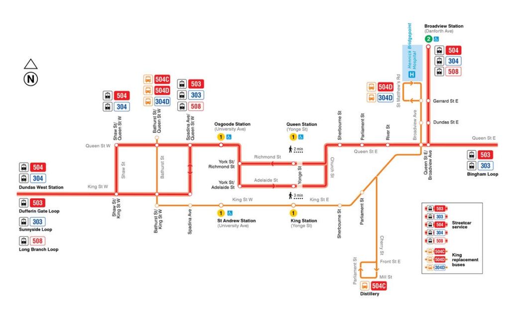
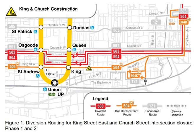
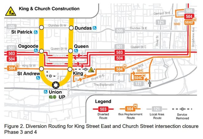
The King/Church construction diversions illustrate another aspect here: the concentration of transit service and traffic in locations that cannot sustain it, especially when transit, running in bunches, overwhelms intersection capacities with many closely-spaced arrivals and turns. TTC has redirected part of the diverting service (504 King) away from Spadina to Shaw so that left turns are spread out, and King/Spadina will further improve on its own when the 511 Bathurst cars return to their usual southern terminus at Exhibition Loop in late June. The east end of the diversion, at Church, does not have the same options for spreading out routes and turning issues.

In the FIFA context, we do not yet know what sort of service the TTC plans to operate, and how it will manage both the vehicle and passenger volumes at major transfer points including not just Dufferin and Bathurst but at other locations such as Union Station and major intersections enroute.

Continue reading

504 King Diversion Revised

Updated May 16, 2025 at 3:50pm: The TTC has now published a map of the revised diversion routes.

In response to congestion problems for streetcars turning on and off of King and Queen Streets at Spadina, the TTC has modified the route of 504 King.

Instead of running west via Queen, Spadina and King, the 504 will now divert via Queen, Shaw and King. The 503 Kingston Road car will continue to operate via Spadina and King to Dufferin Loop.

The TTC has not yet updated the information on its King-Church diversion page as of 1:30pm May 16, but plans to do so. On-street signage will also be changed. The diversion map and information appear on several different pages, and it will be interesting to see if the TTC changes all of them.

Updated 3:50pm with revised diversion map for routes 504/304, 503/303 and 508. Not shown are routes 501 Queen and 511 Bathurst.

This reduces the peak streetcars/hour attempting to turn east-to-north at King and Spadina from 23 to 17, and west-to-south at Queen and Spadina from 13.5 to 7.5 (plus occasional 508 Lake Shore cars). Off-peak service is almost the same as peak service and so these numbers do not change much during those hours.

Numbers eastbound at King will be further reduced in late June when the 511 Bathurst cars, 6.5/hour, resume their normal route to Exhibition Loop, and 508 Lake Shore cars, 3/hour at peak, are suspended for the summer.

Updated: Now that the map has been published, it is clear that the 504C/D buses will continue to loop at Bathurst, and service on King from Bathurst to Shaw will only be provided by the 503 car.

Problems remain further east on the diversion with all of the 501 Queen, 503 Kingston Road, 504 King and 508 Lake Shore cars making turns to and from Church, Richmond, Adelaide and York, a total of about 23 per hour. There is also severe traffic congestion on Adelaide, but it is not clear how much of this is caused by queuing streetcars, and how much due to traffic volume and road capacity.

The option of using Victoria Street for the link between Queen and Richmond/Adelaide is not available because of Ontario Line construction, even though this would have separated the streetcar diversion from the busier Church Street.

See also:

Service Analysis of 7 Bathurst Part III: Headways & Travel Times 2024-2025

This article is the final part of a review of route 7 Bathurst where the City of Toronto and TTC are currently studying the implementation of reserved bus lanes from Eglinton to Bathurst Station north of Bloor Street.

See also:

Data presented here are from all weekdays from January 2024 to April 2025 for three screenlines on Bathurst:

  • Barton Street just north of Bathurst Station
  • Just north of Eglinton Avenue
  • Just south of Steeles Avenue

These show headway behaviour at terminals and at the dividing line between the portion of Bathurst proposed for RapidTO bus lanes (south of Eglinton) and the portion that will not change. Travel time behaviour is shown for the entire route, as well as for the segments north and south of Eglinton.

In each chart, both the median value (50th percentile) and 85th percentile are shown. The latter value shows, generally, the degree to which the peaks lie above the median, while filtering out the worse case values in the top 15 percentiles.

Median headways over the 16 months are fairly consistent and lie near 10 minutes, the scheduled level of service. There value drops only in the period from November 2024 to March 2025 when additional unscheduled service operated during the morning.

The 85th percentile of headways stays close to the median during most off peak-periods and at terminals, but it drifts higher at Eglinton both ways showing how small variations leaving the terminals can grow enroute. In peak periods and directions, the 85th percentile is often well above the median value showing erratic departures from terminals.

Travel times along the route vary substantially from about 35 minutes in late evenings to over an hour in the peak periods. Although the length of the trip varies a lot by time of day, the 85th and 50th percentiles stay close to each other indicating that the travel times are consistent within each period. There is a day-of-week effect visible in repeating peaks in the values on midweek days. This is seen on several routes across the system, and shows how a formal schedule does not face the same conditions every day.

Not included here are the weekend data which, as shown in Parts I and II, are not as “well behaved” because of schedule shortcomings, very wide variation in the spacing of departures from both terminals, and a high level of short turning in an attempt to keep buses on time.

Although Toronto proposes reserved lanes on part of this route, this will not improve behaviour outside of the target area. Travel time savings would occur in the peak period primarily south of St. Clair.

Continue reading

Service Analysis of 7 Bathurst Part II: Travel Times in April 2025

Updated May 14, 2025 at 6pm: A section is added at the end of the article showing the time spent at both the Steeles and Bathurst Station terminals.

In Part I of this series, I reviewed headway reliability on 7 Bathurst during April 2025. This article turns to travel times along the route, an important issue relative to claims made for the potential benefit of reserved bus lanes.

See also:

In Part III I will review historic data back to January 2024 to see how, if at all, conditions have evolved over the past 16 months.

Continue reading

King/Church Diversion Observations May 12, 2025

Today was the first weekday of the King/Church construction diversions. I watch things evolve via NextBus through the morning peak, and then visited King/Spadina during the PM peak. A caveat: Mondays are light traffic days. There was no Gardiner backlog at all on Spadina. Later in the week will likely be more challenging.

During the AM peak, the service on 504 King and 503 Kingston Road did not load properly, and many vehicles were clumped together. This took quite a while to unscramble, and there were big service gaps. The 504 buses also ran in packs and huddled together at Wolseley Loop, at one point six of them representing about 20 minutes worth of service at the scheduled headway. The peak period did not encounter queueing frequently at points where streetcars turn because of many wide service gaps. When a bunch of cars arrived, they queued one by one awaiting their turn, but then the intersections would open up again even though in theory there should always have been transit service waiting.

In the PM peak at King/Spadina, the major sources of traffic were pedestrians, cyclists and transit in that order. I observed that the traffic signal cycle time was 110 seconds (1’50”). This means that there are 32.7 opportunities (3600/110) per hour for a turn to/from Spadina. The nature of the intersection is that only one streetcar can make the turn per cycle.

The combined scheduled service trying to make the EtoN turn per hour at King & Spadina in the PM peak is 23 streetcars.

RouteHeadwayCars/Hour
503 Kingston Road8′7.5
504 King Car10′6.0
508 Lake Shore20′3.0
511 Bathurst Car9′6.5
Total23

Stir in 12 510 Spadinas straight through northbound on a 5′ headway. When there is a 510 (or any other car) serving the farside NB stop it blocks any car waiting to turn off of King. In a 45 minute visit, I saw this happen four times, and one car missed two turning opportunities because of closely-spaced Spadina cars blocking the stop.

Depending on arrival times and bunching, more vehicles can queue up here than there are cycles to accommodate them. This was under probably the best general traffic conditions we will see.

There were traffic wardens, but they left just before 5pm. The biggest problem was pedestrians blocking turning streetcars which do not have a protected turn phase EB on King. There is a WB advanced green because autos are forced to turn off King here, but there is no advanced green for eastbound streetcars.

The large volume of riders transferring from eastbound streetcars to buses adds to the already substantial pedestrian volumes at this intersection.

The Traffic Wardens did not reliably ensure that streetcars got “first dibs” on turning, and after they left, pedestrian interference became worse.

I boarded a 504 King eastbound at about 5:10. There was congested traffic over the route across to Church especially on Adelaide and it took over 15 minutes to get from York to Church. Some people complain about space “wasted” by bike lanes, but it was the left turn lane that was almost always empty. Some traffic used it to scoot around stopped streetcars!

The severe congestion can be seen in the TransSee maps of service for 504 King and 503 Kingston Road below. The tracking lines for the diversion area are almost horizontal for an extended period. Note that the problem is mainly eastbound (lines reading bottom to top).

I rode a King car east from Spadina and it took a very long time to emerge from the diversion. The car went from 6 minutes early at King on Spadina to 11 minutes late at Queen and Church. Note the length of time spent approaching King and Spadina inching along the street about one carlength at a time. Other locations where the car crept along are also clear in the tracking data.

Tracking data for car 4634. Source TransSee.ca.

Among the problems enroute were:

  • Congestion on Queen thanks to stopped vehicles and construction in the curb lanes.
  • Autos infilling Adelaide Street eastbound leaving no room for a streetcar to merge from York Street onto Adelaide. We were eventually rescued by a Traffic Warden.
  • Extremely slow progress across Adelaide thanks to a traffic backlog from Church Street.
  • Extremely slow progress on Church Street thanks to a traffic backlog from Queen Street. My car actually fouled the Church/Adelaide intersection as it was unable to complete the EtoN turn in more than one traffic signal cycle.

Ridership on the car was very light and most people got off when the car turned off King onto Spadina. They transferred to the King shuttle buses which were running irregularly and often bunched. These buses were also trapped in the traffic queue eastbound to Spadina of streetcars waiting to turn. (In the chart below, the size of the dot represents the degree of crowding on the vehicle.

Tracking data for 504C and 504D shuttle buses May 12, 2025, 4pm to 7pm. From TransSee.ca.

For those who want to watch the wandering streetcars and buses on NextBus, here is a link. This will open a combined display of routes 501, 503, 504, 510 and 511. The map can be scaled to zoom in to the area of interest. Displays of operating charts on transsee.ca are free for TTC streetcar routes.

Over coming days I will keep an eye on service performance over the diversion, and once a few weeks’ data have accumulated will delve into the details.

Service Analysis of 7 Bathurst Part I: Headways in April 2025

Toronto plans to implement reserved bus lanes on Bathurst Street between Eglinton and Bloor. The project is notionally in support of future service to the FIFA World Cup events in 2026, but there is a good chance that they will permanent. Substantial travel time savings are claimed for this change, but the overall question must be of how service behaves on the route and what the RapidTO red lanes will add.

Part I of this series reviews headway reliability (vehicle spacing) and travel times in April 2025. Part II will review travel times in April 2025, and Part III will look at historical data going back to January 2024.

The scheduled service on 7 Bathurst is not as frequent as on other corridors where reserved lanes have been added. Weekday service has been every 10 minutes operating with articulated buses for the past two years. Weekend service was slightly more frequent, but operated with standard sized buses until September 2024 when it changed to artics and a 10 minute headway at all hours.

Another change in September 2024 was an increase of terminal recovery times, partly offset by a reduction in scheduled travel times, during most weekday periods.

Not shown in the schedule summaries is additional service from November 18, 2024 to March 28, 2025 using spare operators. These trips operated with standard sized buses between roughly 7am and 1pm. The effect of these will show up in Part III of the series.

In the detailed review, it is clear that weekend service on 7 Bathurst is much less reliable than weekdays. In the tables below, note that scheduled travel times are considerably less on weekends than weekday midday and early evening. This is reflected in shorter terminal layovers and many more short turns on weekends.

Continue reading

King-Church Construction and Traffic Effects

Updated May 5, 2025 at 12:50pm:

The TTC now has a web page with details of the changes for the first phase of the construction and diversions. This includes a map showing the diversions to west of Bathurst rather than just downtown. I have added this in the body of the article.

May 5, 2025 at 1:40pm:

Information about the 304 King and 303 Kingston Road night services has been added.

May 5, 2025 at 1:55pm:

The TTC has confirmed that overhead upgrades on King Street East and on Sumach/River will be completed before the King/Church track work end, and streetcar service will resume in September.

May 5, 2025 at 4:30pm:

I asked the City if it thought the intersections used by diverting streetcars and buses could handle the volume of traffic. They replied, but didn’t add much. See the end of the article for the exchange.

Major changes are coming to downtown streetcar routes on May 11 with the next schedule change. This will accommodate a combination of water main replacement, track reconstruction and streetcar overhead upgrades mainly at King and Church. Work is expected to require diversions until the October schedule change on Thanksgiving weekend. Streetcar service is expected to return with the September schedule change on Labour Day weekend.

The effects of work an King and Church have been known for some time through the Annual Service Plan and through a City report on the project. (The original report and recommendations were amended at the recent Council meeting to lessen the effect of various proposed lane closures.) Service levels have been published via the electronic version of schedules used by trip planning apps. The information about vehicles/hour at various locations is taken from those schedules.

(As an aside, the TTC website has still not been updated to include the 2025 Service Plan even though it was approved by the Board in January.)

With the concentration of transit service through various intersections, and the added complexity that most vehicles will make turns at these locations, there simply will not be enough capacity even under ideal conditions. It is no secret that “ideal” is a word rarely appropriate for transit operations downtown thanks to the lack of robust traffic management and real transit priority.

In past years, the diversion of services from King Street around the TIFF street fair created problems for transit travel times and reliability, but this lasted for a brief period. The planned diversions for King/Church will last through the summer.

Many of the water mains in the “old” city have been in service for over a century. Other parts of King Street have seen renewal, occasionally on an emergency basis following a break and sink hole.

The special trackwork at the King/Church intersection has been in bad shape for some time, and was overdue for replacement. Previous reconstructions were in 1983 and 2003. Other competing construction projects got in the way, and the track conditions have worsened year by year. There are many patches, and a well-deserved slow order unlike the standing practice even at freshly rebuilt junctions.

This intersection is also old enough that it predates the era of panel track construction where pre-welded sections are trucked in and assembled on site. This replaced the older style of tracks assembled piece-by-piece and often not welded robustly if at all. TTC has not yet been through its entire inventory of “old” track given the 20-30 year cycle depending on the level of service, wear, and disintegration at intersections.

Other work planned for this period of suspended streetcar service is the reconstruction of overhead on King and on the Distillery branch for pantograph-only operation.

Closing King & Church for an extended period concurrently with the Ontario Line construction at Queen & Yonge will add to the traffic snarls downtown. The City talks about using Traffic Agents to manage key intersections, but whether they provide enough people at enough places at enough times remains to be seen.

Routes Diverting off of King Street

Three routes are affected: 504 King, 503 Kingston Road and 508 Lake Shore.

The 504 King service will be broken into three sections:

  • A 504 streetcar service between Broadview to Dundas West Stations operating via the same route as 501 Queen between the Don Bridge and Spadina.
  • A 504C bus shuttle from Wolseley Loop south on Bathurst and east on King terminating at Broadview & Gerrard.
  • A 504D bus shuttle from Wolseley Loop south on Bathurst, east on King and south on Sumach to Front & Cherry. Buses will loop via [to be announced] and will not serve Distillery Loop.

The 503 Kingston Road service will be changed so that its western terminus shifts from York Street to Dufferin Loop. Cars will follow the same route as the 504 King via Queen from the Don Bridge to Spadina, then shift south onto King to follow the pre-diversion 504B route to Dufferin.

508 Lake Shore cars will follow the same route as 504 King.

Night Service Changes

  • The 304 King night car will operate every 20 minutes over the same route as the daytime 504 service diverting via Queen and Spadina.
  • A 304D night bus will run every half-hour over the same route as the 504D bus from Wolseley Loop to Broadview & Gerrard.
  • The 303 Kingston Road night car will operate every 20 minutes over the same diversion route as the 304 King night car, and will operate as it does now to Sunnyside.

The maps below are from the City Report about this project originally published in February. An updated map for the first phase has been added later in the article.

Source: City Report at p. 5

For part of the construction period, King/Church will be impassible even to the replacement bus service and it will divert south to Wellington and Front.

Source: City Report at p. 5

These maps do not tell the whole story because another set of construction diversions will overlap the King/Church changes until the next schedule change in late June.

Although water main work at Bathurst/Fleet/Lakeshore is now complete, track work continues there and on Bathurst Street further north. 511 Bathurst streetcars will continue to divert east via King to Spadina looping via Adelaide and Charlotte. The 511B shuttle bus will be shortened from Wolseley Loop at Queen to an on-street loop via King, Portland and Richmond to Bathurst Street.

509 shuttle buses continue operating between Exhibition Loop and Queens Quay Loop at Spadina. 510 streetcars continue operating to Union Station.

The combined effect of the diversions will be greater than during the total meltdown of King service in 2024 when all cars diverted north via Church to Queen because volumes of other routes (510 Spadina, 511 Bathurst and 501 Queen) will be added to the King services, and more intersections will be affected over a wider area.

Updated May 5, 2025 at 12:50pm:

The TTC’s project webpage has a consolidated map of the diversions for the first phase of the work.

Continue reading

RapidTO Dufferin and Bathurst Streets: Public Consultation May 2025

In anticipation of transit demands for the FIFA games in June 2026 as well as general route reliability, Toronto proposes to install transit-only lanes on Bathurst (Eglinton to Lake Shore) and Dufferin (Eglinton to Lake Shore) Streets. Consultation sessions for these projects will be held through May 2025 both online and in person.

Updated Apr 28, 2025 at 1:40pm: Corrections to the Bathurst Street info have been added thanks to responses from the project team.

Updated May 7, 2025 at 10:10am: Links to the presentation decks and maps have been added for both projects.

Bathurst Street

  • Virtual public meeting on May 12 from 6:30 to 8:30pm
  • Drop-in events at
    • Harbord Collegiate on May 10 from 11am to 3pm
    • Humewood Community School on May 14 from 4:30 to 8:30pm
  • Consultation materials:

Dufferin Street

  • Virtual public meeting on May 13 from 6:30 to 8:30pm
  • Drop in events at
    • Stella Maris Catholic School on May 15 from 4:30 to 8:30pm
    • St. Mary Catholic Academy on May 20 from 4:30 to 8:30pm
  • Consultation materials:

Additional details and registration links for the online sessions are on the project web sites linked above.

The consultation sessions will be interesting, especially to see whether the FIFA games will be used to bulldoze transit proposals that might not otherwise be approved.

Implementation is planned for fall 2025 subject to Council approval.

Only overviews of the proposals have been posted at this time, but I will update this article when more details are available. The overviews are summarized beyond the “more” break below.

Continue reading

512 St. Clair Traffic Signal Delays

With Toronto’s Congestion Management Plan in the news, we hear about various ways to improve the movement of cars and, oh, by the way, maybe speed transit vehicles too. Toronto talks a lot about “transit priority” but this more often means giving transit vehicles the leftovers, the spare time that can be shaved at some locations from competing traffic, not absolute priority for transit vehicles.

This shows up particularly where transit vehicles have a dedicated lane, but they must wait patiently while other traffic, typically left turns, gets out of the way. This has the perverse effect of making transit slower particularly when combined with the “double stop” effect of farside stops. At these locations, the nearside space a stop would normally use is occupied by a left turn lane, and traffic in that lane has first claim on a green cycle.

Two routes with this as a near-standard stop configuration are 510 Spadina and 512 St. Clair. The Spadina car only recently returned, and I will leave comparative analysis of bus and streetcar operation there until more data have accumulated. A preliminary look is not complimentary to the streetcars because, unlike them, the buses are able to combine waiting for green signals with loading passengers.

On St. Clair, streetcars returned in Fall 2024. This article reviews tracking data for March 2025. In brief, a common situation along the route is that streetcars spend more time waiting at intersections than they do serving stops once they cross to a farside platform. The traffic signals are not organized to favour streetcar movements, and the configuration with farside stops is counterproductive.

To be fair, one cannot simply throw a red signal in front of cross traffic every time a streetcar appears as this will affect both auto and pedestrian crossings that require a minimum time. When both the St. Clair and Spadina lines were designed, a concern was the frequency of streetcar service and the high probability that there would always be a streetcar demanding priority. However, the larger Flexity cars combined with TTC service cuts makes this claim less valid.

Pre-emptive streetcar signals could be challenging at some locations, but there is the separate issue of timing of the phase for left turning autos. Should it come before or after streetcars are allowed to cross the intersection? Streetcar-only phases are only provided at some locations on Spadina where cars are turning across traffic lanes, but not for through movements. There is a streetcar-only phase at Lansdowne and St. Clair westbound, but otherwise left turning auto traffic always has priority.

A related problem lies in TTC’s glacial streetcar speeds through special work which would require a lengthy transit phase to allow streetcars to clear intersections on Spadina with streetcar junctions. With streetcars crossing on the shared north-south green, this does force motorists to wait for streetcars to get out of their way.

The data on St. Clair show a common pattern: streetcars spend more time waiting to cross intersections than they do serving the farside stops. They may operate in their own lane, but the combination of farside stops and signal design works against transit operations. This has implications for the soon-to-open “LRT” lines on Eglinton and Finch.

If we are not prepared to give transit vehicles true priority over cars, how do we expect to attract more riders to the system and, in theory, reduce overall road demand?

The remainder of this article describes the methodology behind my analysis and shows the behaviour at individual intersections along St. Clair.

Continue reading

Service Analysis of 512 St. Clair: January-February 2025

This article reviews the behaviour of service on 512 St. Clair during the first two months of 2025. This period was marked by an intense snow storm in mid-February that left many transit routes in disarray thanks to poor snow clearing.

Updated Mar. 21, 2025 at 10:30pm: The service chart for February 12, 2025, the first of the two major snow storms, has been added to this article.

Updated Mar. 22, 2025 at 1:00pm: Detailed charts of headways and travel times for February 12, 2025, have been added showing the consistency of travel times along the route even though headway quality deteriorated through the evening due to bunching.

The typical problem on four-lane roads was that snow was not removed to the curb causing parked cars to foul the streetcar tracks. Despite streetcar lines being “Snow Routes”, the signs were little more than decorations. The oft threatened but rarely practiced removal of cars for proper clearing did not occur, and some snow/ice banks remained until they eventually melted. Delays for blocked service occurred repeatedly well after the storms.

Another common problem was the absence of breaks in windrows (ploughed snow banks) at stops that lasted weeks after the snowfall. A few special cases had problems that were not addressed:

  • Where a street had permanent curb lane installations such as bump-outs for loading zones at stops, a windrow would be ploughed separating the streetcar lane from the waiting area making entry and exit from cars difficult, dangerous and in some cases impossible.
  • Where a bike lane occupied the curb lane, there would be a windrow between the streetcar and bike lanes blocking transit access.

While the City is officially responsible for snow clearing, the TTC was noticeably silent on a critical issue of operational reliability and passenger safety. They talk a good line about “safety”, but here, in a real crunch, the TTC did nothing beyond pleading by press release with motorists to not block the tracks.

The 512 St. Clair cars run in reserved lanes on a wider-than-usual Toronto street, and snow clearing was much less of an issue for them. Looking over the two-month period, we can see the benefit of a clear, protected right-of-way when many other routes were snarled or inoperative thanks to parked cars.

St. Clair is a relatively short route running between Yonge Street (St. Clair Station) and Keele Street (Gunn’s Loop). It loops through St. Clair West Station underground. In theory, this should provide four points — the two termini and the midpoint at St. Clair West both ways — where service could be regulated easily. Actual headway data show highly erratic service even during the pre-snow period.

By contrast, travel times along the route were consistent, with only small variations thanks to the storm, indicating that the snow was not a major problem. Of course, with a reserved lane, the TTC’s favourite chestnut about “congestion” could not be blamed for headway problems.

The charts in this article show both the travel times and headways (spacing between vehicles) for 512 St. Clair in January and February 2025, as well as detailed charts for specific days.

Continue reading