
A recent X/Twitter thread began with a claim that the streetcar system suffers from slow operation because of closely spaced stops, specifically below 100 metres. I made a short reply showing the average spacing for each route, but have now generated charts showing all routes in detail.
There are only a handful of stops spaced closer to or below 100m, and so the claim that this is a source of much delay is easily disproved. The question then is what the typical spacings are, why, and how much “efficiency” could be obtained by eliminating some of them. I do not attempt to answer that question here, but simply present the actual stop spacing data so that there can be informed debate.
The TTC’s design goals for stops are set out in the Service Standards:
2.4 Surface Stop Spacing
Surface stops should be designed in accordance with the TTC’s Technical Criteria for the Placement of Transit Stops. When the locations of stops are being planned for a route, it is necessary to strike a balance between the competing objectives of passenger convenience, operating efficiency, safety and community impacts. In general, increasing the number of stops on a route results in shorter walking distances for passengers but it also slows down service. To achieve a proper balance, the TTC will place bus stops in accordance with the standard presented in Table 2 [below].
Service Classification Stop Spacing Range Streetcar 300 – 400 metres Bus – Local 300 – 400 metres Bus – Express (Tier 1) 650 – 1,000 metres Bus – Express (Tier 2, Limited Stop) 650 – 1,000 metres Bus – Express (Tier 2, Local/Express) 650m for express portion;
300 – 400m for local portionBus – Community Flag stop
It’s important to remember that Toronto streets are not laid out on a repeating grid as in some cities, and one cannot simply stop at “every second street”, or whatever layout works. Existing pedestrian circulation patterns, transfer points, major origins/destinations all play a role in defining a “good” stop location. This is even more of a problem in suburban areas with longer blocks and poor opportunities to access transit stop from “nearby” (as the crow flies) neighbourhoods.
Methodology
The stop distances for each route have been taken from the GTFS versions of the schedules published regularly by the TTC. These are used by trip prediction and planning apps to understand the layout of the system. In a few cases where current operations do not match the historic route layout (e.g. 501 Queen, 504 King, 512 St. Clair), I have used older data sources from a period when routes operated normally.
Introduction
The average stop spacing on most routes under 300m, and this implies (per the standards) that some stops could/should be removed. That is not as easy as it looks unless an existing gap is very short.
For example, 200m spacings are common, and if one stop is removed this makes a 400m gap. One cannot simply shift a single surviving stop to a midway point if that means taking service away from a transfer point or other high demand location. There is also the question of where street crossings (signals or PXOs) exist. Another concern is pedestrian-hostile spaces such as grades, bridges and underpasses. Each location must be reviewed, not simply expunged with a formulaic scheme.
Removing an existing stop that is not at a traffic signal has less potential to save time because streetcars will not be caught by poor or missing transit signal priority schemes.
In the following charts, the length of the horizontal lines shows the spacing of each stop from its predecessor on the route. Note that routes are not shown at the same scale because some have a few very widely-spaced stops.
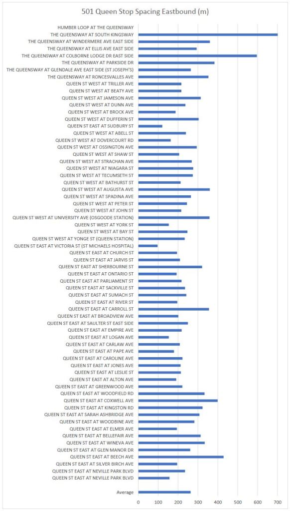
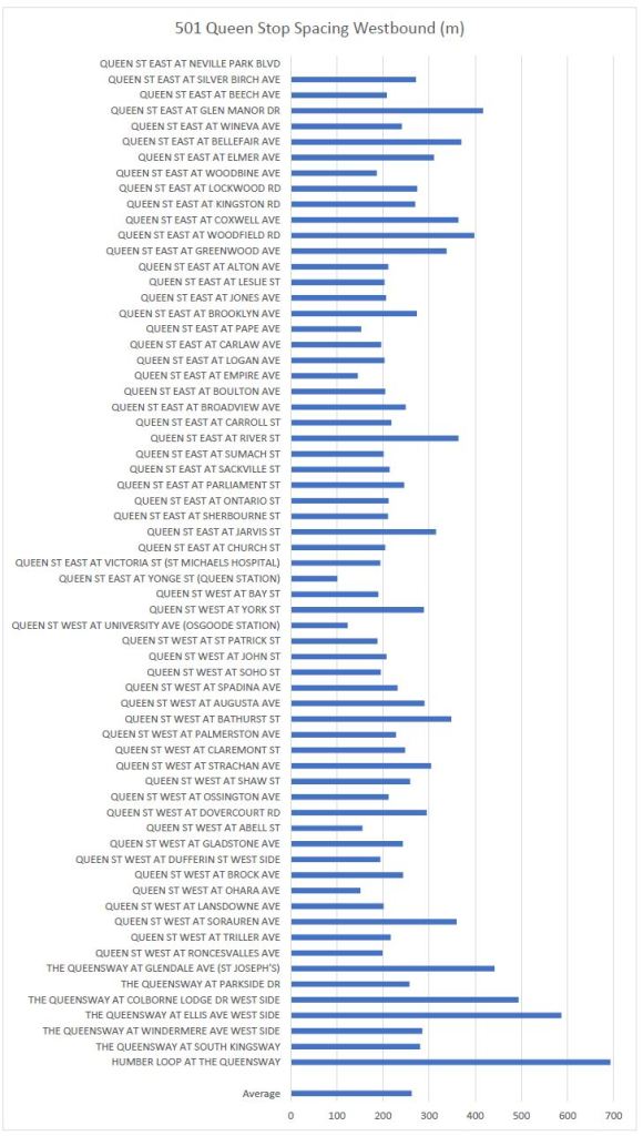
501 Queen
The shortest stop spacings on Queen are in the Church-Victoria-Yonge segment at St. Michael’s Hospital. The longest gap is between the South Kingsway stop and Humber Loop.
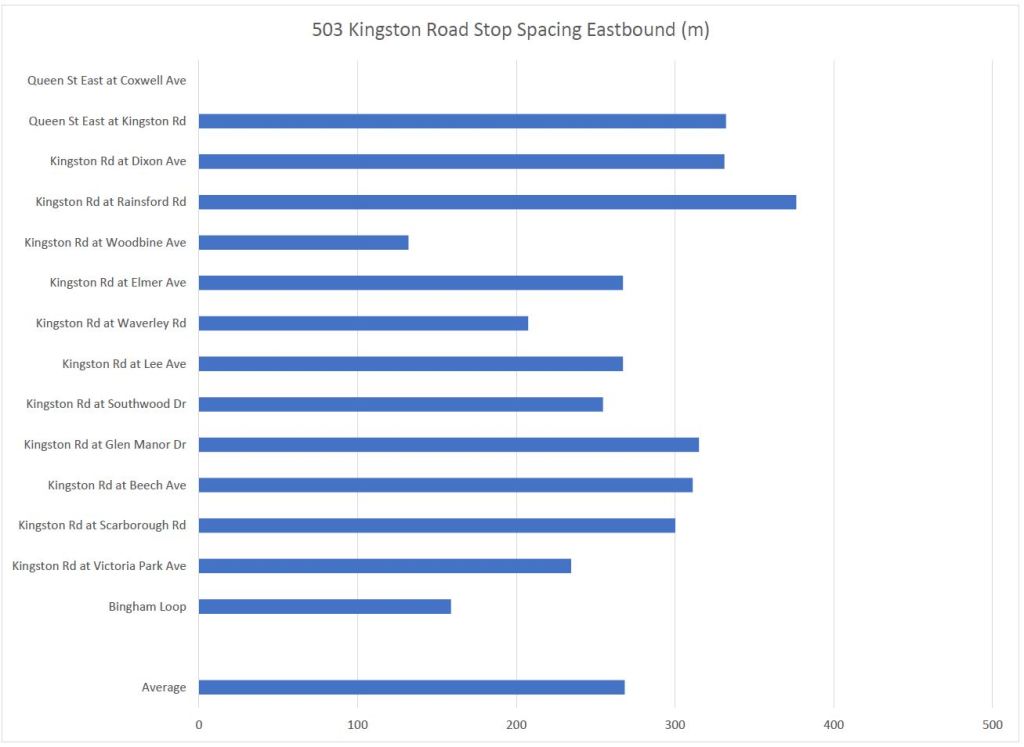
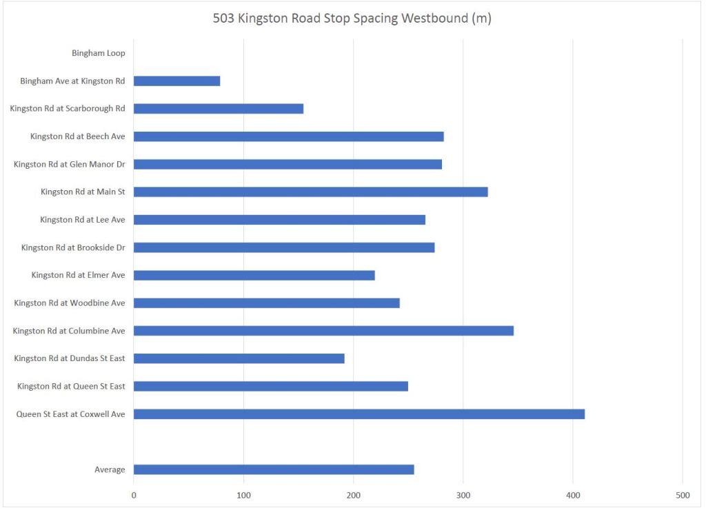
503 Kingston Road
These charts cover the unique part of route 503 Kingston Road east of Coxwell. The average spacing is roughly 250m. The shortest is at the exit from Bingham Loop where there is a stop both in the loop and southbound on Bingham at Kingston Road.
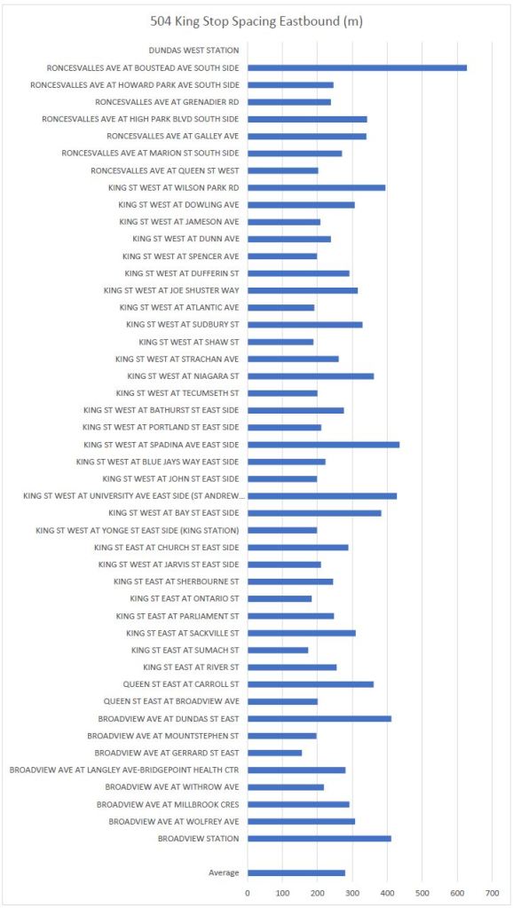
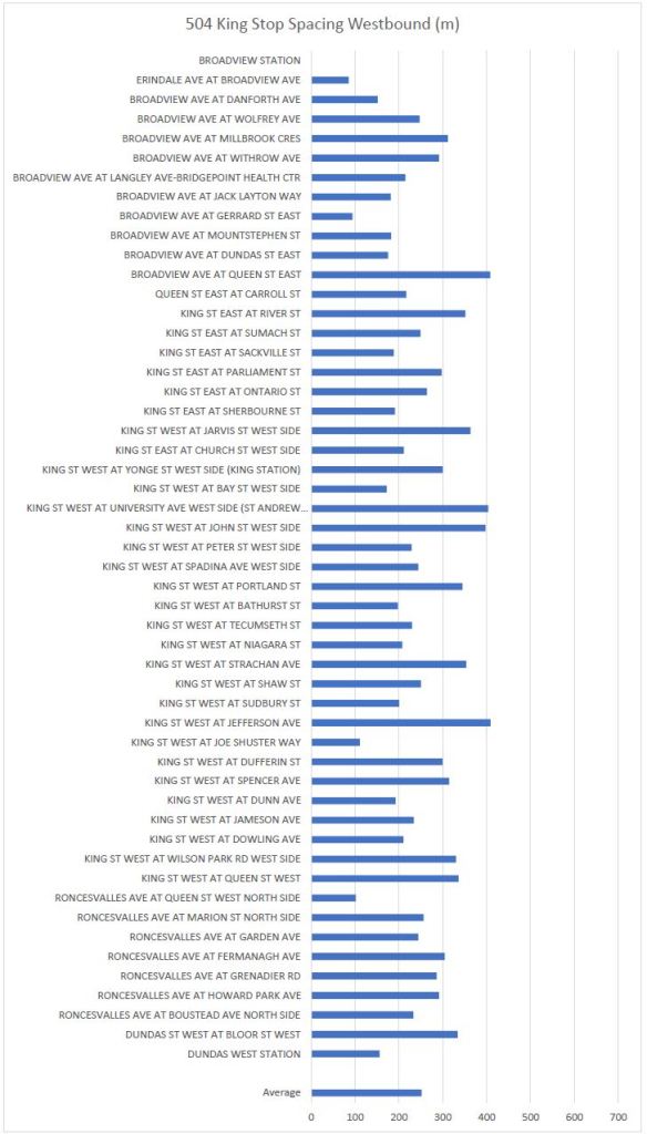
504 King
These charts show the “classic” King route from Broadview Station to Dundas West Station without the branches to Distillery and Dufferin Loops.
Note that over the years, this route lost several closely spaced stops thanks to both the King Street priority corridor scheme, and the Roncesvalles reconfiguration.
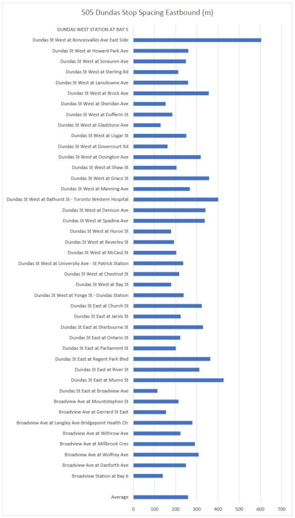
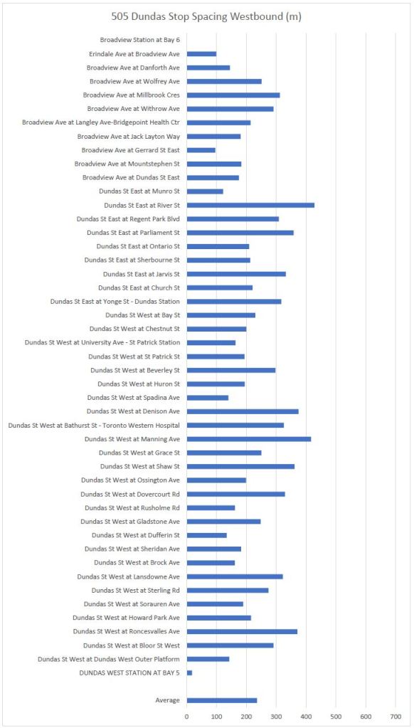
505 Dundas
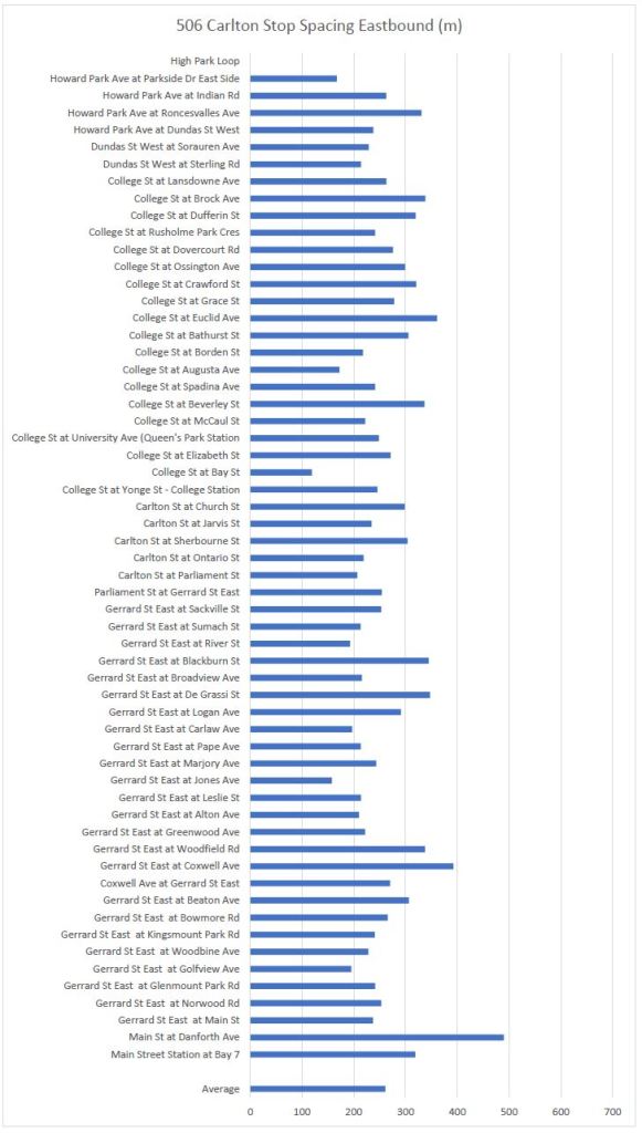
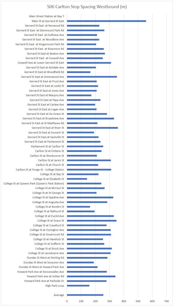
506 Carlton
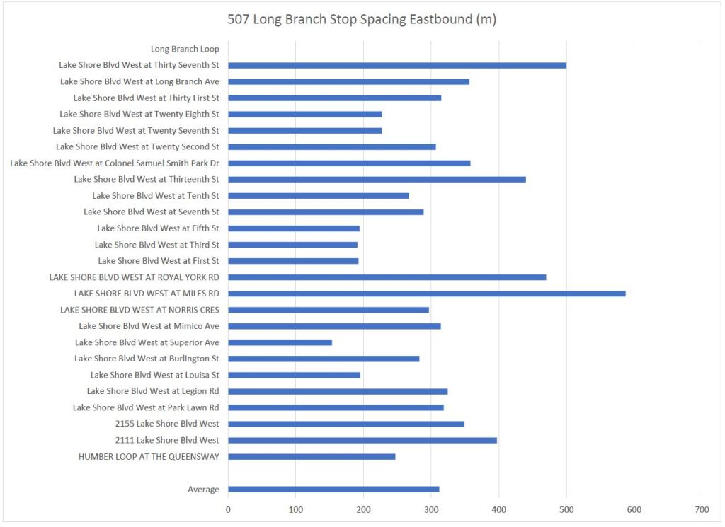
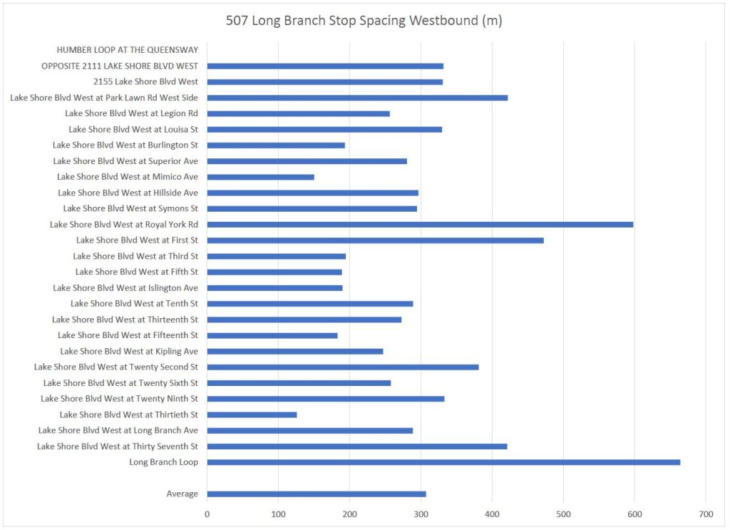
507 Long Branch
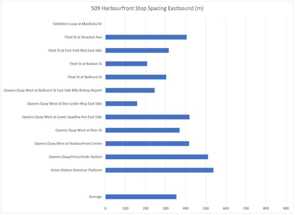
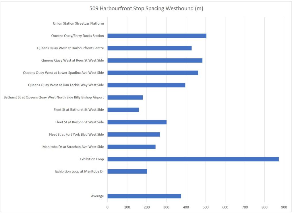
509 Harbourfront
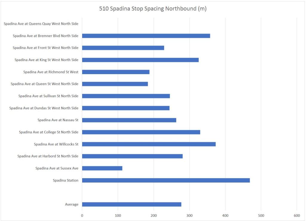
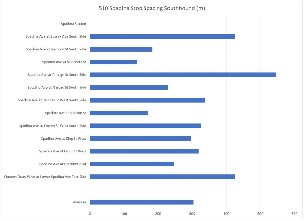
510 Spadina
These charts cover the portion of the route between Queens Quay and Spadina Station. The stops on Queens Quay itself are covered by the 509 Harbourfront charts above.
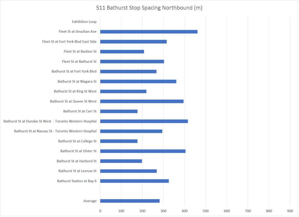
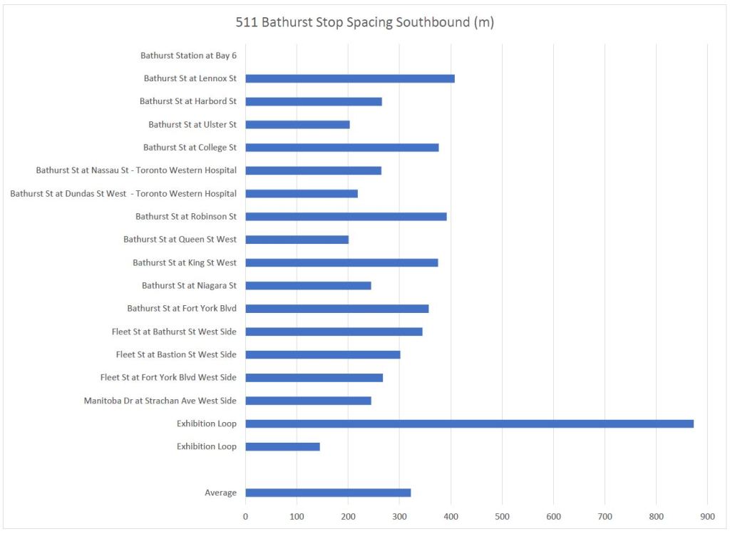
511 Bathurst
Note that two “Exhibition Loop” stops are shown. The first, with a long spacing, is the drop-off location. The second, nearby, is the pick-up location.
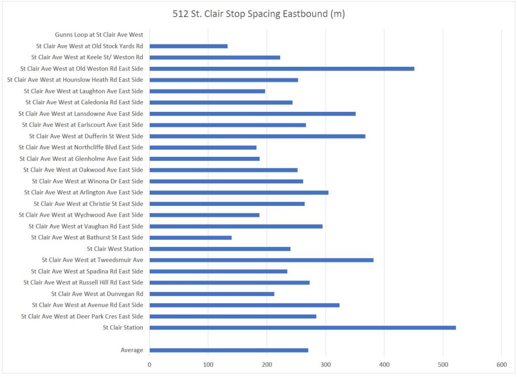
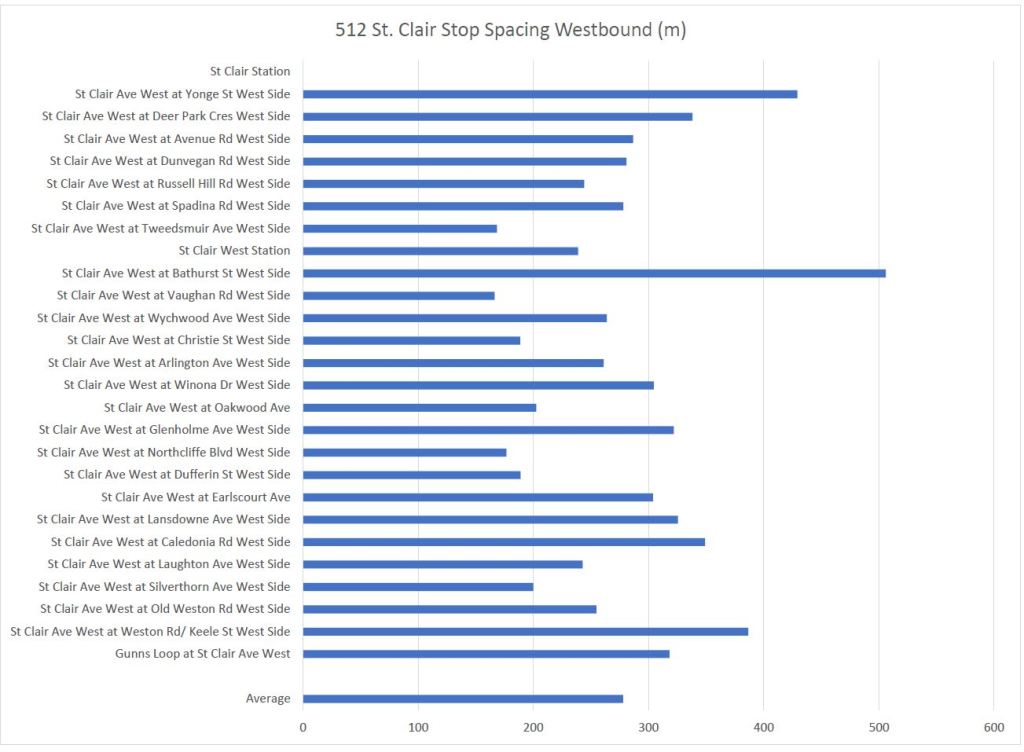
512 St. Clair
A Few Sample Bus Routes
Lest the situation on the streetcar routes be portrayed as symptomatic of “downtown” thinking, here are a few major bus routes for comparison.
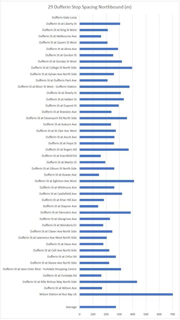
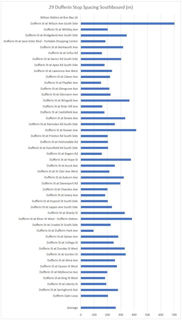
29 Dufferin
29 Dufferin has one long gap between stops immediately south of Wilson Station. Otherwise the distribution of stop distances looks similar to the streetcar lines above.
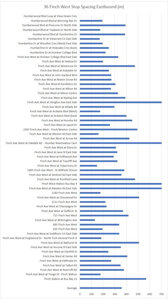
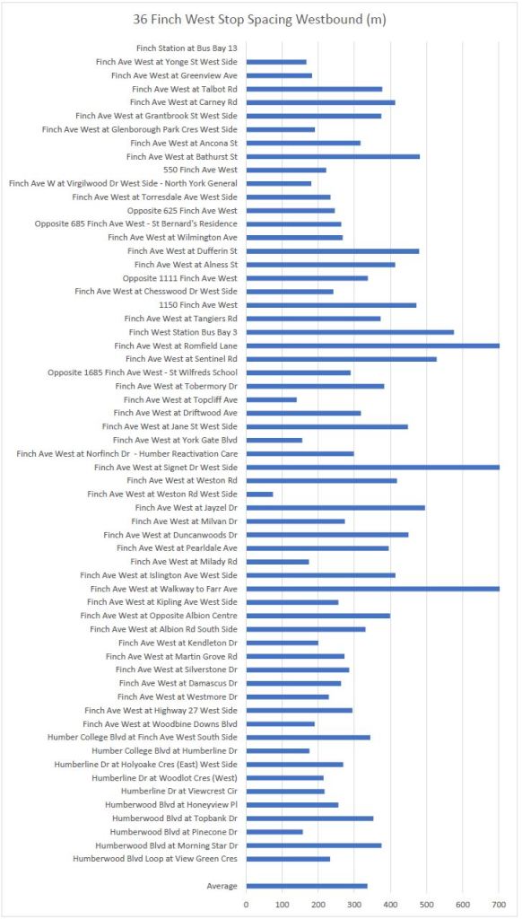
36 Finch West
36 Finch West has a few widely space stops where it intersects with major highways, and also for the excursion off of Finch to Finch West Station.
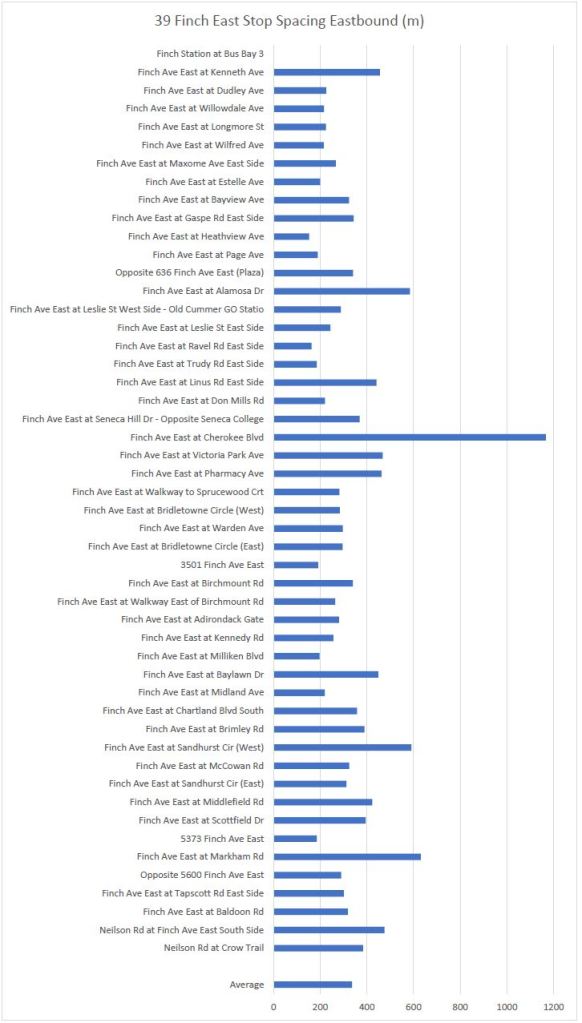
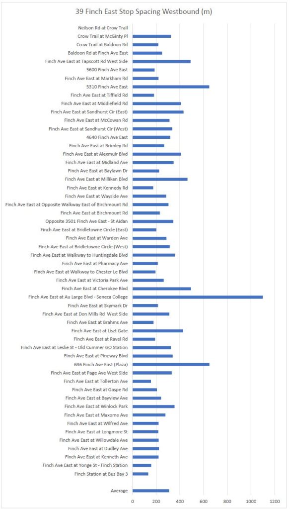
39 Finch East
The one long stop spacing on 39 Finch East corresponds to the DVP crossing.

Might be interesting to overlay additional metrics (if available) like time between stops and estimated number of passengers boarding and disembarking at each stop.
Steve: Time between stops is tricky because it can vary a lot. I have been after TTC loading data for years without success. It has been a state secret it seems, although is now part of their open data feed at least on a coarse level. For stop level counts, though, I need better than “empty-medium-full”.
LikeLike
I know who started that claim, and I keep wondering why people haven’t realized that person has awful takes, and is extremely biased against the streetcar network?
I deliberately did not name them as I wanted to speak to the issue, not the person. There is far too much ad hominem argument on X as it is in the “Steve said it and he’s crazy” type of in depth analysis.
LikeLike
I’m on the 512 line and note that the distances involving the two stations will skew the average, as they apparently include all the trackage in the loops. St. Clair station entrance to the Yonge St. stop westbound is less than 100 m (or about 250 m from the boarding location in the station if you walked). St. Clair West station entrance to the Bathurst stop westbound is less than 300 m. And from Tweedsmuir stop to the West station entrance is about 150 m. The charts show much longer distances for these intervals.
Steve: Yes, there are instances like that on several routes, but the question is about distances between points passengers can access vehicles. I decided not to tweak these numbers, and the charts overall show the pattern on stops along each route.
LikeLike
I think a more important comparison would be between Toronto and successful tram systems in Europe, as well as a study on how shorter stop spacings interact with a higher frequency of signalized intersections. I think it’s these two factors in combination that lead to many of the issues we experience with streetcar travel delays.
LikeLike
Signalled intersections WITHOUT streetcar stops should have true transit priority (not the current so called transit priority of 3 to 5 seconds of green if a streetcar approaches). The streetcars should be able to move from one streetcar stop to the next without having to wait for a red that has no streetcar stop.
Also means replacing crosswalks without a streetcar stop should be converted to a signalled crossing. Timed with the streetcars and the following or next traffic signal.
Egress points like Dundas West, Bathurst, Broadview, and Main Stations, should have a YIELD to STREETCAR sign, giving streetcars (or other street railway vehicles) the right-of-way at unsignalled intersections. (As per the Vienna Convention on Road Traffic, which is unratified by Queens Park.)
LikeLike
Very interesting data. The 507 to me is particularly interesting, because there are quite a few stops that vary in distance between Long Branch Loop and Islington Avenue.
I understand that the average of the entire route is slightly less than 400m, but achieving the goal is (like you mentioned) incredibly difficult due to the layout of Lake Shore.
Rather than eliminate stops, would it be possible to isolate streetcar traffic much like Spadina and St.Clair and replace a switch at Kipling Loop? I’m sure that would have significant impact on streetcar times than eliminating stops.
The problem on Lake Shore is that some portions of it are too narrow for a streetcar right-of-way plus traffic lanes as on St. Clair. This came up in the preliminary design work for a Waterfront West LRT. The problem section is the twisty portion through Mimico. There is still a plan to create a reserved lane as far as Park Lawn Loop, if it is ever built.
I’m not sure what you mean by “replace a switch at Kipling Loop”.
Thanks again, Steve. I hope you had a wonderful Civic Holiday.
LikeLike
Many, many years ago, I remember a column in a transit magazine that claimed that the average spacing of bus stops was not far enough for a bus to shift out of first gear. (May have been second).
Considering the speed I have ridden buses on, I find that hard to believe. One important point is that, especially off peak, not all stops require vehicles to stop because nobody is getting on or off. That said, larger cars and wider headways make it more likely that even minor stops will have demand for many trips.
LikeLike
The TTC’s Service Summaries include average speed of a route in their statistics. Comparison with bus routes the service similar “downtown” areas as streetcars, such as 65 PARLIAMENT or 94 WELLESLEY, show fairly similar speeds. Even routes like 29 DUFFERIN slow to streetcar-like speeds despite the stretches of “suburban” running.
Steve: An archive of service summaries is on this site.
Another factor in streetcar stop spacing is how far people have to walk to their destinations, especially if they are off the main street, like going to or from their residence.
For the LONG BRANCH route, west of Kipling, it can be 600 metres or more just to walk north from down by Lake Promenade, to Lake Shore Boulevard. Then having to walk several hundred metres either way to the nearest streetcar stop would require about ten minutes of walking.
For the KING route, you might think that the stops on Roncesvalles are too close together, but west of Roncesvalles the residential area stretches 600 metres to Parkside Drive, and I expect that most riders will chose to use the “frequent” KING car over the infrequent 80 QUEENSWAY bus for their trip. And it is about 400 metres from Roncesvalles to Sorauren, which might be the dividing line between KING and 47 LANSDOWNE.
How far people might be motivated to regularly walk to their nearest stop, there to wait for unpredictable service, is a good question. Long stop spacings will certainly discourage local short-haul transit usage, like hopping on the streetcar for four or five stops in bad weather. Should the TTC only cater to medium haul travellers (long-distance being of course GO Transit’s purview, in theory anyway)?
You can play with measurements on the City’s maps.
Click on the ruler icon and see what you can find.
Steve: You can also do measurements on Google Maps.
Years ago I rode streetcars in Riga, Latvia. The stop spacing there was indeed quite long. How much of that was still a leftover from Soviet days when it might be “Comrade, will will give you Lada in 10 years, now you walk or take streetcar, is up to you” is worth considering.
LikeLiked by 1 person
If “years ago” might be 1970s or earlier, the TTC’s buses in those days came with an Allison VH transmission which only had two gears, and it would not shift into second gear until around 40 km/h. So indeed it was possible for buses “not to shift out of first gear”, but that was meaningless because they might not do that on a busy downtown street evern.
LikeLiked by 1 person
It’s a scandal that every new traffic signal put in along a streetcar or bus route isn’t a transit priority signal. What does Transportation Services think their job is, and why isn’t it enabling efficient transit in Toronto? _Every_ nonmajor cross street signal should be a transit priority signal, but let’s at the very least start with the ones we’re putting in next month or next year.
There’s no way streetcars should _ever_ be waiting for a light at: Dowling Avenue, Close Avenue, Dunn Avenue, Spencer Avenue, Joe Shuster Way, Sudbury Street, Stanley Terrace, Niagara Street, Tecumseth Street, Portland Street, Brant Street, Peter Street, John Street, Simcoe Street (I think this one is one of two priority signals I actually know of in Toronto), York Street, George Street, Berkeley Street, River Street… and that’s just on King Street.
That would speed up the trips so much more than removing 20-30% of stops (because let’s be real, we wouldn’t end up removing more than that, since they actually serve destinations).
Steve: Believe it or not, the funding for TSP comes from the TTC’s budget, and there’s only so much to go around. It should be a basic item of intersection design, but it’s not. One pending improvement for streetcars is to use the GPS information from vehicles rather than loop detectors in pavement (which are expensive to install). This also allows for changes in detection points and redesign of rules for signal behaviour as a software change without tearing up the roadway.
LikeLiked by 1 person
Stopping every 300-400 metres is the sort of “efficiency” that people who habitually drive cars would love. You know, the same kind of people who think that buses and streetcars “cause” traffic, rather than all the single-occupant vehicles.
I used to live on a sidestreet off of St. Clair West. It was about 500 metres from my home to SCW and a streetcar stop wasn’t too far from where my street joined SCW. Now if it were shifted 200 metres away in the name of “efficiency”, I’d have had to walk 700 metres. That’s possible for an able-bodied person but not particularly convenient. And for a person with mobility issues, it’s quite a burden.
When I lived there, I was commuting to a job out on the Scarborough/Markham border, where bus stops were very spaced out. Getting off the bus and crossing the street, then walking to workplace across a sea of parking took a good 10 minutes. I don’t expect door-to-door service, but expecting passengers to begin and end each trip by hoofing 700-800 metres to get where they’re going seems unreasonable.
Could we tell this clown who thinks this is “efficient” stop spacing that if they don’t want to have to stop behind a bus or streetcar they should just not drive?
Steve: I believe that the person in question is a regular transit user. He does, however, have something of a fixation on how bad the streetcar system is.
LikeLike
The signals at King and Berkeley do actually hold a green if a streetcar or bus is approaching. A handful of other signals along the route appear to do the same but only during certain periods of the day.
Ideas like that are suggested by people who don’t use transit and don’t know what the situation is like on the ground. They are the kin of the people who come up with new TTC route alignments for diversions and such.
LikeLike
I agree that you probably can’t remove dozens of stops from each line, but isn’t it worth questioning if each line’s stops can be optimized to reduce trip times/increase speeds, and then do that work *in conjunction* with other projects to improve the streetcar experience — eg, signal priority, traffic violation cameras, improved frequency, fixing switches, reserved lanes (when possible), level boarding (where possible).
Why just accept the status quo? Is the current number of stops the ideal number? If so, why? Is every stop absolutely necessary?
Steve: I agree in principle. However, the premise at the outset was that streetcar lines are beset by very short stop spacings of about 100m and this simply is not true. Detailed stop-by-stop review has to look at cases where removing two moderately spaced stops would create a big gap, and possibly leave other sources of delay. The whole point is that it is a detailed review, not a blunderbuss stop elimination, that would be needed. Moreover, the idea that there are big improvements to be obtained only by stop elimination is foolhardy.
A related problem is that when TTC says it is “adjusting” service, this often means it will get worse. There is a credibility issue. Remember when the TTC first talked about reserved lanes and stop removals as a way to reduce the number of buses on a route rather than running more service. If the primary reason for making people walk further is to save money, not to increase service on the route, there is a big marketing problem.
LikeLike
I understand why automating signal prioritization is necessary and good, but it feels like streetcar drivers should also be able to hold, release or request early signals, since they can see whether someone is waiting at the stop and know whether there’s someone who wants to get off.
Steve: I agree. One option that has been considered is to tie the need for priority to whether the doors are open, as opposed to a separate signal an operator (bus or streetcar) would have to manage. Retrofitting anything to the fleet is not a small undertaking.
LikeLiked by 2 people
Oh, I got it with a bit of searching. It’s the Clown Prince of Crayoning himself. Guy wants to build subways everywhere. Never provides any real analysis and never looks at issues of finance. And on this topic shows he never looks at actual data. Toronto’s streetcars ARE not a grade-separated LRT or subway. Their historical role was serving as local surface transportation and they need local stop spacing. Sometimes that’s 300m between stops, sometimes it might be 120, depending on geography and use. Faulting a local transportation service for not being express is stupid. Could things be improved with dedicated ROWs and true TSP? Sure, and it should be done, but there’s no free lunch. If Toronto wants rapid transit lines, it has to build them and pay for them.
LikeLike
They should do something about those slow zones. I recently noticed there’s now a slow zone at the east end of the Don bridge at Queen. I wonder if it might be the same problem that caused the previous shutdown.
LikeLike
Thanks Steve!
L. Wall wrote:
Really? That is one of my regular stops. King street changes direction, by about 15 degrees at Berkeley. I can look east, on King Street, and see if a streetcar is approaching. The actual stop is not at Berkeley, which is only about 50 meters west of Parliament – it is about 100 meters west, at Ontario Street.
I am an old man, so I no longer run to try to make sure I catch a bus or streetcar. But, unless the streetcar is close to Parliament, I can generally get to the streetcar stop with plenty of time.
“Holding a green light” – that is not the same as guaranteeing green lights all the way, correct? That is what I would like to see.
Steve: Yes, at many locations the green time will be extended for an approaching streetcar. This works best at locations with farside stops, lightly used nearside stops, or no stop at all. For busier stops, there is a good chance the streetcar will have to stop and won’t be able to make use of the extension. Another problem that came out at a TTC meeting this week was that, at least on St. Clair, most of the TSP detection was not working, but was repaired during the recent shutdown for other work. I will get into this in a bit more detail in an article about the meeting later today (Sept 13).
Ten or fifteen years ago there were a few TTC bus shelters that had a display that offered a prediction for riders as to how long until the next streetcar would arrive. After ten or fifteen years, shouldn’t that technology be (1) cheaper; (2) more reliable; (3) more compact? How long until it can be mounted on every stop?
Steve: The “Next Vehicle Arrival System” has always suffered from a lack of maintenance as if it were a nice idea that was forgotten after the capital budget to implement it was used up. There are screens in every subway station, but the screens in transit shelters are rare and often do not work or do not display all routes serving the stop. One problem at TTC is the attitude that everyone has a smart phone and can just call up Transit App (or whatever) to get the info. This excludes many riders.
LikeLike
WRT to predicting when the next vehicle will be, I’ll share an anecdote I don’t think I have shared before.
Older riders will remember a time when every TTC stop had a phone number, back in the days when few people had a cell phone, and there was no texting. Riders would phone their local bus-stop’s number before they left home. The TTC retired this system in 1999, with the laughable claim it would be too expensive to make it Y2K compatible.
Well the much smaller Kitchener-Waterloo Transit used the same or similar system. And, when I lived a block or so away from route 7, probably the system’s busiest route, I used to regularly phone the number, just prior to leaving home.
Route 7 was then served by 10 buses per hour. 80 percent of the buses turned at University Avenue, traveling to the University of Waterloo, and looping there. The other 20 percent of the buses went straight, and looped at Conestogo Mall, a fairly big mall.
One snowy day I phoned the local number before I left home, and had temporarily memorized the predicted arrival times — times not made more accurate by real-time tracking of the buses GPS location.
Another rider was at my stop. When he got on the bus, and asked the driver if the bus went to the big mall, I was surprised when the driver told him a different predicted wait time than what the computer voice had told me on the automated number.
So, I asked the driver about the discrepancy. He said, paraphrasing from memory… “Oh, that garbage thing? Sheesh, we never pay attention to its garbage schedule. All us drivers base our departures on the PRINTED schedule.”
The system had been in use for YEARS at this point. The drivers didn’t want to use it, and no one could make them.
LikeLike