
For many, many years, there has been talk of expansion of the streetcar system into the eastern waterfront. The “Waterfront East LRT” would branch off of the Bay Street tunnel at Queens Quay and running east initially to Villiers Island and eventually link with a southern extension of Broadview via the new GO/Ontario Line station at East Harbour.
Anyone waiting for this service will age considerably before it opens at the now tentative date of 2036. This was supposed to be a “Transit First” neighbourhood, but the history mocks all the fine talk of “Transit Oriented Communities” we hear today. Meanwhile, any attempt to actually use transit to reach this area is, putting it mildly, challenging. A collection of overlapping bus routes with infrequent and irregular service fight their way through chronic traffic congestion.
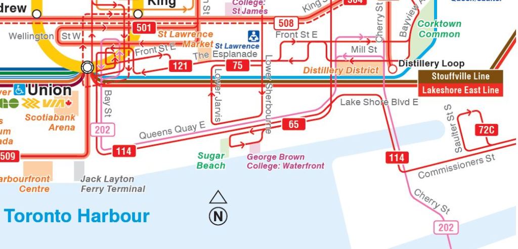
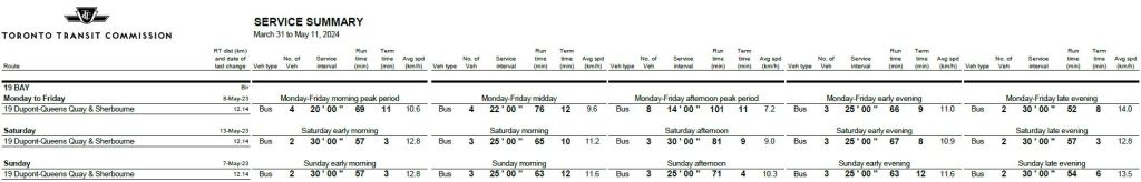
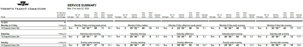
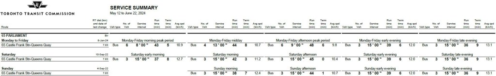
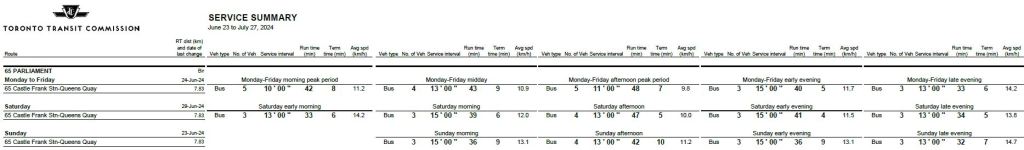
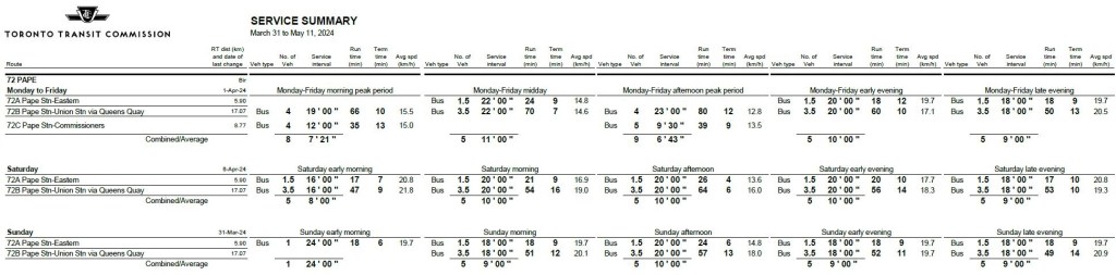
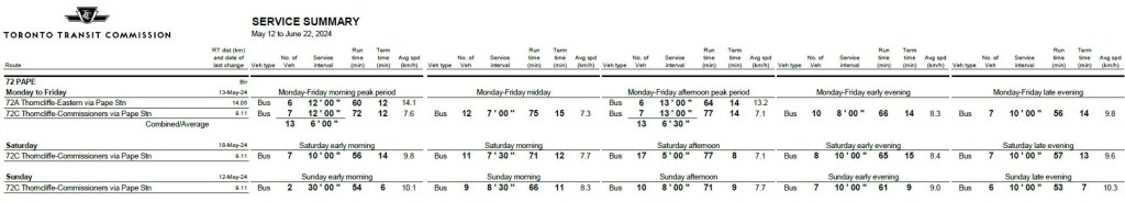
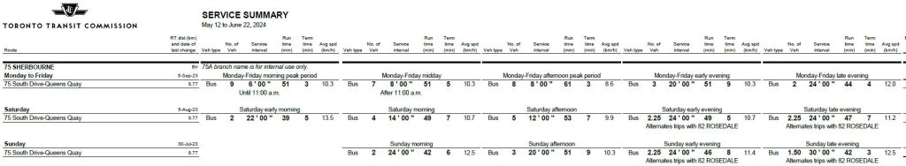
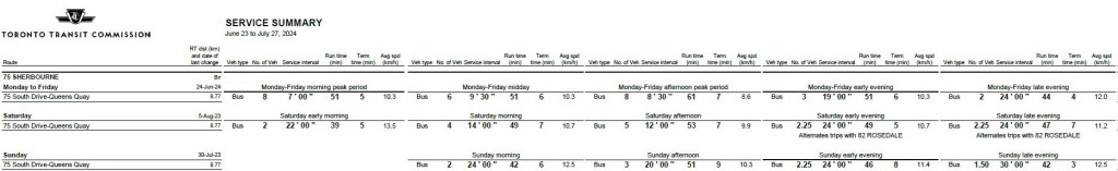
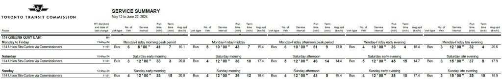
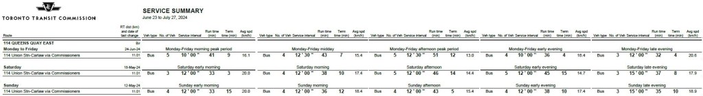
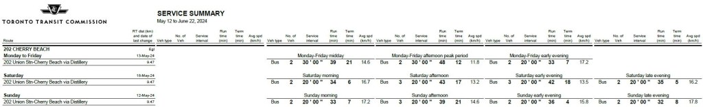
The route structure changed on May 12, 2024 as shown in the TTC maps below from 2023 and June 2024.
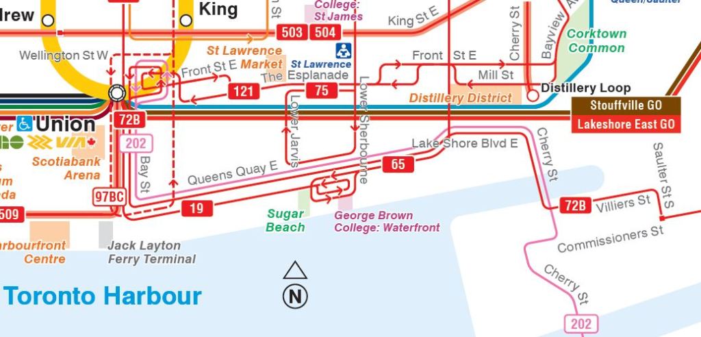
- 19 Bay
- 2023: From the central business district south on Bay and east on Queens Quay to loop at George Brown College near Sherbourne Street.
- May 2024: Route shortened to loop via east on King, south on Yonge, west on Front and north on Bay.
- 72 Pape
- 2023:
- 72A service from Pape Station to Eastern.
- 72B service to Union Station from Pape via Commissioners, Cherry, Lake Shore, Queens Quay and Bay. The route changed from time to time as the area was rebuilt to create Villiers Island.
- 72C service from Pape Station to Commissioners Street peak periods only.
- May 2024:
- 72A service to Eastern peak periods only.
- 72B replaced by 114 Queens Quay East.
- 72C extended west from Pape to Saulter Street and operated as the all day route.
- 2023:
- 114 Queens Quay East
- May 2024: New route from Union Station to Carlaw replacing the south end of 19 Bay and the west end of 72 Pape.
Two routes were not changed:
- 65 Parliament:
- From Castle Frank Station south via Parliament and west on Queens Quay to George Brown College.
- 75 Sherbourne:
- From Sherbourne Station south via Sherbourne and west on Queens Quay to Jarvis returning north via Jarvis and The Esplanade.
There is also the seasonal 202 Cherry from Union Station to Cherry Beach. Like the 72 Pape bus, its route has changed from time to time due to construction in the Villiers Island area.
Service Levels
Of the routes serving the eastern waterfront, the best scheduled service is on routes that do not connect to the core area: 75 Sherbourne and 65 Parliament. Service on these routes is driven by demand to George Brown College.
The 114 Queens Quay East bus runs considerably more often than 19 Bay, although it too is affected by demand to GBC. In theory, the combination of the south end of 19 Bay with the west end of 72 Pape allows the buses to be scheduled on a regular headway rather than whatever pattern the two separate schedules would provide. These two routes were notoriously unreliable operating separately. However, the combined service has many problems.
19 Bay is a shadow of a route that was once so frequent that Bay Street has a diamond priority lane, although this is observed by absolutely nobody. It is hard to believe that the headway south from Bloor Street was once 1’40” in the AM peak (36 buses/hour). It is now less than 10% of the level three decades ago.
19 Bay
65 Parliament
72 Pape
75 Sherbourne
114 Queens Quay East
202 Cherry Beach
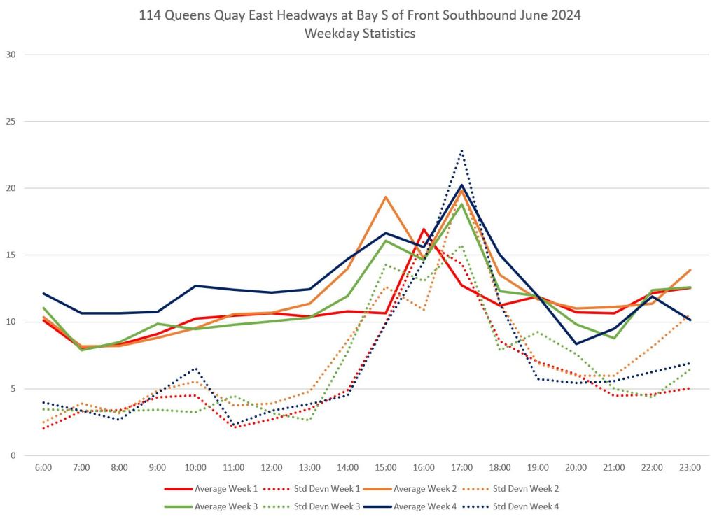
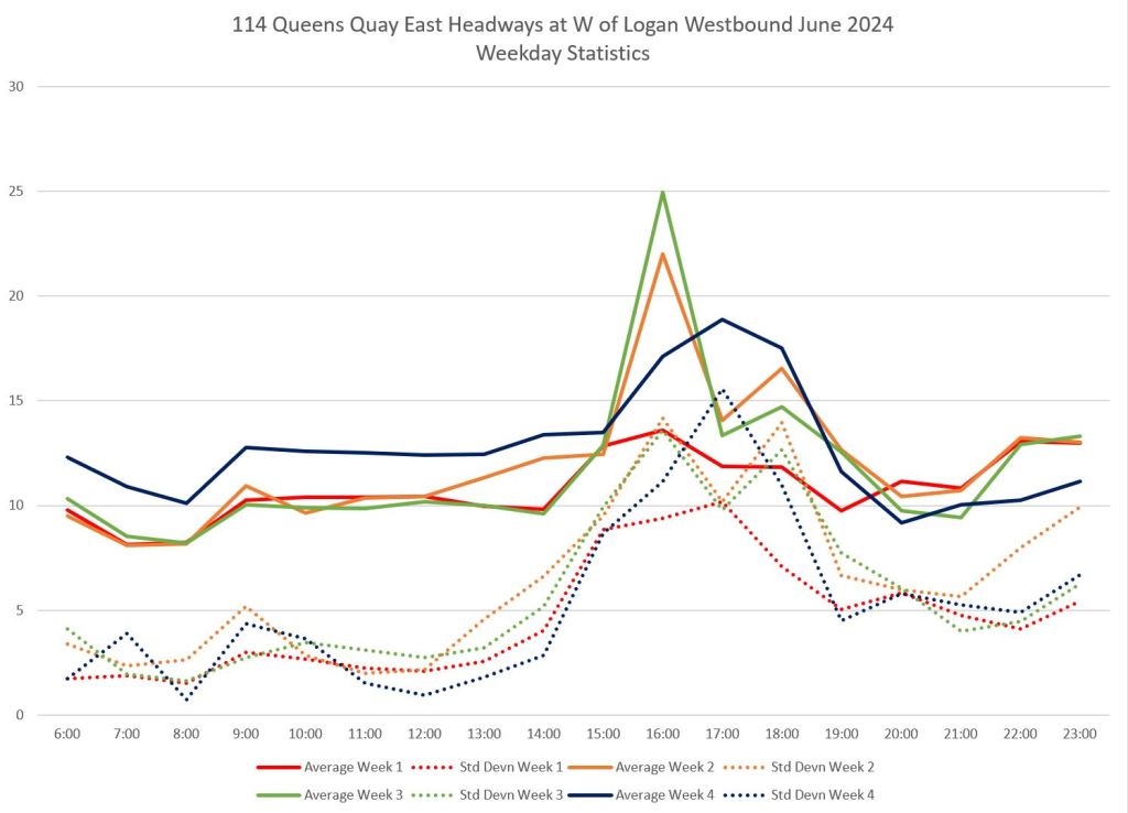
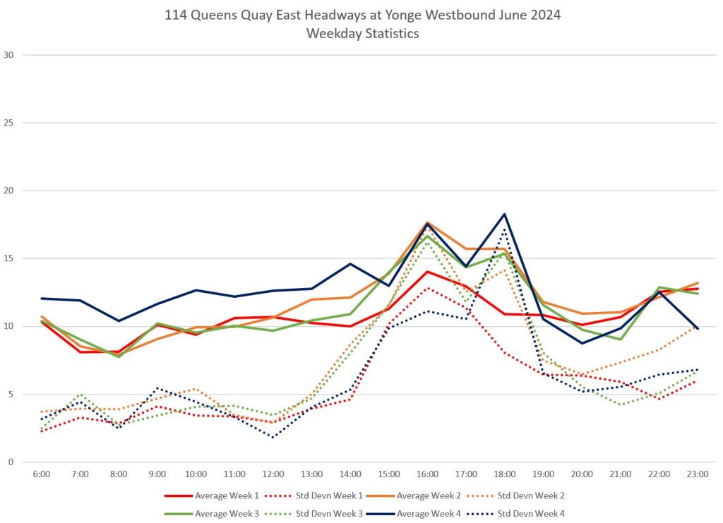
Service Quality on 114 Queens Quay East
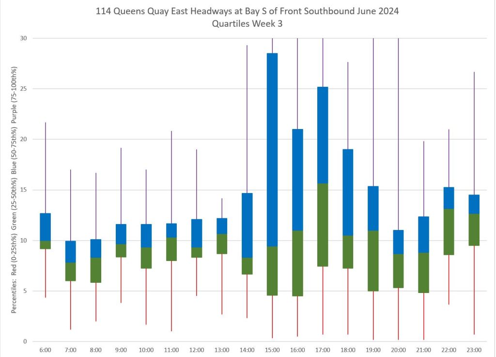
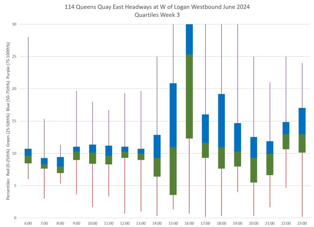
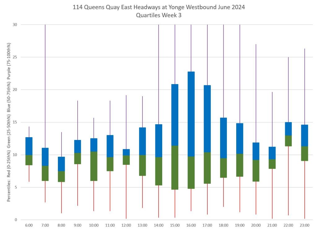
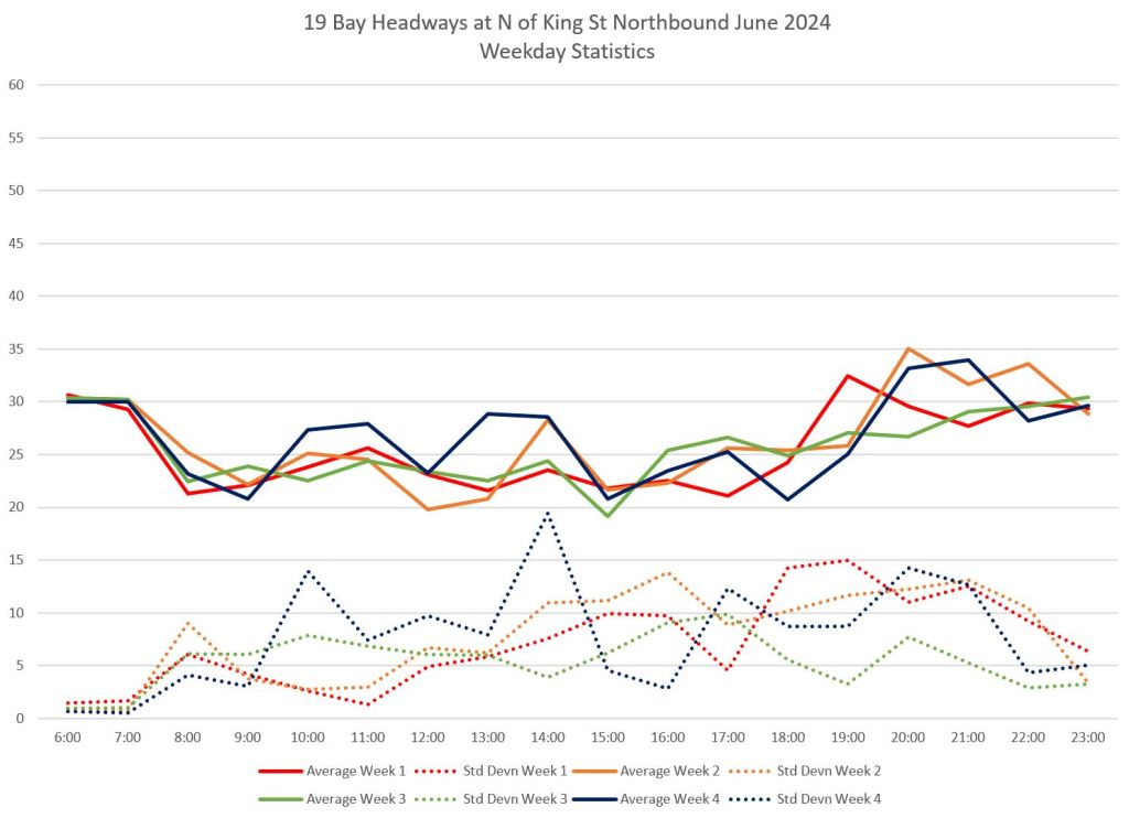
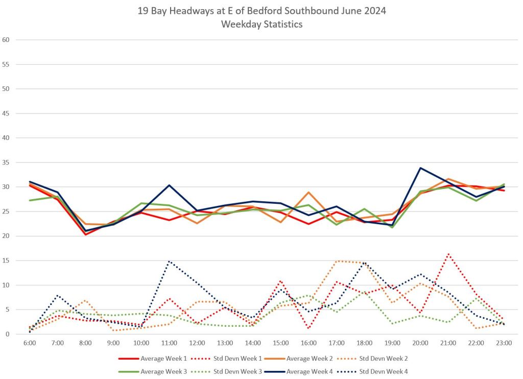
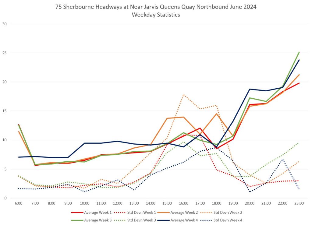
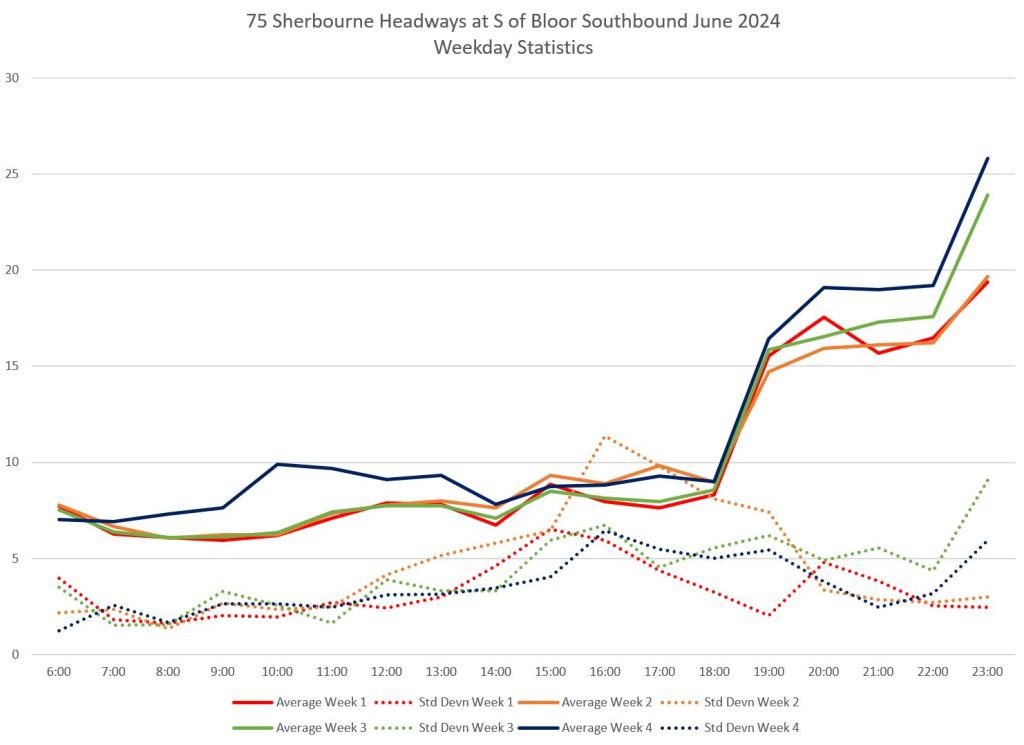
Service reliability is poor on weekdays particularly in the afternoon and PM peak when congestion makes impossible for buses to keep to schedule. Here are the weekday statics for headways southbound from Bay and Front, westbound from Logan and Commissioners, and westbound at Queens Quay and Yonge.
- The dark blue line (Week 4) is higher than the others because of the seasonal service reduction effective June 24.
- The average headways (solid lines) lie generally at the scheduled values except during the PM peak. This indicates that trips were lost in that period as buses could not complete their assigned runs.
- Standard deviations (dotted lines) are very high in the PM peak indication that much of the service is bunched with a wide range of narrow and wide headways.
- Even outside of the peak, the SD values show that headways, particularly in the evening, commonly range from 4-6 minutes either side of the scheduled values.
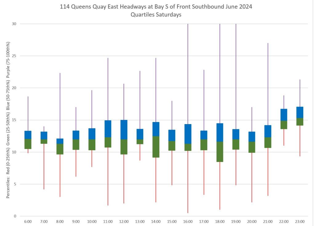
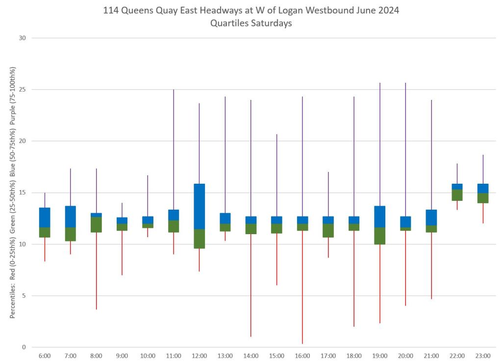
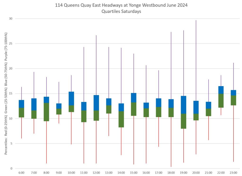
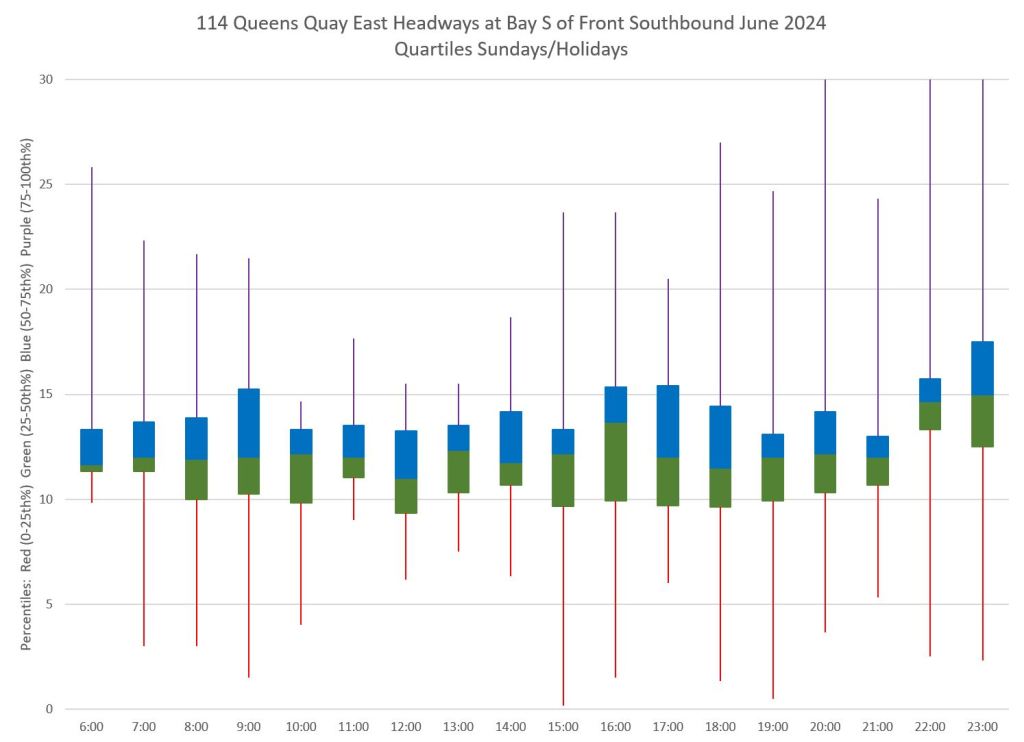
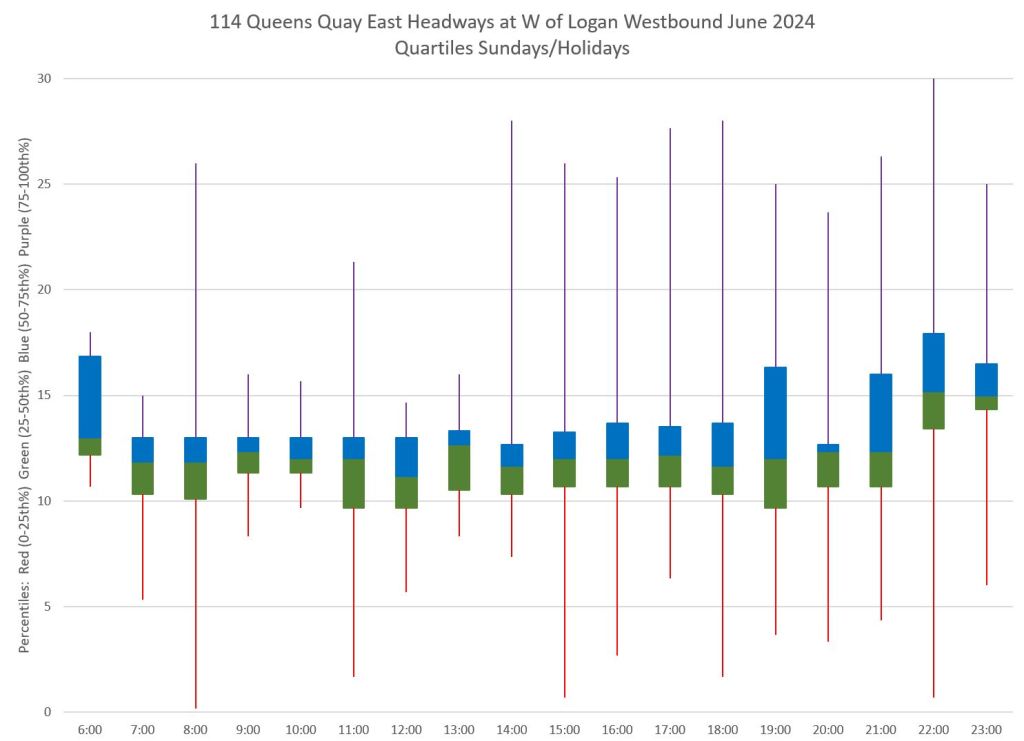
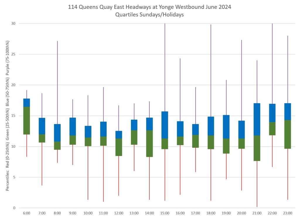
Although averages and standard deviations can show the general character of the data, the range of values can be seen in quartile charts. The blue and green boxes hold 50% of the data points with the median value at the boundary between colours. The purple and red tails hold the upper and lower quartiles respectively.
The top row shows the data for Week 3 for the same locations at the statistics above. The middle and bottom rows show Saturday and Sunday data for comparison.
- Values that run off the chart (over 30 minutes) are common on weekday afternoons, PM peak and early evening, as are values close to zero which come from bunching.
- Weekend values are more tightly clustered for the second and third quartiles (25th to 75th percentile), but the outlying values still reach well outside of reliability from a rider’s point of view.
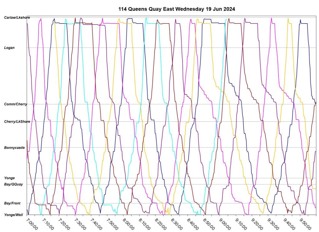
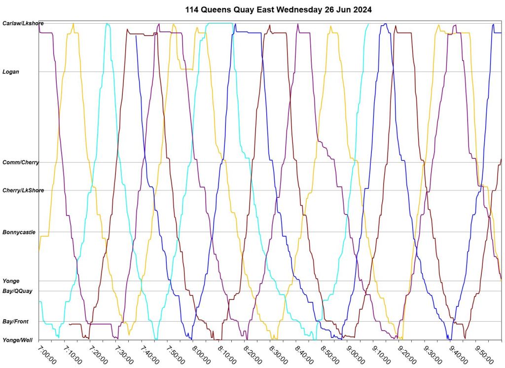
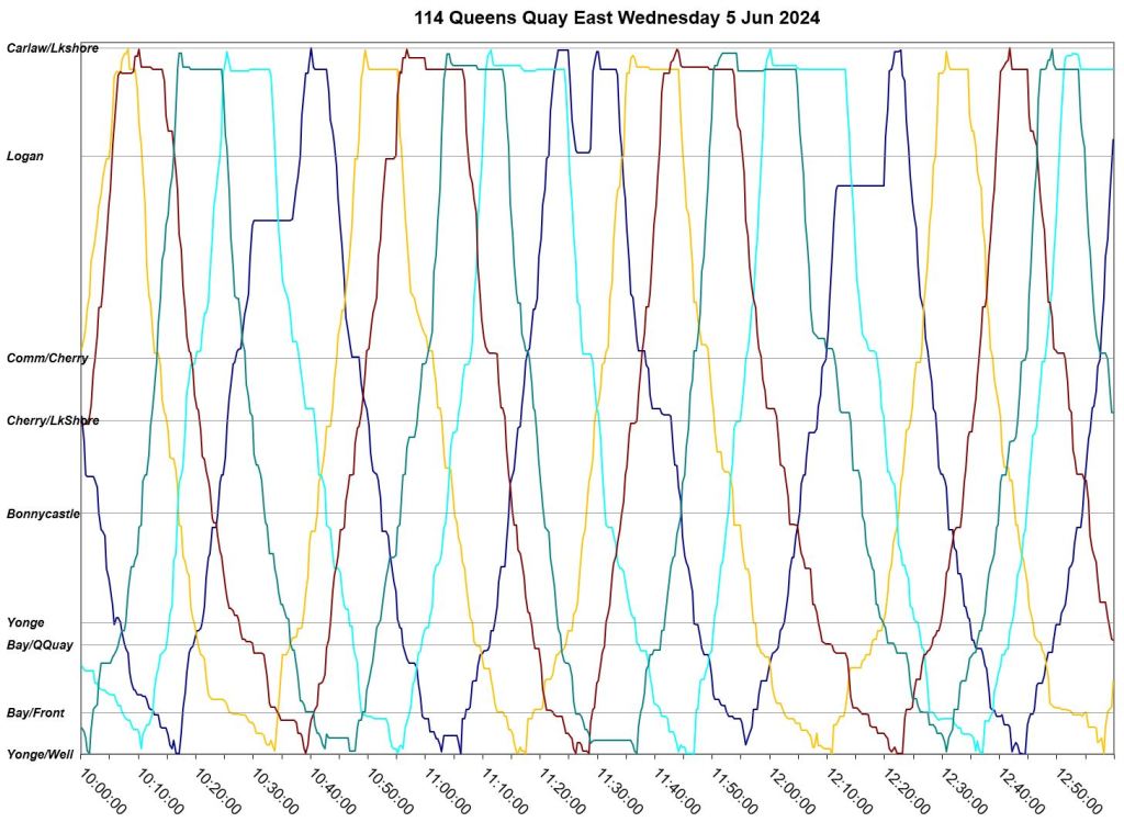
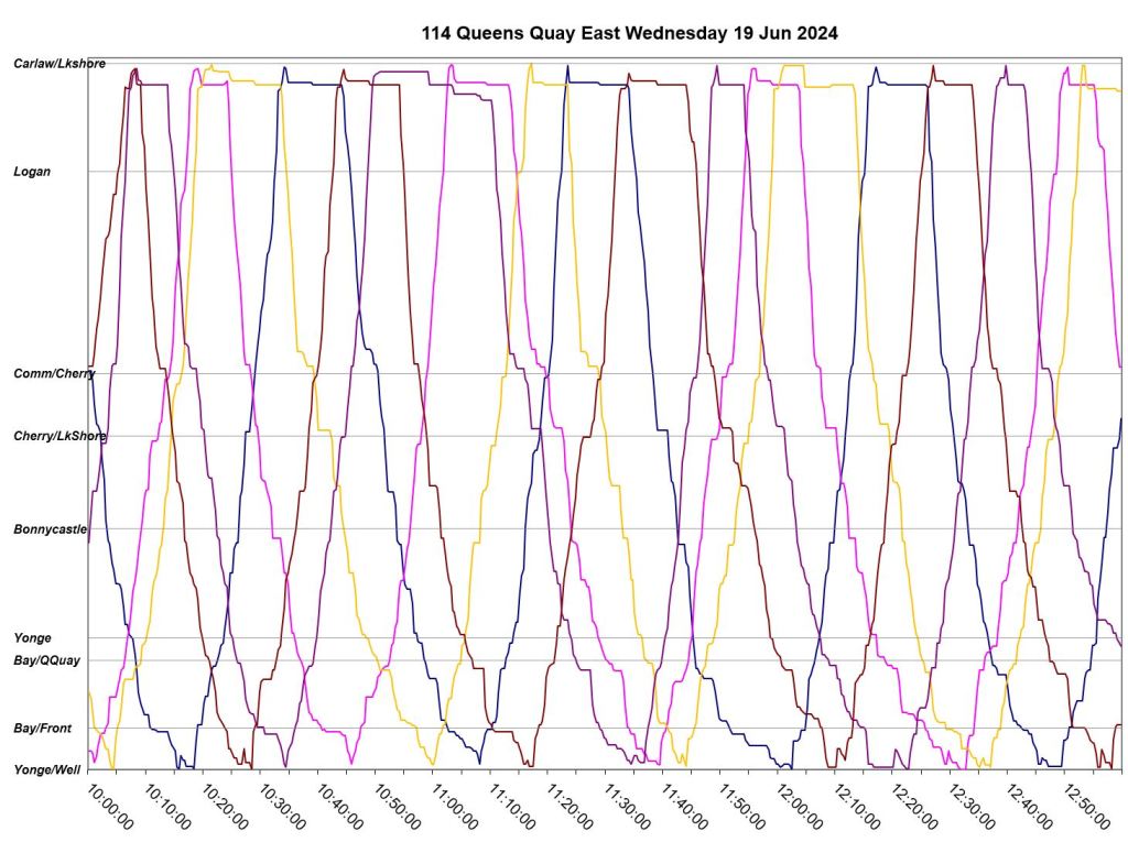
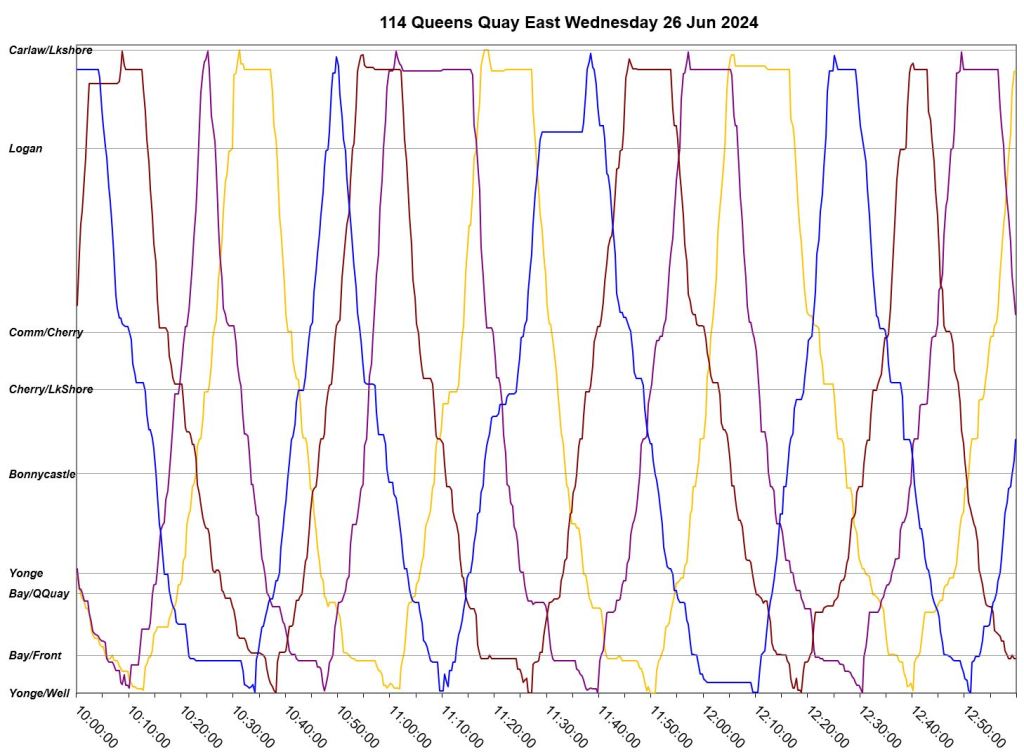
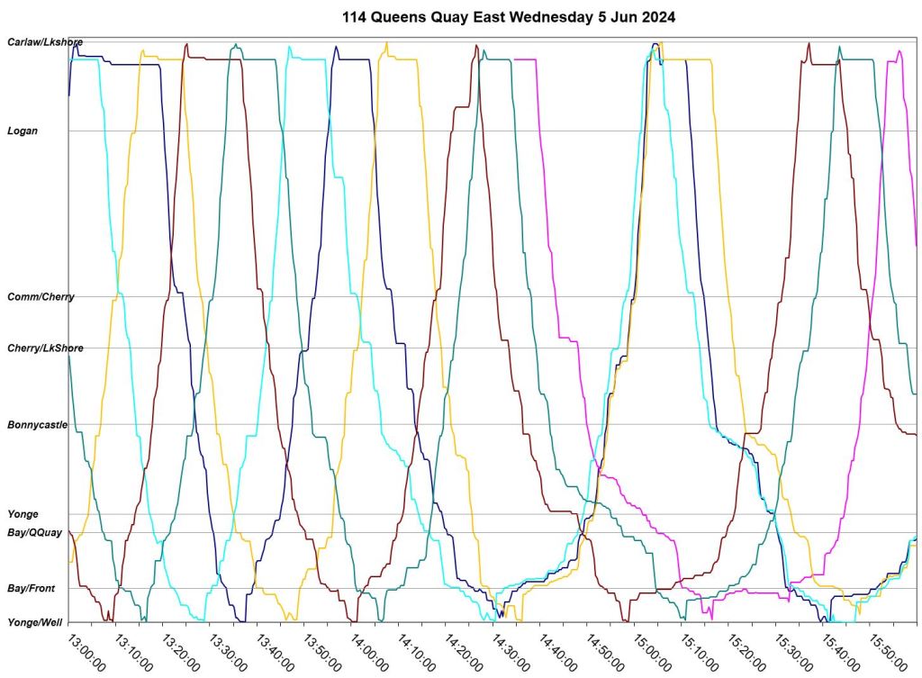
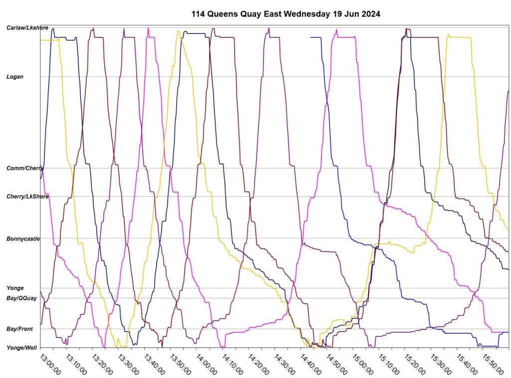
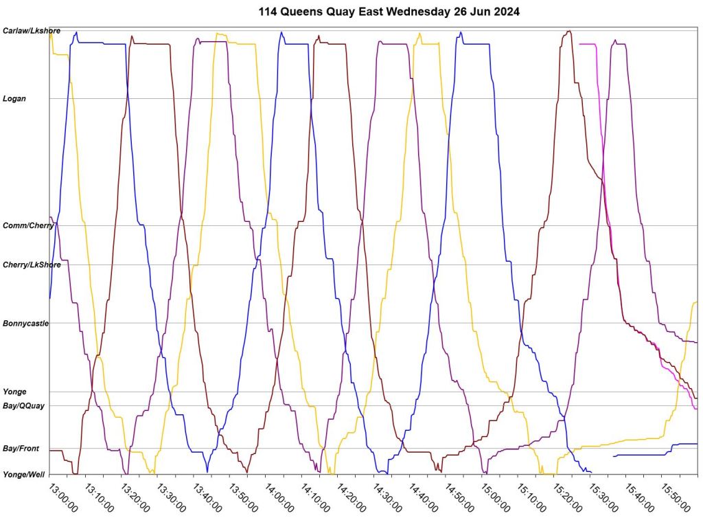
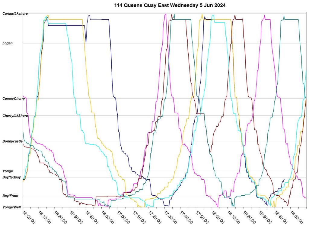
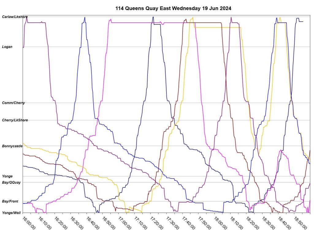
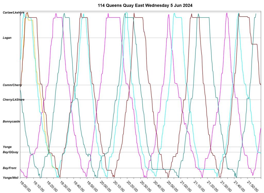
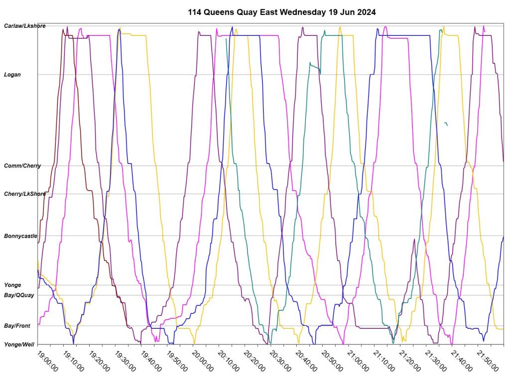
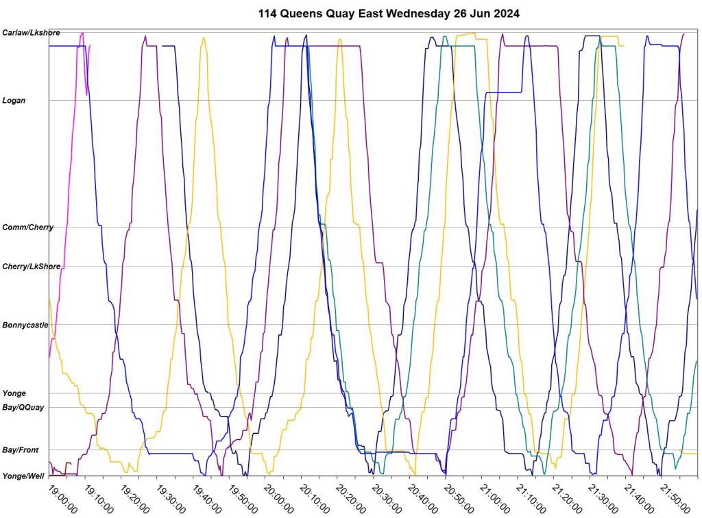
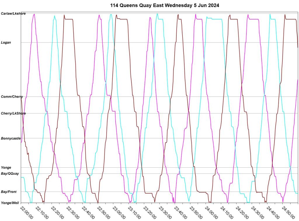
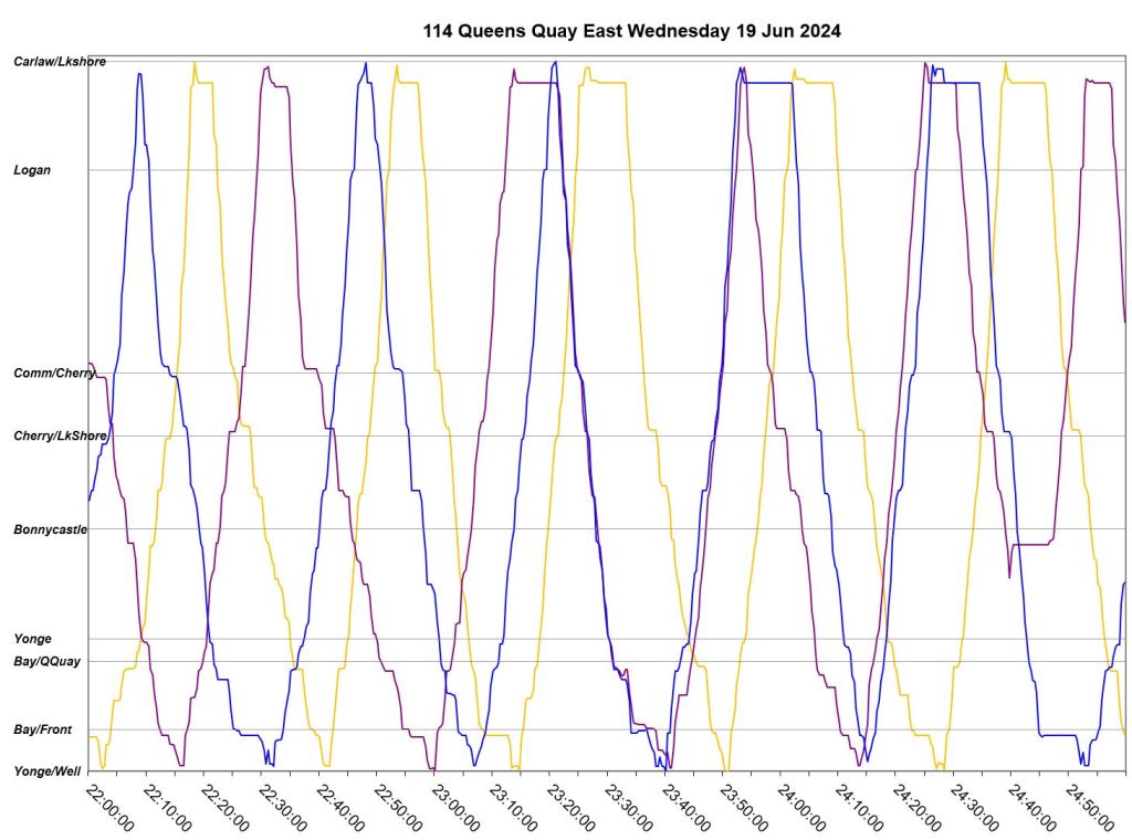
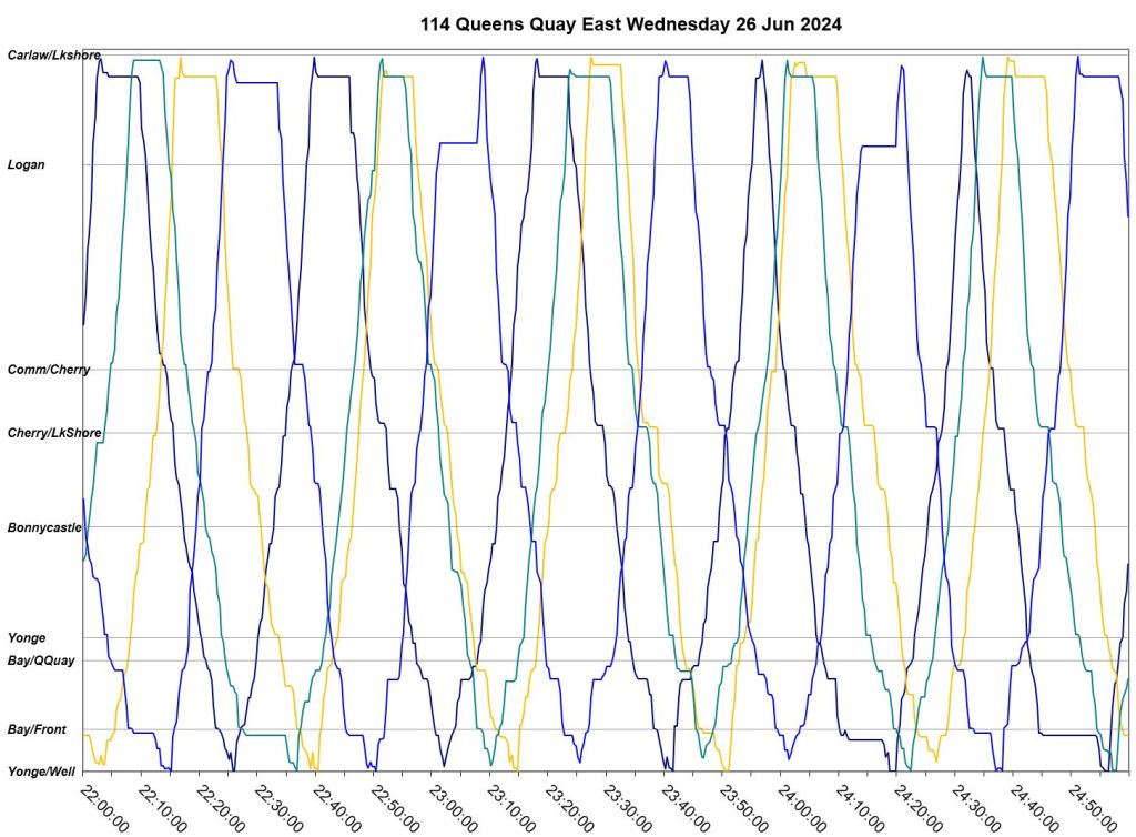
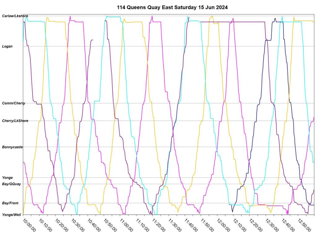
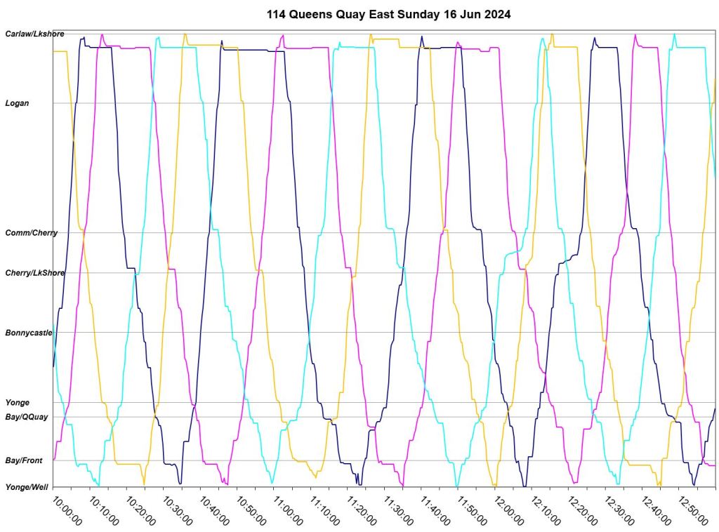
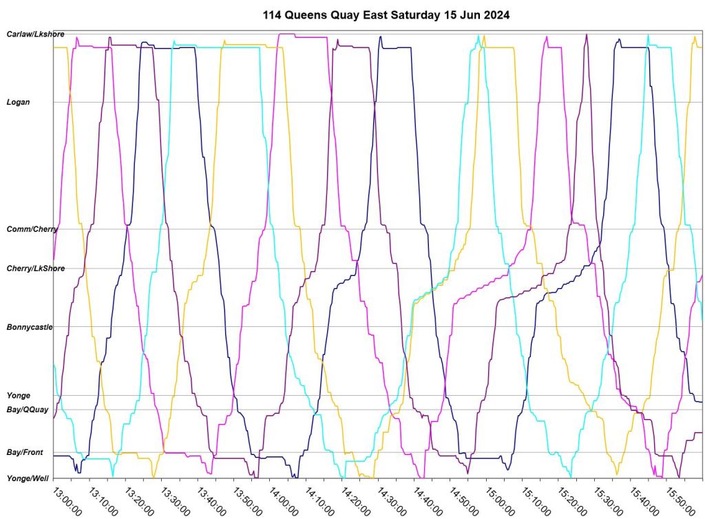
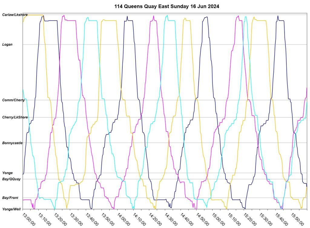
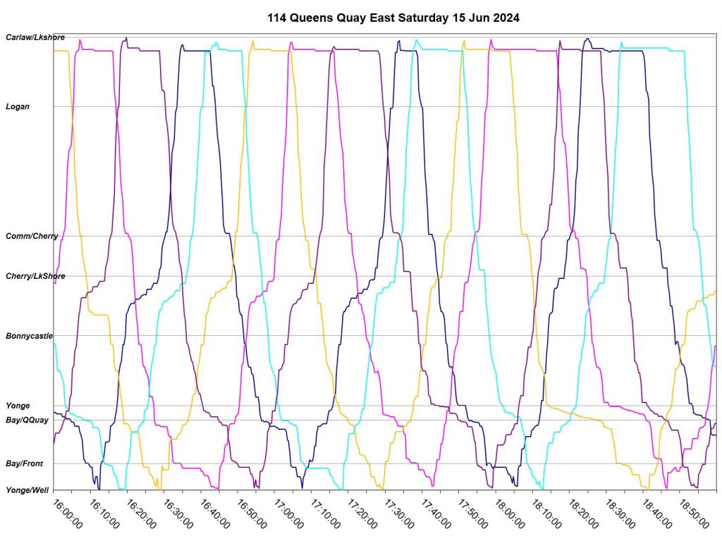
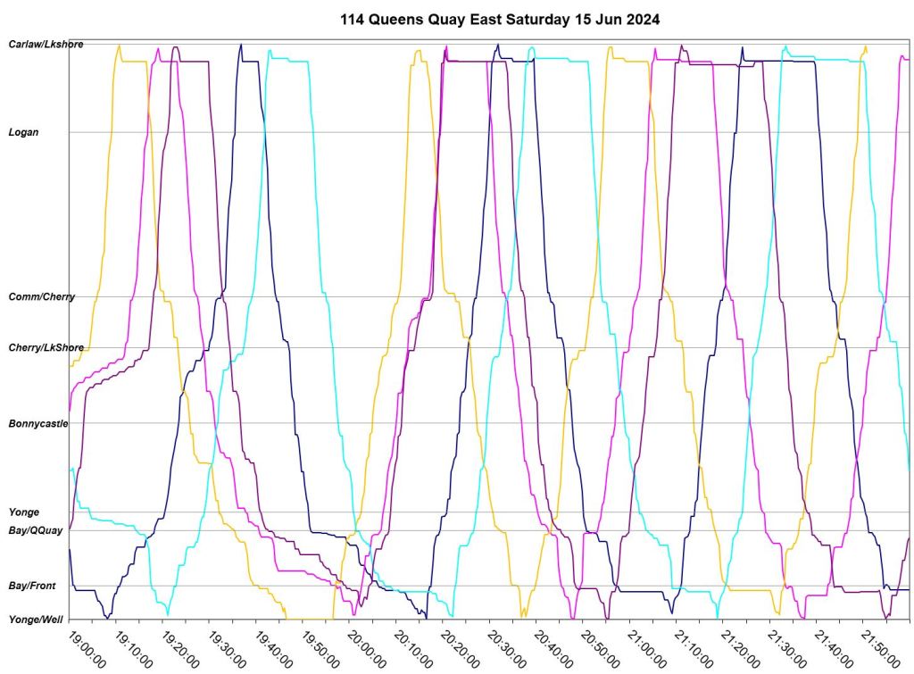
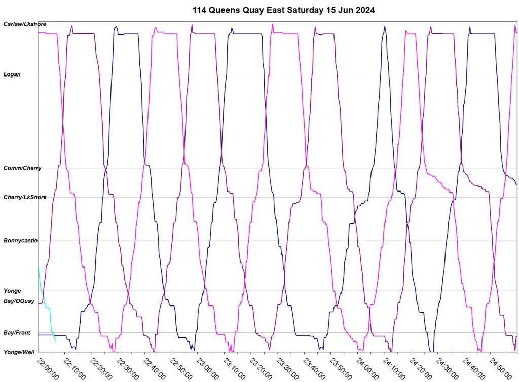
The charts below show the operation of buses on 114 Queen Quay East for three Wednesdays: June 5, 19 and 26. They are arranged with the same time period for each day in rows, and all data for individual days in columns. This shows both the similarity, or not, between comparable days as well as the evolution of the route from 7am to 1am.
In these charts, the east end of the route is at the top (Carlaw) and the west end is at the bottom (Yonge & Wellington). Westbound trips read down, eastbound trips up.
Items of note:
- Even when congestion (visible from lines that become more horizontal than vertical) is not a problem, particularly in the evening, bunching of buses and erratic headways are common.
- Layovers are generally taken at the east end of the route, and outside of the PM peak period, buses appear to have enough time for a short break on each trip.
- The afternoon peak sees severe congestion westbound on Queens Quay and northbound on Bay, westbound on Wellington from Yonge to Bay, and on Bay southbound to Queens Quay.
- Very wide gaps are common in the afternoon and PM peak periods.
- Short turns are quite rare.

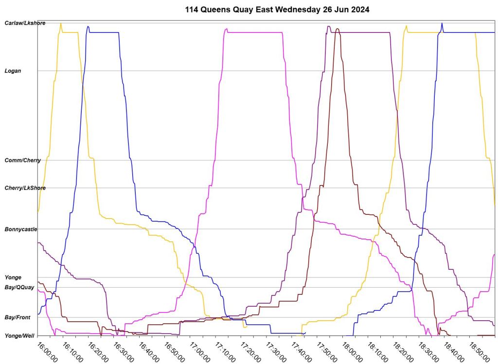
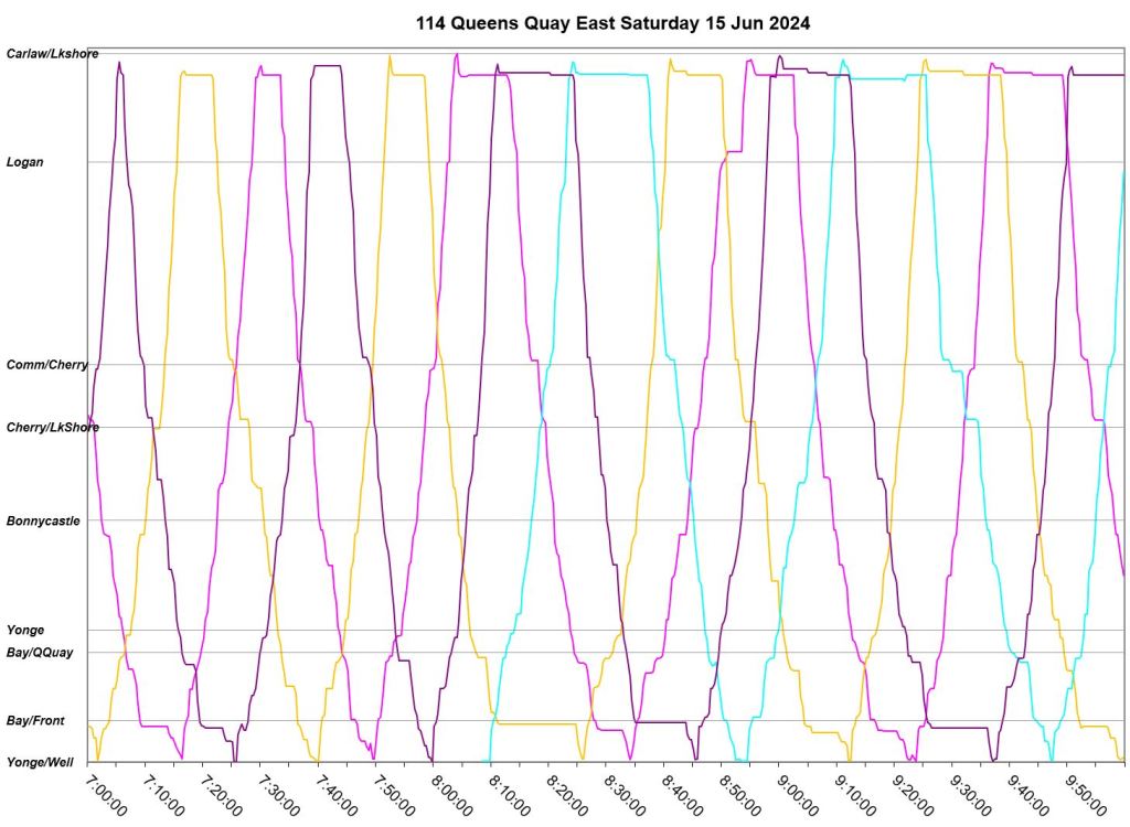
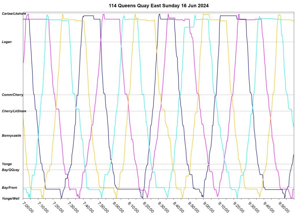
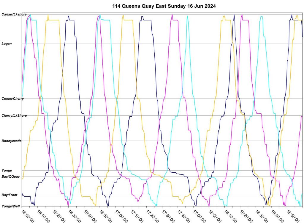
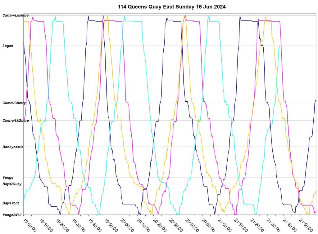
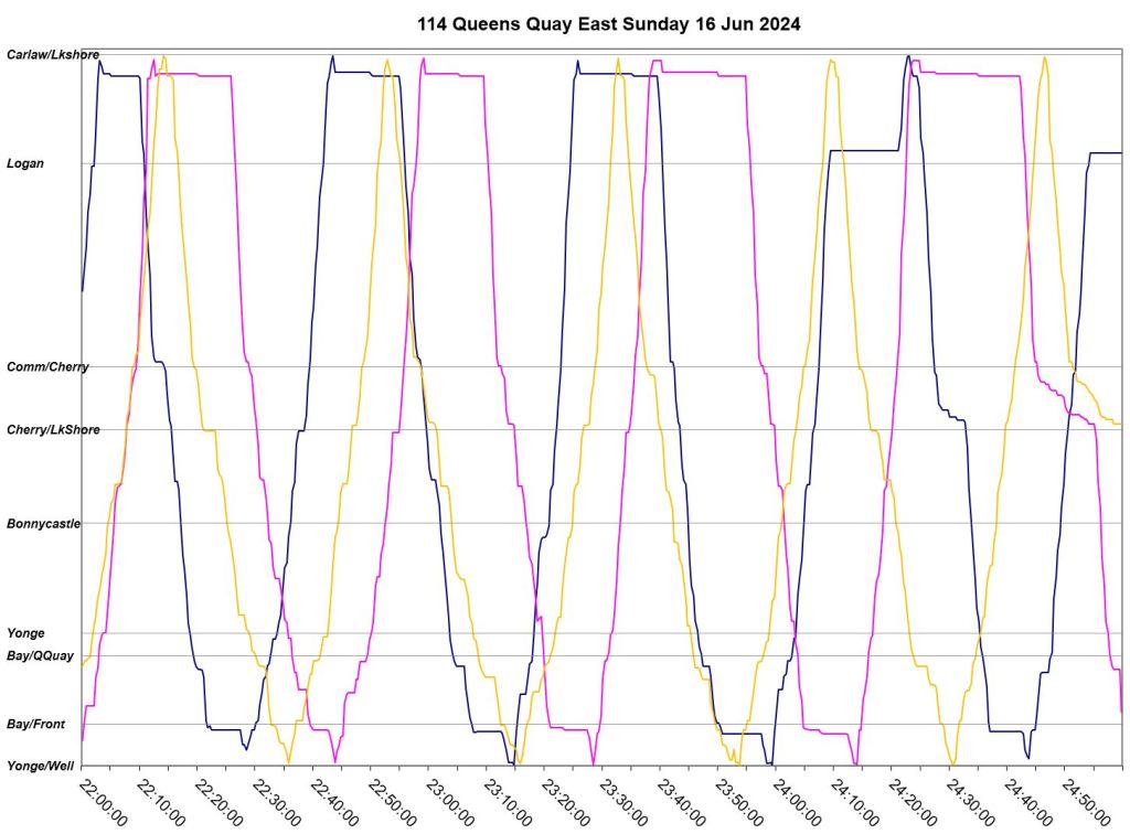
For comparison here are the charts for Saturday and Sunday, June 15 & 16.
- Congestion does occur on weekends, although not to the same extent and at different times than on weekdays.
- Bunching is less common than on weekdays, but still more prevalent in the evenings.
- Most trips have time for a layover at Carlaw, except when congestion extends travel times.
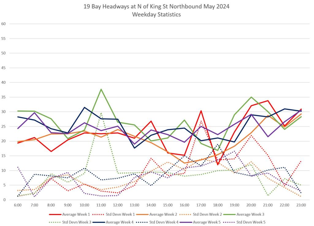
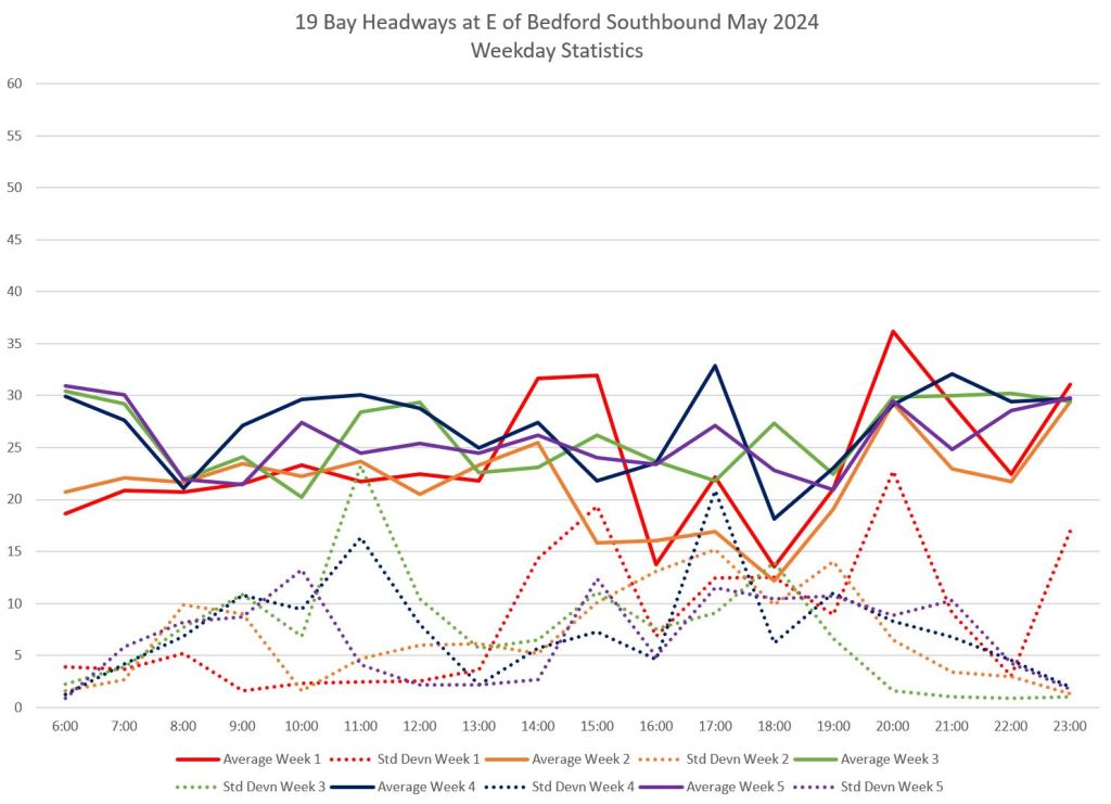
Service on 19 Bay
The charts below show averages and standard deviations of headways on 19 Bay northbound from King Street and southbound from Davenport east of Bedford. There is a clear difference between the SD values for the period before and after route was shortened in Week 4 of May, although the SD values are still high. This shows that the already wide scheduled headways on 19 Bay are even more exaggerated by buses running well off their scheduled headways even without the effects of congestion south of Front Street.
Service, if we can call it that, will be used only by those who happen to catch a passing bus, or by those for whom using the subway is not an option. Personally, this used to be my standard route between Bay Station and City Hall, but I can no longer depend on the Bay bus. This is a classic example of the vicious circle of service cuts and ridership loss, compounded by the changing travel patterns post-pandemic.
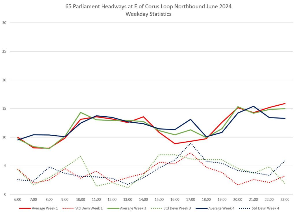
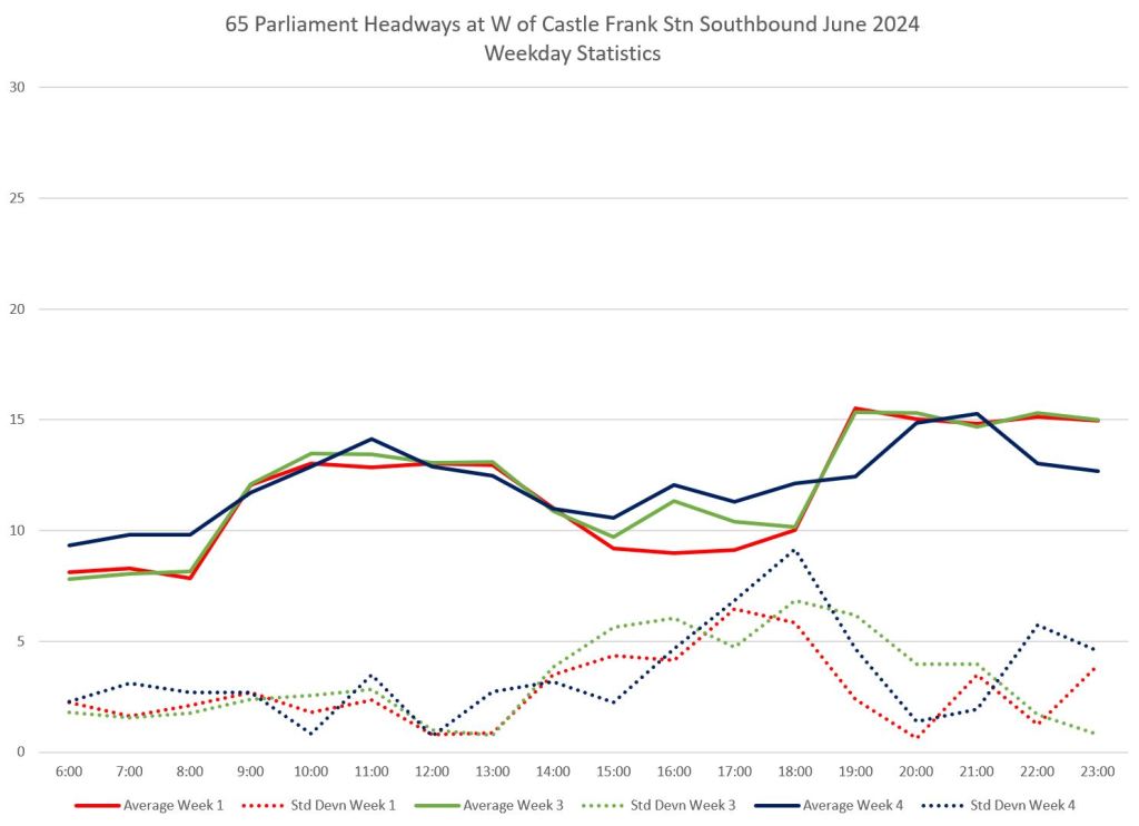
Service on 65 Parliament
The 65 Parliament bus, like other waterfront routes, can be affected by congestion, but not to the same degree as it only runs west to George Brown College / Corus Loop near Sherbourne. The standard deviations of headways from both ends of the route rise to close to 10 minutes (indicating a range of 20 minutes around the schedule for most trips) during the PM peak. This affects not just riders at Queens Quay but over the entire route.
Week 2 is omitted because of missing data and construction diversions.
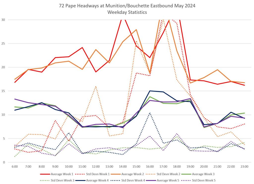
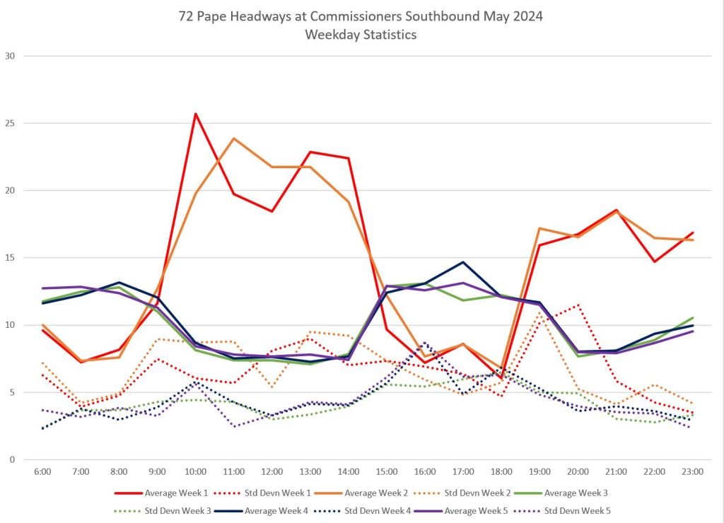
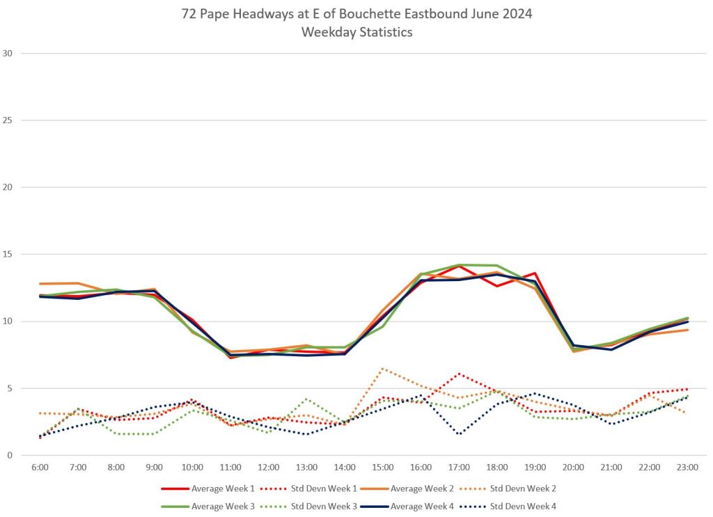
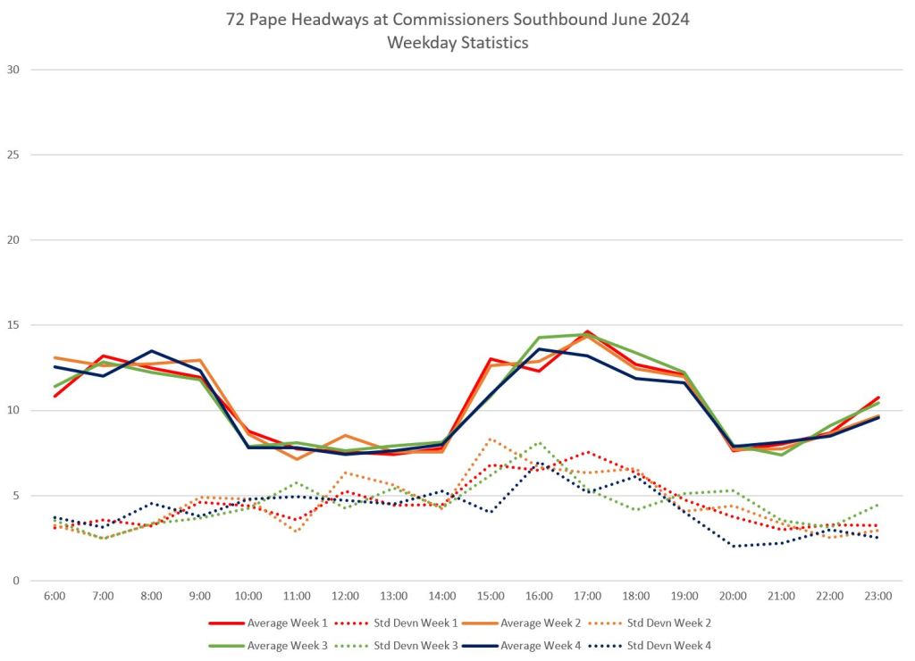
Service on 72 Pape
For comparison, charts are shown here for May and June 2024. The route was shortened from Union Station to Villiers Street in mid-May, and the service was improved from the previous arrangement of uncoordinated Eastern and Union branches.
At Queen, the standard deviation values are higher for the first two weeks of May reflecting the difficulty of keeping the route’s branches on a regular spacing even when this was scheduled. From mid-May onward, the SD values are better behaved. Southbound values are higher than northbound reflecting that Queen is almost the end of the route which originates in Thorncliffe Park, and the evenness of bus spacing tends to deteriorate along the length of a route.
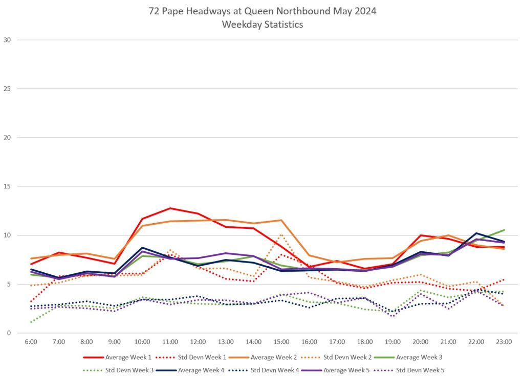
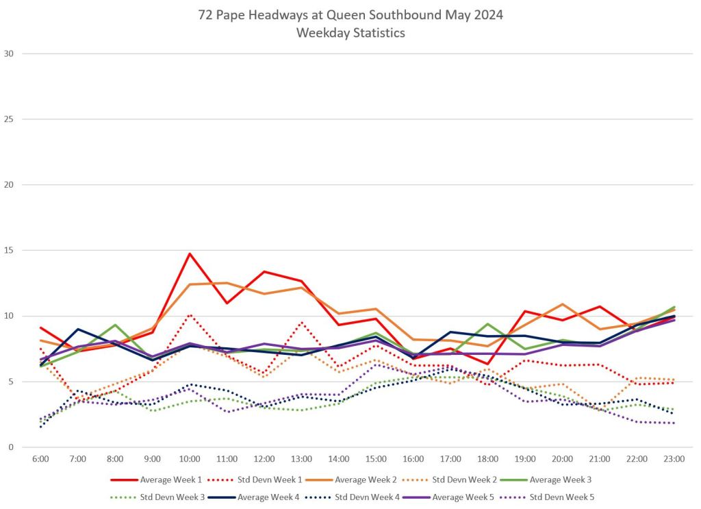
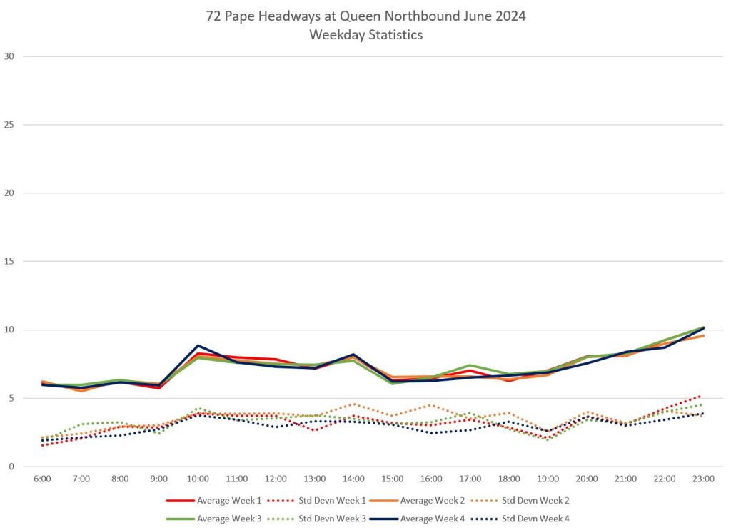
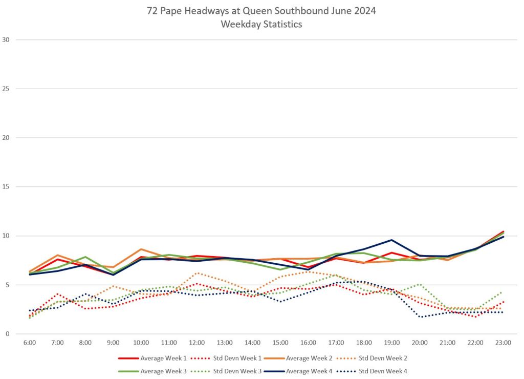
Service on Commissioners changed quite substantially with the new schedule in mid-May. The former 72B Union Station service was often mired in traffic and very unreliable.
Note that the peak period headway is wider than off-peak because some peak service turns back at Eastern Avenue while all off-peak service runs through to Villiers.
Service on 75 Sherbourne
Route 75 Sherbourne is routinely snarled in traffic backed up for the Gardiner Expressway on ramp at Jarvis Street westbound. This affects PM peak service reliability northbound as seem in the rising standard deviation values. Service southbound from Bloor Street is not as bad, but as on 65 Parliament, this is a route that suffers because of unpredictable conditions at the south end.
That said, this route can be unpredictable even when there is no congestion, a problem compounded by infrequent service. That is a subject for another article about badly-behaved short routes.

I have taken the 114 from Union to Commissioners/Bouchette, and will be doing so the next two weeks.
Mornings are fine, I don’t know about gaps but the bus eventually shows up and makes good time.
Evenings, riders need to figure out where they should get off and walk, if their goal is Union Station. Somewhere east of Jarvis is a pretty safe bet for any moderately fit walker to leave the bus in their dust. One day when there was a dump truck disaster on the Gardiner, the smart place to get off would have been Cherry at Lake Shore because from there to vaguely Yonge St took 45 minutes if not more.
My one experience trying to catch a northbound Pape bus from Commissioners and Bouchette was that you would get fairly old before you actually got to get aboard a bus. The schedule claims 13 minute headways but it was a lot longer than that before a bus showed up, and there were several people waiting when I got to the stop.
I will probably try again and see how it works in the next couple of weeks. For some reason, trackers were not working at all accurately to predict the arrival of a bus. Partly that might be due to layovers and unpredictable departures.
Steve: When buses take a layover at the terminal, the tracker has a hard time knowing when they will show up at downstream stops until the vehicle actually starts to move. Even worse if it is badly off schedule because there is no “anchor” for the prediction.
LikeLike
Steve said:
Service on 75 Sherbourne
Route 75 Sherbourne is routinely snarled in traffic backed up for the Gardiner Expressway on ramp at Jarvis Street westbound.
I agree that the 75 gets snarled but it’s not on Jarvis northbound, it gets caught in the solid traffic going west on QQE between Lower Sherbourne and Lower Jarvis. The northbound traffic on Lower Jarvis is generally NOT the problem and it is the southbound traffic on Lower Jarvis (where there is no TTC service) that backs up for the Gardiner westbound on ramp.
Steve: The last time I was there, traffic attempting to turn off of Queens Quay onto Jarvis blocked through movements east-west because there was not enough capacity to absorb cars trying to drive up Jarvis. All part of the same problem.
LikeLike
We, the lowly plebs, who work for the TTC, cannot understand why the bus stops at Carlaw, instead of looping Carlaw, Lakeshore, Leslie and Commissioners St.
It would serve two TTC divisions and give twice the options for the other companies’ workers in the area.
LikeLike
The city is walking into another Liberty Village/Humber Bay Shores situation in the Portlands and eastern waterfront. If rail transit is, at best, a decade or so away, there should at least be dedicated bus lanes provided in the interim.
Steve: The use of a future streetcar right-of-way by buses has been discussed in various planning sessions, but the problem is how to access Union Station. This whole project is an example of how constant deferral and half-measures compound into an LRT project I begin to doubt we will ever see. This is not helped by Ontario Line proponents who treat their route as the magic solution to all waterfront transit even though it is on the other side of the rail corridor.
LikeLike
I wonder if they could get away with not having a direct connection to Union? A good bus link into East Harbour station will solve a lot of transit connections, assuming East Harbour is less late than Eglinton Crosstown. And on the other end, going up Cherry then along King transit corridor – if we could keep its intersections clear for transit…
But just to be clear, I do think Portlands residential development really needs the LRT. I wonder how much buyer demand is suppressed because the LRT isn’t there. “Investor” buyers probably don’t care as much, but they are currently not doing great financially…
Steve: The Cherry/King connection is likely going to be part of an early stage for the LRT, but even that is fouled up by construction conflicts from the Ontario Line and the Gardiner rebuild for the immediate future. For far too long, the LRT was looked at as only serving the area to just west of Parliament (Small Street), and going to Villiers and beyond was for the future, hence less pressure to “do it now”. The future will occur while we are still waiting for the LRT.
LikeLike
Not more streetcars!!! NOOOOOO! Unless they build a dedicated lane, not like the disaster at Harbourfront that is absurd to navigate and not like Spadina that is a challenge for pedestrians and bicycles to cross, not like……. The list goes on. Basically, NO MORE!!!!
Today while bicycling to work the streetcar stopped twice in two blocks but for a change they did NOT keep their red lights flashing long long long after they finally closed the door long long long after the last person exited or entered. It’s a power trip many streetcar drivers play. And then they race while I race, trying desperately to get ahead of them before I hit the parked cars. I’ve see. This so many times. I hate streetcars. HATE. They plug the roads. Can’t move around a left turn. They only work if you remove all other vehicles from the road. But if you take out everything from bicycles to delivery trucks you could have an excellent service!! This morning I noted a driver not trying to fuck the traffic!! Means they CAN turn those bloody lights off and shut the frigging doors!! (Not in that order.) I’m one of many pawns played with on the road – in a car, on a motorcycle or bicycle. NO MORE STREETCARS!!!!!! It’s like a disease. Why would we want MORE?!!!!!!!!! 😉
There. I said it. We’re still friends cause we’ve always still been friends. We just don’t love streetcars equally!! 😉
Steve: No more cookies for you!
LikeLike
Is this 114 a permanent change or is it long-term temporary until the problems that the Gardiner construction is causing in south downtown end?
Steve: I believe that this is permanent to slice 72 Pape and 19 Bay off from traffic in “South Core”.
LikeLike
I used to have a one seat ride from Sugar Beach to my work on Bay and Wellesley on the 19. Now I have to transfer to Union. This adds so much more time on to my trip. Time to move.
LikeLike
I have certainly tried to race streetcars while on a bicycle and missed getting past them before the next stop by thaaaaat much. It’s pretty annoying, as when I do get past them, they never every catch up, they just drop further behind.
But of course this is not the case on Spadina or Harbourfront or St. Clair, where the stops all have safety islands. I believe the big impediment on Queens Quay is all the traffic lights which the cycle path, in theory, will have to stop for if they are red.
Crossing Spadina is a pain because the street is so wide. Streetcar or not has nothing to do with this. I’m sure it was a real treat to cycle back in the days of angle parking and a zillion fume-belching GM New Look buses (6V71 is not a clean engine).
Can *I* get the biscuit, then?
LikeLike
Let me harp, again, about the 121, which was eviscerated in the name of efficiency. Yes, it was impossible to keep on time because the city wouldn’t dare limit auto traffic on Front for fear of offending the valuable 905 vote — seriously, look it up, 905ers are allowed to vote in Toronto municipal elections if they have any property or business in the city. Dafaq?
Anyway, to the east, it used to serve Distillery and Cherry Street, with an extension to Cherry Beach in the warmer months. To the west, all the way down to Bathurst/Fort York. It provided a ride all across the bottom of downtown. Not along the lake, which is nice if you live down there but too far south to be useful to non-residents of QQ.
The current rump of the 121 is now just a shuttle between Distillery and Union and not even a very good one with many stops being removed. I can move around the area fairly well, having good mobility, but I know many seniors/disabled whose world has shrunk.
LikeLike
The area of Eastern Waterfront is doomed until the dream of streetcars becomes true. Every weekday afternoon hours QQE and Lower Jarvis are fully jammed. Riding on a bus or car to Union Station at this time 99% takes longer than walking, where the latter costs 20-30 mins. The issue is beyond the bus network and will infinitely stay there, as long as the transit keeps sharing the same space with other vehicles.
I used to ride on buses 19 along Bay St and 72 to Pape Station, so I was left with the only choice to go to Union Station after the change in May. I’d say the new route 114 does bring slightly better frequency and reliability for many periods in exchange for convenience, so one can still call it a tiny improvement if they have an optimistic mind. Of course again traffic gets into a mess all the time during PM peaks and weekend afternoons so the benefits are offset.
I can see how the idea came from – to minimize the impact of traffic to other areas (especially along Pape). But route 19 becomes useless since then… if nobody (or only a very few) rides on the bus, who’s actually getting benefits from it?
Patrick wrote:
I’d guess it just lets drivers enjoy a cup of coffee from the Tim Hortons nearby.
LikeLike
How is the 114 actually working from a regular riding perspective?
Tuesday it worked fine. That was an unusual day.
Wednesday (yesterday) I went out to wait for a westbound 114 at Bouchette, shortly before 6 PM. The bus showed up at 6:25, a headway approaching 30 minutes. It took to about 6:50 to get to Union station, a trip of 25 minutes.
Service summary claims headways of 12.5 minutes. Yeah, right.
I will note that it took at least 20 minutes for the first 72 Pape to go by the other way, followed by another one a couple of minutes later. That’s a 13 minute headway route.
Does the TTC scheduling account for severely assymetrical travel times? The 114 can be extremely slow in one direction or another. Of course sometimes it’s extremely slow in both directions.
There’s a *lot* of cyclists passing by on Commissioners. Some of them might be out for exercise, but many are on bikeshare bikes. I guess it’s not surprising, you can pretty much guaranteed cycle to and from downtown quicker than the bus, or even driving your own car (or taking a cab).
Finally, I think the 114 gets far enough behind schedule that the prediction applications like Transsee get confused. The vehicle locations are accurate enough, but Transsee’s guesses as to which bus is coming next, and how soon, are wildly off. I don’t think a bus at Yonge and Queens Quay will be coming by eastbound from Carlaw in the specified 1 minute to 1 hour time frame!
Steve: Looking at the vehicle tracking for 114 yesterday, I see that for much of the day there was a pair of buses running together, and three of the four in a pack was not unusual. A basic problem with TTC line management is that they don’t space vehicles, and the schedule be damned, to provide an even headway. Having said that, yesterday was certainly unusual with flooding screwing up a lot of service, and TTC service management stretched thin. I plan to review the waterfront services again in a few months.
As for 72 Pape, it looks like a few buses that should have run through to Commissioners were short-turned or missing.
LikeLike
I sometimes despair when i try to suss-out what is driving Toronto public policy, and the eastern waterfront is one good example.
(I frequently read this blog, but seldom contribute. but today I’m going to treat it as a personal soapbox in search of feedback)
I’ll start off by saying that I conceptualize good city planning as being “results oriented”, eg. regardless of the mode of transit, competing interests are being balanced so that people can “get where they’re going” in a timely and safe manner.
Eg. the streetcar network should run smoothly and reliably, and we should re-consider auto-driver left-turns at certain locations, or farside stops on Spadina streetcar routes;
Eg. 2. start-to-finish routes need to be available to cyclists so that they can safely and effectively navigate the city. Having protected lanes that suddenly have them being spit into the closing jaws of heavy traffic in un-protected lanes doesn’t make sense.
In practice, I’ve found that my “let’s make things work” attitude runs afoul of people who are more ideologically driven (eg. “we need a bike lane on every street in Toronto goddamnit, and anyone who doesn’t like the traffic standstill should just take a bicycle next time”)
Personally, I usually drive around Toronto. This decision is pragmatic. A 20 minute drive vs. 1.5 hour TTC ride? the decision is obvious.
I’m living in the entertainment district, and over the years my frequent destinations out east would be Keating Channel Pub in the port lands, or Rock Oasis (Dundas/Carlaw), or other spots in Leslieville, etc…
Now, how have things changed in the past few years?
For one, Toronto decided to tear down the on-ramp to the Gardiner westbound from Lake Shore/Logan avenue. I understand it’s to free up land for condos and businesses etc… , but what are the options for motorsists coming [from] Lakeshore/Carlaw trying to access the Gardiner?
To me it doesn’t make sense. Toronto already has world-renowned bad traffic. Why are they intentionally amputating their own transportation infrastructure?
It’s even worse with the eastern waterfront.
Two weeks ago I tried to visit the Keating Channel Pub. After sitting for 20 minutes in standstill traffic on Commissioners, we just abandoned our destination and went somewhere else.
And what other options are there to reach the port lands? Auto traffic has been reduced from two lanes to one lane on Commissioners (PERMANENTLY, not just for construction), which is the same traffic the buses sit in. As Steve indicated, there won’t be streetcar service to the port lands earlier than 2036. Is this just the sad new reality?
It sure sounds nice to “just get on a bicycle”, but an hour bicycle ride from home with inlaws simply is not realistic for a lot of people, myself included.
In effect, the re-design of the road network in the port lands has created No-Go zones. And the port lands never used to be this way.
Why is it this way? Are Toronto city planners slaves to insistence that auto-traffic should be reduced to 1-lane to make it SO BAD that people just give up taking their cars?
(If that’s the strategy, as messed up as it already sounds, then why the hell are there not reliable alternative transit solutions available???)
It really does make me despair about the state of city planning. I’m sure the eastern waterfront will be lovely when it’s finished. But if it’s completely inaccessible to all but eternally patient Buddhist monks, then what’s it worth?
The port lands used to be VERY accessible by ANY MODE of transportation. And now I find myself needing to find new business to frequent. Why did the city dispense with the “get where you’re going” desired outcome in favour of this grid-locked catastrophe?
LikeLike
It’s mostly because the cost of rebuilding it. As people have noticed, many of the elevated parts of Gardiner need to be rebuilt, because they are 60 years old and otherwise they will fall down. The part through Parkdale is currently being rebuilt to much wailing and gnashing teeth. The part east of Jarvis eventually needs to be rebuilt (if it didn’t need to be rebuilt, it probably wouldn’t be getting realigned). The part east of the Don also needed to be rebuilt, but the benefits of keeping it didn’t warrant the cost of the rebuild. So it was not rebuilt, and instead torn down. It was about money. Roads cost lots of money. Elevated expressways even more.
Having people “give up taking their cars” is in fact an explicit City goal. The TransformTO goal is to have “75 per cent of school/work trips under 5km are walked, biked or by transit”. 5 km includes Richmond and Spadina to the Keating Channel Pub.
Frankly, because in Toronto politics, setting lofty goals is easier than spending money to reach them. Fiscal conservative politicians are mostly not opposed to setting lofty goals, but they are opposed to spending money on transit. The result is that car access is restricted following TransformTO policy (often improving bike access, although piecemeal), but we don’t get better transit.
First of all, as someone who went to Polson Pier a couple of times around 2010, the assertion that it was very accessible by transit is… interesting. Certainly there was a bus. 900 metres away at Commissioners and Cherry. Every 15 or 20 minutes or so? When events let out, you wanted to speed-walk to the bus stop, because the first bus that came would fill up and leave passengers behind.
The Portlands are being rebuilt. It was a very low density area, largely due to risk of flooding. The threat of flooding is being addressed by the Don mouth rebuild, which unlocks uses of land which are more “economically productive”. That means more people, more businesses, and more property tax. Look at Humber Shores (area around Lake Shore Blvd and Park Lawn, Marine Parade) to get an idea. BTW, the same thing happened a couple of decades ago when downtown condos were built up: residential use was more economically productive than railway lands (which thus became CityPlace) and warehouses/light industrial (which became the Entertainment District).
To put it frankly, maintaining access for people who want to drive to the one pub that’s currently there isn’t a priority.
The priority is building apartments and retail space to service people living there, preferably without a car (see TransformTO goals). Nearly no one living in new Portlands will ride a bicycle for an hour anywhere. Pubs and coffee shops will be within walking distance. The worst case grocery stores, the current ones around Leslie and Lake Shore Blvd, will be a 15 minute bike ride away, and I really hope the build-out will include a couple of local groceries like you see at Liberty Village or King West.
Where I agree with you is that access out of the area is a necessity. Many of the people living there will work somewhere else. We can see that high-density residential areas in GTA basically don’t work without transit — downtown Mississauga with its towers and Square One was legendarily clogged with cars even before the LRT construction, and that’s in a city no one would accuse of being ideologically opposed to cars. That’s why good transit is such a priority, and why it’s very distressing to many people to see foot-dragging on transit to Portlands.
LikeLike
@ Jarek
I appreciate you weighing in. I suppose I’ll just have to conclude that I disagree with the city’s goals, or at least the way in which they are choosing to implement them.
Maintaining access to a neighborhood is more than “maintaining access to drive to one pub”… it’s maintaining access to the neighborhood in general.
Even if there wasn’t a decade-long delay for the streetcar to arrive to the port lands, reducing traffic lanes to one lane only is bad design.
(What happens when the streetcar line is down such as the construction on the Spadina ROW right now? Where will the replacement buses go when there is intentionally no spare road capacity?)
Choosing to have only one lane of traffic is choosing to snarl the neighborhood, and whatever bus, taxi, Uber services, etc… that have to share it.
And as nice an idea as it sounds to have everyone come in on bicycle, that’s not an option for a lot of people. My in laws or grandparents come to mind, but obviously there are a lot more mobility impaired people who simply cannot bike or walk 5km.
Instead of making the city more connected, these policies are creating islands within the city.
As an aside, when I said the port lands used to be accessible by any mode, I was referring to available road space. There was nothing to stop the TTC from running more frequent service, or shortening the distance from Polson pier/Rebel to the nearest bus stop (nothing except for the TTC itself that is…).
Nor would I suggest that the previous road-sharing setup amongst various was optimal.
But shrinking the road space simultaneously with densifying the neighborhood is just “creating congestion”, and I think it’s idiotic.
Steve: One point worth mentioning is the design of new streetcar rights-of-way. I know there has been talk of interim use by buses before the LRT is up and running, but I wonder whether the design takes the clearance requirements into account. I will have to ask.
LikeLike
Again I say: we have seen that more car lanes does not mean easier driving anywhere in the GTA.
Bremner Boulevard has 2 lanes in each direction. Is driving on it easy? Spadina Avenue has 3 lanes in each direction south of King. How is that going? Front Street? Hurontario? Highway 7?
We will never have enough car lanes if we make cars the main way people get around the city. How wide is the 401? How is that going?
The goal is to get as many people as possible to not drive. Period. And a good starting point is not designing streets and roads like in the 1960s. We’ve learned that more lanes create more driving. So we’re not doing that anymore.
There’s no such thing as “spare road capacity” in Toronto. All available road capacity is taken up by car drivers due to induced demand. The only exceptions are stretches drivers can’t reach due to traffic elsewhere. Does the six-lane Spadina Avenue have “spare road capacity”? Can you think of any street designed for through traffic that has “spare road capacity” today?
As for when the streetcar line is down: one solution would be to block off the car lanes altogether and only allow in buses, drivers with accessibility permits, and people who actually live there (remembering that relatively few residents will be driving because the neighbourhood will be walkable). Just as we should do on Liberty Street today, but I digress.
Even if that were true… What about the rest of the city? If we made the new Portlands great to drive cars in, then lots of people would want to drive there. So how would you get there, and how would you get out? Gardiner and DVP are already full today. There’s physically no room to widen the Gardiner or the DVP or Lake Shore or Jarvis or Broadview or Parliament without bulldozing hundreds of millions of dollars’ worth of existing buildings. There’s also no capacity at intersections without building huge and expensive overpasses. Where would the cars go? How much would it cost?
That’s clear to everyone. That’s why the official goal is 75% of short commute trips, and not 100% of all trips ever, and why that 75% includes transit trips. Your grandparents can be in the 25%, and their taxi in will be easier if people who don’t need to drive, don’t.
You wrote that you were “sitting for 20 minutes in standstill traffic on Commissioners”. You weren’t “sitting in traffic” — you were the traffic. If someone needed to access that area for their job, or because they have a mobility issue (i.e., they have an accessibility permit), then you were delaying them by choosing to drive on a whim. And that was also the case on Adelaide or Front or Lake Shore or any other route you took. You are the traffic. Change starts with you. If you don’t drive, people who genuinely need to drive will find it easier.
Hm, I missed “theoretically” in your message “VERY accessible by ANY MODE of transportation”. But among the same lines, there’s nothing stopping drivers from driving at 6am on a Sunday. There’s available road space! You can feel like you’re in a car advertisement! Nothing except the drivers themselves…
Look I’ll be frank. If you feel that my neighbourhood is an “island” because you can’t drive through it easily, I’m not sorry. Too many cars ruin neighbourhoods. For people living here, less through cars means less speeding drivers, less aggressive honking, less insisting that children must tightly hold parents’ hands and not play at all times, less deaths at crosswalks.
Steve: And my only caveat is that any future “LRT” rights-of-way must be designed such that they can be used by buses when needed. The whole idea of forcing transit out onto the general road lanes is ludicrous.
LikeLike
@ Jarek
You’re making a weird false equivalency between road space being available to be optimized later (vs. intentionally snarling traffic by reducing capacity to one lane) and driving at 6 in the morning (vs. driving when businesses are open and you can participate in commerce or other regular daytime activities).
I’m trying to zero in on design considerations. For example, if we say that Bloor-Yonge subway station is over-capacity and dangerously overcrowded, then we should think about how we can solve that problem (platform expansion, relief line, etc…). Telling someone to take the subway at off-peak times is missing the point. And taking away a lane of subway track at Bloor-Yonge to make alternating single-track usage (which would cut capacity) would not address problem of overcrowding.
(I understand your argument that cutting capacity will eventually reduce overcrowding. Take away that subway track, and make it SO BAD that thousands upon thousands of people will permanently abandon taking the subway through Bloor-Yonge, and Voila! Your dangerous overcrowding problem is solved. I DO UNDERSTAND the strategy…. I just think it’s a REALLY BAD strategy)
Let’s compare traffic to the blood circulation system of the body (where we have big capacity arteries that feed the lower capacity capillaries). When we reduce the capacity of our arteries, we’re essentially turning arteries into capillaries. And that doesn’t support the greater network. If we CARE about the flow, we don’t stifle the capacity. Heart surgeons do “triple bypasses” to improve flow…. not “artery obliteration” to reduce flow.
I agree with you that residential streets should have traffic calming zones so that children don’t have to grip their parent’s hand too tightly. But having a mix of arteries (for people to come in and out) and capillaries (where the streets become livable) supports the greater network. And that situation is different form an all-capillary, choked-capacity neighbourhood.
I’ll go one step further and label the notion of creating all-capillary neighbourhoods as “island thinking”. Your ideas to fix Liberty Village (only allow in buses, drivers with accessibility permits, and people who actually live there) ignores the reality that the road network is NOT just for the people that live in that local neighborhood. It is also for people coming from elsewhere in the city (or out of the city).
Part of the city’s job is to look out for ALL the users, not just their favourites.
I had abandon my drive to the Keating Channel Pub. That’s too bad for the pub. I sincerely hope they’re not struggling to stay in business.
Before there was a situation that worked pretty well. And now it’s much worse. (And it doesn’t seem like there will even be alternatives available any time soon).
Perhaps the city planners can explain to business owners that their absent customers didn’t “genuinely need to drive” so they’re not coming. I don’t think they’ll feel better when they hear that.
LikeLike
@ Jarek
Let’s do a fun hypothetical.
Before Doug Ford’s government rescued the Gardiner east of Cherry Street, there seemed to be a real threat that the seamless flow of two massive arteries (DVP and Gardiner) would be downgraded to a lower capacity connection via Lake Shore.
What if the same thing was happening with Chester station?
That subway station isn’t too busy, after all. The cost to revitalize the station is very high. It would be better to tear out the tracks between Broadview and Pape and replace it with a shuttle bus.
Let’s thicken the plot: maybe the city has a new policy to get 95% of all trips to be on foot or on bike (It’s better for your cardio health after all.)
And besides, the shuttle bus connection between Broadview and Pape is projected to add only 3-4 minutes to your trip (er….. on average)
So let’s say you’re in this conundrum, stuck on this packed shuttle bus between Broadview and Pape. You’re sitting there and you say: “Man this is really crowded! This is a lot worse than before. This kind of sucks!”
And then some holier-than-thou voice says: “Jarek, it’s not crowded, YOU ARE THE CROWD. Be the change you want to see in the world. Get those sneakers laced up, bruh. Or maybe get on a bike next time, bruh. Besides Jarek, there’s nothing stopping you from taking the Broadview-Pape shuttle bus at 3 in the morning. Next time plan better”
I’m guessing you wouldn’t be too pleased.
But don’t worry, I would be right there with you to:
LikeLike