
At its meeting on October 25, 2023, Toronto’s Infrastructure and Environment Committee will consider a report about the City’s Congestion Management Plan. I will review that in a separate article, but to set the scene, it is worth looking back at the success and failure of the King Street transit priority pilot.
The original idea was to establish King Street, by far the busiest streetcar corridor downtown with consistently high demand, as a mostly-transit street to speed trips through the core area. A combination of forced right turns, enlarged boarding areas at stops, together with other road changes would make travel by car between Jarvis and Bathurst Streets difficult, if not impossible.
The scheme was quickly watered down thanks to protests from the taxi industry, including carriers like Uber whose vehicles were not branded, and this presented an immediate problem for enforcement. That problem was compounded by the lackluster efforts of Toronto Police who had more important things to do with their time. Occasional blitzes were separated by long periods of laissez-faire non-enforcement.
Despite these limitations, the changes actually did improve travel times, and in particular, the reliability of travel times, over the affected section. Then came the pandemic, and traffic downtown evaporated along with any vestigial efforts to enforce traffic laws. Motorists became used to driving as they pleased, and that has survived into the post-pandemic period along with the unsurprising result that many benefits of the transit priority scheme have been lost.
This article looks back at the actual data for 504 King cars operating through the core to show how travel times have evolved. I have included data going back well beyond the implementation of the King Street transit priority pilot in November 2017. Some of these charts appeared in earlier reviews of King Street, but they are included here for “one stop shopping”.
All data for the analysis here were supplied by the TTC from their CIS and Vision vehicle tracking systems, for which much thanks. The presentation and conclusions are my own.
Travel Times From 2016 to 2023
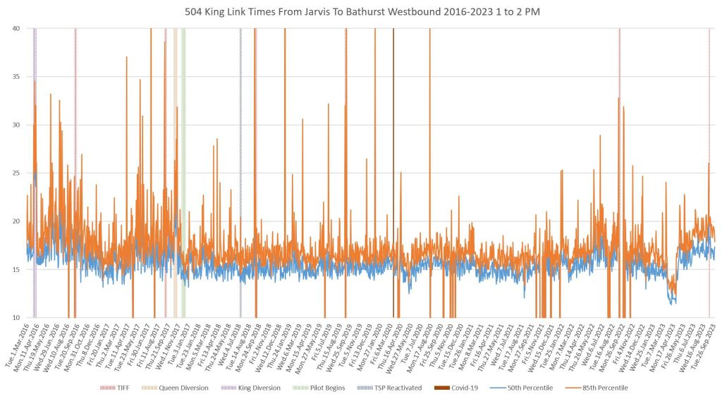
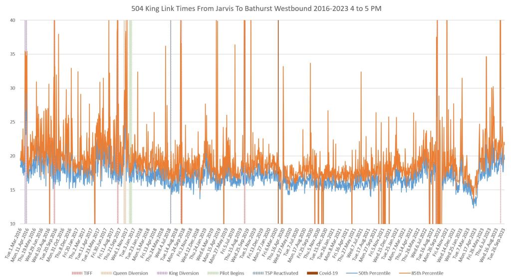
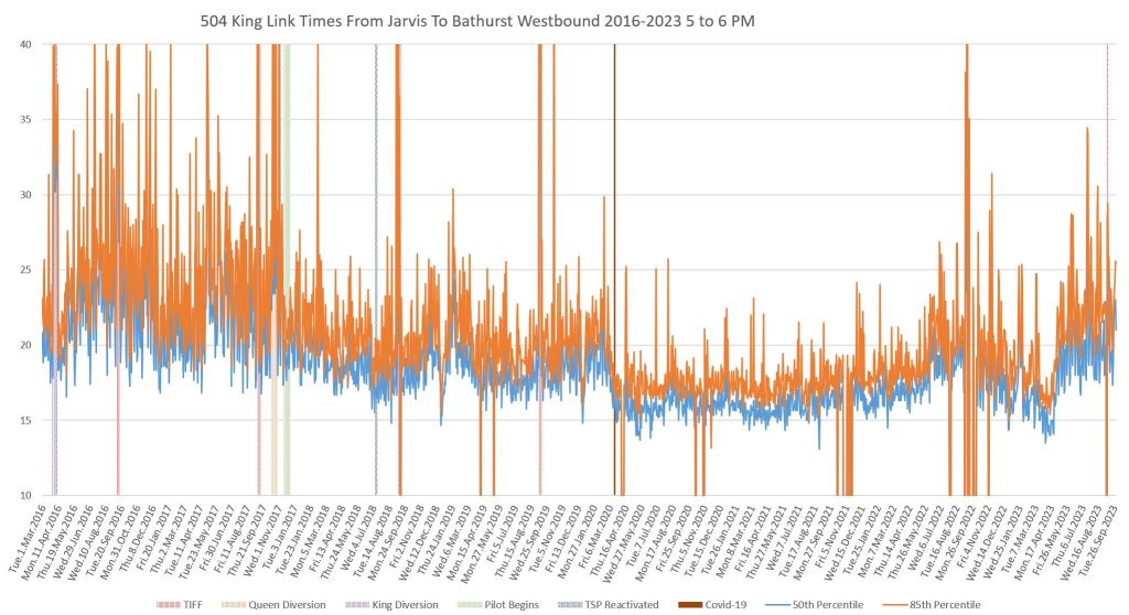
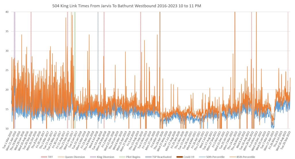
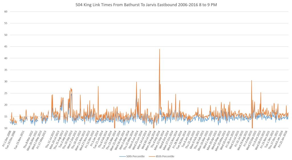
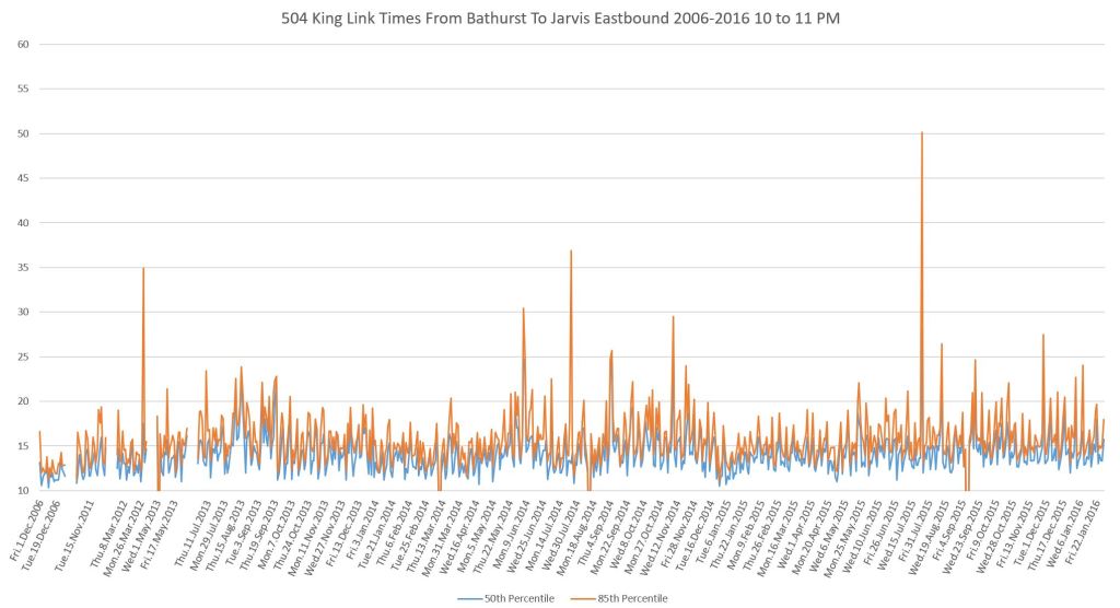
The charts below show the travel time data for streetcars between Jarvis and Bathurst on weekdays from March 2016 to September 2023. The blue lines track the median value (half of the trips are faster, and half are slower) while the orange lines track the 85th percentile to show the upper bound within most trips fall.
There is a pair of charts for westbound and eastbound travel with data shown for selected hours in the day:
- 8 to 9 am: The AM peak
- 1 to 2 pm: Midday
- 4 to 7 pm (three charts): The PM peak and transition to evening
- 8 to 11 pm (three charts): The evening period including the effect of the Entertainment District
Significant events include:
- November 2017: Pilot implemented (vertical green bar). Note that the transition occurs over several days as the physical changes were not all implemented at the same time.
- July 2018: Transit Signal Priority was reactivated at those intersections where it was in force before the pilot, but, astoundingly, was turned off when the pilot began (vertical blue bar).
- March 2020: Pandemic lockdown.
- January-April 2023: Major disruption, rerouting and bus substitution during and following repairs to a major water main break at King & University.
- Early September 2016-2019, 2022-2023: Toronto International Film Festival (vertical red bars).
- Holiday traffic lulls in late December of several years.
Several points should be noted about the behaviour of these data.
- The effect and benefit is far more pronounced in the afternoon and evening than in the AM peak. This reflects the level of non-transit traffic downtown which, during the AM peak, gave little problem to transit operations. In effect, there was not much to “fix” in that period.
- The variation in travel times before the pilot was implemented was much higher (as shown by the high values for the 85th percentile) than afterwards. This translated to more reliable service over the entire route because service evened out and fewer short turns were required. Ridership went up on the route as a whole because of better reliability, not just in the core area.
- The onset of the pandemic caused a steep drop in travel times, most notably in the afternoon and evening periods. Travel times have risen gradually over recent years, but the lower overall traffic level during the pandemic masked the effect of poor enforcement of the priority scheme.
- Travel times in April 2023 were lower than surrounding months because this was a period when only buses operated on King Street due to various construction projects and diversions. I will explore this in more detail later in the article.
What is most troubling here (and is evident to anyone who uses transit service on King), is that since May 2023 travel times are rising, but worse the 85th percentile values are growing back to pre-pilot levels in some periods. Some transit priority benefit is lost as traffic builds up and motorists treat King Street like other streets downtown.
Another factor here is that the closure of Queen Street for Ontario Line construction in May, and the ongoing works on Adelaide Street (for water main replacement, utility relocations and track installation for the OL diversion) leave King as the only relatively easy route through downtown. We will not know what the “new normal” will look like until work on Adelaide completes late in 2023 and that street can return to fairly normal operation.
Hard decisions are needed by City Council on how aggressively King Street transit priority will be enforced in coming years. Talking about tweaks here and there to signals and parking addresses usually small, one-time benefits, but without enforcement of transit’s priority, King Street’s transit service might not return to the balmy days when so much improvement was anticipated in late 2017.
(Click on any image to open the charts as a gallery.)


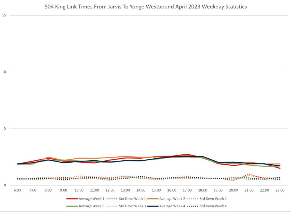
April 2023
The charts above all show a dip in travel times in April 2023. This actually lasted from the last week of March to the first week of May corresponding to one period in the TTC schedules. During that time, only buses operated on King while the streetcars were shifted to Queen Street.
Note that the origin of the y-axis is at 10 minutes, not zero, to give the data values more “elbow room” on the charts. The April 2023 dip appears larger, proportionately, than it would if the y-axis began at zero.
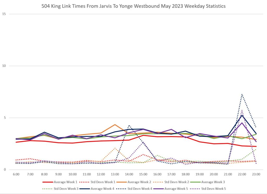
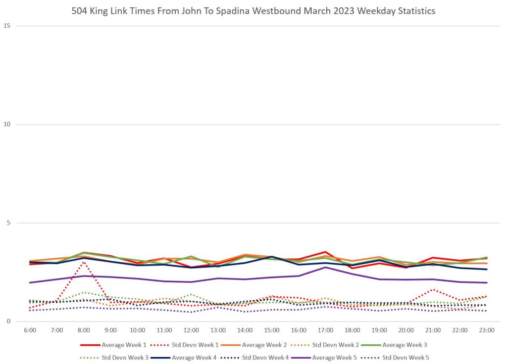
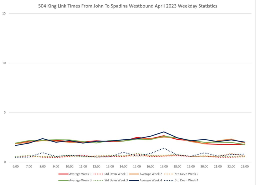
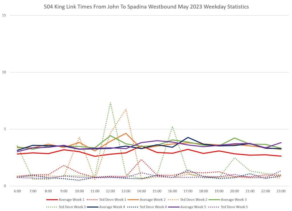
The change in travel time was not even in all segments as the charts below show.
These charts divide the route into five segments vertically and three months horizontally. On all charts, the solid lines show the average travel time by hour for each week, and the dotted lines show the standard deviation of values (a measure of uniformity).
Within March 2023 (left column), week 5 (purple) is operated with buses. In three cases the buses run slightly faster than streetcars, although in one (John to Spadina) they are slower.
Within April 2023 (middle column), the travel times are consistent for each week, and are roughly at the same level as the week 5 data for March.
Within May 2023 (right column), week 1 (red) operated with buses. In some, but not all, segments the buses are slightly faster.
Travel times for buses in this are are affected by several factors:
- Buses are not subject to the TTC’s standing slow order on all special work (intersecting tracks), and this allows them to operate at normal speed across Church, York and Spadina.
- Bus operators have a tendency to drive as fast as possible, especially when the street is not congested, whereas streetcar operators tend to drive more slowly.
- At some locations where streetcars regularly make turns (Spadina westbound, Church eastbound) there is no transit priority signal. Not only does this slow the affected streetcar, it can backlog all transit traffic on King. Buses are smaller, and in spite of the lack of TSP, they can generally clear intersections when turning more quickly than streetcars.
For some segments, the SD values in May bounce around a lot because there were some 504 buses which took long layovers, but this counted toward their travel time across individual segments. This did not affect the charts above for the full Jarvis-Bathurst travel times because these buses generally turned back and did not make the full trip across all segments.
The spike in the Spadina-Bathurst data for week 5 in May was caused by a lengthy delay westbound on King at Bathurst on May 29 causing many vehicles to record long travel times between Jarvis and Bathurst.
(These are examples of the challenges of dealing with tracking data and filtering the outliers. I have left the data points in because they do not affect the overall behaviour I am illustrating here.)


King Street Before 2016
The charts in this section show examples of travel times in various periods from late 2006 to early 2016.
- Note that the upper end of the y-axis is 60 minutes in these charts compared to 40 in the set above to give room for the very high values of some data points.
- The effect of the Entertainment District is evident for westbound data in the evenings with regularly spaced peaks corresponding to extra traffic primarily on Friday evenings.


According to our BIA, King Street (at least in the Yonge to Parliament blocks) will be getting a new TTC tracks, new watermain etc in 2026 and the street will then be reconstructed with wider sidewalks and more appropriate corner radii. The BIA are also pressing for the transit mall to be extended to the new Ontario Line station at Berkeley/Parliament.
Steve: That’s going to be a fun project with Queen Street still closed for OL construction. I am also willing to bet the TTC will discover their short-sightedness in failing to install a few key curves at York Street.
LikeLike
Is anybody talking about photo enforcement for King? It shouldn’t be that difficult and it would free up police resources while relieving of them of an excuse. I was going to tweet the question, but it seems my tweets are only of interest to nubile young bots with single-digit follower totals. SW
Steve: I am neither young nor nubile, but do read your tweets 😉
Photo enforcement would be an interesting challenge as there would have to be a reliable way to identify a bona fide “taxi” including the constantly changing fleet of Ubers.
LikeLiked by 2 people
Before poring over the excellent analysis, I have to comment *subjectively* as an avid cyclist (albeit old-school, following the traffic rules) as to how the King Corridor has gone awry, not that the City ever did allow it to be what is should have been from the start.
King, tracks beside, which combined with the CafeTo patios, was flawed for cyclists from the get-go, and has gotten even worse since. The ‘TTC factor’ has stayed about the same for cycling, but the volume and *attitude* of the drivers not following the law has increased geometrically.
Contrary to the opinion of many, King, pre or post corridor was never a safe street to cycle. That being said, and that many cyclists are forced to use it in lieu of the core becoming a no-go zone, it’s not just the TTC that’s seen a large decline in service level on King.
The Corridor has died from a thousand stab wounds. It’s beyond sad…
Steve: When the King Street Pilot was in early design stages, the idea was that the Richmond/Adelaide pair would provide the bike lanes leaving King for transit and pedestrians. Thanks to never ending condo construction, and more recent utility work, Richmond/Adelaide have left a lot to be desired. I wish we could get back to a “steady state” where the lanes and usage stay put for a while to see what really needs to be fixed. There is certainly a big issue with curb lane occupancy permits for construction that inevitably elbow bike lanes, and sometimes pedestrians, aside.
LikeLiked by 2 people
Hi Steve.
The King Street project, from an Transit Accessibility lens, has been a complete & total issue of neglect.
Let’s not even get into the problems in the winter.
The gorgeous ramp/platforms that were originally built, have been gone for a long time ( replaces with simple black asphalt curbcuts, that are extremely dangerous & extremely difficult to find when someone who needs it, is legally blind, as well as ppl with visual impairments, actually tripping on them), the tactile markings are being destroyed.
Many accessible loading zones are obstructed by bike lane markers or condo construction.
Making life for those with disabilities, who actually REQUIRE the ramps to be deployed, absolute hell.
Lol, people wonder why ppl like me go backwards & resort to wheeltrans….
E
LikeLiked by 2 people
I live at King and Jarvis and often see vehicles travelling with impunity both east and westbound. I can attest that enforcement is spotty. In lieu of police officers, I wish the city would install cameras specifically to fine these drivers. Maybe even post the fine on an overhead sign as a deterrent.
LikeLiked by 2 people
Steve said: “I am also willing to bet the TTC will discover their short-sightedness in failing to install a few key curves at York Street.” I had assumed (yes, I am quite naive!) that they would deal with (and add) York and King curves when they re-do King but ….
Steve: One can hope, but of course the inability to divert eastbound via York and Adelaide will be an annoyance while the street is rebuilt from Church to York. Similarly, the inability to run westbound via Church, Richmond York from King. That would have required foresight now while York is being rebuilt as two way, but only to Adelaide, not King.
LikeLiked by 2 people
Ubers and Lyft vehicles should be forced to clearly ID themselves like taxis if they want the exemption.
LikeLiked by 2 people
Is the taxi exception still only 10pm to 5am? The least we could do is enforce it the other 18 hours of the day.
Steve: From the City’s page on the King Street Pilot:
LikeLiked by 2 people
This so called “pilot project” has been going on for six long years, this is way too long for a “pilot project”. It is time to make better use of this road space on King St especially in light of the years long road closures in place on Queen St, it is time to finally end this “pilot project” on King St.
Steve: If this pilot established anything, it was that putting up signs and painting the road is no substitute for actual enforcement. However, the attitude at City Hall, at least under Tory, is that this will somehow take care of itself. What Mayor Chow will do remains to be seen.
LikeLiked by 1 person
North-south vehicles ‘blocking the box,’ especially at Bay and Jarvis seem to rendering the transit way as useless as cars plowing through the intersections they shouldn’t. At least to my daily observations as someone who lives and works along King.
Steve: These are prime locations for “traffic wardens” we hear a lot about, but never actually see.
LikeLike
King cars could use the 503 trackage to that end. Thankfully the curves exist for Church, Wellington, and York to be used westbound and it avoids travesing more intersections.
If you’ll believe this, vehicles do this everywhere along King. Anybody with half a functioning brain could have seen this coming.
It’s moot now but one of the particularly galling things to me about the planning process for the now-dead relief subway was the cabal of Toronto planning staff who denied the need to more strongly consider King Street for the subway alignment because in their minds the street already had their idyllic transit lanes, enabling the diversion of the line elsewhere. That was quite the backwards thinking.
I think those folks share a lot in common with the TTC desk people-who have proven they do not inhabit the real world-if they thought their ideas would work out.
LikeLike
Having blocked intersections by motorists entering the intersection and still able to see the high raised farside traffic signal. Unlike in Europe and elsewhere, where they use eye-level nearside traffic signals.
When motorists are still able to see the farside traffic signal, they continue in until they are no longer able to see the signal. With nearside, the motorists have to position themselves to where the signals are, at the stop line and behind the pedestrian crossing. With nearside signals, the motorists have to view the signal which are located low next to the pedestrians, when they allegedly stop before making a right turn.
How many times have we seen motorists get a red light, but they cross the stop line and block the pedestrians in the crossing? Because they are able to see the farside traffic signal in the pedestrian crossing, and even in the cross traffic lane.
LikeLike
Why does it feel like we will never get to a point with ‘normal’ streetcar operations. It seems there is just one thing after another. Next will be King rebuilt, than Queen, than….. And don’t forget surprise watermain work. Why does this seem to be such a problem now? What went on in the past? Were things always this chaotic, will we ever reach a point where things run as they should?
There is so much potential for a well run surface rail network in the city. The Waterfront LRT (should it ever get built) will be an amazing addition to that new area. Making it a true transit community, connecting residents right to Union station. If the mixed traffic corridors were given the level of support they deserve, (given the number of passengers moved), we would see left turn restrictions and removal of on-street parking. (A concept that is ridiculous when you think about it.) A city of 3 million, and thousands of people moving along a street every hour. But 1 stupid moron in his Suburban gets to park right on that road. Occupying an entire lane, how crazy is it we allow that with the limited road space we have downtown?
How crazy is it we allow left turns on streetcar routes. How crazy is it that our city’s traffic signal system is a hodgepodge of several centralized many more none centralized signal systems. Some of which are decades old. When a city like Hamilton has a far more advanced traffic signal system. The dumb things this city does hurts your brain.
The technology is out there and being employed by hundreds of citys across North America that could improve our traffic woos considerably. Intelligent systems that can see not only the volume of traffic in every direction, but the intention to turn, pedestrian volume and even emergency vehicles. Additionally these systems can also use data from other intersections and adjust the lights accordingly. This is not science fiction. This is common in many US citys. We could fix many of these congestion issues if we rebuilt our traffic signal system. But I doubt we will ever see this happen in any meaningful way.
Maybe one day…… when the Eglinton line opens maybe.
Steve: I am working on an article on the latest installment in the City’s congestion management plan which, truth to tell, is not very inspiring. Stay tuned.
LikeLiked by 1 person
The problem is the totally useless and confusing signs at intersections. Scrap them all and put up signs visible only from King St. that say Do Not Enter and Right Turn Only. Have a constant red light on King with only a Green right turn indicator arrow for when turns are allowed. This will require a separate walk signal since arrows are protected signals. Put up proper transit signals for street cars that motorists cannot interpret as being for them. Cross traffic will be allowed to turn onto King as they will not see the Do Not Enter signs. Motorists do not have time to read and digest the confusing signs at each intersection so keep it simple with Do Not Enter and Right Turn Only. What is so complicated about that!
LikeLiked by 2 people
Ubers are not permitted to go straight through the intersections along King. Per the city’s website:
So there is no issue with automated enforcement. If the vehicle does not display a valid taxi license plate, it receives a fine.
Either Uber would have to accommodate that in its route planning software, or its drivers will be economically prohibited from driving downtown. Given the stats on their driving skills, that would be a great enhancement to the safety of people walking and biking.
Steve: My memory is that the restriction on ride share vehicles like Ubers evaporated very, very early in the operation. I am sure that if the City were to re-impose actual monitoring and penalties, we would be lucky to keep the late night only exemption for whatever might be called a “taxi”. There was quite a brouhaha at the time about the degree to which the taxi industry was actually consulted and whether those who spoke for it during the design work wer truly representative. Staff took a lot of flak about this during Council debates.
LikeLike
I was surprised to see the words “work on Adelaide completes late in 2023”. I thought the work would continue into 2024. When I walked by York & Adelaide earlier this month, there were holes in the road and no sign of new rails.
Steve: Yes, the Adelaide Street work has been accelerated.
LikeLike
Is the slow order over junctions ever going to be withdrawn?
Steve: I don’t know. It is a long running problem born of the TTC’s “safety” culture which can be abused to paper over maintenance shortcomings.
LikeLike
So now it’s about taxis and ubers. The streetcars are supposed to be the best option.
LikeLike
Very late to this, but enforcement by camera would be possible by charging all vehicles. Then during online payment, you would need to upload proof that you are a taxi or Uber or other exempted service, then ticket would be dropped. The system would need to log the plate so that any future tickets are not charged.
LikeLike