
The City of Toronto began a series of public meetings yesterday (March 3) to advance the cause of a a new subway line that would relief capacity constraints into downtown. This round focuses on the question of station locations in the segment from the core area east and north to the Danforth Subway.
It is no secret that I have strongly supported the “Downtown Relief Line” (DRL) for a long time, and yet I could not help being disappointed by the structure of studies now underway and the public participation process. There is a sense of a process that is too low-key, that may give the impression of movement while failing to advance the cause.
In this article, I will review the presentation deck being used in these meetings, the questions being asked of participants, and the shortcomings in the advocacy for this new subway line.
Background
The City of Toronto has a project website containing materials related to the Relief Line including a page with project materials such as presentations at the current round of meetings. The existing conditions page includes links to material such as maps of key destinations and the density of population and employment in the study area.
Consultation on station locations breaks the study into three areas: downtown, the east end and The Danforth. There are many policy considerations that might apply to stations, but notable by their absence are two key factors:
- Which sites are “must haves” on any new transit route? These are sites where existing or planned developments are important enough either for the density will bring, or as major future transit nodes, that omitting them from any route would compromise the credibility of a proposed route.
- What are the likely options for DRL extensions to the west and north, and how will selection of a route for the first phase constrain or support future expansion?
The premise of the consultation is that the City wants to know which locations people might prefer as stations, and what criteria should be used to rank choices. However, the most important question — how does a site work as part of the transit network — is avoided because talk of a network would require someone to draw potential lines on a map. Such lines are dangerous — just putting pen to paper has far-reaching implications because the leap from a suggestion to a cast-in-stone “plan” is astoundingly short. However, it is not possible to discuss station locations without some idea of the more likely places a route might actually go, and especially the primary sites it must serve.
Talking only about stations sidesteps the delicate problem of the effect a new route would have on neighbourhoods not just at station sites, but for the connecting links in between. This discussion is supposed to be part of the next consultation round likely in early summer 2015, but its absence here leaves the station sites in limbo without a broader context. One could argue that station selection should be unfettered – where do people want stations without preconditions filtering out many sites – and yet the question ignores the real fact that some locations and the routes they imply simply will not work. Other locations are pretty much faits accomplis because of their importance. Such information would have allowed informed feedback provided that it did not come with the too-typical “public participation” that only asks for rubber stamp approval of a predetermined outcome.
Planning a DRL will be a politically difficult process not just for funding and regional rivalries, but for the complexity of threading a subway structure through a densely-built series of neighbourhoods. This is not the middle of an expressway or a wide arterial. The inevitable debates must be engaged, not avoided.
The Presentation
This section follows the presentation deck in sequence.

Slide 4: The network transit context map shows many routes that form part of the “Feeling Congested” review of transportation plans. A notional route for the DRL is shown here stretching from Dundas West Station southeast via the rail corridor, then east along Queen, northeast to Danforth and Pape and eventually north to Don Mills & Eglinton. The map shows two lines in the Danforth-to-Eglinton segment because another option here is the Don Mills LRT. Also shown is the Waterfront East line including an eventual extension east to Leslie Street.
Slide 5: Several parallel studies are related because their service territories and purposes overlap. These studies are supposed to “inform” each other leading to consolidated recommendations late in 2015. That process really depends on specifics – where exactly will each line run, which travel patterns will it serve – that require much better definition of project options than a list of would-be station sites.
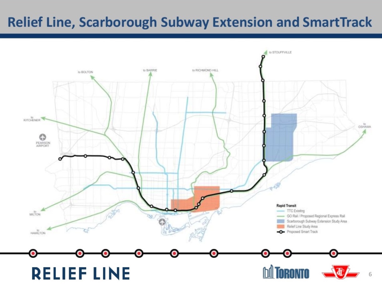
Slide 6: The context for the linked studies is the GO Regional Express Rail (RER) planning, the Scarborough Subway study, and the SmartTrack scheme plus, of course, the Relief Line. (Note the error on the map which includes GO service to Bolton as part of the RER.)
Slide 7: An important quote: “SmartTrack is expected to provide some relief to the Yonge Subway and may delay the need for the Relief Line. This needs to be assessed.” Yes, most definitely,and with a realistic view of the network function SmartTrack is likely to offer given constraints on its service level in the GO corridors. Too much hype from the mayoral campaign painted SmartTrack as a single project to solve all problems to the extent that the Relief line would not merely be deferred but wiped off of the map.
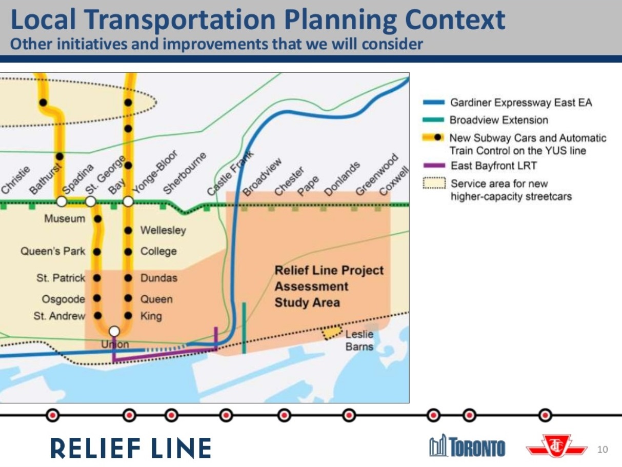
Slide 10: The local network context, the “study area”, embraces the core area from Dundas south to Union Station and a wide swath of the east end from the Don River to Coxwell. One part of the wider context is the question of the future role of the streetcar network with new, larger cars and with the demand effects of anticipated developments in new and existing residential areas. This has not received much attention in the larger context of the transit network, and it has only a small political constituency. Other related projects include the East Bayfront LRT (plus eventual extension into the Port Lands) and the Broadview Avenue extension. Because SmartTrack is very much “flavour of the day”, there are already attempts to downplay the role of the streetcar/LRT network with the false premise that the fine-grained service of a surface transit grid can somehow be replaced by a handful of rapid transit stations. This thinking has even infected the Relief Line study as we will see in a few slides.
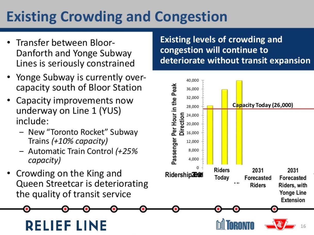
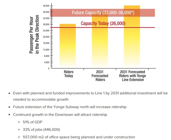
Slide 16: Both the City and TTC acknowledge that there are severe constraints at Bloor-Yonge Station. These arise not just from train capacity, but from the ability of the station platforms and circulation systems to handle the projected volume of passengers. The chart shows a current capacity of “26,000” although the line is actually drawn at the “27,000” mark. This reflects 26 trains at 1,000 riders each per hour, the line as it was when served by the T1 car fleet that has now shifted to the Bloor-Danforth line. The new Toronto Rocket (TR) trains and their 10% added capacity are already in place on Yonge, and the actual capacity of the line is just over 28,000 per hour (26 trains at 1,080 riders each). More can be stuffed in on a peak, crush load basis, but the line and stations cannot operate on a sustained basis at higher levels. Saying that there is a 10% future growth is misleading because the capacity is already in place.
Oddly, there is no reference to the expected 7-10% drop in Yonge line demand that will come when the Vaughan extension opens in 2016 or 2017.
A better chart can be found in the “Challenges” section of the website where the formatting is not distorted, and the 26k screenline is placed correctly. The notes below the chart cannot be ignored. Half of the City’s GDP is generated downtown, and one third of all jobs are located there. The pool of office space is growing and at a rate that dwarfs anything happening in the suburbs.
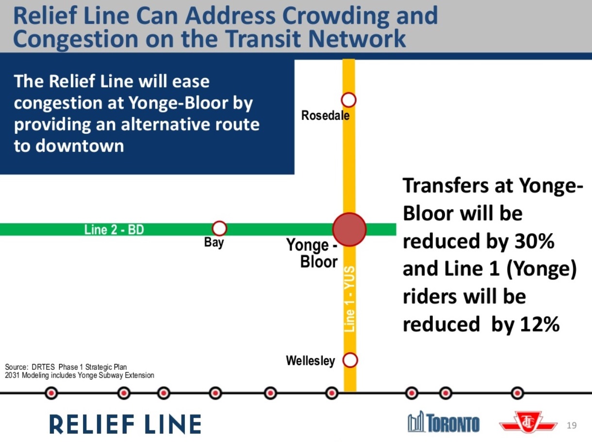
Slide 19 projects a 30% reduction in east to south transfer traffic at Bloor-Yonge and a 12% reduction in line demand south of Bloor
Automatic train control is expected to increase capacity by 25% with reduced headways, the time between trains, down from today’s 140 seconds to about 110 seconds (this is equivalent to a change from 26 to 32.5 trains/hour). That would take the route up to about 35,000 passengers per hour. The range cited in the presentation is 33-38K. Past TTC claims have shown capacities above 40K, but this would require heroic changes to the infrastructure and operations of the Yonge line that would be difficult and very expensive. Similarly, proposals for longer, 7-car trains, are a possibility when the next fleet is ordered in the mid 2020s, but there are physical constraints in many locations throughout the network based on the standard 75-foot x 6-car trainsets that have been used for decades. That would add a potential 10% to line capacity, provided that longer trains were technically and physically possible.
The DRL vs Yonge expansion debate has always been clouded by its focus on the high cost of any new downtown subway, but the cost of retrofitting the YUS to handle larger passenger volumes, and the exposure to greater effects from a single failure in the core area, are never mentioned. A proposed $1-billion expansion of platforms and circulation at Bloor-Yonge is never mentioned as an offset to the cost of the DRL, nor are the extra trains the YUS would need to operate at a higher capacity. To say that this skews the argument against a Relief Line is an understatement.
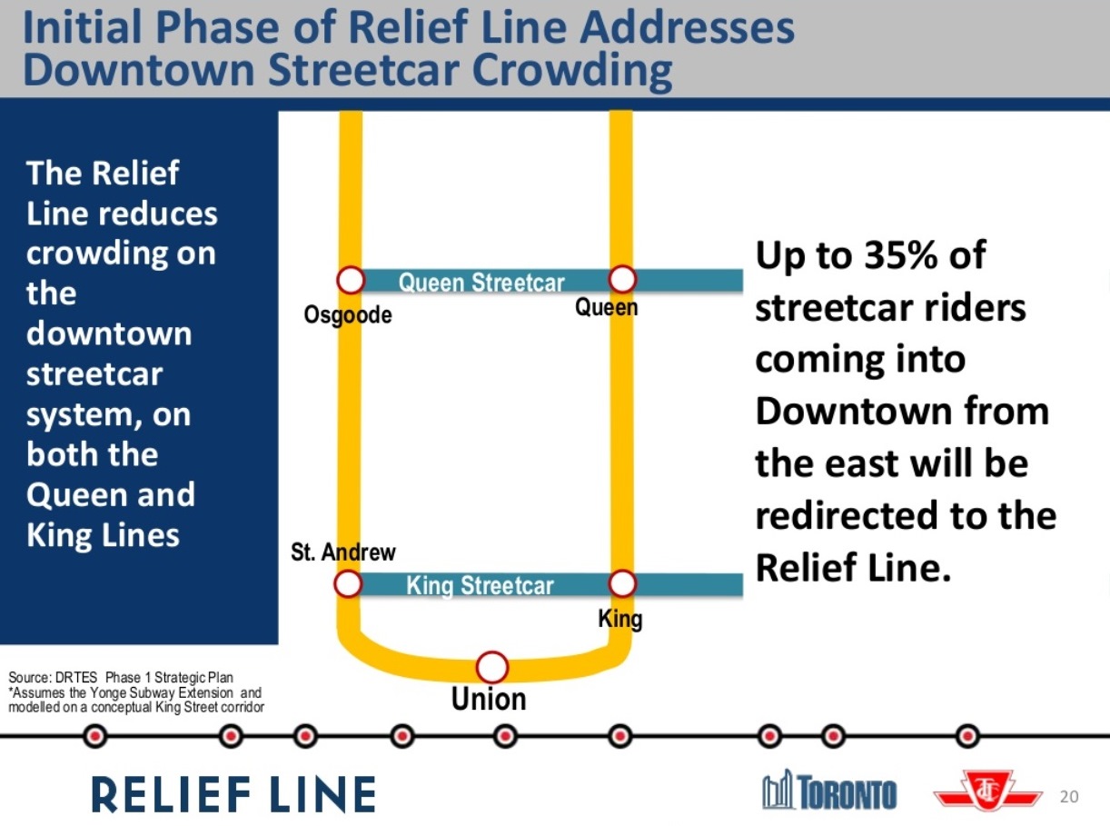
Slide 16 also claims that “crowding on the King and Queen streetcar [sic] is deteriorating [sic] the quality of transit service”. On Slide 20, we see a claim that a Relief Line could reduce streetcar demand by up to 35%. This is based on a King Street alignment for the Relief Line. This is nonsense on a few counts.
The Queen car to the Beach suffers from two basic problems:
First, there is not enough scheduled service – peak service runs every 5 minutes on a line that once had cars every 2 – and far too many of these cars never reach their destination at Neville Loop. The problem is not one of limited street capacity, but of service level and reliability. This can be fixed tomorrow, and a Relief subway is not required, only the will to operate more and better service.
Second, reduced demand implies that riders who have finally gotten on to a Queen car would choose to transfer to the Relief Line. If we we know anything from the Scarborough debates, it is that riders do not like to transfer, especially if this exposes them to the elements. The trip from south Riverdale to the core is relatively quick because there is little congestion on that part of the route. Any travel time saved on a DRL must be balanced against the extra transfer and wait time, plus access time from a downtown station.
As for the King car, it accumulates a substantial load at stops along its route down Broadview and west (eventually) along King. It does not leave Broadview Station packed with transfer trips from the subway. Moreover, if there is a capacity issue on King, it lies more to the west of the core, an area the Relief Line will not touch in its first stage, if ever.
What seems to be happening here is “mission creep” in an attempt to show how much the Relief Line could do. Such efforts might better be directed at talk of redevelopment on the DRL extensions, notably the benefit of heading north through Thorncliffe Park to Don Mills & Eglinton. Alas, that is outside of the study area and therefore ignored.
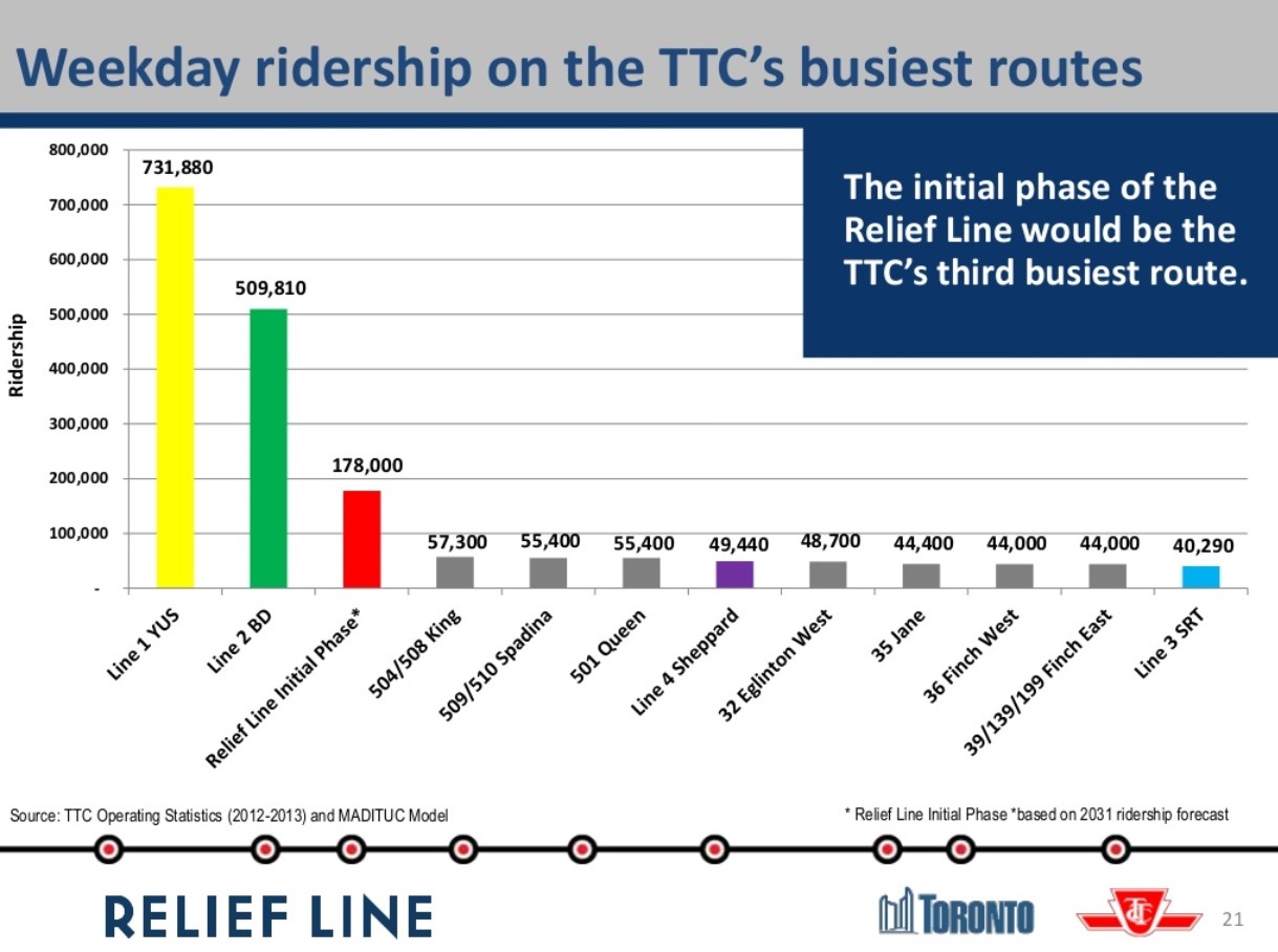
Slide 21 places the Relief Line in the context of other transit projects. With a daily 2031 ridership of 178,000, the line would outstrip by far all of the heavy surface routes, as well as the Sheppard Subway and Scarborough LRT. Although not shown here, I suspect that the Scarborough Subway and the eastern leg of SmartTrack would not fare as well as the DRL either.
The remainder of the presentation takes us into the station location issue I have already discussed above.
Advocacy for the Relief Line
The Relief Line has few friends and is beset by numerous accusations that it is somehow a sop to pampered downtowners rather than a much-needed network improvement so that there will actually be capacity for riders into the core from all over Toronto. [Note to commenters: don’t even think of trotting out those arguments again here. You have made your point in other threads, bogus though it is.]
“Relief” is always something for another day, or another proposal such as RER and SmartTrack. What we will almost certainly learn as the Metrolinx studies advance is that there is a limit to the demand the commuter rail network can handle, no matter what colour or logo one puts on the trains. There are physical limitations on individual corridors, and a combined limit on train and passenger volumes at Union Station. The rail corridors can divert traffic particularly from the outer 416 and inner 905 away from the subway lines, but the fundamental problem is that there will be more demand into the core than capacity. The Relief Line cannot be wished away by election rhetoric, and ignoring the eventual need for a new central subway route is folly. Sadly, Toronto Council and Queen’s Park are very good at “folly”.
What is badly needed is real advocacy for the DRL for its potential role in opening up capacity to the core and to areas beyond the core an expanded route can serve. This is an economic development issue that will benefit much of the City, not just a few blocks near King and Bay.
Picking ideal station locations on the first, truly “downtown” stage of the project perpetuates the idea that this is somehow a route to take folks from Riverdale to the business district when the Relief Line’s role should be much greater. Toronto needs to talk about that wider context and build a constituency for the Relief Line beyond Danforth and University Avenues.

Unfortunately there seems to be no clear way to get the extension of the study zone across the Don Valley into the terms of reference. I’m sure that if the MPP for Don Valley West were to indicate she wanted such a study extension, Metrolinx would act to facilitate that.
My view has always been to use the Pape Corridor, given that Pape is the economic centre of that part of The Danforth, a 4-lane commercial road with various trip generators including the Centennial College at Mortimer. The weakness of using Pape is in the crossing of the Don Valley and in building the connection with the Greenwood Yard which would lilely require a 1 track tunnel (or two track, just in case).
One thought I have had is that if the trains could be stored and maintained at a redesigned Bathurst Yard rebuilt with a new deck above the existing tracks, this could avoid the need to build that tunnel connection to Greenwood yard. Of course the yard redesign would be costly but it could be shared with the Metrolinx plan to build a new station at the yard.
In any case…we do not know where the DRL will go or where people want it to go. At this point the most we will know is which station locations are the most popular. This will determine whether the DRL will run across downtown Toronto via one of the east-west roads, or simply connect The Danforth to the St. Lawrence district. Once that is determined the rest of the network puzzle will start to fit together.
Cheers, Moaz
LikeLike
You want to put an elevated through one of the last remaining historic districts of York? I beg your pardon but are you high? Did you also miss the new park constructed on the west bank of the Don?
LikeLike
It is more than that – light rail offers far more flexibility in that LRTs can run undergound in a tunnel, they can run at grade mixed with traffic, at grade in their own right of way without being fenced in (no 3rd rail) or can be elevated. Corners can use a much tighter radius.
It is essentially impossible to run a subway line from Castle Frank south – which is one reason why the option of running any rapid transit line from Castle Frank was precluded, plus it has been taken for granted for 100 years that a line would run east of the Don River – like in the 1910 map that is exhibit 1-1 in the DRTES.
LikeLike
DRL Option 1 in the Report (pg 51) has a 2031 peak ridership of 11,700 and reduces the Yonge line by 4,700, plus another reduction on the University line by 1,000. I would expect the Castle Frank line to be similar – maybe even higher as it runs through a higher density area and many trips might actually end closer to this path through the Downtown than to Yonge.
LikeLike
Given the forecast ridership for the part of the line north of Eglinton, I think LRT needs to be the starting point. A Don Mills LRT would serve a large portion of this need, and would build ridership – perhaps to the point of creating a need to extend subway. I would agree that the stub from Danforth south does not offer enough connectivity. The new subway must at least reach into an area where you can run other rapid transit services to, ideally at both ends.
However, I would also like to see some way of running a much more frequent service in Richmond Hill to core (although could not run on CN tracks at the north end or in Union on a 5 minute headway), that would offer a frequent express service for the northern 416 and 905 to the core, and pull as many of the riders from Yonge who were core bound as possible. This somehow providing a service that would remove any desire to extend the Yonge subway to Richmond Hill, and reducing York Region load on extremely limited TTC resources.
LikeLike
My response:
Reducing heady on the YUS from 1:40 to 1:30 is equivalent to adding 4 trains per hour (36 to 40). If my express buses take an hour to make the trip from Pape to downtown and back, the same capacity improvement could be achieved with 90 articulated buses, which seems to me to be a very reasonable number, with an acquisition lead time of a couple of years.. (And yes there would be bus loading time issues, but they seem solvable to me.) So while you’re right that the prototype is on a Commodore Pet, you can achieve real benefits with a crap computer if you use it right. I’ve done the equivalent lots of time, with a lot of success.
You’re absolutely right that the DRL (or I would prefer “the Don Mills/Dundas West line”) is better and necessary – but why do we have to wait for decades to start to solve problems we could start to solve in a few years? Some incremental improvements could make a big difference in the near future. It’s less about efficiency and more about effectiveness in solving problems. And, yes, we should be building the Don Mills line in parallel.
Steve: 1:40 is a 100 second headway, and the TTC is unlikely to get below 110 (even that is a challenge). As for the 90 buses on a 60 minute trip time (headway of 40 seconds), I look forward to seeing them all try to load at Pape Station, never mind snaking around the corner where Pape runs into the rail corridor.
LikeLike
1. Carlaw/Dundas is a rapidly growing condo cluster.
2. Carlaw/Gerard has enormous potential for redevelopment on both sides of the rail corridor.
3. There’s a large high-density cluster along Cosburn from Broadview through to Pape through to Donlands that’s ripe for redevelopment and further intensification.
You’re proposing a line up Parliament. Cabbagetown consists of three heritage conservation districts where new development is forbidden under the Ontario Heritage Act.
LikeLike
The problem with the current study is that it is based on limiting the source of ridership by only building the portion from Danforth to core. The issue on Yonge extends well north Bloor, and ridership projections are very sensitive to this. I think that the extension to Eglinton forecast that is being used by the TTC does not reflect the increase that would come from the Eglinton LRT, let alone a Don Mills LRT.
I have seen previous ridership estimates higher than the ones being used for this study, and we cannot focus only on the low numbers used here, or just the fix for the southern portion of the Yonge line. I think one of the issues not being addressed in all these forecasts is the degree to which there is latent demand for the Yonge subway, and the degree of diversion that would occur on other bus lines further north that would help this issue. If you accept that 12,900 is your peak hour number, you are saying that the impact of the Eglinton LRT transfer is 1,200 riders at peak hour, and that there is no impact on the replace of bus with subway on ridership through the very dense area from Eglinton to Danforth. I would put to you that both of these assertions would turn out to be wrong. I would expect a substantial diversion from the Lawrence East Bus, as well as a substantial increase in ridership there, as riders will not have to get to Yonge .
Steve do you know what methodology was used in order to come up with these ridership estimates? Was there an allowance made for changes in surface transit trip times that would be involved, and the ridership that might be so induced?
Steve: The methodologies are never published including assumptions about land use and evolution of population, not to mention the logic behind trip assignments and the underlying network structure.
LikeLike
This would explain why there is so little discussions surrounding the issues of variance between forecasts, and direct questioning an discussion of the numbers themselves in a reasonable fashion. Route selection is obviously very sensitive to travel time, and a relatively small change in the network – right down to frequency of buses, could have a substantial impact on the choice of routes. While it explains a little of why, boy it leaves questions surrounding the estimates that are substantial.
Also, while the wide numbers of origins and destinations are available to the public, how much more resolved are the numbers the planners are working with?
LikeLike
Steve – so if YUS trains actually run even slower than I said, that means that the benefit of shaving 10 seconds off the spacing is even less … less than 3 trains an hour improvement going from 2:00 to 1:50 spacing, for instance …
And my calculations were off: 4 trains an hour is only 60 buses, and 3 would be only 45. And the beauty of using buses is that they don’t all have to go through Pape … you could do one bus every 2-4 minutes at Pape, and one bus every 3-5 minutes from Coxwell and/or Woodbine. And even put in dedicated bus routes that serve other potential DRL stops, e.g. Pape and Cosburn, Thorncliffe Park, even Eglinton and Don Mills or the DVP. The farther ones are tougher, I admit – would buses be able to use the DVP or would they need to go on city streets? Would there be enough demand to justify frequent service over long distances? In Montreal there used to be (maybe still is) very successful express bus service from Lachine to downtown – a handful of stops in Lachine, then hop on the expressway to downtown. The effective speed was similar to a subway, with far less cost. And you can run these routes only at rush hour if there’s not enough demand the rest of the day.
To me the bigger problem with buses is downtown. To make this practical you might need to do things like create bus priority lanes certain places, e. on Lakeshore downtown. And you would probably have to make the downtown bus stops on some of the routes be away from the very center of the core, where congestion is bad, unless you could put in HOV lanes downtown. This does reduce the attractiveness of the idea a little – but as the downtown core expands (especially southwards), this might actually be more convenient for some riders. Hence the idea of stopping places like Lakeshore and Bay by the pedestrian corridor rather than King and Bay.
Clearly buses are a stopgap solution, but since the DRL is likely to take 15 years at least to come to fruition, it’s a pretty big gap to fill, IMO.
The point is to create some temporary, flexible capacity — a hundred or two articulated buses should do it — and play around with routes to see how to best utilize it. This could give some insight into which DRL stops would be popular and how much they would be used, while temporarily easing the congestion on the Yonge line and at Bloor until the DRL could be built.
I’ve seen too many great projects fail because of analysis paralysis and lack of will – in my experience, if you do something quick and dirty and successful, it creates its own demand to make things more robust and permanent. In this case if this were done there would little debate about whether there is enough demand and where it would be – the only debate would be how much further the demand would increase with underground service.
LikeLike
Half of the complaints about the SRT are that it’s elevated. Equally important are the complaints about the Gardiner and Lakeshore.
Operationally, this is a very bad location for a station. It’s on a curve, the cross-streets are very close, so you’d have platforms over two, and the corridor is only 23.5m wide, whereas you need a minimum 5.2m clearance per track for straight sections, meaning you’d need to expropriate to the north between Logan and Pape. For comparison, the corridor at Danforth GO Station (Main St) is 45.5m wide. If you want a station built in the area, just south of Dundas makes more sense.
I think you’re being overly optimistic. The ‘high speed’ moving walkways average 7 kph (previous attempts at 15 kph resulted in nasuea, vomiting, and injuries). With 300m between Danforth GO Station and Main TTC Station, that’s 2.5 minutes, walking half the GO platform (160m) is another 2 minutes, at 15 minute headways (8 Lakeshore East and 4 Stouffville, but only 4 stop at Danforth) that’s another 7.5 minutes. We are already at 12 minutes total without looking at station access times.
Finally, this whole issue is premised on diverting TTC passengers to GO, whereas GO is looking to divert passengers onto the TTC. Specifically, with 15-minute headways in the AM peak, there might be 3K-5K spare capacity with that much again if you reach crush capacity.
Ignoring the uber-claims of ST and relying on Metrolinx forecasts of the GO network, assuming Union Station capacity relief, Lakeshore East hits capacity (21.6K pax/h) by 2033 with 5 minute headways. In the meantime the Yonge line hits capacity (38K pax/h) in 2035. Personally, I think these numbers are optimistic due to latent demand.
Corner radii are solely a matter of design speed and axle spacing. Running in mixed traffic hardly constitutes a LRT, but a glorified streetcar. Once you move away from a dedicated ROW, you run into all sorts of secondary issues, such as service reliability. Overhead catenary versus third rail isn’t an exclusive LRT benefit, similarly subways can be elevated, such as we have on the Bloor line over the Don Valley.
Steve: Or at Keele Station or the bridges at the 401 on the Spadina line where the structure is subway-specific.
Just because there is a continuation of reasons doesn’t mean the assumption has been taken for granted. Everytime the can of worms is opened, eastside alignments are considered, but westside alignments are preferable for network connectivity. In 1910, part of the benefit was to provide water and electricity to East Toronto. Castle Frank is a bad connection because it provides less Yonge relief, regardless of the difficulty of construction.
Yes, the DRTES 2012 study does have that number on that page. On page 53, they also have 24,400 boardings and 24,500 alightings, which would put the number at a minimum of 12,225. This inconsistancy makes me trust other reports more.
Steve: The discrepancy comes from the fact that people do not travel from one end of the line to the other, but get on and off in between, and travel in both directions. It is possible to have a peak load considerably less than the total boarding count.
I suggest you look at page 53 and note that the vast majority of riders are transfers, not locals, so every 1% increase in local riders would be offset by only a 0.42% decrease in transfers.
Given the choice between an 18 minute subway trip (Bloor-Yonge) and a 30 minute bus trip, there isn’t going to be many people choosing the option that’s twice as slow. In fact, many people would probably also chose private cars over the TTC, since they’d be the same speed. The theoretical capacity of 40 second headways would also be reduced because of signal timing. If 90 second cycle lengths are typical, then on average you’ll have 2 or 3 buses arriving at the same stop within a 10 second period and then a gap of 80 seconds until the next platoon.
Again, you ignore the issue of garage space and construction costs for such a scheme. I’m not against having more buses in the system, or parallel surface transport, but you can’t ignore the lead time to design and build such buildings.
LikeLiked by 2 people
Why Sherbourne though? Do you live there? To save $50 million on 2km of tunnel?
What’s not talked about often is the capacity of the Danforth line. It’s pretty close to the maximum right now so it will need relief in the near future. Arbitrarily moving the line west to satisfy your napkin drawing would compromise any Danforth relief function, not even to say anything about the feasibility of actually constructing an interchange at Castle Frank.
From a network perspective I think it’s important to keep the line from Pape and eastwards. The crossovers on the central part of the Bloor-Danforth line are at St. George and Chester. If the central part of the line were to be shut down for any reason (emergency, maintenance), any DRL that’s west of Chester would not connect with the Danforth east line and there would be no alternative path into and out of downtown from the east.
LikeLike
With the cost overruns on the Spadina subway extension, will they re-estimate the Scarborough subway as part of a lessons learned exercise?
Steve: They have yet to admit that the Spadina line is over budget, let alone what factors created the situation. One of them was that the TTC has claimed for months if not years that there was no budget problem, when construction delays and inflation, if nothing else, were pushing up the cost. They ate through all of their contingency allowances and then some, and station construction costs ballooned due to unexpected conditions. (Leslie Barns is only a small version of the same problem.) See Transit Toronto’s history of the Spadina extension for station by station details (scroll down to near the end).
There is something severely wrong with the whole “transit assessment” process that defers so much of the detailed investigation of site conditions to post-approval to the extent that major factors that could bear on route selection and budgeting are not known while basic decisions are made about projects.
LikeLike
No – my preferred option is an underground LRT from Castle Frank south – mostly above ground going north. I am also proposing that at the very least we should run the current streetcar tracks from Carlton & Parliament up to Castle Frank with an underground loop/station there. Look at this map and notice how there is so little north south transit east of Yonge (granted buses are not shown), with most of Parliament being unused … there is St James Town, Regent Park, the West Donlands, the east side (the Kings) and all the stuff on the Harbour – so we could have a surface line running down to the Harbourfront LRT mirroring the Spadina LRT, except it would not be in its own right of way.
There is also the issue of redundancy – in this city, we seem to assume that everything will always run perfectly and make no allowances for emergencies and service interruptions. What happens when the Yonge line is closed – all we can do is get out the buses and have the Spadina line pick up some of the slack – but there is no equivalent on the east side.
Steve: Your own comment describes “Phase 1” as:
You want a redundancy to Yonge on the east side similar to University/Spadina on the west. That’s what a DRL to Eglinton does.
We are intensifying the Core – but there are no major transit improvements planned north of King between Bathurst and the Don River under any scenario, beyond reducing headways etc. on the YUS – yet there is a lot of new development planned or being built on Church, Jarvis etc. as well as the intensification of Regent Park.
Steve: Your omission of the bus routes is telling, but more to the point as others here have noted the demand pattern is east-west, not north-south in the area east of downtown and south of Bloor-Danforth. As for transit improvements, the city is looking at what can be done to increase east-west capacity on the streetcar network where the biggest problem is that we have allowed the fleet and service levels to decline substantially over the past two decades.
Leo: Carlaw Dundas is not that big and nearly all of the former industrial sites will be developed into Condos within a few years – maybe there will be a Smarttrack. At Gerrard there are the 2 commercial sites (WalMart) BUT there will be a Smart-Track GO station there (also serving Carlaw condos mentioned above) – so it will have Transit and likely be intensified long before a DRL get built. There are no “Avenues” in the area, and Queen is becoming an HCD. Yes, much of Parliament St is an HCD and I do not anticipate much intensification on Parlianent itself, but an underground line can bend and go under part of Sherbourne and even Jarvis – only a surface line has to stick to Parliament. BTW, HCDs can be developed, but it is harder to get OMB approval as HCD is the most powerful planning tool, but it is not airtight,particularly if a building is not itself of heritage value. Queen West is an HCD but the GAP store is being redeveloped in ways that break some of the HCD rules.
The province still hasn’t figured out how to pay for Let’s Move, we are having tax increases for the Scarborough Subway (instead of the cheaper and better routed LRT), the DRL is a long way off and the idea of a DRL running all the way up to Finch etc. is absurd to be thinking about given all the other lines that will likely have to happen first.
It is easy to have big unrealistic dreams about a city criss-crossed with transit lines. Given SmartTrack and GO upgrades/connections at Main etc., it makes little sense to build a subway/LRT line that will have all of its stations east of the DVP within 300 metres or less of SmartTrack – essentially redundant stations/capacity for those local areas – what I propose is shorter by 2km, doesn’t need a tunnel under the Don River (they had a lot of trouble building the berm because it was all marshland) and will add extra capacity in the Downtown where more development will bring more cars and trucks, slowing down the streetcars even more over time.
Steve: As already pointed out, some of the ST station location proposals have severe problems with available right-of-way including Gerrard Square. You are putting too much faith in ST doing all of the work so that your LRT plan can ignore areas that ST may not actually serve as well as claimed.
LikeLike
Underground LRT is not that much less expensive that HRT. Eglinton does it because the line is to run on a surface right of way in the middle of the street. The tunneling is actually slightly more expensive because a larger diameter is required for the overhead. The underground stations are being built to 400′ length instead of 500′ for HRT so the saving on station costs is not 20% because both stations need utilities and surface access. If you are going to build a completely private right of way then the minimal cost saving between LRT and HRT is not worth it. Study a topographical map of you route north and see where it would go. Elevations are important. Maps only show 2 dimensions and you need all 3.
LikeLike
Because this is ***ing Toronto, I expect to be reading about a new “Downtown Relief Line Study” 10 years from now. Oh, and a new GO Transit electrification study, too. And a study on buying enough streetcars to run existing operations, because there won’t be enough.
Meanwhile, suburbanites will somehow manage to get full funding for the “Toronto Zoo Subway Extension”, because “every world-class city has a subway to the Zoo”.
Too pessimistic?
Steve: There is already a subway to the Zoo at City Hall — two stops!
LikeLike
I live in the Beach but own another place I rent out by the AGO – actually the DRL is closer to my home than my my proposal … but driving downtown is impossible and will get worse unless we start looking at improving transit within the core for the people living there, and not just to focus on how to bring in commuters from long distances to King and Bay.
Money is important – the newspaper story today indicates the extension to Vaughan is now another $400 million over budget – 2.9 billion for 8.6km – $337 million per km through suburbia – tunneling in the old inner-city is tougher and more expensive – tunneling is far more expensive than $50 million for 2km, be it LRT or subway.
So I think it will be more than $50 million saved, because I am proposing
1 LRT/streetcar instead of Heavy Rail
2. There is no tunneling under the Don River
3. No need to build a bridge over Rosedale valley – it exists already but cannot be used for subways, only LRT, given the current subway alignment
4. The first phase of doing the underground loop and connecting Castle Frank to the streetcar network could probably be done for $100-200 million (I recall the underground loop at Spadina was $75 million) so the project can be done in smaller increments, meaning some improvement/diversion of people from BD Line 2 sooner.
5. For any future expansion to the north, if the DRL is subway, it would need to be completely underground save for crossing the Don Valley – but crossing the Don Valley likely means a massive new bridge. My proposal would be mostly at or above grade north of Bloor.
6. To shorten the line even more, there is the possibility or using the roughed-in station at Queen and Yonge (instead of King or Front St) for more savings – this station is designed only for streetcars and not heavy rail.
For a minute, let’s stop thinking about commuters and ask where a new line in off-peak hours also makes sense. Riverdale will get SmartTrack/GO and running the DRL so close to it is pointless and a waste of money to serve one low density area with 2 new lines when not even one is barely needed to serve the local needs and expected growth, while meanwhile the Downtown population is growing in line with the OP.
We can’t intensify every part of the city at once – the city has been, and is supposed to grow by about 30,000 people per year – about 16,000 units of housing (20% of the GTA’s population growth), but look at what development will occur in the next 30 years:
Downtown under the OP
East Bayfront
The Portlands
The Kings
The 4 Centres under the OP (Yonge/Eglinton, but Scarborough Town Centre in particular to pay for the subway)
Along major transit lines (Sheppard, Eglinton, Finch)
Local projects like 6 Points, Don Mills Centre, Honest Ed’s, brownfield sites, etc
The Avenues (particularly in the suburbs to replace strip malls on Lawrence – development on the streetcars makes little sense if the streetcars are at capacity or we lose more heritage areas)
Downsview (30-45,000 people?)
About the only place the city is saying no to development is open space or in low-rise residential areas, like most of Riverdale.
We can’t be developing/approving development in ALL these places at once in a willy-nilly fashion, and then adding in areas of new intensification to boot. To pay for new development, the city should be prioritising/pushing development to go first to areas with existing or planned transit (Eglinton, Sheppard) and not running transit lines through areas where little or new intensification will occur, particularly if those areas will be getting better transit because of SmartTrack.
Remember how everybody was so eager for the SkyDome – then it became a white elephant. Or the Sheppard subway (which was supposed to pay for itself with new development, which didn’t happen for 25 years). Or how we have flip-flopped from subways to LRTs and now back again – I think that if SmartTrack goes ahead and then it comes time to build th eDRL, it will become apparent that it won’t add many net new riders south of Danforth or cut times because that is what SmartTrack will have already done.
LikeLike
Malcolm:
I assume that you sometimes get on the subway at Finch. I have done it a couple of times towards the end of the a.m. rush and it is quite full. It is even worse at Sheppard when a train has come in. From then on south it is extremely full and difficult to get on the trains south of there. Perhaps you could help enlighten BTGraff about the loads carried by the Yonge line North of Bloor. The Don Mills Relief line has to go at least as far as Eglinton to be of any real benefit to try and get loading off Yonge before it gets to Bloor and to get riding off the Danforth line.
York region wants to overload Yonge with an extension to Richmond Hill. In order to keep service on Yonge viable there has to be a north south line east of or along Don Mills eventually farther north than Eglinton. A piddling LRT line up Parliament would serve no useful purpose except to give another source of argument to no street cars and subways, subways, subways crowd. I am entirely in favour of LRT lines but in places that would be useful.
Since BTGraff seems to be in favour of small dimension cars and elevated I suggest he research or ride the Chicago L. It has PCC cars running in trains up to 8 cars long and rides over downtown streets on an elevated. It is a great view for a rider but not for someone whose bedroom is 6m away. It has level crossing with third rail across city streets but not as many as it used to. Elevated railways are not nice futuristic rides like Disney World would have you believe. They are eyesores in most spots.
Matthew Phillips seems to have access to more recent data and alignment numbers that most of the rest of us. Unless you believe that he is making all this data up BTGraff, and I don’t, I suggest you pay some attention to what he says along with others on this site.
LikeLike
Well depends on how you account for it. If you choose to stick strictly to the construction dollars then ok fine you have a point. However, if you want to talk about what is required to get it done then I beg to differ. If we had gone with underground LRT, we likely could have gotten it through the process and by the no more subway for downtown lobby quite some time ago. Robert – we need to build what is required – however it is becoming increasingly clear- calling it subway costs us the thing we have even less of than money – time. So please can we just call it LRT, I don’t care if the cars are 3 meters wide and use a third rail.
LikeLike
I have a degree in architecture so I do think in 3D and consider topography …
But I have been intrigued by lines like how west of Roncesvalles the Queen car can run in its own ROW and then it can run in traffic in the core. When the City was looking at the SRT issue and was deciding between Subway, the new longer Bombardier vehicles (ICTS replacement – Innovia? the ones which can’t handle the curves) or using streetcars, I thought that using streetcars was best because they could run elevated and then east of Scarborough Town Centre could run at grade and maybe even swing north and then run west on Sheppard (from Markham) instead of people needing to transfer – apart from cost savings by eliminating once type of vehicle (maintenance facilities, parts and training specific to Innovia or something other than streetcars, buses or subways). Frankly, I even consdiered an LRT running down the middle of Kennedy Road as being a far more “Urban/Walkable) solution -though slower of course (Scarborough deserves a REAL Downtown, not a shopping mall… either on Eglinton or Kennedy are the best choices, but Eglinton is all big box, at least for now).
Steve: You have caught up with those of us who have advocated just this sort of LRT with all its flexibility of implementation for decades.
Which is the problem – development and transit patterns responding to the lack of transit, not potential need. I think the result is that the east side has been an area of poverty and economic problems – not just because of Regent Park, Moss Park etc. but it lacked the vitality of the west side (Kensington, Little Italy).
From Beverly and Dundas there is amazing transit – east west or north south – not so much at say Dundas and Sherbourne or Parliament. I looked at buying houses/condo in the east side of the core, but found the road pattern and lack of transit north-south to be an issue. Also, I used to work at Church and Bloor and was frustrated that there was no station to the east until Sherbourne – Jarvis is so wide that I wondered if an LRT down the middle was possible and to build a new subway station at Jarvis – and then to continue north somehow to Mt. Pleasant. I lived most of my life in Don Mills and so frequently drove up Rosedale Valley Rd, Bayview, Jarvis etc. – taking transit from Lawrence and Leslie was difficult and there are no other choices for getting downtown other than going to the Yonge Subway or driving – the Don Mills bus being slow and going too far east. So I have often contemplated ways of making a transit line to Don Mills or other things between Yonge and Victoria Park for commuters like I was.
Steve: I beg your pardon, but the transit service at Beverley and Dundas is exactly the same as at Dundas and Sherbourne as far as east-west travel goes. To the east there are north south bus routes, not that they are extremely frequent, but at Beverley, one must walk west to Spadina or east to University for north-south service.
Travel in Toronto is predominantly east west for the simple reason that the city is shaped that way, and there are barriers to through north-south service in many places.
Build a new station at Jarvis and Bloor? Aside from needing to break into a deep bore tunnel, you would be a stone’s throw from Sherbourne Station.
What? If Yonge were closed in an emergency, a streetcar/LRT line down Parliament would do far better at picking up people from the streetcar lines on Carlton, Dundas, Queen and King and taking them up to BD Line 2 than forcing people to go farther east of the DVP to Broadview or Pape – particularly because the College/Carlton line jogs south at Parliament and Dundas tracks end, so it turns and goes up to Broadview and will not go as far as the DRL.
Steve: People will not divert off of the Yonge line onto east west streetcars just to reach a Parliament/Drl line for the simple reason that there is nowhere near enough capacity on those routes to absorb the subway demand.
I still do not know why this would be true if it is not also true of Broadview station too? There is little difference. The idea is to give people the option to transfer before they reach Yonge. If making the transfer farther east is so great – then why not run the DRL from Main Station, which also connects with GO/SmartTrack, then under Kingston Road and Eastern?
If nothing else, doing the loop alone at Castle Frank and connecting it to the streetcar lines means that if Yonge/University is closed, some streetcars could be put in place to run down Spadina, the east west in the Core, then turned to go up Parliament – much shorter than using Broadview or going to Pape/DRL.
Steve: Once more with feeling — the DRL is NOT going to Broadview. At the westernmost point it will go to Pape. A DRL would be a Yonge bypass by picking people up right in the core where it is running east-west and taking them up the Don Mills corridor. The most likely crossing point for the Danforth subway is Pape or Donlands.
You also seem to have no sense of the limited value of a Main Station connection, nor of the near impossibility of running a frequent service down Main to Kingston Road.
I am tired of discussing this streetcar fantasy.
LikeLike
My suggestion as to where to put a DRL is to put it into the 1970s but that would require a working TARDIS which, unfortunately, I do not have.
LikeLike
I’m not sure why this is so absurd. Assuming you would close the road down during tunneling, the construction is no more invasive. The roadway is not greatly impinged on once its complete. Elevated subways exist in Philadelphia, Chicago, New York, Los Angeles. I’m sure there are others. In Philly there are even mainline tracks running over major arteries (see South 25th Street). Not pretty in some eyes I’m sure, but esthetics can be improved on. Oh well, just a thought.
Steve: Actually, elevateds take space for their support and access structure especially at stations. It’s not just a question of building them. Also, they blight the streets below especially if these are narrow. Examples in Chicago, NYC and Philadelpia are from construction a century ago when this type of intrusion was tolerated. Los Angeles? Where?
I figured as much. But are those complaints by nearby residents about the SRT or riders? As I rider I would prefer an above ground service.
Steve: Actually there are regular complaints about noise on the at-grade portion of the SRT. The western part of the el runs through an industrial district, and to the east, buildings are not immediately adjacent to the structure. In particular, it does not run directly above city streets hemmed in by buildings. Apples and oranges.
LikeLike
I am curious to see how the project can possibly be justified given the Neptis Foundation’s report on the DRL and its conclusion that the project had an exceedingly negative Net Present Value, and was fundamentally not in the public’s best interest. The lack of transparency regarding the methodologies raises serious concerns, and significant doubt about the DRL’s viability.
Steve: And you believe the Neptis report? They too have their biases, and their work derives from a group would prefer to downplay the DRL’s viability and usefulness.
LikeLike
The SRT has elevated sections where it runs through industrial areas – which makes sense. My proposal would have elevate sections in the Don Valley rather than being all at gradeor being underground – cheaper plus the area is prone to flooding. I was in favourof running a lot of LRT lines in hydro corridors (i still thik the Finch LRT should run at or above grade from Seneca/DVP to York U) so it might need to be elevated where it crosses major streets.
I would also note that like a lot of people, I am not a fan of LRTs running down the middle of major streets like Spadina or St. Clair – making turns for drivers difficult and not having to share the space with things like school buses taxis and emergency vehicles.
And there is the issue of how to pay the operating expenses, since transit doesn’t pay for the operating costs, yet alone the operating costs, and so we need to be careful about overbuilding and have white elephants with far more capacity than is needed.
1800 Boardings at Don Mills and Eglinton is not going to solve future problems with the Yonge Subway north of Bloor… mybe we need to get more people to switch to using GO at Leslie and Sheppard, or run the Sheppard subway over to Allen Rd – maybe the Crosstown will see more people staying on and taking University/Spadina to go southbound. The DRL might be LRT not HRT – in which case the Castle Frank Route is actually better for bringing people into the Core since it is shorter and faster.
I am not sure where Matthew is getting his numbers from… what sources or where to see them for myself.
Steve: I have stopped editing your comments beyond a bit of formatting.
LikeLike
There’s very little terminal space and time for more intensive bus service at most of the Danforth stations. Perhaps you intend for people to board on the street?
LikeLike
There is another solution – stop population growth so things don’t get worse and we have 20-30 years to catch up with demand … if supply of transit can’t keep up with demand to stop congestion from getting worse, then freeze the demand for transportation where it is now.
Read Philip Cafaro and realise that on a per capita basis, Canada takes in twice the number of immigrants per capita as the US (280,000 for 34 million here vs 1.09 million for 320 million there), and notice that our unemployment rate is now higher than theirs (Huffington Post), and the quality of jobs is going down according to a study in the Financial Post today.
We have a surplus of labour, not a shortage, and the issue of an aging population is over-played or premature. Stagnant wages and the increase in poverty – this city was more livable in 1990.
Steve: Over the past half-century, it has proven almost impossible simply to control growth and development, let alone halt it. This “solution” is completely a non-starter.
LikeLike
Robert are you referring to the fact that enough load boards at Finch to fill the line for hours. Nearly 100 k riders per day at just this station, or worse they come heavily in the peak hours? Or are you referring to the fact that 76k more join at Sheppard? Or that these stations each attract more riders Kennedy and the lesser of the 2 more than 3 times Warden? Perhaps you are referring to the notion that just these 2 stations would represent respectable ridership for a subway line? Sorry Robert I am not sure I know to what you are referring – oh sorry perhaps it is the solid wall of people that flow from the buses at Finch to board the subway? You know Robert – I do not feel I have really addressed the issue – except that perhaps we should talk about the Yonge extension proposals that would have the current capacity of Yonge fully loaded at Finch (26k or so as I recall with the extra load south bound at Finch at peak hour). Did I mention that Eglinton also sees fairly substantial use, and a decent amount of that boarding (3 times Warden as well)- with more to come with LRT – heads south. Do we need to discuss the fact that the Sheppard load pulses with that subway, and cause additional issues with loading that will only get worse overtime?
Sorry did I mention how terrified I was of a Yonge extension to Richmond Hill ?
LikeLike
I have never seen a survey or other data to confirm this. What people really care about is speed and reliability. The evidence shows that people do not care at all if transit is elevated. The most popular part of the SRT route is between Brimley and McCowan, where all the development occurred after the elevated line was in. The EA for the SRT to Malvern considered portions on-street and locals pushed to have it grade-separated, including elevated. On a smaller scale, the EA had the line on-street at Black Creek and Weston residents pushed to have it elevated (actually a bridge and some approach elevated track). When the Ford-McGuinty Eglinton-Scarborough Crosstown was agreed to, there were no complaints about the elevated portions – the only complaint was the cost.
I would say that evidence shows a strong opposition to on-street transit, but virtually no opposition to elevated transit. I have not heard anyone compare the 6 to 8 lane (25m to 30m) wide Gardiner Expressway to the SRT, which is maybe 7m wide. The Gardiner was also built to older standards and receives road salt, making it completely uncomparable to modern (even built in the 1980’s) elevated transit. All this being said, I think most streets where traditional DRL routes would pass through downtown would probably not be conducive to elevated transit due to the narrower streets and existing buildings.
LikeLike
You have basically answered the question. I was referring to the large number of people getting on at Finch and Sheppard and the fact that there are no seats when the trains leave Finch. Trying to add more riders to the line south of there will be almost impossible. Building more east west capacity that requires a transfer to Yonge is a non starter.
LikeLike
Steve – if the TTC can figure out that DRL would be the 3rd busiest route – where the heck is the Eglinton Crosstown and why is it not on that slide? Politics says that that is a Metrolinx project so we’ll just overlook that. This sucks. The whole ‘web’ of lines will increase transit use exponentially. The planners are daft. And the politicians who expect it all to ‘pay’ are dummer still.
LikeLike
Gold Line.
Steve: Ah yes, that one. Note that it is on a wide street with low buildings. The photo is taken from at least four lanes away from the structure. Not possible on downtown streets. This is a classic example of misrepresenting the look and feel of an “elevated” much like the kind of crap we had from the Ontario Transit Development Corporation when they were trying to sell “Go Urban”.
While we are on the subject of elevateds, look at Chinatown Station on the Gold Line. Note the size of the roadway, and the amount of space consumed by the station structure. Now imagine this at, say, Carlton and Parliament.
The downfall of many schemes to use aerial structures is that people forget how much space a station requires. It can work in an open area surrounded by parking lots and wide roads, or in an integrated development with a new bulding, but not within a dense existing neighbourhood.
LikeLike
@steve, @giancarlo On the amount of space that an elevated station has to take, here’s another perspective from across the pond. Higashi-Mukojima train station (on the Tobu Skytree Line in Sumida, Tokyo) has elevated platforms and the station ticket counter at street level. Sumida is (for lack of a better term) a suburb of Tokyo, so although the density there is higher than we would typically have in Toronto, it’s considered considerably lower density for Tokyo.
To get an idea of the footprint of the station and the elevated platform, here’s a
Google Maps link for someone facing West looking into the station. Some of the space under the elevated tracks has been leveraged for different uses; one is a museum (NB train cars if you move South) or pharmacy and grocery store (turn right, ‘Smile every day!’ is the pharmacy, ‘Aeon’ further up is the grocery store, what looks like a hair salon between the two).
I’ve no sense if this is feasible here, for building code etc. considerations.
Steve: The important points here are that the “station” and the train’s elevated structure in effect form one side of the street in place of a row of buildings whose mass the elevated approximates. Mapping this onto a Toronto street would involve substantial demolition.
Just to be clear to all readers, I know there are places where elevated structures can and do work, but when someone talks about placing one on an existing four-lane street downtown in Toronto, this is not a match to the “good” examples, rather to something like The Loop in Chicago.
LikeLike
Steve Writes
This is a classic example of misrepresenting the look and feel of an “elevated” much like the kind of crap we had from the Ontario Transit Development Corporation when they were trying to sell “Go Urban”.
In what way? You can make it “look and feel” any way you want. I wouldn’t try and sell the LA Metro esthetic to Toronto. Different city, different amount of space. Elevated railways on the East coast / Midwest are much more compact. Compare Chinatown station with Quincy Station in Chicago. You could fit that at Carlton/Parliament.
It also has quite a stylish interior. How’s that for look and feel?
Steve: I am not referring to the quaint interior, but to the effect on the street below of the elevated above. Also, you are showing the station in profile, not from the view on the street under the elevated structure. Yes it would fit at Carlton and Parliament, but would destroy the street under it in the process.
Here is the view underneath the station. Just the sort of thing everyone wants as an addition to their neighbourhood.
LikeLike
Steve: And you believe the Neptis report? They too have their biases, and their work derives from a group would prefer to downplay the DRL’s viability and usefulness.
I believe that major capital projects should be justified with the use of transparent internationally respected methodological standards. As of yet I have not seen any acceptable justification for the DRL that would justify the capital outlays necessary to construct it.
Although I strongly agree that the downtown core requires improved transit carrying capacity to build economies of scale and economic competitiveness, the current approach has serious problems with its full cost accounting and general strategic management that would integrate the subway into larger primary societal goals.
Steve: I think that you will find that no subway built in Toronto or proposed will achieve “internationally respected” standards. The DRL has the highest projected demand of any of the lines on the drawing boards or under construction.
Tell me how you will get all of the riders into downtown if we don’t build it. And, no, you cannot cite the outrageous claims made for SmartTrack which depend on a service level, capacity and speed that cannot in fact be achieved. Respected standards include honesty, something missing by bucketloads from the SmartTrack proposal.
LikeLike
Here we have come to the core of the problem. The process is fundamentally flawed and unable to provide any guidance on what should or should not be built. What is worse is that the failure to adopt internationally respected standards for project evaluation has created results that have resulted in political polarization and political paralysis.
LikeLike
The problem with this is that we do not have the labour in the right skill sets. This is much like saying we have surplus buses – see they do not run from 2:30 am to 4:30 am so we have bus hours left over. The purpose of using immigration to fill the labour force is in theory to fill skill shortages. However, I would be the first to say we use this option poorly.
LikeLike
I seem to remember some streets that were not very inviting in Chicago. This sort of application anywhere the line would normally attract ridership, would mean that the area was subjected to being a very uncomfortable host to a service that was not targeted primarily to serve them. I think that overhead would work reasonably well in 3+ chain roadways, but that would beg the question as to why bother. Thanks for the visual reminder Steve.
LikeLike
I still believe that we should do our very best to collect the data we can on the origins and destinations for the most knowable trips. To me this would mean that we need to get the information from employers with regards to the location of residence of their employees, and schools of their students. If this data was collected on a reasonably detailed basis, you could actually begin to do some very real network modelling, that would include the impact of changes in the bus routes. If you used trip time comparisons for each potential line, you could actually get a pretty good idea of likely ridership, and to what degree you should alter the bus routes post construction.
However, there will be no such thing as a perfect study, or perfect network. There comes a point where we need to move based on the data available, and a reasonable estimate of the impact of the changes. Which current bus routes will direct the vast majority of their ridership to new lines, and what ridership does that imply. What degree of induced demand beyond this would be reasonable? The existing bus ridership is a known, the existing population densities are a known. The existing surface road structure is known. Adding more resolved information with regards to origins and destinations will make it easier to justify a line, however, I would be very surprised if the current numbers for transfers for BDL are not reasonable. Where I think the current numbers are likely incorrect, is what Matthew Phillips is talking about in terms of line loading – the implied numbers for the area north of Danforth if the line extended there are not credible, nor consistent with studies regarding line use for a Don Mills LRT (or in my mind even current Don Mills and Lawrence bus route ridership).
However, the bottom line is, given how full the Yonge line is now at Eglinton, I would be very surprised if all core bound riders from the Crosstown east of that point, and all Lawrence Bus riders core bound would not use a DRL to get to the core.
I would like to get the data with regards to origins from employers – as this would be extremely useful for all transit planning and modelling across the region. However, if we cannot arrange this we do have other information that does point to likely answers, and we have a terribly overloaded network, that requires much improved connectivity. What I find hardest to take, are those who believe that Eglinton will grow to full subway load on the east side, but still we have no need of an alternate line (not Yonge) to connect it to the core.
LikeLike
So basically, this boils down to improved service on the 143 Downtown Express and various streetcar routes (501-503, 506), plus north-south bus service on a few routes like 22 and 92. I would be over the moon for a dedicated ROW on Queen or King. I’m not against any part of these suggestions in general, but for their specific application, they miss the mark. The lion’s share of ridership comes is to come from subway riders. Generally speaking, riders are willing to switch from subway to subway because they are equal reliability, and offer the opportunity to sit down. Many less would be willing to switch subway to bus, because of the inconveniences associated with surface travel.
I agree we need to push the envelope on the status quo, but the key factor is garage space. This plan would be a 5% increase in the size of the TTC bus fleet. McNicoll Bus Garage, which is currently in progress will hold 250 buses, will take 8 years between conceptual design and completion of construction, and will cost $181M plus design fees.
Ah, the villiany of ST strikes again. ST will make it rain gold, so we don’t have to worry about people commuting to work, they’ll just stay home and collect the manna from heaven.
Let’s look at your points of cost savings:
1. Flexity streetcars have a unit cost of $6.0M each with 251 crush load passengers (70 seats) for a cost of $23,826.26 per passenger. The T1 subway cars cost $3.0M each with 250 crush load passengers (66 seats) for a cost of $12,136.75 per passenger. So this cost saving is misleading.
2. A decision on tunneling or bridging over the Don River hasn’t been made yet, but in general bridges are almost always cheaper, so this point is moot, especially as it’s covered again under #5.
3. A bridge over the Rosedale valley is only needed if you have a DRL alignment west of the Don. The better DRL subway alignments are on the east side, so this point is moot.
4. Until the line has a destination ridership will be minimal. This is beside the point in that it’s not a cost savings. In fact, as operations don’t produce net revenue, opening sooner means a higher cost.
5. This point is a non-sequitur. If you have to cross the Don Valley to expand north, then the cost for a bridge has only been delayed to “Phase 2” instead of actually eliminated. The cost of tunnel versus surface building is significant, but brings it back to the basic premise.
6. Lower Queen has no space for passing tracks nor loops, an underpass exists where the westbound platform used to be, the wall required shoring due to water damage, and the platforms are shorter than at Queen’s Quay. Rehabilitation of the station would be expensive to say the least.
Steve: Re point 1: Don’t forget the higher crew:passenger ratio as well.
It is true for Broadview too. Unless they restructure their options, the preferred connection point is going to be Pape.
As for Yonge closing in an emergency, people would transfer to the other leg or grind it out on the surface route replacement buses. This is the type of event that people will gripe and complain about, but soldier through because everyone else is in the same mess.
Complaints from riders/drivers was my reference, but neighbours also have issues. As a single point example, the SRT was closed due to weather on Feb 5. As for the Gardiner, many people dislike driving on Lakeshore Blvd. due to the darkness, “creepiness”, and limited sightlines.
Is that in comparison to the Neptis Foundation report by Ed Levy that advocates a Relief Line on the west side of the Don from Island Airport to Sheppard?
For GO, my numbers come from a combination of electrification, USRC, and corridor expansion studies. In addition to the publicly available reports online, I have extensive details of timetables and personal measurements for corridor geometry. For DRL or LRT projects, I’m mostly limited to what’s in the public domain. If you have question about any specific number I’ve put out there, I’d be happy to document its source.
Yes, and we can stop the problem of inflation by going into multi-decade depression. Your US immigation numbers are skewed due to the pourous nature of the US southern boarder. The official US immigration rate between 2005 and 2012 averaged 1,101,880 people. The illegal percent has dropped recently from a peak of 850K between 2000 to 2005 due to the recession, but that number puts the US and Canada on par. Unemployment numbers are calculated differently in Canada and the US, most importantly the US has a very significant non-participation rate, which means people have given up looking for jobs and resultingly are no longer considered unemployed. Finally, job quality has much more to do with the recession and corporation “efficiencies” than immigration. Corporations have found they can cut costs by having 3 “temporary” staff members rather than 1 “permanent” staff member, and also have greater flexibility to terminate staff in a downturn.
At the very least, Toronto would see continued population growth because of the urban shift of the Canadian population.
I agree, and to a lesser extend comfort. At-grade and above-grade transit are more exposed to weather delays or service suspension. Of these two, at-grade tends to have less of an issue because of easier snow and ice removal. As for polls clarifying the issue, I’m not sure that there has been one with an appropriately clear question. This among other things has me wanting to start a polling company.
I believe you are confusing cause and effect. Political polarization and bias predate the current existing internationally respected transparency standards. As a result, the standards are not implemented in order to protect the bias. As it’s the same group of people that set the standards and have their biases, there isn’t any easy way to fix the situation. All that come to mind are letter writing campaigns or starting a new political party. That said, I’ve worked overseas and what seems to be transparency is really just a better job of ignoring problems. You don’t need to be transparent about something you don’t officially know.
Steve: I would also suggest that there are multiple “internationally respected standards”. Some people might think the Cato Institute is a font of wisdom and use it as their reference, but it is really a bunch of right wing anti-transit hacks. The Fraser Institute in Canada is not as bad, but has its bias. A “standard” imported from the USA is almost certainly going to have a different philosophical framework than one from Europe or from east Asia. A very simple example is the question of the “value” and “weight” assigned to factors in a business case.
LikeLike
I noticed that Joe M stopped posting. Did he get banned or did he pass away? I wonder what name he would post under next.
Steve: He is still here, but a tad more civilized these days.
LikeLike