
The City of Toronto began a series of public meetings yesterday (March 3) to advance the cause of a a new subway line that would relief capacity constraints into downtown. This round focuses on the question of station locations in the segment from the core area east and north to the Danforth Subway.
It is no secret that I have strongly supported the “Downtown Relief Line” (DRL) for a long time, and yet I could not help being disappointed by the structure of studies now underway and the public participation process. There is a sense of a process that is too low-key, that may give the impression of movement while failing to advance the cause.
In this article, I will review the presentation deck being used in these meetings, the questions being asked of participants, and the shortcomings in the advocacy for this new subway line.
Background
The City of Toronto has a project website containing materials related to the Relief Line including a page with project materials such as presentations at the current round of meetings. The existing conditions page includes links to material such as maps of key destinations and the density of population and employment in the study area.
Consultation on station locations breaks the study into three areas: downtown, the east end and The Danforth. There are many policy considerations that might apply to stations, but notable by their absence are two key factors:
- Which sites are “must haves” on any new transit route? These are sites where existing or planned developments are important enough either for the density will bring, or as major future transit nodes, that omitting them from any route would compromise the credibility of a proposed route.
- What are the likely options for DRL extensions to the west and north, and how will selection of a route for the first phase constrain or support future expansion?
The premise of the consultation is that the City wants to know which locations people might prefer as stations, and what criteria should be used to rank choices. However, the most important question — how does a site work as part of the transit network — is avoided because talk of a network would require someone to draw potential lines on a map. Such lines are dangerous — just putting pen to paper has far-reaching implications because the leap from a suggestion to a cast-in-stone “plan” is astoundingly short. However, it is not possible to discuss station locations without some idea of the more likely places a route might actually go, and especially the primary sites it must serve.
Talking only about stations sidesteps the delicate problem of the effect a new route would have on neighbourhoods not just at station sites, but for the connecting links in between. This discussion is supposed to be part of the next consultation round likely in early summer 2015, but its absence here leaves the station sites in limbo without a broader context. One could argue that station selection should be unfettered – where do people want stations without preconditions filtering out many sites – and yet the question ignores the real fact that some locations and the routes they imply simply will not work. Other locations are pretty much faits accomplis because of their importance. Such information would have allowed informed feedback provided that it did not come with the too-typical “public participation” that only asks for rubber stamp approval of a predetermined outcome.
Planning a DRL will be a politically difficult process not just for funding and regional rivalries, but for the complexity of threading a subway structure through a densely-built series of neighbourhoods. This is not the middle of an expressway or a wide arterial. The inevitable debates must be engaged, not avoided.
The Presentation
This section follows the presentation deck in sequence.

Slide 4: The network transit context map shows many routes that form part of the “Feeling Congested” review of transportation plans. A notional route for the DRL is shown here stretching from Dundas West Station southeast via the rail corridor, then east along Queen, northeast to Danforth and Pape and eventually north to Don Mills & Eglinton. The map shows two lines in the Danforth-to-Eglinton segment because another option here is the Don Mills LRT. Also shown is the Waterfront East line including an eventual extension east to Leslie Street.
Slide 5: Several parallel studies are related because their service territories and purposes overlap. These studies are supposed to “inform” each other leading to consolidated recommendations late in 2015. That process really depends on specifics – where exactly will each line run, which travel patterns will it serve – that require much better definition of project options than a list of would-be station sites.
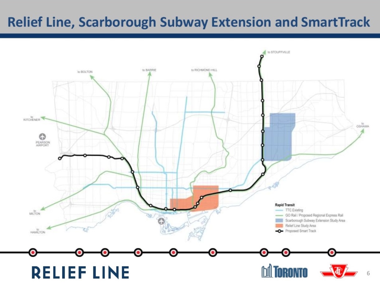
Slide 6: The context for the linked studies is the GO Regional Express Rail (RER) planning, the Scarborough Subway study, and the SmartTrack scheme plus, of course, the Relief Line. (Note the error on the map which includes GO service to Bolton as part of the RER.)
Slide 7: An important quote: “SmartTrack is expected to provide some relief to the Yonge Subway and may delay the need for the Relief Line. This needs to be assessed.” Yes, most definitely,and with a realistic view of the network function SmartTrack is likely to offer given constraints on its service level in the GO corridors. Too much hype from the mayoral campaign painted SmartTrack as a single project to solve all problems to the extent that the Relief line would not merely be deferred but wiped off of the map.
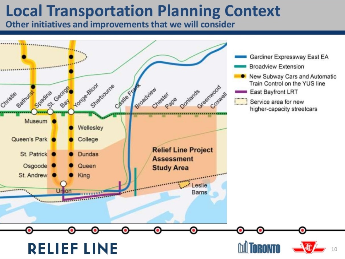
Slide 10: The local network context, the “study area”, embraces the core area from Dundas south to Union Station and a wide swath of the east end from the Don River to Coxwell. One part of the wider context is the question of the future role of the streetcar network with new, larger cars and with the demand effects of anticipated developments in new and existing residential areas. This has not received much attention in the larger context of the transit network, and it has only a small political constituency. Other related projects include the East Bayfront LRT (plus eventual extension into the Port Lands) and the Broadview Avenue extension. Because SmartTrack is very much “flavour of the day”, there are already attempts to downplay the role of the streetcar/LRT network with the false premise that the fine-grained service of a surface transit grid can somehow be replaced by a handful of rapid transit stations. This thinking has even infected the Relief Line study as we will see in a few slides.
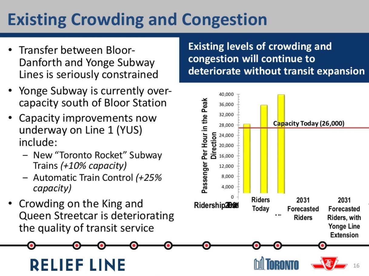
Slide 16: Both the City and TTC acknowledge that there are severe constraints at Bloor-Yonge Station. These arise not just from train capacity, but from the ability of the station platforms and circulation systems to handle the projected volume of passengers. The chart shows a current capacity of “26,000” although the line is actually drawn at the “27,000” mark. This reflects 26 trains at 1,000 riders each per hour, the line as it was when served by the T1 car fleet that has now shifted to the Bloor-Danforth line. The new Toronto Rocket (TR) trains and their 10% added capacity are already in place on Yonge, and the actual capacity of the line is just over 28,000 per hour (26 trains at 1,080 riders each). More can be stuffed in on a peak, crush load basis, but the line and stations cannot operate on a sustained basis at higher levels. Saying that there is a 10% future growth is misleading because the capacity is already in place.
Oddly, there is no reference to the expected 7-10% drop in Yonge line demand that will come when the Vaughan extension opens in 2016 or 2017.
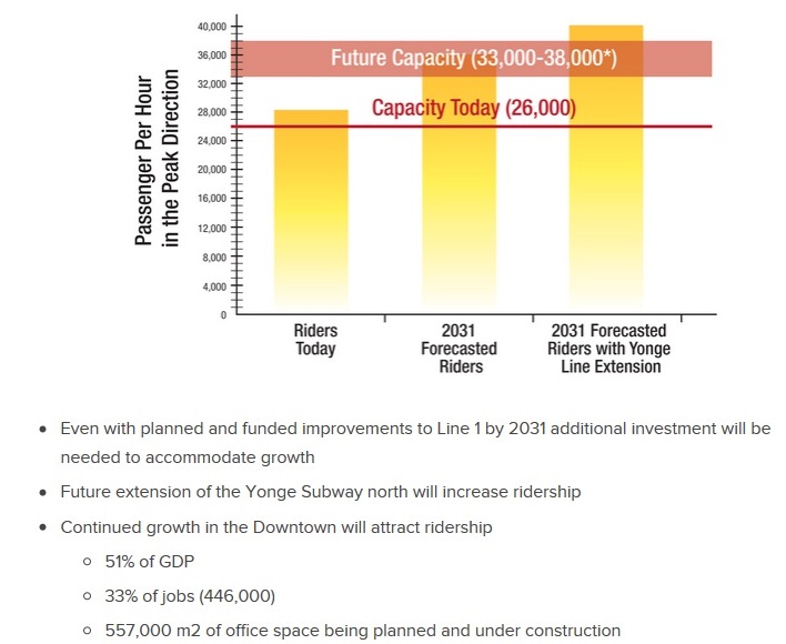
A better chart can be found in the “Challenges” section of the website where the formatting is not distorted, and the 26k screenline is placed correctly. The notes below the chart cannot be ignored. Half of the City’s GDP is generated downtown, and one third of all jobs are located there. The pool of office space is growing and at a rate that dwarfs anything happening in the suburbs.
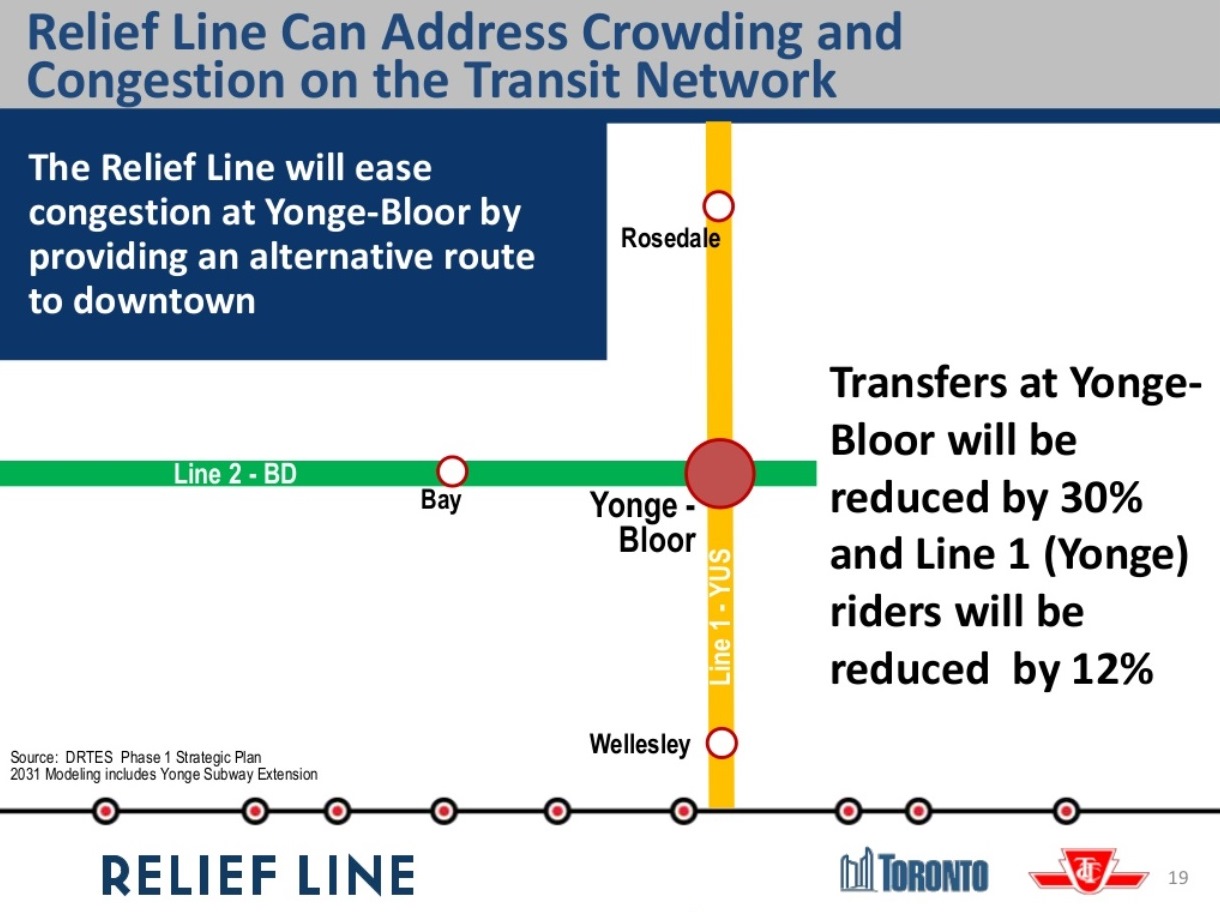
Slide 19 projects a 30% reduction in east to south transfer traffic at Bloor-Yonge and a 12% reduction in line demand south of Bloor
Automatic train control is expected to increase capacity by 25% with reduced headways, the time between trains, down from today’s 140 seconds to about 110 seconds (this is equivalent to a change from 26 to 32.5 trains/hour). That would take the route up to about 35,000 passengers per hour. The range cited in the presentation is 33-38K. Past TTC claims have shown capacities above 40K, but this would require heroic changes to the infrastructure and operations of the Yonge line that would be difficult and very expensive. Similarly, proposals for longer, 7-car trains, are a possibility when the next fleet is ordered in the mid 2020s, but there are physical constraints in many locations throughout the network based on the standard 75-foot x 6-car trainsets that have been used for decades. That would add a potential 10% to line capacity, provided that longer trains were technically and physically possible.
The DRL vs Yonge expansion debate has always been clouded by its focus on the high cost of any new downtown subway, but the cost of retrofitting the YUS to handle larger passenger volumes, and the exposure to greater effects from a single failure in the core area, are never mentioned. A proposed $1-billion expansion of platforms and circulation at Bloor-Yonge is never mentioned as an offset to the cost of the DRL, nor are the extra trains the YUS would need to operate at a higher capacity. To say that this skews the argument against a Relief Line is an understatement.
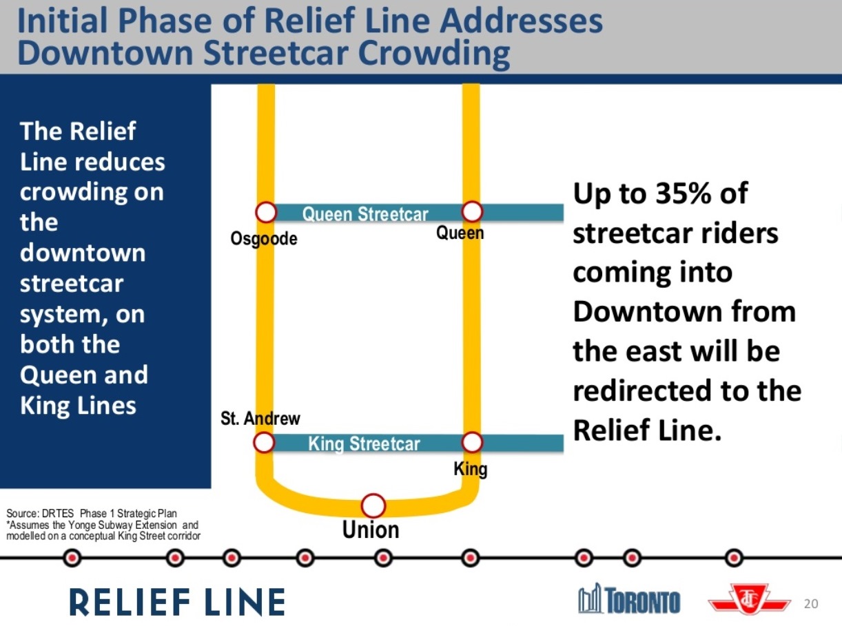
Slide 16 also claims that “crowding on the King and Queen streetcar [sic] is deteriorating [sic] the quality of transit service”. On Slide 20, we see a claim that a Relief Line could reduce streetcar demand by up to 35%. This is based on a King Street alignment for the Relief Line. This is nonsense on a few counts.
The Queen car to the Beach suffers from two basic problems:
First, there is not enough scheduled service – peak service runs every 5 minutes on a line that once had cars every 2 – and far too many of these cars never reach their destination at Neville Loop. The problem is not one of limited street capacity, but of service level and reliability. This can be fixed tomorrow, and a Relief subway is not required, only the will to operate more and better service.
Second, reduced demand implies that riders who have finally gotten on to a Queen car would choose to transfer to the Relief Line. If we we know anything from the Scarborough debates, it is that riders do not like to transfer, especially if this exposes them to the elements. The trip from south Riverdale to the core is relatively quick because there is little congestion on that part of the route. Any travel time saved on a DRL must be balanced against the extra transfer and wait time, plus access time from a downtown station.
As for the King car, it accumulates a substantial load at stops along its route down Broadview and west (eventually) along King. It does not leave Broadview Station packed with transfer trips from the subway. Moreover, if there is a capacity issue on King, it lies more to the west of the core, an area the Relief Line will not touch in its first stage, if ever.
What seems to be happening here is “mission creep” in an attempt to show how much the Relief Line could do. Such efforts might better be directed at talk of redevelopment on the DRL extensions, notably the benefit of heading north through Thorncliffe Park to Don Mills & Eglinton. Alas, that is outside of the study area and therefore ignored.
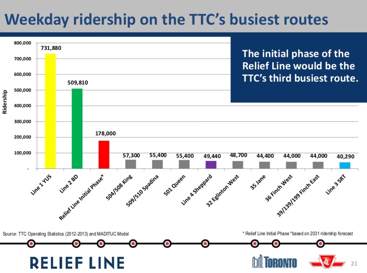
Slide 21 places the Relief Line in the context of other transit projects. With a daily 2031 ridership of 178,000, the line would outstrip by far all of the heavy surface routes, as well as the Sheppard Subway and Scarborough LRT. Although not shown here, I suspect that the Scarborough Subway and the eastern leg of SmartTrack would not fare as well as the DRL either.
The remainder of the presentation takes us into the station location issue I have already discussed above.
Advocacy for the Relief Line
The Relief Line has few friends and is beset by numerous accusations that it is somehow a sop to pampered downtowners rather than a much-needed network improvement so that there will actually be capacity for riders into the core from all over Toronto. [Note to commenters: don’t even think of trotting out those arguments again here. You have made your point in other threads, bogus though it is.]
“Relief” is always something for another day, or another proposal such as RER and SmartTrack. What we will almost certainly learn as the Metrolinx studies advance is that there is a limit to the demand the commuter rail network can handle, no matter what colour or logo one puts on the trains. There are physical limitations on individual corridors, and a combined limit on train and passenger volumes at Union Station. The rail corridors can divert traffic particularly from the outer 416 and inner 905 away from the subway lines, but the fundamental problem is that there will be more demand into the core than capacity. The Relief Line cannot be wished away by election rhetoric, and ignoring the eventual need for a new central subway route is folly. Sadly, Toronto Council and Queen’s Park are very good at “folly”.
What is badly needed is real advocacy for the DRL for its potential role in opening up capacity to the core and to areas beyond the core an expanded route can serve. This is an economic development issue that will benefit much of the City, not just a few blocks near King and Bay.
Picking ideal station locations on the first, truly “downtown” stage of the project perpetuates the idea that this is somehow a route to take folks from Riverdale to the business district when the Relief Line’s role should be much greater. Toronto needs to talk about that wider context and build a constituency for the Relief Line beyond Danforth and University Avenues.

There a variety of options that can provide sufficient ‘relief’ to the southern part of the Yonge line and Bloor-Yonge station. What I would like to see is more discussion about what other benefits the various options can bring. The DRL won’t just provide an alternative route to downtown for from the east; it will add new stations to the subway network, with all the potential advantages that can bring.
For example: the density in the downtown does extend a significant distance east-west from the subway lines. The DRL could allow additional high-density employment in the land to the east. I’ve yet to see this touted a feature of the DRL (or a fault, depending on your point of view).
Steve: Yes, definitely. The TTC has been so focused on the DRL having only a limited value as “relief” that it never looked beyond this function to the network and development benefits. City Planning is taking a better approach, but the current study is still hamstrung by looking only at the first phase, and even that without fully considering development possibilities.
LikeLike
Yes, and amen sir. As seen by the approach of many from the outer 416 areas in the debates surrounding transit, this would be much easier if the downtown portion only served the handful of major employment destinations directly and the likely transfer points in and very near downtown. Other stations – which should be focused on and attract real general political support – would be in areas beyond the study area.
To me the stations that should really be being discussed are at Eglinton, Thorncliffe Park, Flemingdon Park, Danforth, Lever site, and the core.
Also Steve – reading through you mention the TTC is discussing 110 second headway for the Yonge line based on new signalling. Does it not take well over 120 seconds to turn a train with the current geometry? So is the difference to be made up just with added trains during the peak hour? If so from which yard?
Steve: The TTC claims that they can get down below 120 seconds with completely automatic operation and very strict crew management so that trains leave terminal stations inbound the second that the route is clear. This would probably involve closing the doors while the next trains is still entering the station so that the “door delay” could be eliminated. Today, the doors don’t even start to close until the signals clear, and this depends on the crew being in place and ready to leave.
Another option is to insert a train from a location where there is no conflict such as a tail track beyond the terminal, or a line station such as the “gap train” operations from Davisville. However, the short headway eventually gets to the other end of the line where it could produce quite a backlog.
LikeLike
Agreed. It’s utterly foolish not to talk about the need to extend it up to Eglinton and go through Thorncliffe as part of the first stage. What a joke this “study” is. Thanks as always for the great work Steve.
LikeLike
I like the way that the slide of the “Relief Line, Scarborough Subway Extension and SmartTrack” show SmartTrack with the boldest line and all the station where as the lines that do exist are much lighter and without stations. It is as though SmartTrack is viewed as a “Fait Accompli.”
The TTC Rapid Transit lines include St. Clair, Spadina and Harbourfront, but do not show The Eglinton Crosstown or the York Vaughan extension lines as under construction. It also leaves off the RT but who can blame them for that omission. I like the fact that the Broadview extension on one map shows up as green; is it going to be part of the GO system?
Steve: No. The choice of colours was rather arbitrary. Also the errors in the maps always give one pause about the degree of familiarity the project team has with all of the details. Even if a junior drew the maps, the errors should be caught by those at a more senior level.
By stating that it will provide relief for existing street car riders to get downtown it is like throwing raw meat to the baying hyenas of the woe is Scarborough crowd. I wonder how many people will make the extra transfer to get on the DRL if they already have a seat. Then Again they may remove the streetcars on King and/or Queen. This will just add fodder to the anti street car crowd because if we are “dumb enough to build another subway for the downtown elitists” then we can get rid of the GD streetcars so I can drive more easily.
Steve: They seem not to be going after streetcar abandonment, but piggybacking some benefits for “relief” of more than the subway. This is a red herring, especially for the eastern leg of the DRL as I noted. I am reminded of planners in the 1960s who presumed that after the BD subway opened, ridership on the King car would fall like a stone because everyone would take the subway downtown. They completely missed the fact that most demand did not originate at the subway when they cut the headway from 1’40” to 4’00”. I think that some of the same mentality is at work here coupled with a demand model that simply cannot deal with the fine-grained movements of surface routes.
The fact that its proposed ridership will be greater than everything but lines 1 and 2 is good but how will it compare to the proposed line 5 (Eglinton Crosstown)? The study and public input is necessary to get the idea of this line from the far distant future up to a more important area, but I don’t like the way it is being done. As you said in an interview last night the final line will look like spaghetti was dropped on it from a great height.
LikeLike
One senses in this the usual: consultants happily being paid to ‘go through the motions’, trying not to offend anybody while the TTC and City staffers wait for the real decision makers, aka the municipal and provincial politicians, to make clear where the magical money pot will go. In the meantime, we get all of the superficial trappings of a real study (numbers! charts! consultations!), at the same high cost as always and with very little depth and very little willingness to challenge status-quo assumptions. What a wasted chance.
LikeLike
Thanks for parsing this out, Steve. I was unable to make the first meeting because I instead attended the first First Gulf 21 Don Roadway/Unilever Site meeting. I’ll be there with bells on Thursday, however!
I’m given to wonder if the Employment Density projections include any such developments. At a glance, I’d say not. Further, it doesn’t look like they expect any development south of Lakeshore (yes, entirely contingent upon WaterfronToronto development of the Lower Don Lands) before 2031 either.
This study is quickly becoming as notable for what it overlooks as for what it is looking into. Still, we’ve go to make the effort, right?
LikeLike
I’m a software developer and I’ve learned that it’s hard to do big, expensive projects that do new things, partly because it’s hard to get agreement on exactly what the big project should do. But it’s easier to take an existing thing that was done quickly and cheaply and is successful and muster the will to improve it. So prototyping is a good way to do big and complex projects, by starting things with a small thing that can work by itself, and then over time improving it by replacing it with a better working version of the same thing.
I’ve felt that part of the problem with the DRL is that it’s so big and expensive that it’s hard to muster the will to do it, no matter how obvious it is that it’s needed. So my thought is that maybe it can be prototyped. What about running very frequent express bus service from at least one if not several Danforth line subway stations direct to downtown? For example, from Pape down Pape/Carlaw to Eastern, and across Richmond to Bay or so, then back on Adelaide. With NO stops until Yonge. Or down Woodbine or Coxwell and across Lakeshore, no stops until the pedestrian walkway at Bay.
Surface seems slow, but I bet this would be fast enough to beat the subway if there are no stops, and would attract significant ridership – thereby directly easing congestion at Bloor and Yonge, at a relatively low infrastructure cost and with relatively short development time. (How long does it take to buy a hundred or two buses compared to building a subway? There may be issues with bus platform capacity at some of the stations, but worst case some buses could connect on the street until this can be rectified. And maybe it would be necessary to adjust traffic patterns to give the express buses some priority lanes, but that’s just paint and political will.)
I know this isn’t a perfect solution, but it has the advantage of being relatively cheap and practical and implementable quickly… and as those buses fill up the clamor to replace them with a subway would increase.
I’m a huge believer in the DRL and light rail, but it seems to me that we need some practical short term solutions while we argue about the best long term ones.
Steve: To provide the equivalent capacity of one subway train requires about 15 articulated buses. This is rather like telling someone you will prototype their new system on a Commodore Pet (or possibly several Pets in parallel).
LikeLike
Not near Union Station. Preferably north, between Wellington and Queen Streets.
LikeLike
… or maybe better SOUTH of Union where there is a great deal of current and planned development from Parliament to Spadina.
LikeLike
I’ve never really considered the Yonge-Spadina line to be one line, but two. It would be helpful to separate out the stats of daily usage by looking at them separately. The same with the Bloor-Danforth line, they’re really two lines that each go downtown during peak hours.
Steve: The best surrogate for this would be to look at the station usage stats. In the central city this is tricky because people coming to the “U” originate everywhere, but out on the four “branches” one can compare total counts at least for all day usage.
LikeLike
For the Danforth connection, I reject Greenwood and Coxwell as being too far east. Too many Danforth riders are to the west of these stations, and future expansion northwards would result in the bypassing of Thorncliffe Park. Broadview is too close to the edge of the Don Valley, the catchment area of the future stations to the south and north on Broadview would have fewer trip generators.
So either I say Chester (via Logan), Pape or Donlands.
Chester would have the shortest route and therefore the lowest cost, but it has the fewest nearby trip generators.
Pape is the busiest street and has the most nearby trip generators (especially at Gerrard and at Cosburn).
Donlands is the most expensive route due to distance and has fewer nearby trip generators, but would not require connecting tracks at Danforth, a tunnel could be built from the west side of Greenwood Yard.
Personal preference in order would be Pape, Donlands, Chester.
Thoughts?
Steve: I have long advocated the Donlands route provided that the challenge of getting from Danforth south can be solved. If Pape, there is the question of whether a tunnel, possibly even single track, could be built to Greenwood Yard via the rail corridor as a service connection. A full wye at Danforth would require destruction of whatever intersection it occupied. Chester is a non-starter.
LikeLike
In my mind the important sites are:
– George Brown’s St. James campus/St. Lawrence Market
– the office buildings near Berkeley Street/Distillery
– Unilever site
– Gerrard Square/Riverdale plaza
– Thorncliffe Park
– Flemingdon Park
These wouldn’t be the only stations I would build but any line must serve all of these areas.
I wonder though why the study keeps referring to University as the vicinity of the westerly end point. Surely it would make more sense to end the new line at Spadina at the very least.
At King, there’s a low-rise building (the LCBO) that could be knocked over for a new station access. It would also make the handful of proposed office towers near Spadina far more desirable for businesses.
In the other scenario if the line were to take Wellington, an underground terminal could be integrated directly into the proposed Well development.
Steve: There is already a development proposal for the King/Spadina LCBO site. Further south is the pending redevelopment of the Globe & Mail site at Spadina/Front that would mesh nicely with a new GO terminal on the south side as a major node. There are already condos to the southeast, and a new development has just been proposed for the northeast corner.
LikeLike
I had some interesting chats last night with current and ex-politicians about their thoughts on Mr Tory so far/in general… as well as some of my friends who are internal CoT technocrats.
The overall fear is that ST will displace the DRL and many other great initiatives that were started last term in spite of our dear Mr. RoFo, who was more of a laissez-faire dumbo, than his boisterous/bullying older brother (who it’s well known was the real problem at City Hall). JT cares about the details and due to his reputation is being allowed to stick his nose into everything, and is a heavy hitting influencer with a whisper here or there.
That being said, I tend to be an eternal optimist and am heartened by his comments today at ULI’s AskMayorTory event in which he was quoted in saying – “Relief Line is a 12-15yr project. He wants to focus on SmartTrack (7 yrs). But both projects will run simultaneously. ”
I think this means (in light of the timelines), that he will fund/allow for the DRL consultation to continue, then I’m sure that they will be willing to fund the 6-month TPAP, which puts us into Summer 2016. It’s at this time where I’m uncertain with how it will go ahead. If the city decides to manage the detailed engineering design themselves separate to the construction, then we’re now at Fall 2018 before any construction can occur/decisions made which unfortunately lines up with the next Provincial/Municipal elections. OR, maybe they go the P3 route, and it’s a DBB (at minimum), which would make this thing a bit more of a guarantee sooner.
I will add that the “east of the Don” politicians distrust the TTC as they feel that the TTC does not know how to run a project on-time or on-budget and is self-serving. There are bad tastes in their mouths from Leslie Barns, and some of them indicated that they’d prefer Metrolinx to run with the DRL project. They don’t trust what the TTC is telling them.
Steve: I’m not sure John Tory realizes just how much damage SmartTrack did by his position that it was the “one line” to solve all problems. He may have backed away from this, but it set a tone in which the long-standing opposition to the DRL was allowed to flourish. It also, of course, could be a mortal blow to the credibility of the Scarborough Subway. I will have a severe case of schadenfreude if the SSE simply becomes unaffordable through its extra length and poor projected ridership thanks to ST.
As for Metrolinx, ask the folks in the Weston corridor just how much they trust Metrolinx. This is a case of “the grass is always greener”. Both the TTC and Metrolinx are capable of totally cocking up a project, especially when it comes to meaningful and informative public participation. That said, the TTC’s long opposition to the DRL would make suspect any embrace of it by staff, and there is still enough disinformation (some of it at last night’s meeting) coming from the TTC to warrant suspicion. As for Metrolinx, they regard the DRL as a “local” project that has nothing to do with them, notwithstanding its vital role in the network. They have yet to explain just how an Eglinton line from Kennedy to Mount Dennis qualifies as “regional” beyond the fact that Dalton McGuinty said it was so.
LikeLike
Many years ago in 1929, NYC Transit, or who ever was in charge, proposed the 2nd Avenue Subway extension. In 2007 work started on this subway extension. Completion date is 2016/2017.
The DRL concept has been around for how long?
If the Scarborough subway (yet to be built), or Smart Track (yet to be built or portions thereof) or the DRL, are never built something else will.
If any new transit systems are built eastward and cut off ridership on streetcars lines in East York, so be it.
Steve: There are no streetcars in East York. The last time one was proposed was in the 1920s when cars would have run north on Pape to serve the industrial district in Leaside. If you’re going to slag the streetcar lines, at least get your geography staight.
LikeLike
Why can’t they just call it the Red Line or Line 5. Relief line and downtown and all that just feeds into so many preconceptions, seems like shooting yourself in the foot out the gate from a marketing perspective.
LikeLike
It is hard to estimate that percentage without some ridership modeling, and before the route of DRL is finalized. However, I would expect that the streetcars will see a substantial relief.
I assume that some of the current 501 and 504 riders do not live along those routes; they take another bus / streetcar, transfer to 501 or 504, and use them to get to their downtown destination. When DRL opens, they will be able to take another bus / streetcar to a DRL station, and will no longer use 501 / 504.
Steve: Well, no they won’t. The King car is fed by bus routes at Broadview Station (four of them). Unless these lines are rerouted and/or extended south to make a direct DRL connection, their demand will not shift. Flemingdon Park is the one route that would easily be shifted east to Pape or Donlands. As for riders originating on Broadview and on the eastern part of King, there is unlikely to be a DRL station in walking distance for any of these people. It is not uncommon for a car to leave Broadview Station with a seated load but be passing up riders by the time it is heading west from Broadview and Queen and into the eastern part of downtown. Some riders will shift, yes, but not 35%.
Another group that might switch are 501 riders who live along Queen East and whose destination is at King, or south of King (I assume a King or Wellington alignment for DRL). It will make sense for them to take 501 initially, then transfer to DRL, and get closer to their destination than they would be if they stayed on the Queen streetcar. They will still use 501, but not its busiest downtown section.
Steve: Queen is different from King in that relatively little of its demand originates close to the core, although this will change gradually as the area redevelops into more affluent and higher density housing. The load originates mainly east of Broadview. You may intercept it at, say, Pape and Queen, but this will not eliminate the need for service. If anything the demand might increase. We really don’t know what the latent demand on Queen is because the service has been so unreliable for the past two decades thanks to the combination of service cuts on top of the wider ALRV headways and short turns.
In both cases, there is the west side of these lines which the first phase of DRL won’t touch at all. The population is spread out enough that it will be hard to serve with one subway line as a streetcar replacement.
In any event, a DRL is so far off in the future, and an uncertain one at that, that folks should not start paving over tracks in their minds in anticipation of the demise of the streetcars.
LikeLike
Although everyone here is happy to criticize the Sheppard subway, one thing that cancelling the extensions (to STC and Donwsview) has done is to make the public suspicious of making plans for a second phase.
Even though the true benefits of the DRL may be more obviously realized when it is extended north, will anyone actually trust that any phase 2 or 3 plans will actually be built.
Another example is Eglinton West. It went from BRT to subway, then to LRT, then phase 2 LRT, and now it has dropped off the map. The bigger the network that is planned, the more chance there is to disappoint the public when those plans change.
Steve: For what it’s worth, Metrolinx is actively investigating the link from an Eglinton West LRT into the airport (the one part of the line that has not yet been designed) according to info at their board meeting on March 3. This suggest that despite SmartTrack, the Eglinton West line is still very much alive. Once ST’s Eglinton branch dies its well-deserved death, and ST is rerouted to stay on the rail corridor, we can have an intelligent discussion of LRT extension options.
As for the Downsview Sheppard subway, that was never a viable proposal, and was only a leftover from the very early version of the Yonge-Spadina loop that would have seen both routes ending at Sheppard. To imply that this line was every a realistic member of the “pending projects list” is misleading.
The eastern part of Sheppard, I agree, should have gone to Victoria Park as originally planned to bring the Consumers Road district into subway territory. All the way to STC is quite another matter. The reason it stops at Don Mills, of course, is that Mike Harris needed a Sheppard line to keep Mel Lastman happy, but wasn’t prepared to spend another nickel on the project. Neither was Toronto.
Note that I am saying that only in the context that if it was to be a subway, then Don Mills was not the logical place to stop, but as usual in Toronto cutting costs took precedence.
LikeLike
The big thing I want to know before deciding on a DRL route is where the GO RER or SmartTrack will go. If all this service will go to Union, then Wellington can be used for the DRL. If the GO RER and SmartTrack service will overload Union, then possibly a Wellington tunnel could be used for GO, and then the DRL would be pushed farther north (i.e. to Adelaide – since I think there are benefits to avoid the construction disruptions on King and Queen).
Steve: Yes, the whole business of looking at stations in the absence of routing information for this and other competing proposals really misses some important issues in the evaluation.
LikeLike
What you mentioned is a tangible added benefit, but not a selling point. Too many inner suburb residents (not just Scarborough) will hear about more density in the downtown, and complain that downtown has too much transit already.
Their presentation strategy, that emphasizes Yonge relief and Y/B station relief, is suitable for the early stages of the project. Local density considerations should be added a bit later, during the route selection.
I agree with those who want the Danforth-to-Eglinton section included in the study process. Even if that section is not funded in Phase I, it can boost the overall support of DRL.
LikeLike
Bus #100 Flemingdon Park may be re-routed as you said. Buses 8, 87, 62 may continue to run to Broadview, but some of their riders will shift to # 25, 81, 56 and travel to a DRL station.
Steve: You’re expecting an extra transfer there for riders who are already fairly close to Broadview Station. The claim would be better if the DRL ran further north with a station at either Mortimer or Cosburn. As for walk-in traffic at Broadview, it has no reason to shift at all.
That 35% number may have no basis, but a 15-20% effect would not be surprising.
Though, I understand the concern that even a modest reduction in streetcar ridership may prompt a removal of some streetcar routes or their sections (IMO, that would be a bad idea).
LikeLike
Rail corridor is the obvious choice.
Steve: Except that SmartTrack will eat up whatever space might be available.
LikeLike
I would imagine that any construction of a DRL will be similar to Eglinton – in that we will build a tunnel first, with headwalls, and that would likely be a multi-year project – with an insertion point somewhere on the west side of the city and extraction at Bloor (or potentially a continued dig, up to Eglinton) … if we are done a TPA sometime in 2016 and 2018 we have a design, then it’s likely 2019 before we have TBM’s, and 2020 before they are in the ground digging … 2022 for passing Bloor, then all the stations need to be built … 2025 at the earliest … that’s assuming funding is done pretty quickly.
One of my main concerns is that the city start to protect the station locations, but also that we start to see requirements for new buildings in the area to have PATH connections as the stations on the shoulders will likely be outside of the current PATH zone…the more PATH connections, the larger the catchment area will be – one would assume the Lever site would try to do this, but it’s not a given – I wonder about the buildings in the Distillery and Canary District – how many were designed with the potential for underground connections?
LikeLike
It would be interesting if the attendees had a chance to put dots up on a map showing their preferred station locations.
Somehow I’m wondering how effective the data from the feedback about station locations can actually be. I would be surprised if they got 1000 public submissions. How will that be weighted against other more significant costs like … well … everything.
The 25% projected increase in Yonge line capacity from ATC and the projected “up to 35%” transfer from the 504 & 501 to the DRL may not be as overestimated as the projected numbers for the Scarborough subway … but I think I would discount them by 5% immediately … just because.
Cheers, Moaz
LikeLike
But Steve after RER what space is there really for SmartTrack ?? Is there really any room into and through the core after a real GO expansion between now and say 2031? Given the USRC and Union Station situation – Will ST not require a couple of 6-7 meter deep bore tunnels for a huge chunk – thus, being more expensive and delivering less capacity than a DRL would?
Steve: At some point fairly soon, I think everyone is going to have to start treating SmartTrack and RER as variations on a theme. Metrolinx talked of ST as a “subset” of RER at its recent meeting. It is truly ironic that in a very short time span, we have gone from a GO/Metrolinx that refused to discuss more intensive use of the rail corridors seriously, and invented bogus reasons why electrification would not work here, to an overcommitment of the capacity by politicians who see this as a quick way to expand the network without spending a fortune on subways.
LikeLike
Well I have a few thoughts about the DRL or whatever it should be called. First of all, I only ever see a proposal for it going east from Downtown. The way I think it should be built is coming from Dufferin loop area into downtown running under King street or nearby, maybe just off of the rail corridor. Then it would connect Liberty Village and the Exhibition grounds to downtown, therefore relieve pressure on the 504 service. Then it could continue from downtown and head to either Pape or Broadview because of all the bus connections at the stations. If the service is built right, there would be stations in key areas leading both east and west of the core of downtown. I personally think Pape station is the better choice and it is better because it can be extended from there allowing it to be built towards Don Mills and Eglinton, connecting to the Crosstown. I know the main so-called logic of a subway extension to Scarborough instead of the LRT is to eliminate a transfer at Kennedy, but with my idea running the Scarborough LRT like it was proposed and voted on in the Ford-era more people may take the Crosstown and then transfer to the DRL at Don Mills.
As part of a phase 2, I personally think that it should be extended on both ends. From Dufferin it should then be built west going to Long Branch relieving pressure on the 501 as well as the west end of the Bloor/Danforth line. From Don Mills and Eglinton it should be extended to the Existing Don Mills Station connecting to the Sheppard Line and going to the Yonge line that way with a possible extension from Yonge to Downsview even. This way it is almost a circle line but connecting lots of major areas eventually.
Also, as part of the relief line would the full Transit City not have been a relief line of sorts? From what I recall there was supposed to be a line built along the Waterfront, going west and the Don Mills line. All that they would need to do is build a connector from the Don Mills to the Waterfront west line and run it as one route. Then if it is routed properly a waterfront line would bring relief to the Yonge line. Moving people down to a waterfront line instead of the Bloor Danforth maybe a more practical idea. Even the Jane line could have been routed further south to connect to the Waterfront West line. In the Scarborough area there was supposed to be a line that would run from Kennedy station along Eglinton to Kingston Rd and then to Morningside and over to the U of T campus there. Well they also had a BRT proposal that could connect from Victoria Park station to Eglinton and Kingston Rd. That could also be converted to LRT and then there would be even more LRT built and technically the idea of a downtown relief subway wouldn’t need to be build. There would be much improved transit in many areas of the city for probably much less then the 3 stop subway expansion and total DRL costs. I know people are skeptical at times of LRT’s but I am sure there is a chance to remove many buses from the routes that the LRT would serve and then those buses can be spread to many other areas to greatly improve service. Maybe Steve, you can give a little more insight on the numbers of buses and the cost comparisons.
I think it’s now time to resurrect the full Transit City.
LikeLike
I would hope that this would quickly refocus the discussion from a city perspective, on the projects that can actually offer the required capacity, and real solutions. While I do not agree with Brian in terms of running subway to Long Branch, it does make sense to bring back the viable parts of Transit City, as a companion to DRL planning. The DRL needs to be planned in terms of how it connects and enables transit across a lot more of the city. The issue in my mind is that it should in effect be used as the primary link to a network for the northeast of the city. The DRL should link directly to Crosstown and Don Mills LRTs which in turn provides a link for a Sheppard East LRT, Lawrence East and York Mills bus routes.
The other end of a DRL could be placed through core to support a link to a western station for RER, and end so as to support a WWLRT that went west from close to the CNE grounds. This single chunk of subway, providing a very high capacity link to support a wide variety of lighter rapid transit that can serve a large portion of the city well. I realize that this is asking quite a lot of a single relatively short subway line, but is one of the major reasons it pains me so to see so much focus being expended on the “downtown” aspect of it, without focusing heavily on what linkages are required and how it can be made to serve those, as an integral part of planning for the entire city.
LikeLike
I think SmartTrack can BE the “one line” to solve all problems:
If you look at SRRA’s regional relief line plan on which Smart Track is based:
– Smart Track is phase1+phase2 in their plan.
– Build phase 4 of their plan (a tunnel on Wellington to divert from Union) is built.
This can be Smart Track Phase 2 and be much more functional than a DRL stubway being planned.
Steve: I have already written at length about the SRRA paper and its two predecessors. There are many assumptions and claims in that paper that are dead wrong, and we are now dealing not just with the fallout from those errors, but from the way the SRRA plan was adapted into SmartTrack with key changes that further invalidated claims made for the service. The most notable flaws are the assumption of very high speed, frequent service that would attract very large demand. The speed is impractical because stations are only a few kilometres apart, and the frequency is impossible given constraints on the rail corridor and the presence of other services.
LikeLike
In addition to buying the buses, you need to build a garage to store them. On top of that, average surface speed in mixed traffic is 18kph or 300m/min, and 15 articulated buses would occupy 132m plus normal spacing between vehicles. So with 2 minute headways, such as the subway would provide, you end up with 25% of the street filled with buses, which then bunch up at every intersection.
If “adjust traffic patterns” where just a matter of “paint and political will”, we could save all the costs and just exclude all non-transit vehicles from the given streets and we’d all be happy. However, Toronto’s issue is that all our systems are overloaded, not just transit, which is why there is such resistance to road-for-rail switches, whether that is actually a dedicated LRT ROW or a dedicated BRT ROW.
It’s all a matter of what you actually intend for the data to do. Generally speaking, “public feedback” is a legislated requirement, but effective listening to “public feedback” is not. You can manipulate data in many ways to get your desired result, from geographic averaging to frequency analysis to how-many-in-the-circle. For example, the image of Earth with “more people live in this circle than outside it” uses an orthorectified image of Earth but a normal circle, so really it’s not a circle, but it delivers the intended political message.
LikeLike
Steve – once you wish away RER and the need to support CN emergency traffic, what?
Let us just spend the money to build another by-pass for Toronto, shouldn’t be more than another $20 billion in rail and land purchase costs – so that we can approach the issue of ST tunnels through the core. Steve – you act like there is a better way to spend say $25-30 billion that we do not have.
I really like the idea of getting a full costing on ST (including the requirements of another bypass) it would be good to make the DRL option Don Mills& Eglinton to the Exhibition look really cheap and would cover more than the full cost of a complete Transit City on top of it (also do a great job of making Miller look like the realist he was).
Steve: I am going to treat your comment as sarcasm, although I don’t understand the remark about “a better way to spend [money] we do not have”.
If there has been any consistency in positions I have taken, it is that there is only so much money to go around, and on the time scale of transportation projects, the rosy announcements of billions when times are good inevitably fall apart when times are bad. I have been through several of these cycles already, and don’t even trust the current $29b round. The cost estimate for ST was done on the back of an envelope simply by saying “it’s X kilometres long” and “we had a similar project in London, UK at Y $/km”. That was the extent of analysis and out popped that $8b plus figure. The campaign team couldn’t even make up its mind for weeks about whether the estimate included any tunneling for their “surface subway”.
Meanwhile, we have other projects that go begging for funding because they don’t fit into anyone’s election plans. That’s where we should start talking about spending money we don’t have.
My alternative to SmartTrack is simple: recognize that it is nothing more than an expansion of service in the GO corridors, and work within the limitations those corridors bring. Acknowledge the role an expanded DRL can provide — after all, an underground ST starts to look a lot like a DRL subway — and stop pretending that the material produced by SRRA and the CUI is at all relevant to the discussion.
In many ways I am a fiscal conservative, in the sense that we cannot possibly afford the programs we need if we spend all of our money on pet projects to win elections.
LikeLike
Steve – is there something which shows the level of ridership on the Bloor Danforth line east of the core – not the number of people using stations, but how many people ride the trains on each part of the line.
The problem is mainly one of YongeBloor Station. The maps showing the employment and population density in Riverdale clearly make a point that there is no need for a transit line to run east of the Don River, nor does the Official Plan call for adding more people or jobs to that area with the exception of the First Gulf site, perhaps, and a bit farther east along Lakeshore Eastern.
I still think that the cheapest and easiest way to relive pressure on the Yonge line is to link a north south line into Castle Frank Station – something which is not being studied…
The idea of the DRL goes back 100 years – to when the built-up area roughly corresponded to the old city of Toronto and when the Bloor Danforth line was not in place – it would have been the only transit line and would have been the only line feeding people directly into the core – providing service where no rapid transit existed other than the streetcars. the problem today is quite different.
Think for a minute – imagine that the BD line is at capacity at Bloor (in the future) very little of the ridership is, or will come, from stations between Pape and Yonge – it is mostly coming from Scarborough.
If there are 36,000 on the subway at Pape or Broadview, there is no way that 100% of them will be going to the core – and who knows if or when there will be a line going up to Don Mills and Eglinton, which is not a major node in the official plan.
the point being that there is no point building a full 36,000 passenger per hour subway to provide “relief” from a line which also has a 36,000 passenger per hour capacity – an undergrounf lrt should be able to provide adequate capacity at 20-26000 passengers regardless of whatever station it links into east of Yonge.
An underground LRT station from castle Frank will be at least 2km shorter than one going to Pape, it will not need expensive tunneling under the Don River, and as the density maps show, a line running under Sherbourne will help provide improved service east of the core in areas with high existing densities of people, and jobs, and where the official plan calls for more in future.
East of the Don River, there is little or no ability to densify a new transit line between Queen and Danforth. presumably with Smartrack, transit will be added/improve along the rail corridor to serve areas along the rail line, include the First Gulf site … isn’t it the Mayor’s position that with Smart Track we don’t need the DRL – that we are not going to build both?
If that is the case, then why not improve transit north-south on the east side of downtown?
Steve: At the risk of sounding like a broken record, the purpose of the DRL is NOT repeat NOT repeat NOT to serve demand in Riverdale, but to provide an alternative path for travel between areas to the northeast and downtown. One could make exactly the same argument about much of GO Transit or SmartTrack in that the rail corridors are not exactly hotbeds of jobs or residential density, but the network has an important function moving people around the region.
If you want demand details, look at the Downtown Rapid Transit Expansion Study in which, among other things, you will see that demand from the Danforth side of the subway is heavier than from the Bloor side. All of that demand exists in spite of the fact that east of the Don densities are low (not unlike Riverdale) for much of the distance east to Main Station.
Taking a line to Castle Frank is the worst possible response because (a) there is no real “off loading” of the Danforth subway far enough east to make room for trips originating closer to the core and (b) northern extension from Castle Frank is extraordinarily difficult and far from likely targets such as Thorncliffe Park. As for Don Mills and Eglinton, have you seen the development proposals for lands there? Have you looked at the amount of land already in the public sector that could be developed in tandem with a new junction between two transit lines?
As for the Mayor’s position, it is not that we don’t need the DRL, but that ST will relieve the immediate need, defer the point where it is required. Given development and population patterns, the need for the DRL has actually come forward to the point where previous estimates of “need” are out by close to a decade, and ST merely allows us to keep the DRL far enough in the future to plan and build it before the network collapses under load.
LikeLike
First – amen yes it is sarcasm (couldn’t figure how to slather it on any thicker). Second – of the 29 billion that is “budgeted”, much of it is in out years, and is precarious at best (as you so clearly note). The one thing that being honest about costing ST would be it would make it clear there is no free lunch to be had.
Amen, and the voter needs to get wiser about the issues surrounding free lunches. If it is what you really hoped to hear and were afraid was too much – look harder, you are likely being duped, or worse it will be done, and the regrets for the mistake will be large.
LikeLike
Sorry but to add to your point – there is also the massively important issue when addressing the extension to Eglinton – of being able to link other projects in the future beyond that point. We need to get to Don Mills & Eglinton – because beyond there (north and east) LRT is possible in the 2 chain road allowances – meaning room for 6 lanes and an LRT, as opposed to 1 chain wide in the old city.
LikeLike
As I’ve said before, the Downtown Relief Line needs to be extended north of Eglinton, at least as far as Finch, to reduce overcrowding problems on the Yonge line north of Eglinton as well as DVP traffic congestion problems. This route would be more useful than the Sheppard subway for residents at Don Mills/Sheppard given current travel patterns. We should be planning a proper third subway line that likely would have ridership as high as Lines 1 and 2 if fully built (let’s call it Line 3 reusing the SRT’s number), not a short stub from Pape to Union which would have low ridership.
GO train expansion is not a very good substitute for the DRL because the Richmond Hill line is a poor substitute for the Yonge line and the Stouffville line is too far east. SmartTrack is just a fancy name for electrification of the Stouffville and Kitchener lines, double tracking of the Stouffville line will start this year so my guess is that much of “SmartTrack” will be built by 2018. The Eglinton West GO trains proposal is of course absurd and hopefully the engineers will reject it as impossible/prohibitively expensive, and I hope that Tory is sensible enough to abandon this idea.
LikeLike
PS – It almost makes you wonder about the design for a DRL, assuming it gets to Don Mills & Eglinton. I have long thought that the area around this seems like it has stopped entirely because roadways and transit into the area are already overloaded. I wonder about the impact of removing that cap, especially with a connected DRL/Crosstown/Don Mills LRT combo, so that both the office and housing possibilities of the area are unleashed.
LikeLike
It’s amusing to me that Slide 21 essentially argues that there is no need to upgrade the SRT with a Line 2 extension.
LikeLike
Have you looked at the ridership projections? The opening day reference cases are 18K pax/h or 20K pax/h with something like ST operating. The cost difference between underground LRT and subway is marginal, mostly stemming from platform lengths, which dictates total capacity. If the difference in cost savings is more than 40%, I’d prefer to go with the option that gives us more than a two decades of growth potential.
LikeLike
Has there been any thought towards an elevated line? I’m not sure that this would be cheaper than a subway but it seems to be rarely discussed, perhaps due dissatisfaction with the Scarborough RT. One could be built above Front Street East, Wellington and Loop Via Piper Street. A bridge over the Don Channel might be easier than a tunnel and there is a bit of land east of the Don for an approach.
Steve: Not a chance. You really want to propose an elevated over busy downtown streets?
LikeLike
Beyond the specifics, some form of DLR seem like a no brainer. Can you enlighten me what form this long opposition has taken and why the TTC would not embrace it (it seems in the oragnisation’s interest).
Steve: For many years, there was a subway faction within the TTC that wanted to push the Yonge line to a claimed very high capacity. Part of the rationale was to push through a Richmond Hill extension on the grounds that the added load could be handled by the line. This was a fantasy, but it was the claim. I can remember statements about 90 second headways that were taken as gospel because the politicians (and I suspect some of TTC senior management) didn’t know any better. The DRL threatened the Richmond Hill line both by the amount of capital it would consume and by the premise that it had to be built first to release capacity on Yonge.
This is probably the most egregious example I know of how the TTC very badly served Toronto, and why I deeply distrust “expert” claims about any proposal that comes forward.
LikeLike
No. I realize that an extra transfer will not be appealing in this case.
Rather, I assume that many riders in East York or Riverdale have access to both an N-S local route and an E-W local route. For those, a trip to downtown using DRL may involve same number of transfers (exactly 1) as a trip using 501 or 504.
Example: boarding at Donlands & Cosburn, going to King & Bay. You can either take bus # 87 and streetcar # 504, or take bus # 56 and DRL.
Another example: boarding at Greenwood & Gerrard, going to Adelaide & Bay. You can either take streetcar # 506 and DRL, or take bus # 31 and streetcar # 501.
Steve: You are cherry picking to suit your argument.
LikeLike
Yes, but why build a line through an area with so few people (between Broadview and Coxwell) and where little intensification is planned or possible when other areas not that far away to the west of the Don river already have high densities, and little north-south transit, and the OP calls for more intensification…
Steve: It is becoming extremely trying to deal with your position, some of which jumps around to suit simply being contrary, but I will try (for one last time).
You are bouncing between arguments regarding alignments east and west of the Don river. The line cannot be in both places. Like the BD subway, the DRL’s demand will not come primarily from the immediate vicinity of stations, but from feeder services, notably the Danforth subway. The further west you put the DRL, the less attractive it is as an alternative to Yonge.
Yes, and it is quite possible to connect the BD line at Main to the GO station via an underground tunnel and moving sidewalk, and the 2012 DRTES study also showed potential GO stations at Gerrard and Cherry.
Steve: A connection at Main implies that there will be sufficiently frequent service with capacity to attract people off of the subway line despite the need for a walking connection. The combined effect of that walk and the likely headway in the GO corridor will be a transfer time close to 10 minutes. This is not attractive, no matter how much people talk about the Main connection as some sort of panacea.
The DRL would likely connect to Broadview or Pape. Castle Frank is one station away.
Steve: The connection will not be at Broadview. Pape is the westernmost likely place. Castle Frank is three stations to the west, and on the other side of the Don valley. This is not exactly nearby.
A line from Castle Frank would go at grade or elevated and stop at the Brickworks (giving people access to parkland and a great facility that is hard to get to) and then have a stop at Bayview (connect to Bayview buses) and then along the railway track to connect to the possible GO train station in Leaside, then to Thorncliffe Park/Overlea. Compare that to the 2012 DRTES study which shows one stop on Pape at Cosburn, and then has to cross the Don Valley at the Millwood Bridge (I recall it can’t handle the LRT, and certainly not a subway, and a new bridge would be needed).
Steve: “At grade or elevated”? Through Rosedale? Also, there is no place physically to locate a transfer station with the Bloor subway. You are aware that Bayview is rather a long way down in the valley? The Brickworks is hardly a justification for taking the DRL so far west. You complain about going through low density in Riverdale, but you want an even lower density route further west.
Yes, so we build ST first… but notice that the first DRL station south of Danforth is at Gerrard, which is also a ST station. The rest of the DRL runs parallel and close to ST and so we are building 2 rapid transit lines a stone’s throw apart – the DRL will only get at most 4800 passengers at Gerrard and at Queen in 2031 (pg 58 of the study).
Once improvements are made to GO and Smart Track is built, why build a DRL that runs along virtually the same route with all stations a few hundred metres from the ST ones?
Steve: It is not certain that ST will have all of the stations shown on its map because of constraints in the rail corridor, and it is more likely to get only a stop at the Lever site, not Gerrard. Also, the numbers you cite are boardings, not peak load on the DRL. The DTRES model did not include redevelopment at Gerrard Square.
1800 boardings in 2031 at Don Mills and Eglinton. The DRL proposal that goes to Castle Frank instead of Pape/Danforth can handle that.
Steve: My comment was in the context of serving Don Mills and Eglinton. Note that the study also says that AM peak alightings will be higher there than the 1,800 boardings you cite because this will be a major employment centre. In any event, this has nothing to do with where the line crosses the BD subway.
How far in the future are we talking? Doing the LRT from Castle Frank south is far less expensive and actually does not preclude the DRL. If the DRL were to be an underground LRT (ULRT?) like the Crosstown, and not use Subway/Heavy Rail, then the DRL could merely link into it at King Street.
The beauty of the Castle frank proposal is that it can be in 3 phases.
Phase 1 is to go underground from the Subway at Castle Frank, reuse the bridge over Rosedale Valley Road and have it surface on Parliament south of Bloor – this would link the streetcar/surface transit to the subway much like the Spadina LRT has an underground loop.
Phase 2 is to continue underground from Parliament and Wellesley to the Financial Core – At Yonge and Queen or Yonge & Front or any where in between.
Phase 3 is to go north from Castle Frank to Leaside/Thorncliffe Park. If the Don Mills LRT is built, potentially it will all become one line OR the Don Mills LRT could still go south to Pape, but I see little point
For me, the most absurd thing would be to do ST and then do a subway all the way from Union Station, following close to ST and then have the subway run all the way up to the Crosstown LRT… pointlessly expensive at 8 billion dollars.
Steve: Aha! You want an LRT line. Maybe you have looked far enough into the DTRES to see that the accumulated demand for this line approaching the core pushes the limits of LRT, especially if this is a surface operation as you seem to prefer. This is a very odd way to plan transit — deliberately downplay the demand it might carry so that you can justify a specific technology. I may be an LRT advocate, but this does not include putting the technology where it will be difficult to fit and will almost certainly fail to handle demand. You are proposing a streetcar on a narrow street that would have to be replaced by a tunnel that would almost certainly require the surface route’s shutdown in your phasing strategy.
LikeLike