
This page was created for a talk to course HSE4M Equity and Social Justice. It holds notes about my talk, illustrations and links to other pages of interest.
Requested topics:
- How can transit be fair to everyone in Toronto?
- Rapid transit expansion
- The Scarborough RT
- Why has Scarborough not received quality transit in the past?
- Upcoming new LRT, streetcar and rapid transit lines
- What opportunities are there for advocacy of further growth?
- Improved service and larger fleets
- Delays, short turns and reliability
- Signal systems – subway and surface
- Accessibility
- How transit is important to everyone including motorists
- Transit’s potential effect on climate change
- Transit as access/mobility for jobs, school, shopping, social status
I cannot possibly talk about all of these in half an hour, but the notes below will give readers something to chew on.
What is “Fair” Transit?
I am not going to dig into this question in detail, but any discussion of what transit might do requires some definitions. “Fairness” comes up regularly in political discussions, but it can mean different things to different people, and those meanings depend on context.
- Is transit a social benefit that should be available to everyone?
- What is more important: lower fares or better service?
- Should the cost be the same regardless of the amount of service or travel consumed?
- Should service run frequently enough to be convenient even if buses are not “full”?
- Should transit be cheaper for specific groups such as students, seniors, lower-income?
- Should loyalty programs reward frequent riders e.g. time-based fares/transfers, passes, fare capping?
- Should “regional” service (e.g. GO) charge the same as “local” service (e.g. TTC, YRT, MiWay)?
How you answer this type of question affects what you are aiming at as a “fair” system.
This is not just a question of transit fares and service but of how the city has developed and become more expensive.
The idea of living near your job (or at least close to rapid transit) is undermined when you cannot afford to be that close by. This is compounded when a family has multiple commutes (work or school) to widely separated areas in the GTA. It is physically impossible to be close to all of them, and people spend more and more of their day trying to get from one place to another.
Those who can afford to will minimize their time lost to commuting by living close to good transit or by driving. More recently, work-from-home arrangements allow commutes to be avoided provided your job fits with that model.
A fundamental issue is the purpose of a transit network, and by extension the political and funding attention this will bring. That purpose has changed over the past century from an essential network for mobility for everyone, to one that serves different areas in different ways. In many places, transit is in distant second place to auto travel.
Even Metrolinx’ regional plan, although it will add many riders to the transit network, will at best only keep up with population growth and prevent congestion from becoming much worse. An obvious problem is that we have not been building much new transit, but the population and scale of the region continue to grow.
The cost of housing and the dispersal of job locations force people to live where they can afford even if this then brings very long work or school commute trips for their families. It is very hard to be “fair” on any basis when transit as a whole was not a priority during the growth of Toronto and the surrounding region, and we are not doing well on catching up.
Geography, City Development and Transit
The City of Toronto has a history site which is worth reading rather than me duplicating the info here. It includes:
The early city was very compact. It evolved as an industrial centre along the lake and railways, two prime transportation systems. Jobs were along railway corridors notably Lake Shore East and West, and to the northwest through Weston.
People lived close to where they worked. They walked or took a short transit trip. Cars were rare, and transit was for everyone.
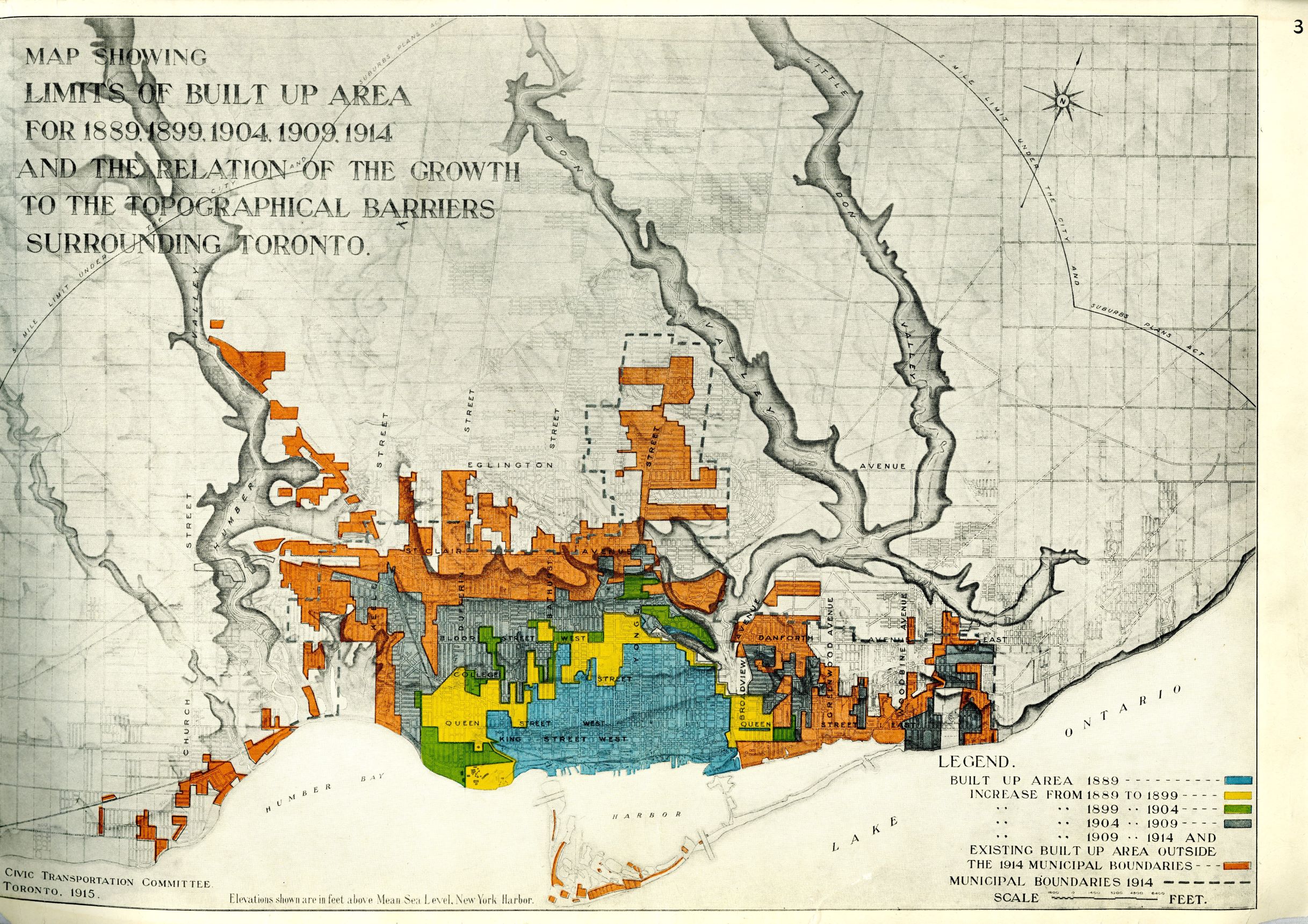
Here is a map of the Toronto Railway Company streetcar network in 1912. Note that there is no Danforth car, and service on Gerrard ends at Greenwood. The TRC refused to extend their network beyond the City Limits as they were in 1891 when they received a 30-year franchise from the City. Toronto built separate “Toronto Civic Railway” lines to fill in some of the blanks notably on Danforth, Gerrard, St. Clair and Bloor West.

In 1921, the City took over the private Toronto Railway Company because it was providing poor service, failing to maintain its infrastructure, and refused to expand its network.
Transit did not just move people around, it was essential to building the city a century ago when most people did not have cars. More transit service and good coverage across the city were essential.

The 1954 transit map shows the extent of service and fare zone boundaries (these were eliminated in 1973). For those interested in a detailed history of TTC fares, please see Transit Toronto’s A History of Fares on the TTC. In 1954, large areas of what are now suburbs had not yet developed.

Post WWII development in the suburbs was auto-centric. Large amounts of farmland was converted for housing and some industry. The importance of a link to railways was replaced by a growing road system and truck-based freight. Over time, this left a pattern of declining industrial areas around rail and marine infrastructure that remained well into the 20th century.
Some of this is visible near MPCI although much of the land has been redeveloped for housing.
- The City Directory for 1960 shows a furnace manufacturer and coal company where the stadium is today. Other businesses in the area included a construction company, a wholesale druggist, and a hosiery mill.
- South of the railway, in the 1920s there were two stables: on the east side was an Eaton’s delivery depot, on the west side was the City’s public works department. The City buildings remain, but the Eaton’s site is now housing.
In the 1960 photo below (taken from a City archive of aerial photography), Hanson Avenue is at the top and Coxwell runs vertically through the centre.
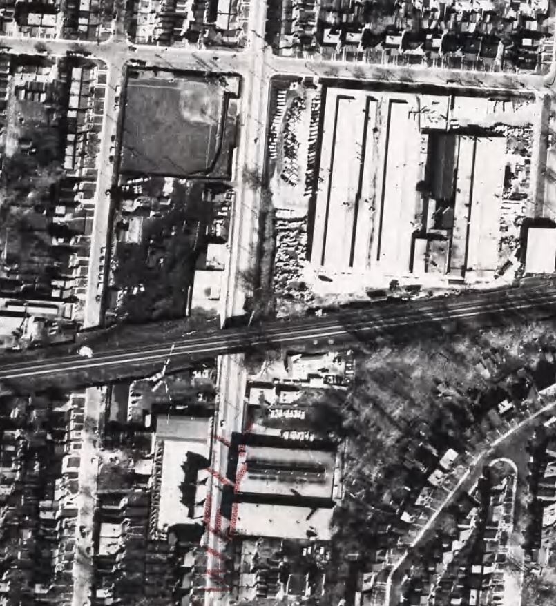
This pattern was common across the city, and industrial areas tended to be the less desirable, poorer parts of the city.
As suburbs grew even further out, especially beyond Metro Toronto, there was very little transit. Everyone was expected to drive. Service ran infrequently, if at all, particularly in the “905”.
Industrial jobs moved to the car-oriented suburbs and home-to-work trips became longer. Cars and roads handled this growth, for a time. However, roads fill up and congestion steals back the time saved.
Broadly speaking, there are three generations of city type:
- an old city based on short trips and transit,
- a post-war city based on cars and expressways with some, but not enough, transit; and
- outer suburbs based on cars.
An important consideration in all of this remains how long it takes someone to get to work. As the city grew, this was addressed by subway extensions and by GO expansion, but both of these are strongly oriented to downtown and the types of jobs found there. Also, they benefit people who live near stations much more than those further away.
GO was intended as a way to avoid widening the QEW, but even as the network grew, it served only travel to the central business district. GO is constrained by the topology of the rail network which itself was built on the smaller 19th century city.
Railways do not connect suburban communities. There are two east-west routes which are freight-only:
- CPR North Toronto line runs across midtown and then northeast through Scarborough where CP established a freight yard in Agincourt.
- CNR York line runs parallel to Highway 7 linking to main lines at Pickering and Malton, as well as the CN freight yard in Maple. This also provides a bypass of the core area and Union Station.
Travel between suburbs is diffuse. The Origin-Destination pattern is not concentrated. Workers come from a much larger area and travel to many destinations over the GTA. There is a similar problem for educational travel to suburban campuses such as York U, Seneca, etc.
Population Growth in the Suburbs
Except for the older suburbs mainly along rail corridors and old highways (Kingston Road, Lake Shore, Weston Road, Dundas Street, Yonge north), the suburbs are new and are designed around a middle-class, largely white, population migrating out of the city in the 50s/60s.
The inner city was backfilled by immigrants, mainly from southern Europe, who at the time were regarded as second class. It is ironic that the “old” city prospered over the years with these new waves of immigrants in neighbourhoods that might have died off as in some US cities.
Transit growth in the suburbs was not designed to carry all demand. Trips were much longer and many areas were difficult to serve without high subsidy.
Some waves of suburban growth encountered opposition because they would change the then character of the area (e.g. Asian malls). Also, land for housing was cheaper in outlying areas.
- Areas around rail corridors tended not to be prime space.
- Industrial areas were underused, or eventually recycled. The biggest examples are downtown with the waterfront, rail lands and Liberty Village.
- The Leaside Industrial District was a major hub until after WW2. Thorncliffe Park was a race track, redeveloped as we know it today in 60s.
- Industrial land provides large blocks, but also large scale gentrification. Where it is already served by transit, there is a starting point, although that may have its limits. For example, Liberty Village is served by streetcar and bus lines, notably the King Street transit corridor.
- The Port Lands, by contrast, is a new development where “transit first” has been hard to come by.
Development has happened along some corridors, notably Sheppard, but this is driven as much by the nearby highways DVP/401 as by transit.
Scarborough and the RT
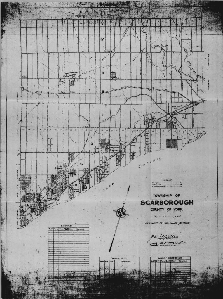
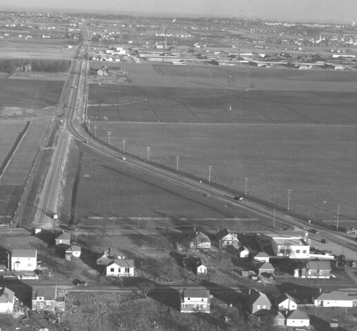
Scarborough in the 1950s was almost entirely farmland except along Kingston Road and the railway line. As it developed through the next decades, there was little history of transit to build on.
The Golden Mile was built on open land in the 1950s as an industrial and shopping centre setting a pattern for suburban expansion.
TTC had a plan in mid-60s for a network of LRT lines extending from E/W subway to Malvern and to Rexdale with an EW connector across the Finch Hydro corridor. Other lines on this plan will look familiar including an Eglinton subway and what we now call the “Ontario Line”.
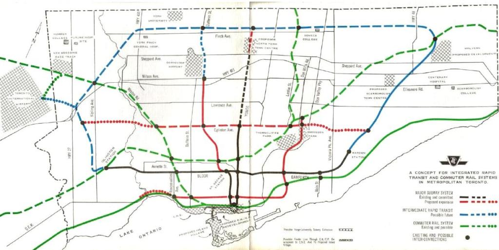
The Province wanted “new technology” and what we got, eventually, was the RT which opened in 1984. It should have been re-equipped or converted by now but technology wars got in the way. The “Mark I” technology has severe reliability problems especially in poor weather. It always suffered from being “new” with many compromises on vehicle weight, propulsion, system control and line capacity.
The idea was to have a new mode with more capacity than buses but not as expensive as a subway, but what we got was an expensive technology without the capacity and reliability. A planned extension to Malvern was never built because of the projected cost.
Within Scarborough, all remaining services used buses, and that network was focused on feeding the RT and the subway. Travel within Scarborough could be difficult if your journey did not match that pattern.
The SRT is worn out and unreliable. In fall 2023 the line will close and be replaced with express buses until the Scarborough subway extension opens in 2030. This situation is a direct result of repeated delay in the SRT replacement project thanks both to budget issues and political battles over subway vs LRT.
GO Transit had service on the Lake Shore East, and later on the Stouffville line, but this was designed and priced for commuters, not as part of the local network.
There is a big problem with misuse of the term “LRT” that goes back to the provincial “Intermediate Capacity Transit System (ICTS)” which was rebranded “ALRT (Advanced LRT)”. Modern LRT using streetcar-like vehicles or small subway cars was tainted by the “SRT” and its problems as a point of reference. Meanwhile, Calgary and Edmonton built LRT networks that are a mixture of surface and on street operation with tunnels only in key locations where they cannot be avoided.
Transit City (2007) included an LRT to Malvern, Eglinton/Morningside line to UTSC and Malvern, Sheppard from Don Mills to Morningside. This plan was designed as a network, not as a single project, but Mayor Ford and his allies killed this off with promise of a subway line.
What we are getting, by 2030, is a subway to Sheppard/McCowan and eventually, maybe on Sheppard east from Don Mills at least to McCowan. This is a long time after the RT might have been upgraded and extended as LRT in about 2014.
But Scarborough has a bigger problem. Much travel is not oriented to downtown, and trips depend almost entirely on the bus network. This has both service and organizational problems, not to mention network design where subway terminals act as “black holes” drawing in all surrounding routes.
More reliable service would be possible through better service management, something the TTC does only fitfully and with varying success on various routes. When crowding is uneven, most riders are on the full buses, and that is the perceived quality of service even if “on average” the buses are only moderately loaded.
Where service is frequent, tightly regulated service is less important and there is a limit to how “on time” buses can be. Any effort to force even spacing would be undone by minor events. Where service is less frequent, uneven spacing can make a big difference. Two buses every twenty minutes provides the same capacity in theory, but much worse service for waiting riders.
Scarborough has two GO lines (Stouffville + Lake Shore East), but no fare or service integration with TTC.
Toronto’s “Three Cities”
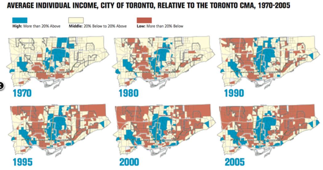
It is impossible to talk about fairness and equity in any public service without looking at the geography of incomes in Toronto. David Hulchanski at the University of Toronto published his “Three Cities” study mapping the divergence of incomes to the overall average by census tract. The map below tracks changes from 1970 to 2005.
The cream-coloured areas have incomes within 20% of the average while blue and red areas are above and below this band respectively. (Note that areas with little population are also shown in cream such as northeastern Scarborough in the 1970s.)
In 1970, the suburbs were mostly average or above, while the below-average concentrations were in old working class industrial districts. However, as time passes, the low income area grows and the high income area gains new segments such as The Beach and new condo concentrations downtown, but also in the Humber Bay.
When this trend is projected out to 2025, the result is even worse with substantial growth of below average areas and the squeezing-out of the middle income area. Note that this only considers incomes, not the compounding effect of housing cost growth.
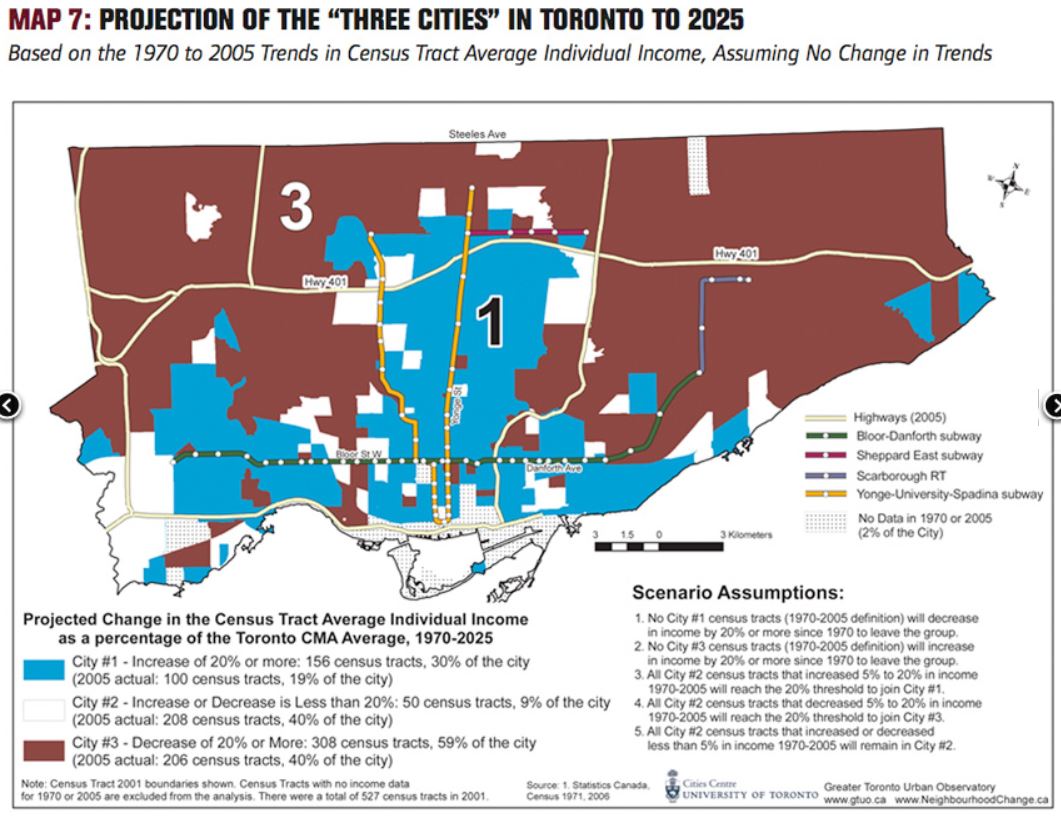
This trend puts more and more people in areas comparatively well-served by transit while leaving a large outer ring with below average incomes and, mostly, a bus network that does not address all of their needs. Rapid transit proposals still concentrate on getting people to and from the core area. Most of these benefit those who aspire to work and study in the core, but do not address travel in the very large suburban ring around the central city.
Transit and the Environment
Transportation (36%) and buildings (57%) account for most of the greenhouse gas emissions in Toronto. Within the transportation sector, transit is only a sliver (about 3%) while cars and trucks make up the rest. To the degree that car trips can be taken off of the road and not immediately replaced by new car trips exploiting the capacity, transit can reduce the climate effects of travel.
This is very challenging when the latent demand for travel plus projected growth exceeds the rate of additions to the transit network, and those additions do not necessarily coincide with pressure points of high demand and low capacity. As an example, greater transit capacity to bring people downtown via GO trains does not divert many trips from the east-west corridors like 401 and roads further north.
What cars need:
- roads
- fuel
- pollution from exploration, extraction, refining and delivery
- pollution from vehicle operation
- parking at home and destination
- construction and manufacture of roads and vehicles including replacement cycles
- space
Transit has costs too, but they are lower per trip and enable higher trip density where land use supports this.
The challenge from auto-oriented development is that the resulting trip pattern is harder and more expensive to serve with transit.
There is much focus on electrification of transit. This reduces transit-related emissions provided that the power source is “clean”, a caveat that takes us into a debate about various modes including the environmental cost of building them (e.g. nuclear waste, hydro flooding for dams, mining and eventual recapture of materials for batteries). But without more service, an electric transit line carries the same riders as it did with diesel locomotives or buses.
For GO, electrification allows for service improvements – faster/more trains with less intrusive operations than diesels, and this can attract riders out of cars. Some of this expansion brings environmental effects through corridor expansion (with local examples in Riverside and Small’s Creek).
For local transit, the change in bus technology is in early days. There is a big political push to “green” the fleet, but this does not add to service or divert trips out of cars. The basic problem is that running more service and better service costs money, and there is little will do do this beyond announcements of decade-long construction projects.
An important consideration in advocacy for “green” technology is that we do not simply swap one form of bus or train for another without actually adding transit service and capacity.
Toronto has a network of bus priority lanes in development, and they are already in place on the Eglinton-Kingston-Morningside corridor. However, that was “low hanging fruit” because road space was available to dedicate lanes without severely affecting other traffic. The challenge is much greater on congested streets like Dufferin or Jane where transit priority can only be achieved by taking road space away from cars. This is the same conflict that undermined Transit City and its plan for a network of surface LRT routes.
Accessibility
The entire TTC fleet is now “accessible”, and most subway stations will be converted by 2025. (Warden and Islington are exceptions due to development hook-ups that were delayed.)
This problem is like the equity question: what do we mean by “accessible”?
- Quality of service
- Should riders be forced to use the “conventional” system if they can?
- The “Family of Services” controversy: Use Wheel-Trans or taxis for a complete journey, or force a transfer to a regular route?
- There are different types of “disability”, and some of these affect people in different ways from day to day or trip to trip.
- Weather
- Walking distance to stops
- Waiting times and locations
Accessibility has historically been seen as transit for the severely disabled, e.g. wheelchair and scooter users. However, there is a much larger population with a variety of mobility challenges. This influences vehicle design (low floor streetcars, “kneeling” buses), and slowly brings change to rapid transit station design (bi-directional escalators rather than “up only”).
Opportunities for Growth
Already approved/in the works:
- Scarborough Subway Extension to Sheppard/McCowan
- Yonge Subway North Extension to Richmond Hill
- Ontario Line from CNE to Science Centre
- Eglinton West Extension from Mount Dennis to Renforth and the Airport
- GO Transit expansion for frequent all-day service and electrification
- Bloor-Yonge Station expansion for additional capacity
Under study/proposed:
- Waterfront East to Port Lands and East Harbour Development
- Waterfront West to Dufferin (south end of Liberty Village) and later to Humber Bay
- Bloor Subway extension to Sherway Gardens
- Sheppard Subway extension to McCowan and beyond
- Ontario Line extension north to Sheppard/Don Mills
The lists above all focus on building new lines, while the surface network, an important part of the whole, is downplayed or ignored.
- The TTC has surplus buses because of covid-era service cuts as well as a generous pre-covid pool of spares. They could provide more service without expanding the fleet, but do not have the staff or subsidy to do so. Current plans only provide for modest growth.
- The TTC streetcar fleet has surplus cars today, and more are coming starting in 2023. Some of these will backfill service on existing routes (depending on the rate of demand recovery downtown) and some will be used for waterfront extensions if these are ever built.
- The subway is not yet running at pre-covid service levels, but there is an upper bound on service due to signal system capacity. On Line 1, a new Automatic Train Control System (ATC) will be fully in use from Vaughan to Finch (it now ends at Eglinton) and this will allow for more Line 1 service than pre-2020. Line 2 will not see ATC until the late 2020s, and there will probably be no room for capacity growth beyond pre-covid levels until 2030.
- More reliable service is possible through transit priority signals and reserved lanes, but there is a limit to how much can be gained. The biggest change is usually the “flattening” of peaks so that buses and streetcars can make their journeys on a predictable basis. The shorter transit trips can come as much from reduced wait times if service is reliable and crowding is predictable, as from faster travel along a route.
There is much more political focus on building things that will open in a decade than on making transit better today.
Signalling: Subway and Surface
Subway
Service on the subway has been limited since the earliest days by the design of the signal system and by geometric constraints at terminals.
“Block” signals, so-called because they control distinct sections of track, have been the standard method of urban railway control for over a century. The signals prevent trains from approaching too close to each other, but this is based on fixed physical blocks regardless of train speed. The system design limits subway service to about 26 trains/hour, or a spacing of 140 seconds. Closer spacing is possible in some locations, but choke points set a lower bound especially at terminals where arriving and departing trains conflict with each other when changing tracks.
The Automatic Train Control (ATC) system which is installed on most of Line 1 (the last segment, from Eglinton to Finch will convert late in 2022) allows closer train spacing by regulating the distance between trains based on speed. This will improve throughput at congested stations like Bloor. The TTC hopes to improve the minimum time between trains to 110 50 seconds, or almost 33 trains/hour.
Planning for ATC conversion of Line 2 is underway, but a full conversion is unlikely until about 2030 when the Scarborough extension will open.
Running more trains/hour affects pedestrian congestion at major stations. A project to expand the Bloor-Yonge interchange will add a second, eastbound platform at Yonge Station and provide more circulation space between the Yonge and Bloor lines. Other busy stations will need more exit capacity at platforms to handle a higher arrival rate of passengers.
The conversion to ATC is the major planned expansion of subway capacity for this decade, but it will depend on more than signal technology. Running more frequent service requires more trains and more staff to operate and maintain them.
Surface
Traffic signals are a common source of transit delays. There are different approaches to giving transit vehicles better priority, but the degree of priority involves trade-offs with motorists and pedestrians.
In areas with frequent transit service and relatively low auto/truck traffic, one can argue that transit should get the majority of “green time” so that buses and streetcars are not delayed. This is not as easy a position to take on large suburban roads where autos and trucks dominate, and pedestrians require considerable time to safely cross intersections.
There are two basic approaches to traffic signal priority:
- Green time extension: If a transit vehicle is present or approaching an intersection, green time for that vehicle will be lengthened to ensure it can get through without being held.
- Green signal pre-emption: If a transit vehicle is present, a signal is held green or turned green as soon as possible.
Pre-emption has its limits because one cannot simply “flip” signals in favour of a bus without letting motorists and pedestrians clear an intersection.
In Toronto, pre-emption is not used.
A basic issue for transit, particularly on the long suburban routes, is the priority of transit service and riders compared to other road users.
