
Earlier this year, the TTC conducted the first round of consultations on its 2025 Annual Service Plan. My comments on it include several maps and tables including an update on previously proposed changes that had not yet been implemented.
The following changes are in the second round of consultations:
- The proposed removal of 87 Cosburn service to East York Acres has been withdrawn for further review.
- The review of Community Bus routes now includes proposed extensions and restructuring, although the scope is limited by a lack of budget headroom. There is no discussion of where more routes might be added to the system but for a lack of resources to run them.
- Proposals have been added for alternate service during some, but not all, major construction projects planned for 2025.
- A proposal to review and consolidate mid-block bus stops has been added.
Except for the 87 Cosburn, all proposals from round one appear unchanged in round two.
The TTC’s survey is available here and will be open for feedback until November 11, 2024. If you have suggestions, please be sure to respond to the survey. Some TTC planning staff do read this site regularly, but feedback on the plan should go to them directly to be part of the record.
I participated in a recent stakeholder session on the plan, and was disappointed by its lack of ambition. There is no sense of a “Ridership Growth Strategy”, an aspirational statement of “here is what we could do”, as opposed to living within the existing budget. It’s almost as if John Tory and Rick Leary never left.
On an informational basis, the plan does not recap pending changes for the eventual opening of Lines 5 Eglinton-Crosstown and 6 Finch West, nor does it discuss past proposals that have not yet been implemented (see my article on round one for a list of these). This leaves riders to search through available background materials to get an overall sense of what will happen in 2025. There is no concrete discussion of general service improvements to attract ridership.
The remainder of this article details the proposals added in the round two consultation.
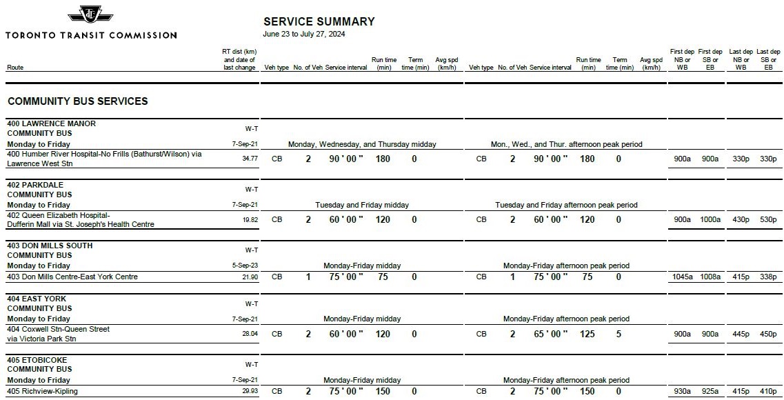
Community Buses
There is no change proposed for 403 Don Mills South. Also, the scope of changes to other routes is dictated by existing resources due to low ridership. There is no indication of what areas might benefit from expansion of the network, nor of the cost tradeoffs of new or improved Community Bus service versus WheelTrans, especially in an era when the TTC is trying to push riders onto the “conventional” system.
This is a classic example of “we can’t afford it so we won’t tell you” planning that has bedeviled TTC for years.
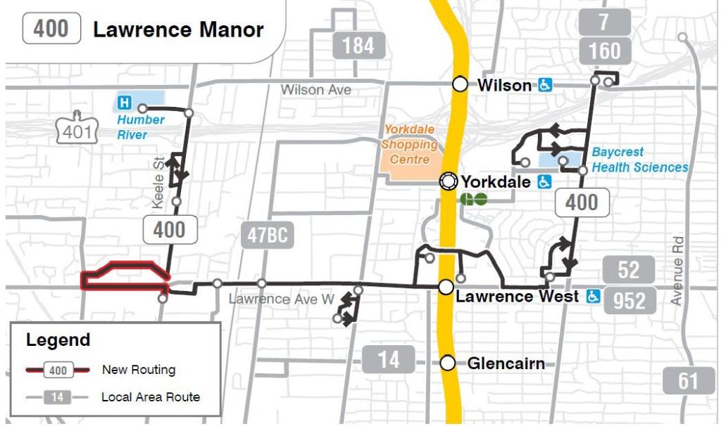
400 Lawrence Manor
The proposed extension would create a loop via Lawrence, Culford and Wyndale to serve Amesbury Sports Complex, Amesbury Park, and the Amesbury Park Toronto Public Library.
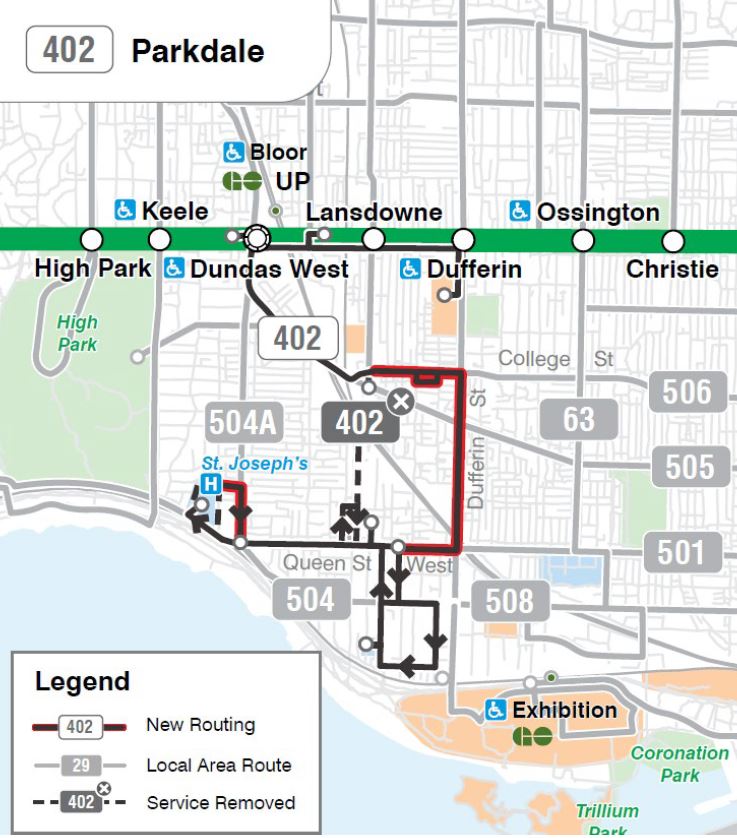
402 Parkdale
The route would be changed between College and Queen Streets to operate via Dufferin rather than via Lansdowne. Service around the loop via Macdonell would be removed. At Sunnyside, the loop would be expanded to the west side of St. Joseph’s Hospital returning east via Pearson to Roncesvalles rather than Sunnyside.
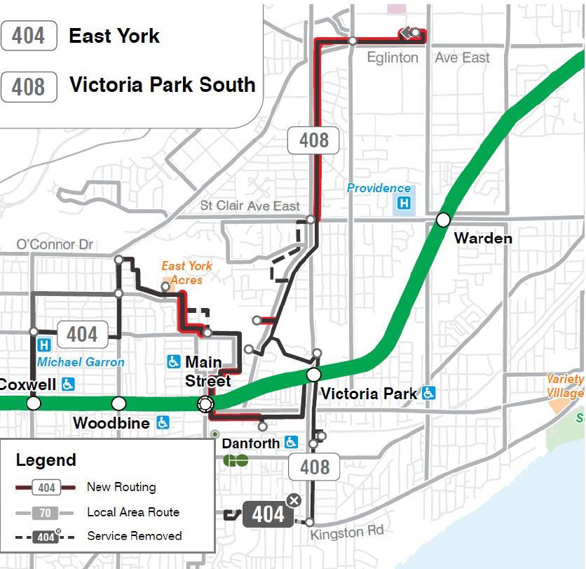
404 East York / 408 Victoria Park South
The existing 404 East York service would be split into two routes.
404 East York would operate via a revised route between Coxwell and Victoria Park Stations serving Main Street Station enroute. Service on Kingston Road west of Victoria Park would be removed.
408 Victoria Park South would operate from Bingham Loop at Kingston Road and Victoria Park to the Golden Mile on Eglinton looping at Warden. Service would be removed from the existing 404 loop south of St. Clair.
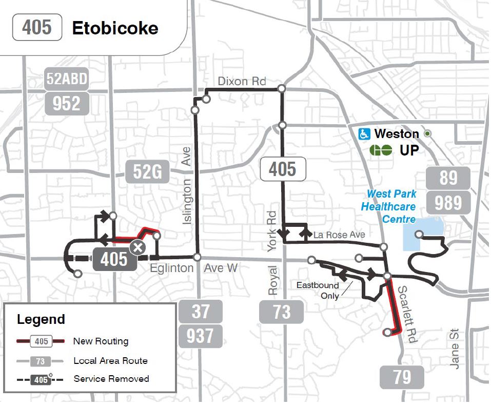
405 Etobicoke would be rerouted at its west end via Widdicombe Hill rather than Eglinton, and extended south on Scarlett Road to serve Lambton Square.
For reference, here is the current level of service provided on the Community Bus routes. This shows how paltry the existing resources are.
Construction Projects
The Plan discusses alternative service options for four major projects in 2025, but notably omits two that will have major effects on the streetcar network.
The TTC claims that plans for 2025 are influenced by “lessons learned” in 2024, but there no specific examples of what has happened.
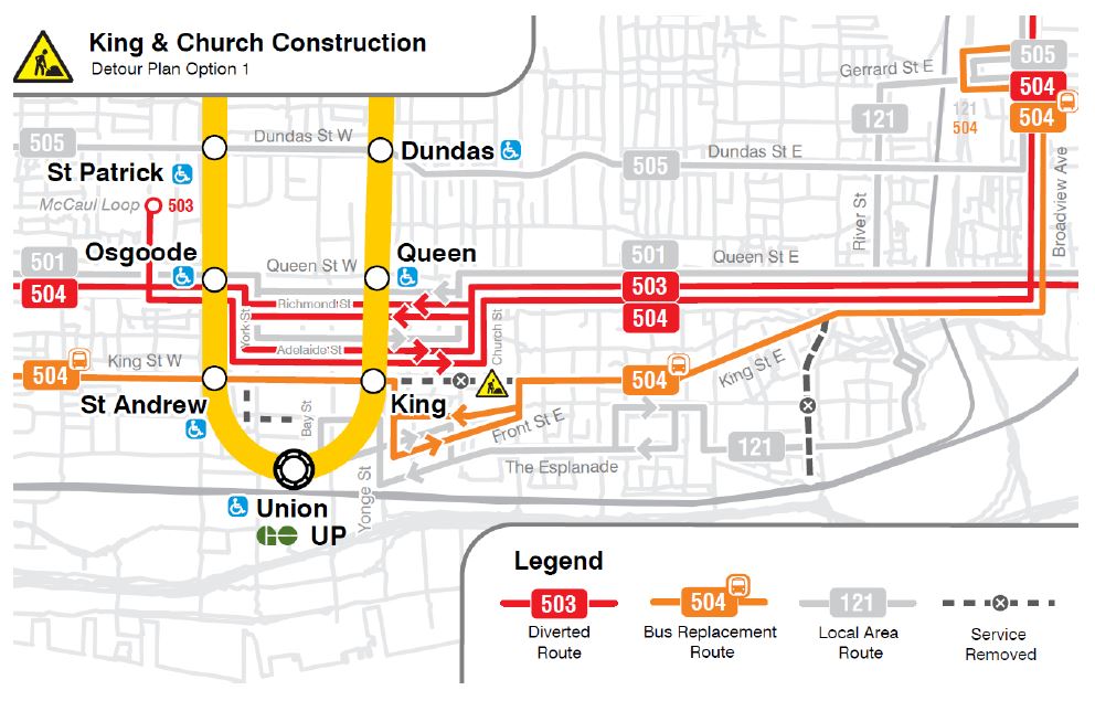
King-Church
Planned work at King and Church includes replacement of a City water main, reconstruction of the track, and overhead upgrades for full pantograph compliance. The overhead work will also extend east on King to near Queen at the Don River, and on the Distillery branch via Sumach and Cherry.
Proposed service alternatives completely remove service from King east of Yonge to at least Jarvis (option 1) or to the Don (option 2).
Common to both options:
- 503 Kingston Road service is rerouted to McCaul Loop from its usual downtown destination of York & Wellington.
- 504 King and 508 Lake Shore services operate via Queen between Broadview and Spadina, and then via King to the western end of their routes. 504 service to the Distillery is removed.
- All service in the Queen Street corridor will operate via the Church, Richmond/Adelaide and York diversion.
Option 1:
- Service on King would be provided by a 504 bus running east to Broadview and north to Gerrard (using the same route as the existing 501B Queen shuttle bus). 504 buses would divert around the construction zone via Jarvis, Wellington/Front and Yonge.
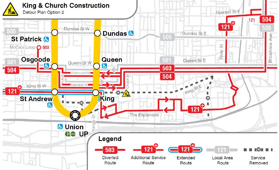
Option 2:
- The 121 Front-Esplanade would receive more frequent service and would be extended north via Yonge to King and then west on King to Spadina. There would be no service on King Street East and riders would use service on The Esplanade or Queen as an alternative.
Neither of these is particularly appetizing. Various concerns include:
- How long the project will take. Combined City/TTC projects like this have disrupted transit riding for months. This will put the City’s claim to accelerate work and get jobs finished quickly to the test.
- The plan does not include proposed start and end dates, nor does it discuss the interaction with other planned projects on King Street West (see below for details).
- The existing 121 bus is infrequent and not particularly reliable. Considerably better service will be needed as an alternative to the 504 streetcars.
- Construction at King Station on Yonge Street will pose a problem for service reliability.
- The 121 bus does not provide a direct connection to the Line 2 subway at Broadview Station. TTC claims that there is no room for such a service due to competition from other routes including the 25/925 Don Mills service rerouted from Pape Station.
- It is not clear that a Broadview Station to Distillery streetcar service would be impossible except for the period of overhead upgrades in the affected area. This should be timed to occur quickly and allow streetcar service restoration.
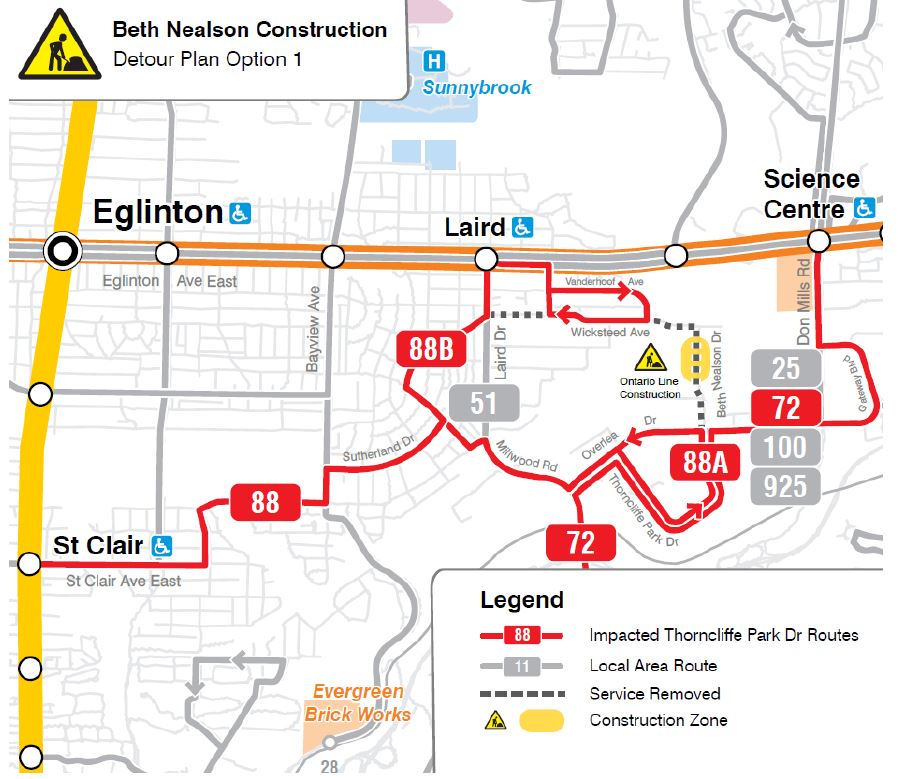
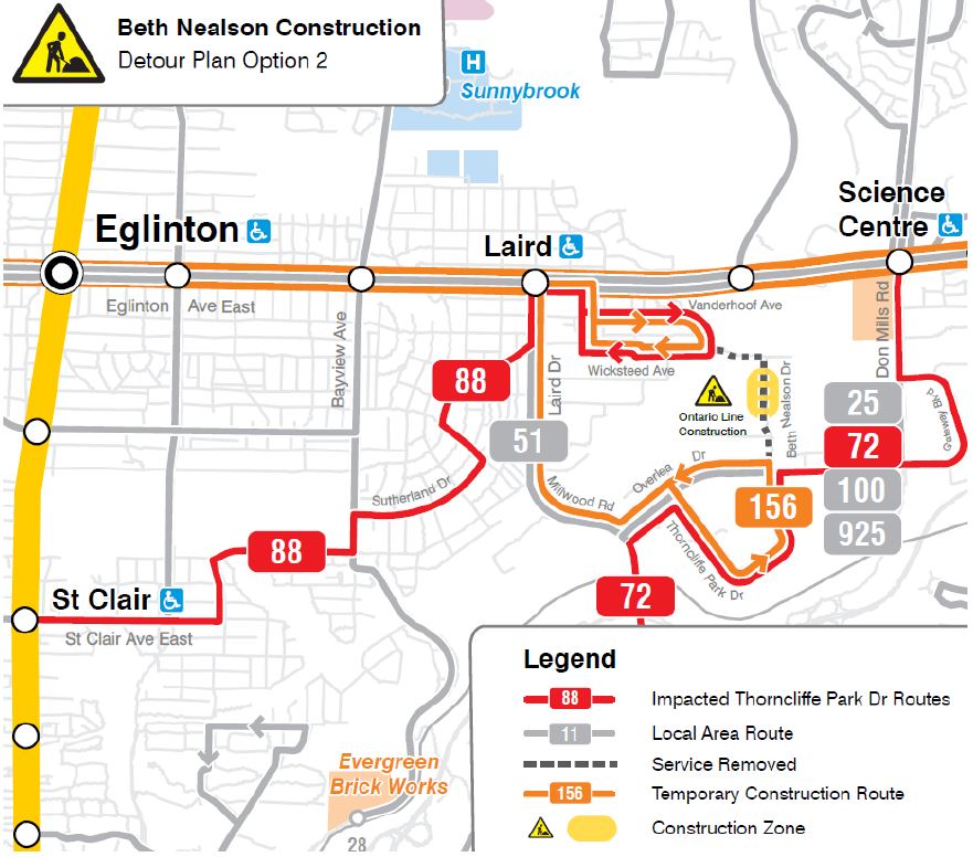
Beth Nealson
In 2025, Beth Nealson Drive which links Thorncliffe Park to the Leaside industrial area will close for Ontario Line construction. This will require a split in the existing loop of the 88 South Leaside service. There are two proposals for this change.
Option 1 creates loops for each branch, one in Thorncliffe Park (88A) and one at Eglinton connecting with the Laird Station on Line 5 (88B). Option 2 runs all 88 service to Eglinton and provides a separate route 156 from Thorncliffe Park to Laird Station.
Note that the map below reflects the route structure after Line 5’s opening with 72 Pape extended north to Science Centre Station and the consolidation of 56 Leaside into route 51 Leslie operating to Donlands Station.
A tradeoff between these options is that Option 1 maintains the link to St. Clair Station from Thorncliffe Park while Option 2 focuses north to Laird Station.
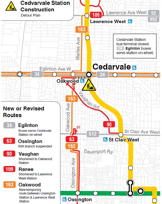
Eglinton West / Cedarvale Station
Eglinton West Station will be renamed “Cedarvale” as part of Line 5 opening. (This is a result of Metrolinx’ desire to eliminate duplicate or semi-duplicate station names.)
The bus loop requires repairs that will close it for service affecting many routes. The TTC proposes a service scheme similar to one used earlier in the Line 5 project, but adjusted for new station connections that will be available.
- Route 34 Eglinton (formerly 32 Eglinton West) will use on-street stops outside of the station.
- Route 63A Ossington to Eglinton will be suspended, and all service will terminate at St. Clair in Oakwood Loop.
- Route 163 Oakwood will operate from Ossington Station to Lawrence West Station replacing the 63A and the south end of 109 Ranee.
- Route 90 Vaughan will loop at Oakwood connecting with Line 5 at Oakwood Station.
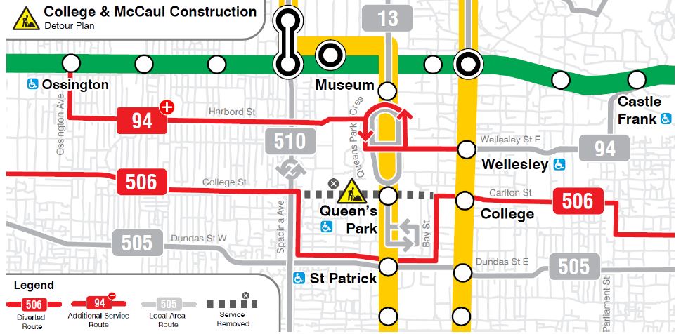
College/McCaul
Streetcar track will be replaced at the College & McCaul intersection. During this work, 506 Carlton cars will divert both ways via Bay, Dundas and Spadina, and there will be no service on College between Bay and Spadina. Service on 94 Wellesley will be improved to provide additional capacity in the area.
Note that the map shows 13 Avenue Road extending south to Gerrard, but the Service Plan proposes removal of this weekday daytime extension.
TOInview
The City maintains a consolidated project map at TOInview showing planned work on the road network. This includes three projects that are not included in the 2025 Service Plan:
- King Street West track and water main from Shaw to Bathurst
- King Street West track and water main from Dufferin to Close including the intersection at Dufferin
- College/Carlton overhead upgrades from Lansdowne to Parliament
I have asked the TTC for clarification on these projects and will update this article when info is available.
King Street West
Not included in the ASP is a planned project for water main and track replacement on King from Dufferin to Close in Parkdale. This is a continuation of the 2024 project, but no service details are provided. A TTC planner claimed that because this was a carry-over, the item was not included even though there are supposed to be “lessons learned” that might inform the plans.
Also missing is the planned track and water main replacement from Shaw to Bathurst.
There is no discussion of the timing of these projects relative to other events including the King/Church intersection work.
Much celebration accompanied the “early” completion of the work from Shaw to Dufferin a few weeks ago. What was not mentioned is that this was possible because a major component, the intersection reconstruction at King & Dufferin was moved from the 2024 to the 2025 plan. The work finished early primarily because the scope was reduced.
College/Carlton
TTC plans streetcar overhead upgrades on the 506 Carlton route from Lansdowne to Parliament in 2025, but this is not discussed in the ASP.
There are several opportunities for subdividing this project with a series of diversions around segments of the route, but it is not clear whether TTC will take advantage of this. Moreover, the timing of this work should obviously be co-ordinated with the track replacement at College & McCaul.
Mid-Block Stop Relocation
The Survey also includes questions about proposals to relocate transit stops based on the principles listed below.
We use the guiding principles below to review stops across the transit network in order to balance accessibility, pedestrian safety, customer convenience, community impacts, bus reliability and travel times:
- Locating transit stops as close as possible to crosswalks at signals, stop signs, and pedestrian crossovers.
- Maintaining reasonable access to key destinations like senior/nursing homes, schools, libraries, community centres, hospitals and shopping centres.
- Ensuring stops are placed at locations with adequate space for customer amenities and meeting accessibility requirements.
- Balancing the number of bus stops on a route to ensure customers have adequate transit access while also ensuring customers on-board have quick and comfortable journey times.
The first group of questions speaks to the distance to stops and the trade-off between additional walking time and the time saved by riders with buses stopping less often. The survey states:
Past studies have revealed that optimizing bus and streetcar stops (by moving, consolidating, or removing them) might add up to 3 minutes to some customers’ travel to a stop, but overall could save all customers on the route an average of 5 minutes on their trip.
This is a dishonest presentation of the issue because many stops could have to be removed for a time saving on average of 5 minutes per trip. No individual stop removal can achieve this. Moreover, some mid-block stops are less frequently used than those at major locations, and not all buses and streetcars stop at every mid-block stop. Moreover, there is a greater impediment to transit flow from the absence of transit signal priority than from a few extra stops along a route.
The second group asks about double stops where buses stop at both nearside and farside locations. The question is whether the convenience of two stops (typically to support easy transfer connections at wide intersections) is preferable to the extra travel delay for riders on board. There is no discussion of the relative lengths of time a single stop would take given that the boarding time now split between two stops would be consolidated, nor of traffic signal priority that would particularly benefit farside stops.
There is also a question about “single stops”, locations where there is a stop in only one direction. The implication is that these should be removed rather than providing the “missing” stop. The example shown is a mid-block stop, but there are cases where single stops exist at a traffic signal. The discussion also does not address street geometry which can affect stop placement.
The third group relates to amenities at stops and asks readers to rank their importance. It should be noted that some existing amenities are delivered under contract between the City and Astral Media whose interest is less in transit convenience than in marketing. TTC riders should not be held hostage to Astral’s spending and maintenance plans.
Finally, there is a demographic section.

In 2025 The Esplanade from Berkeley to Lower Jarvis will, again, be a bit of a construction site as the work on David Crombie Park is starting in spring 2025 and includes the installation of a proper, raised, bike track on south side of The Esplanade. If the 121 is supposed to be a replacement for the 504 this will need to occur after the work on The Esplanade is finished. (There are also a couple of Toronto Water projects in the area, including a new storm sewer on Princess (which is on the 121 route.) It all looks a bit ‘un-thought-out’!
Steve: In the consultation session, I had the sense that the interaction with other projects had not been given much thought.
LikeLike
It seems to me that the TTC cares far more about PR than being honest with customers, and that is particularly apparent with the King West project which was “finished early”. Little do customers know that service on that stretch of King could soon be removed again. Is there a reason why all the work on King wasn’t done at the same time?
Thanks so much for the updates on everything Steve! At least we can count on you to be transparent when the TTC isn’t.
Steve: The special work for the Dufferin intersection wasn’t ready, according to TTC, hence the delay. The work from west of Dufferin to Close was always projected for 2025.
LikeLike
I really think that break that disconnects The Esplanade from Mill Street needs to be restored, if only for transit. It made sense long ago when this area was largely vacant, but now it would facilitate a much needed and faster east-west bus route.
Steve: That area is a park, a bike path and the south end of the Corktown Station construction site. I don’t think this idea is worthwhile, especially considering the infrequent service on 121 Esplanade.
LikeLiked by 1 person
Has the TTC indicated what kind of frequency the 163 would be expected to run at?
Steve: No. Only the route layouts are shown in the plan.
LikeLike
The idea that “mid-block” stops can be removed is, I think, a pernicious one.
There are many routes in the suburbs where there is not a traffic light or (much more rarely) a crosswalk, for a kilometre or more. It’s 1090 metres from Kipling to Thirtieth along Horner (home of 110A and 110B). Evans is just a little less from Kipling to Treeview. These are just examples I can think of, locally, off-hand.
“Well you can walk another few hundred metres, what’s the big deal?” stop removal proponents argue. (Jarret Walker may take a similar line sometimes.) “But you will save time!”
What this ignores is how long it might take to walk from home just to the street that has transit. In my case, it’s 470m more or less, straight up the street, to the transit-carrying road (Lake Shore Blvd in this case). And there is a bus stop at the corner (but only for one direction of travel). However, should I want a streetcar, I have to walk either in the direction of travel for a total of 775m and then wait (in theory) for a pedestrian signal to access the platform, or walk against the direction of travel for a total of 680m or so, including two traffic signals.
Assuming an average walking speed of 1.4 m/s and an average delay at each signal of 25 seconds, that works out to 9.6 minutes to get to the downroute stop, and 8.9 minutes to the uproute stop.
At which point I am waiting for the streetcar, some random amount of time. “Just use an app,” some might say. As we have discussed here, TTC vehicles leave the loops with little regard to the schedule, so there is no way an app can give you a decent heads-up when you are close to the end of the line.
And here’s the problem. In the time that it certainly will take me to walk to the stop (because the closer mid-block stop was removed about ten years ago), I could have gotten in my car, and driven to the supermarket or library or wherever, and be shopping or reading already. Never mind how long the TTC vehicle will take to show up, and how many transfers I might have to make to get to my destination.
The people living in the suburbs may not use transit anyway, but those mid-block stops are notionally for them. Taking them away makes transit that much more inconvenient. This is the crowd to which Ford is playing with his congestion politics and bike lane demonization. Just wait, Ford is soon going to be coming for any kind of transit priority measures as well. And so it goes.
Steve: TTC has been pushing this stop removal program for years, although some attempts get pushback from local Councillors. There is great variation in the configuration of stops, streets and access paths to adjacent neighbourhoods, but this is presented as a one-size fits all argument on the grounds of travel time savings (bogus) and safety (very location dependent). If this were proposed as a question of stop review including relocations and additions where justified, the proposal might bear watching, but the intent seems to lean both to stop removal and changing the service standard to increase the target stop spacing. This is contrary to aims of accessibility and making transit attractive to riders.
LikeLiked by 1 person
The 35D Eglinton West Jane & Emmett bus (between Eglinton West Station and Jane & Emmett, looping clockwise way along Emmett) will be replaced by an extension of the 73B Royal York La Rose & Emmett bus (between Royal York Station and Mt. Dennis Station, running in both directions instead of one way), when the Line 5 opens… allegedly in 2025.
The 405 Etobicoke community bus currently also runs along La Rose & Emmett. I can see changes to the 405 community bus, but they may keep it to provide access to the front door of the West Park Healthcare Centre.
LikeLike
“Lessons learned” nothing was learned. Why run 3 major streetcar routes on one corridor? That’s just going to cause even more delays. It’s better to have the 504 bus run from Broadview station to Bathurst and streetcars from Dundas west to Charlotte.
LikeLike
How long is the Beth Nealson Drive closure supposed to last? Also, any word on how long the Don Mills buses will continue to be routed to Broadview Station for? Will it be for years until Pape Station construction is fully complete, or does it look like a permanent re-routing to Broadview Station. I do say it actually sounds better to be routed to Broadview because it offers a dual connection to Line 2 or the 504/505 cars into downtown – so when Line 2 is jam packed it actually can end up with no time difference taking either “tram” line into downtown as it is trying to get on the subway and waiting for 5 car-sets to pass before a successful to squeeze in during the morning rush if it is after 8:15AM.
Steve: Re Beth Nealson, I am not sure but would not be surprised if it’s a year at least as they have to build the OL crossing and grade separate Beth Nealson to go under it. A for Pape/Broadview, it was originally announced as ending this fall, but now it’s late 2025.
LikeLike
As a retired Bus Operator who spent many hours of my career on the 87 Cosburn route, I will say that most days the 87A branch was a waste of time considering that the 404 Community Bus services that location. The main issue from an operations standpoint is that the route loops in a private parking lot. This parking lot loop is a tight turn for a 40′ bus at the best of times. All it takes is one improperly or illegally parked vehicle in in parking lot or on Haldon Avenue and the bus cannot enter/exit the parking lot/loop. For the total number of passengers that actually use the stop at East York Acres – which is NOT accessible due to its width and the fact that it is sloped (Stop # 2228 – does not show accessible on TTC website), this is a waste of TTC resources. However, as an Operator, I was always told that this location was due to a previous East York Councillor “forcing” it due to a family member living there.
LikeLike
The plans for Cedarvale construction fail to consider the proposed 164 Castlefield route. Buses along that route are supposed to start and end at Cedarvale, one Line 5 service starts.
LikeLike