
Updated February 11, 2023 at 1:45 pm: In response to a reader comment, I have added illustrations from the City’s presentation deck showing the technologies used for traffic monitoring and analysis at the end of this article.
This article continues a series of reviews of operations on the King Street Transit Priority Lane of which the most recent is King Street Travel Times: May-December 2023.
On February 9, 2024, Mayor Chow held a press conference to announce various changes coming to King Street and the success of the Traffic Agent program in taming congestion downtown, particularly on King.
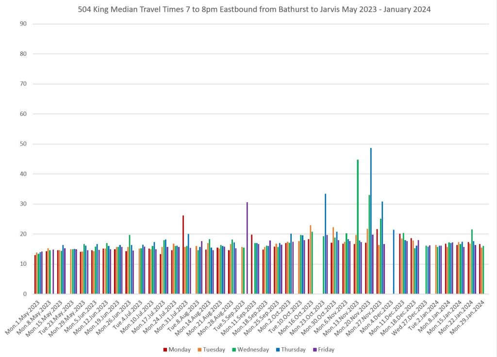
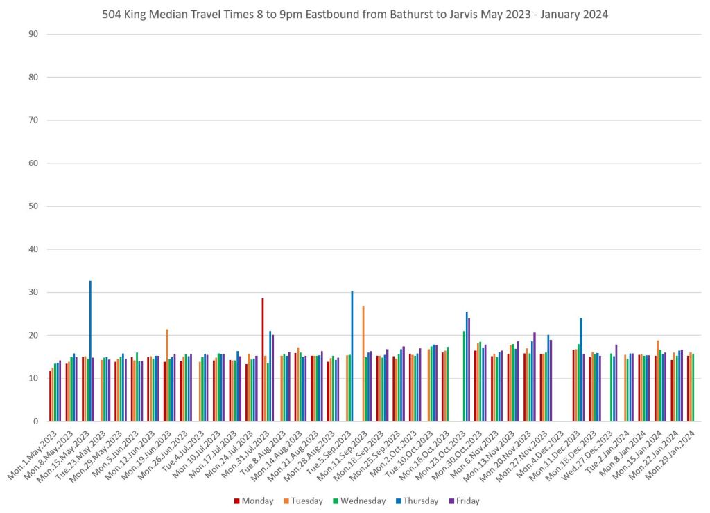
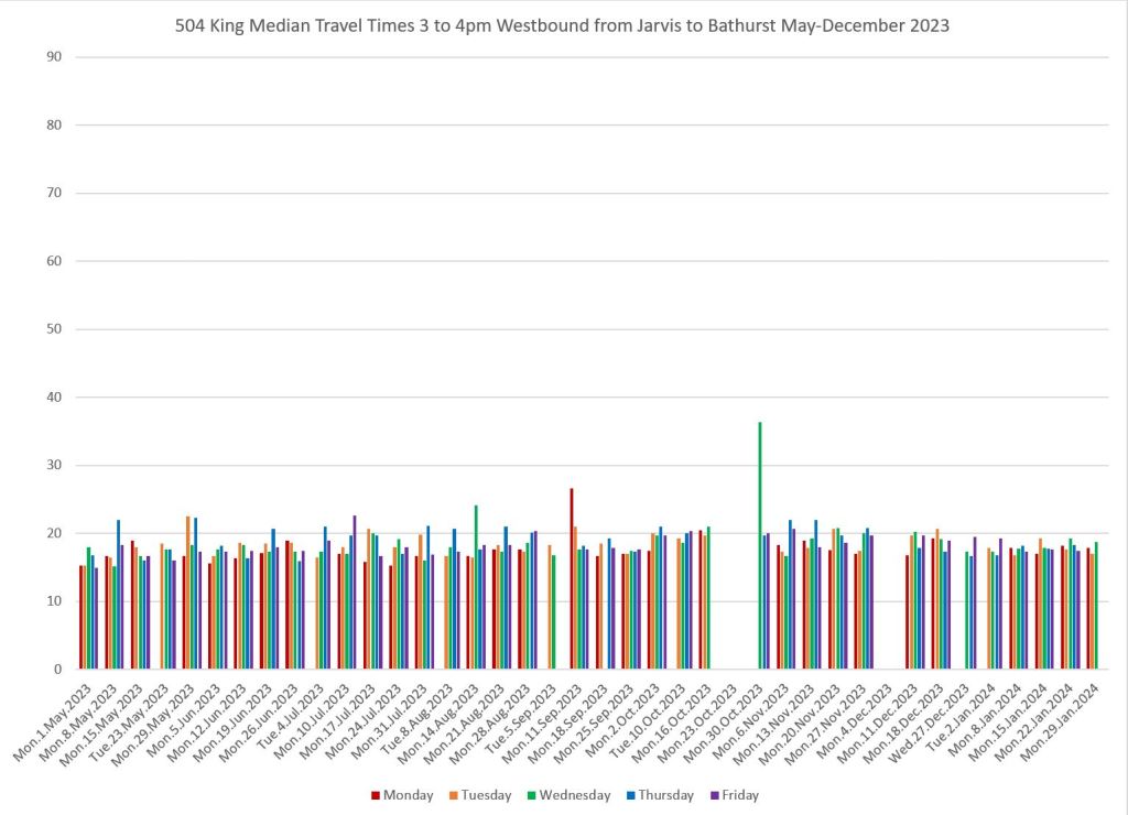
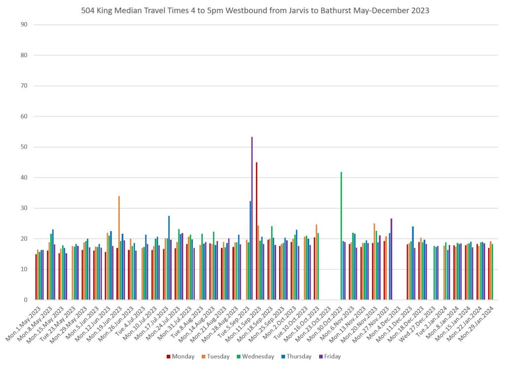
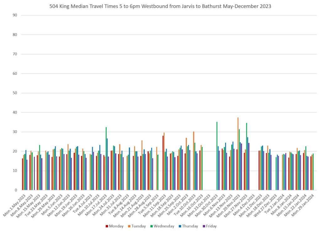
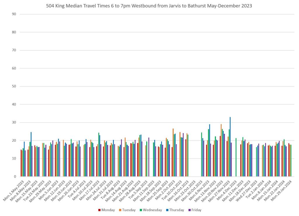
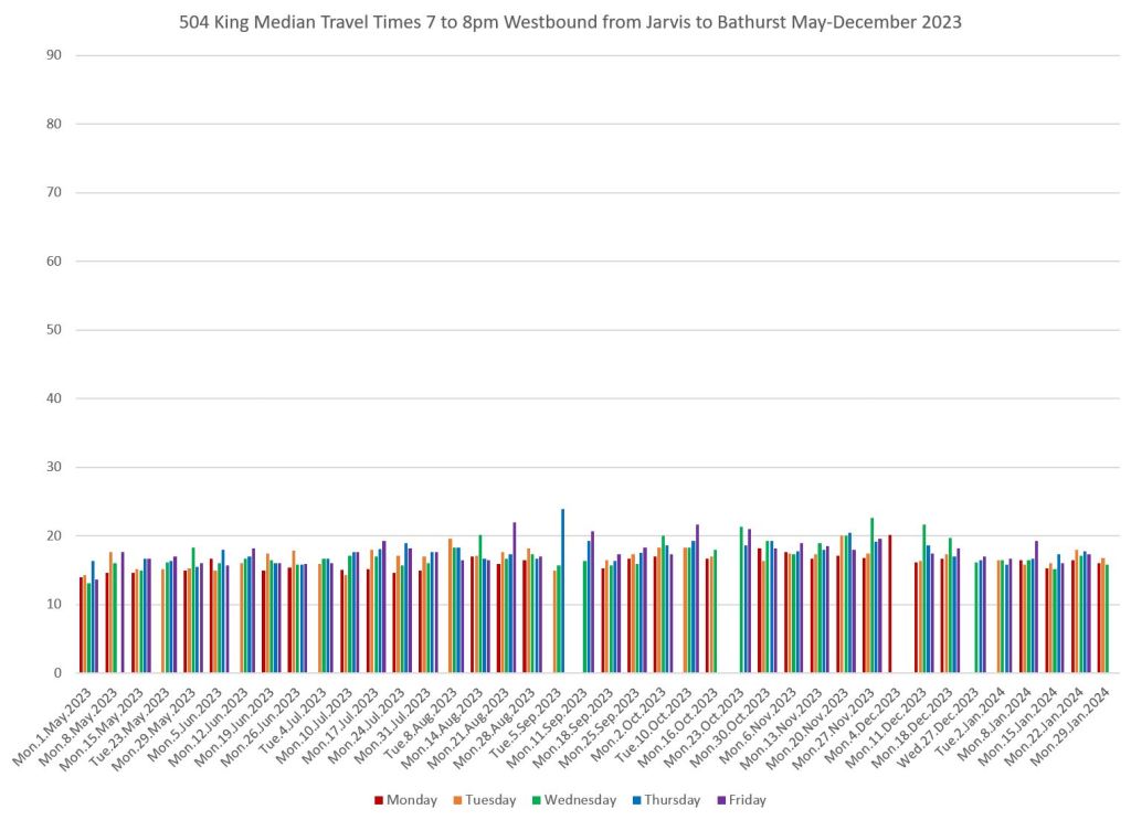
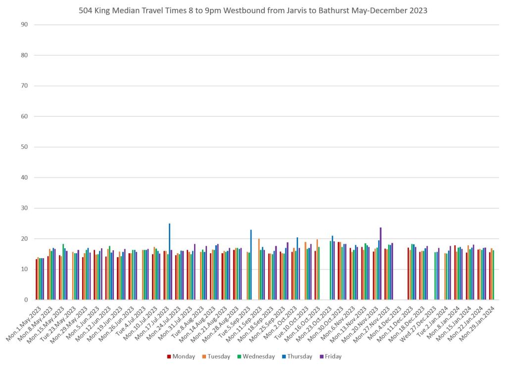
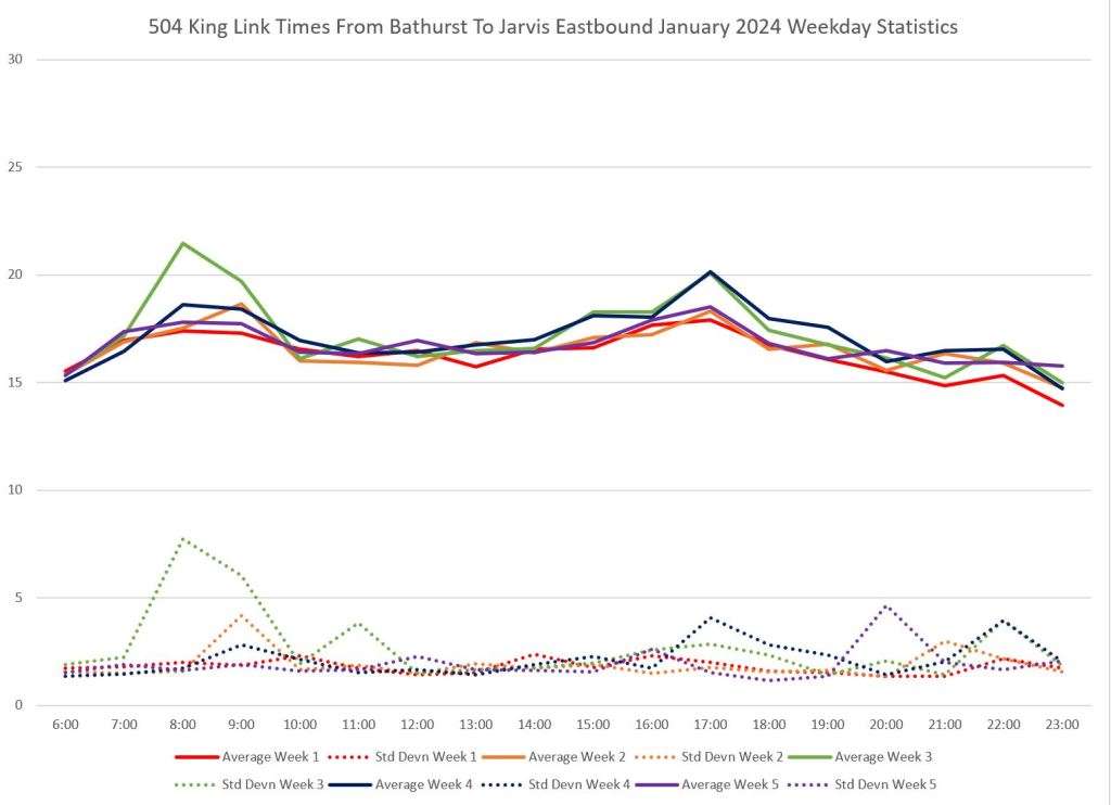
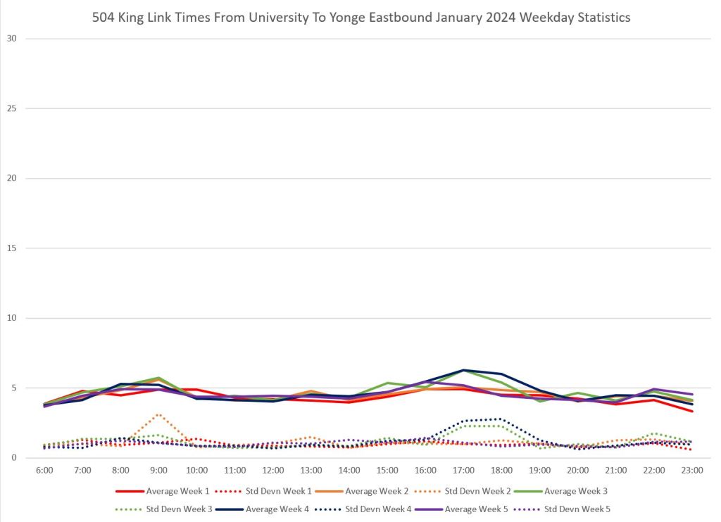
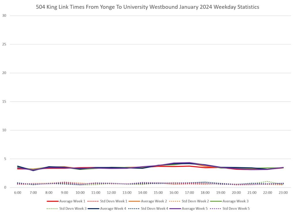
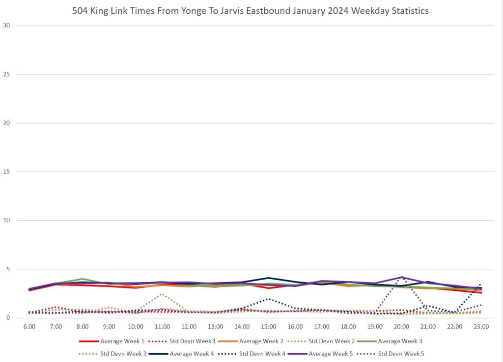
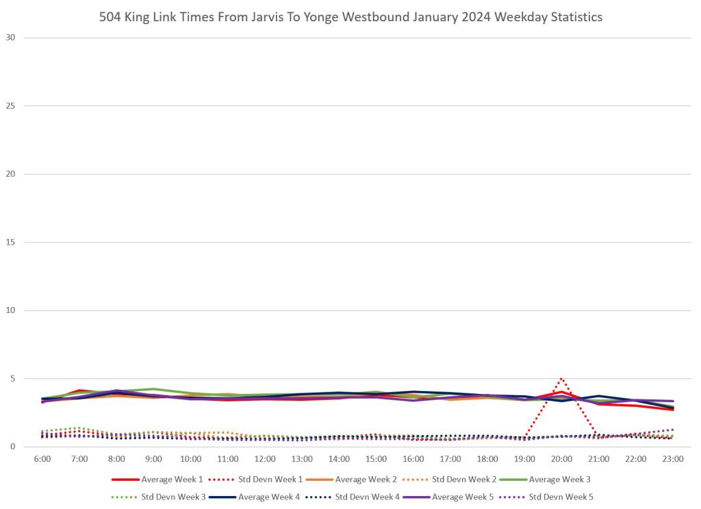
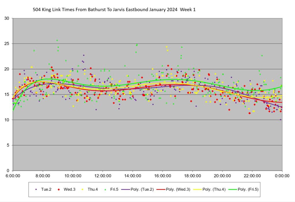
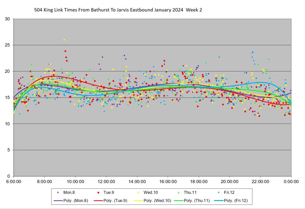
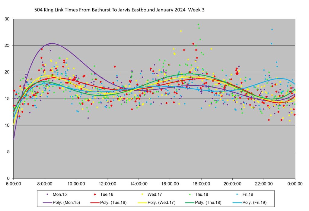
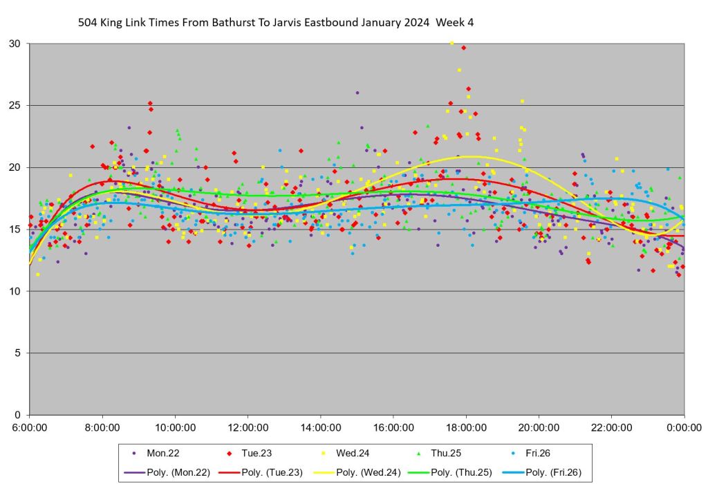
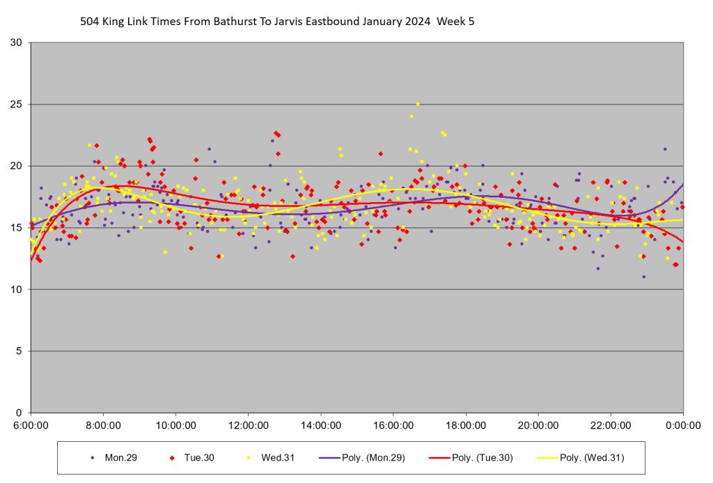
Regular readers will know the graphs below showing day by day travel times eastbound from Bathurst to Jarvis by hour from 3pm to 9pm. These charts have been updated with January 2024 data. (Note: Gaps in the charts in mid October and early December correspond to diversions via Church and Queen for water main repairs east of Jarvis. No streetcars covered the full Bathurst-Jarvis segment during these periods.)
The graphs illustrate the change in congestion levels peaking in the 5-6pm hour, but still quite evident in 6-7pm and to a small extent in 7-8pm. The build-up through the fall was caused by construction on Adelaide coupled with a complete lack of enforcement of the transit corridor and of “box blocking” at major intersections where cars enter but cannot cross in the allotted green time. With the introduction of Traffic Agents to enforce the rules on November 27, 2023, the street ran much more smoothly and the peak in congestion vanished.
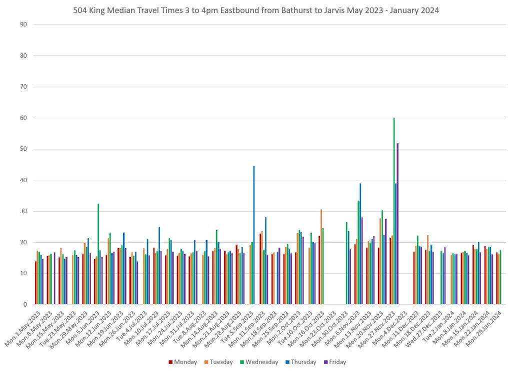
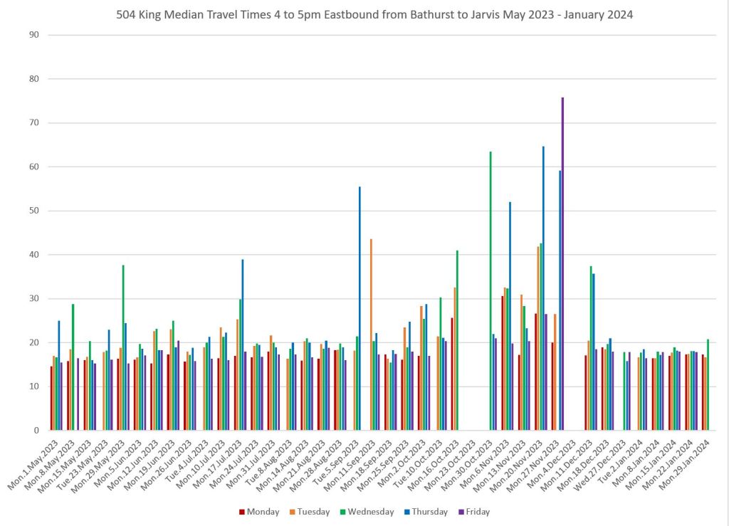
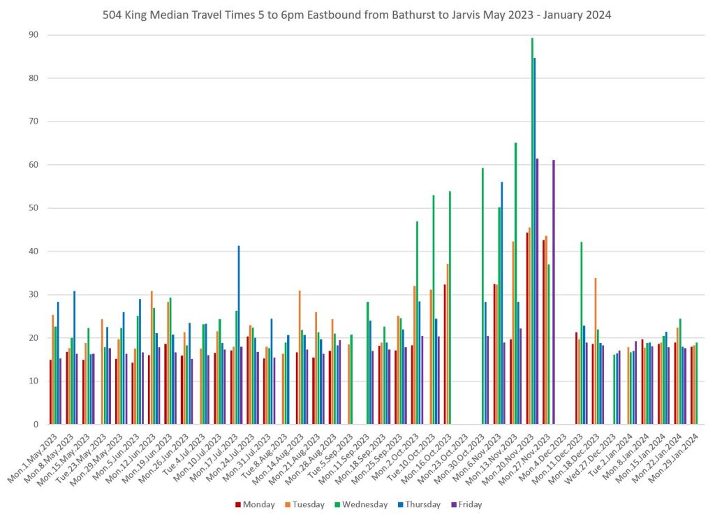
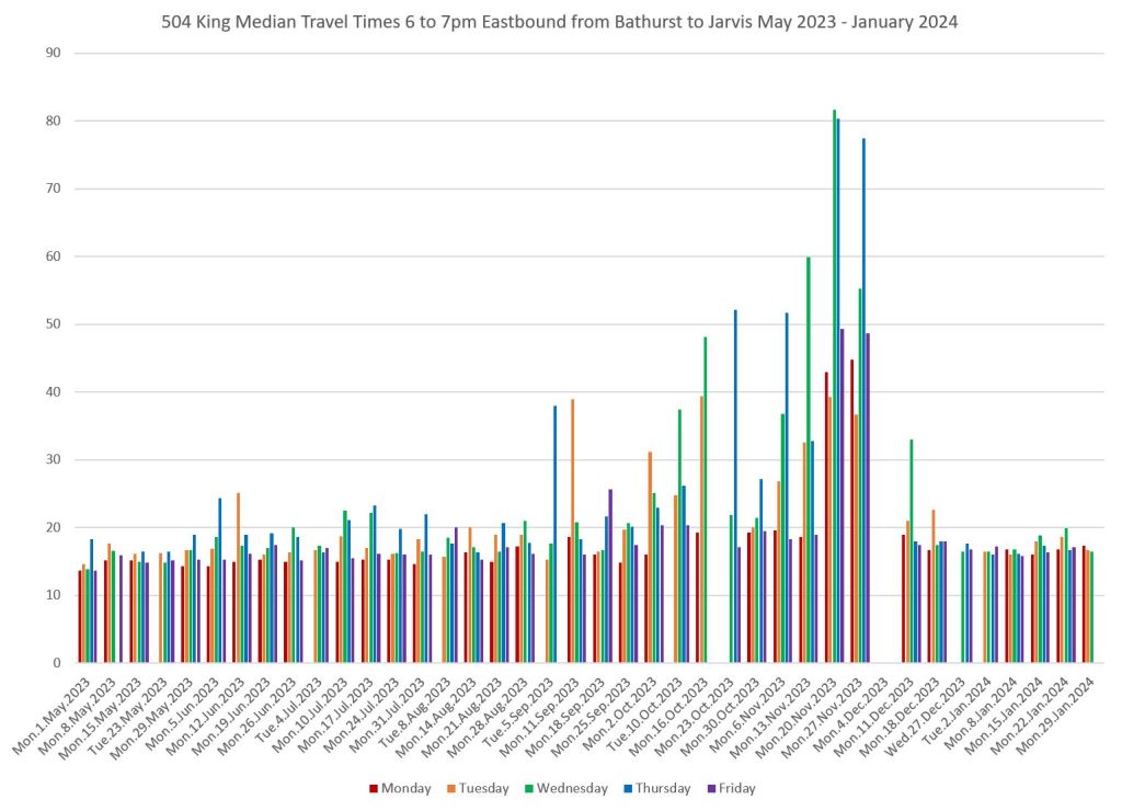
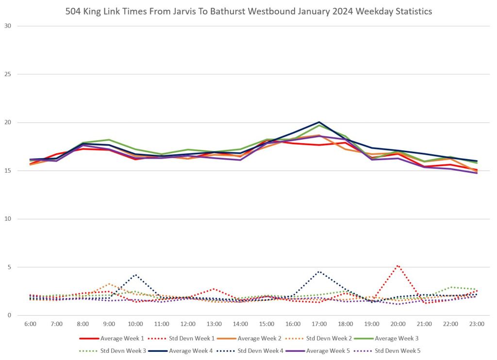
The problem was less severe westbound because Adelaide is one way eastbound and westbound traffic was not diverted. Moreover, there was no westbound equivalent of the delays caused by buses and streetcars making left turns eastbound at Church.
The uniformity of travel times in January is visible in all day charts. There are conventional AM and PM peaks, but they re fairly small. The standard deviation of the values is also generally small showing that individual trips fall within a narrow band of times. The largest peak (week 3, eastbound, 8am) was caused by a major delay and diversion on Monday, January 15. Because these are weekly averages, the effect of this delay is muted by averaging in with four other “normal” days.
The highest peaks are in weeks 3 and 4 when full traffic had returned after the New Year’s holiday. Week 5 has lower values because it includes only Monday-Wednesday January 29-31 and the values are dominated by the quieter early week conditions.
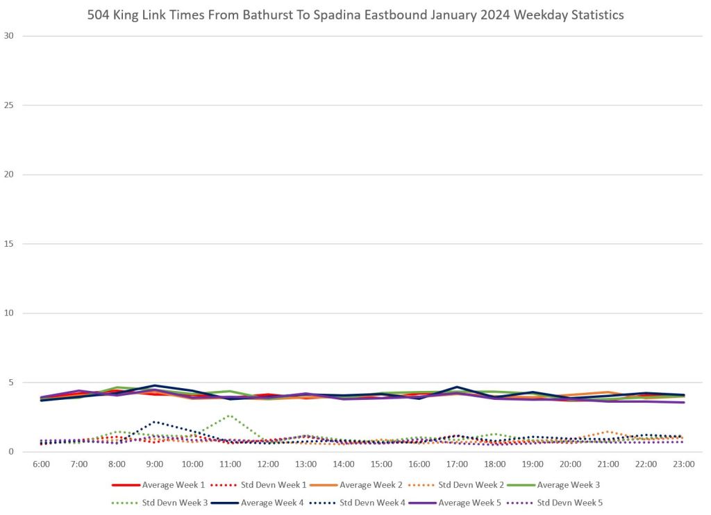
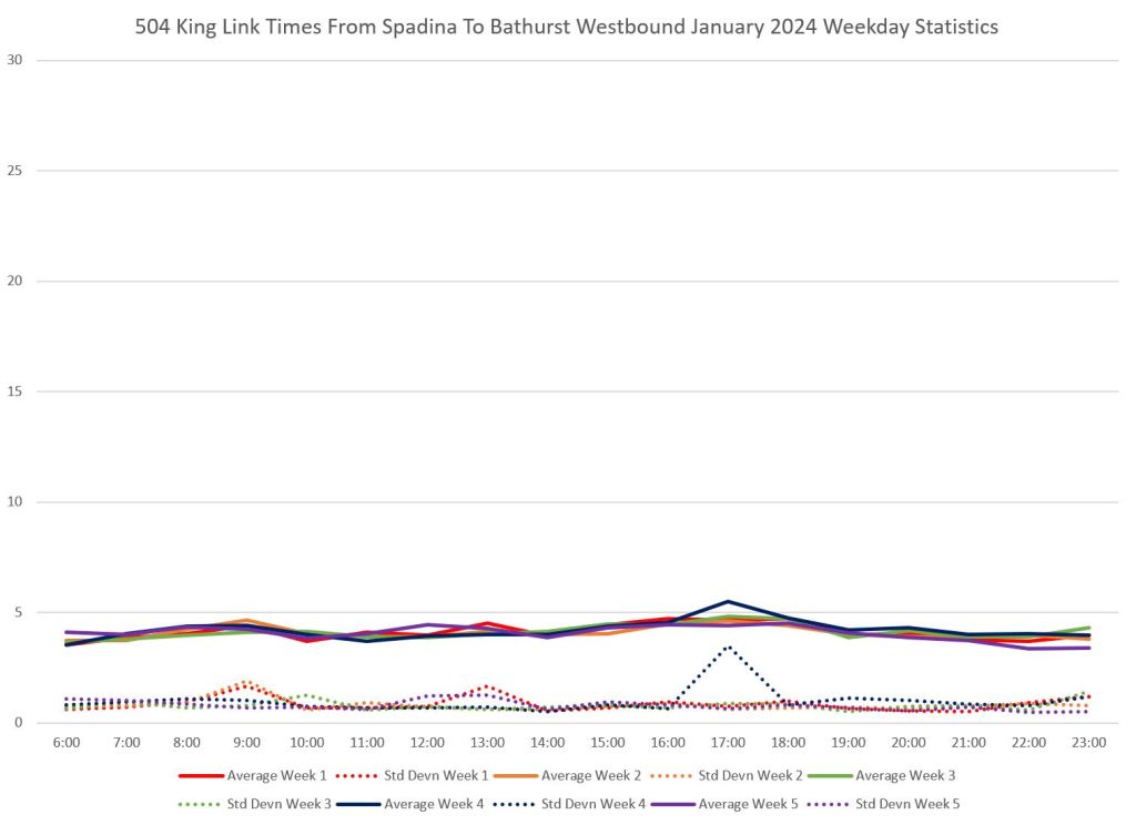
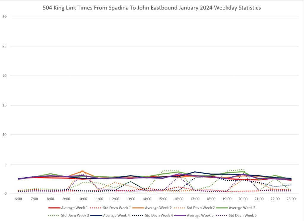
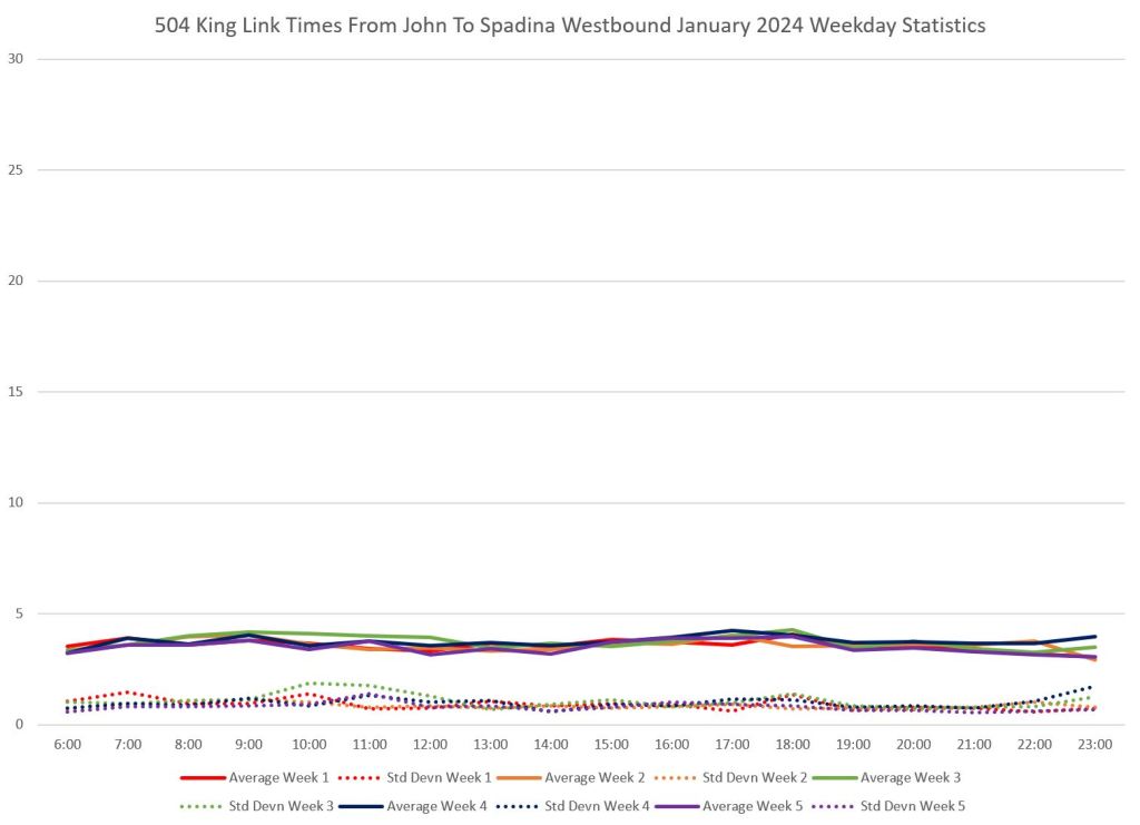
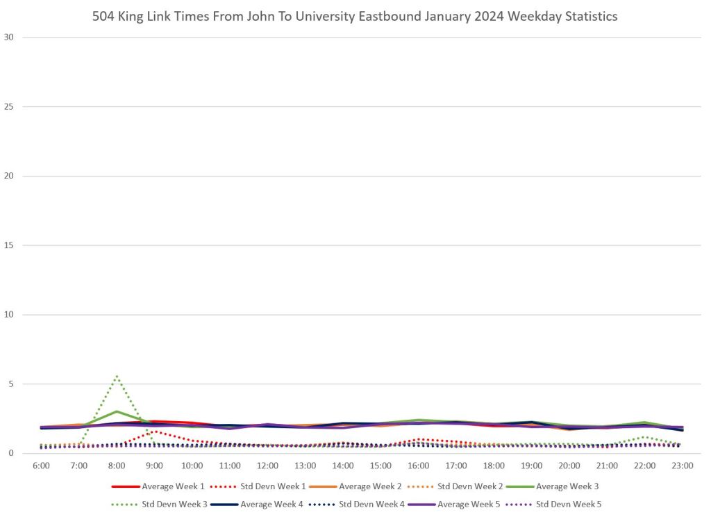
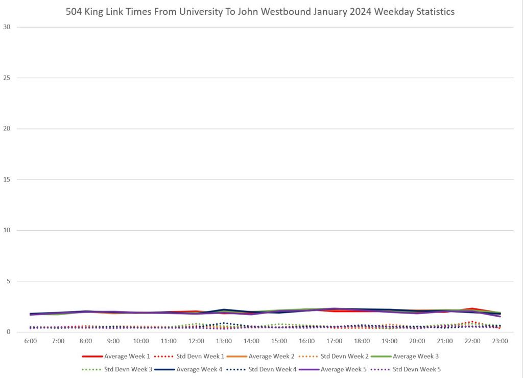
On a segment-by-segment basis, the locations of slowdowns, if any, are evident. Note that the segment charts can contain trips omitted from the overall charts above because streetcars can enter the transit corridor midway following a short turn. This is most pronounced eastbound from Spadina to John because the data include cars short turned via Spadina, Adelaide and Charlotte which took extended layovers on Charlotte awaiting their scheduled time. (Yes, gentle reader, there are short turns despite the TTC’s claim that they do not exist. They just don’t report many of them in their stats.)
Most of the rise in eastbound peak period travel times is in the University-to-Yonge segment.
The detailed level view of day-to-day variations is shown in the following charts. Of particular note are the higher values on the shoulders of the peak periods especially after 6pm.
Mayor Chow’s Press Conference
The presentation deck accompanying the Mayor’s press conference illustrated several points about King Street and the Traffic Agent program.
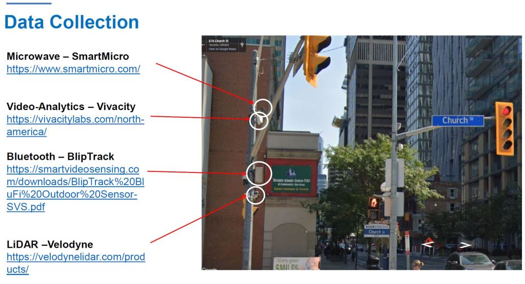
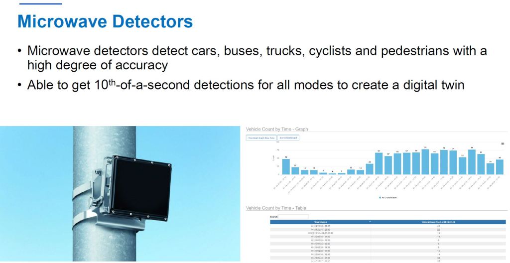
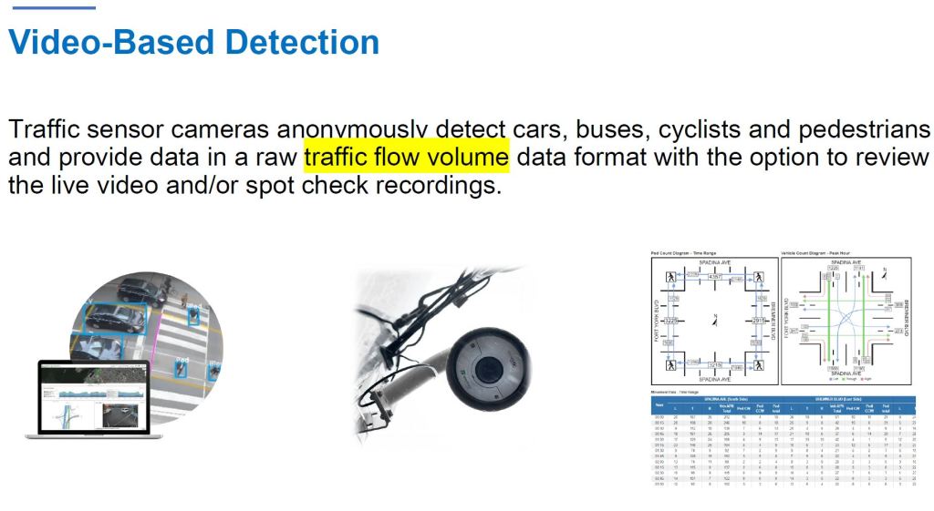
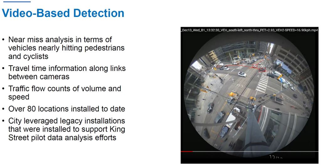
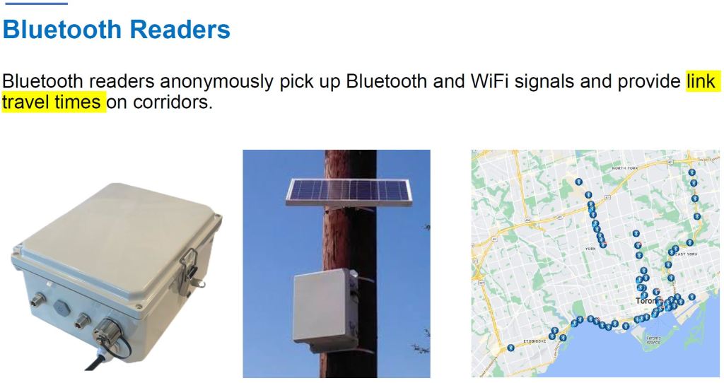
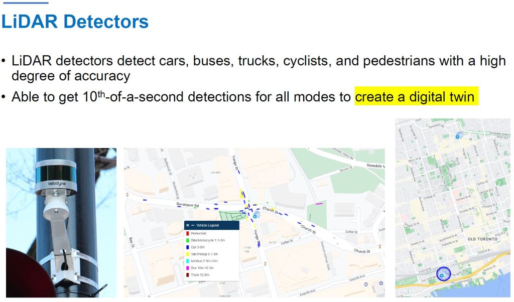
The City uses a variety of techniques to monitor traffic movements at a very granular level for car, transit, cyclist and pedestrian data, and this is archived for analysis. Detection includes video, bluetooth readers (tracking device movement, and by implication people on foot or in vehicles carrying them), LiDar and Microwave. All data are anonymized. This allows examination of a street’s behaviour in great detail.
Two notoriously congested intersections benefited greatly from having Traffic Agents.
| Bay & Front | York & Bremner | |
|---|---|---|
| Reduction in vehicles blocking the intersection | 64% | 53% |
| Reduction in travel time for vehicles | 33% | 38% |
| Increase in traffic flow | 25% | 14% |
Notable by their absence are stats for pedestrians and cyclists. The early stages of the Traffic Agent program addressed auto congestion, and the co-existence with other road users is an important policy issue that will also affect King Street where the clear priority is for transit vehicles.
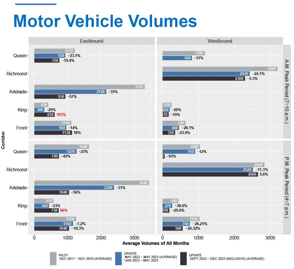
The volume of auto traffic is illustrated in stats collected by the City. Each quadrant of this chart represents a direction and time period, and the bars within the quadrants show traffic volumes crossing Bay Street on the east-west corridors. Various points of note:
- Adelaide Street carries a much larger volume of eastbound traffic, and Richmond handles a corresponding volume westbound. The capacity of Adelaide, and hence the traffic volume, was very substantially reduced in fall 2023. These are both very auto-oriented streets.
- These values are averages from several months and therefore the decline in capacity month-by-month through the fall of 2023 is not fully reflected.
- Eastbound volume on King rose above pre-pandemic values in fall 2023.
- Overall crossings of Bay Street declined by 28% compared to the previous year.
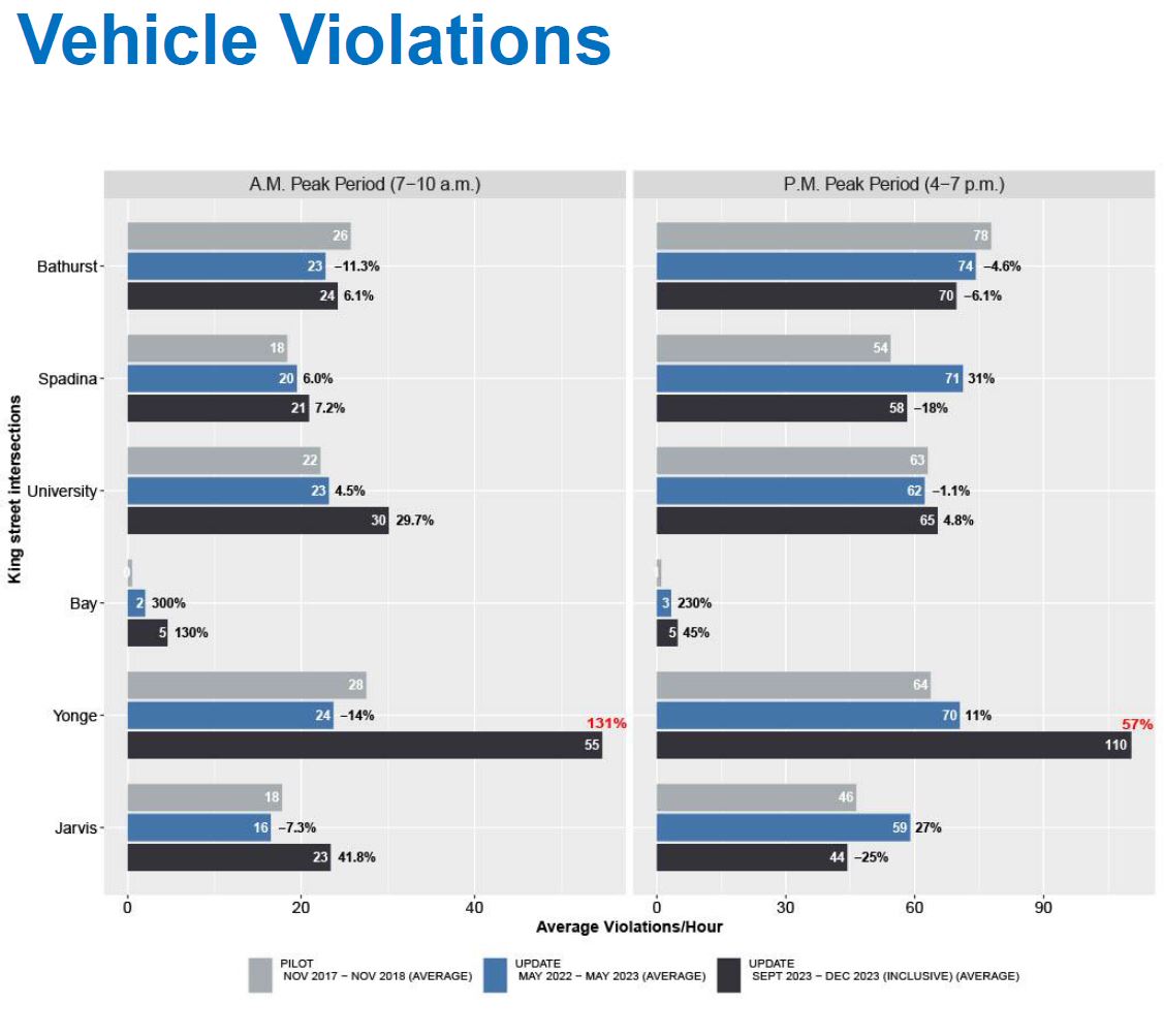
Violations of the traffic regulations along the King Street corridor have become a very serious problem at Yonge Street and to a lesser extent at some other locations. Traffic Agents prevent the banned movements, and in time, motorists might avoid King Street knowing that they will be forced to obey the rules, a practice that has been absent for a long time.
The City’s data tracking King Street travel times echoes my charts above. Note that this is for all vehicles, not just 504 King streetcars.
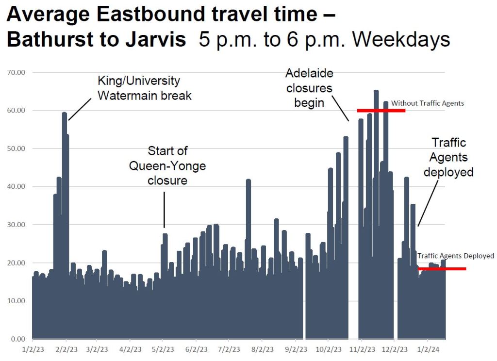
The benefit of the Traffic Agents is quite evident, although the ratio of travel times will probably improve once Adelaide fully reopens, and some transit traffic (501 Queen streetcars and buses) is removed from King. The timing of this change is unknown, although the current construction schedules do not show work on the streetcar diversion finishing until Fall 2024 thanks to Metrolinx delays.
The City’s observations about shoulder peak congestion mirror the travel time data in my own charts showing a rise in travel times after 6pm. They are considering a change to the hours of Traffic Agent coverage.
An important change still in the design stage will be to modify traffic signals to be more effective in getting motorists to follow the rules. This would involve, at a minimum, separate signals for transit and other traffic clearly giving transit a green through intersection while presenting motorists with a constant red signal and green arrows only for the allowed turns.
That scheme raises a few questions about groups that have special exemptions:
- Cyclists are allowed to travel through intersections where motorists are not. They will require a signal indicating what they can do.
- Taxis are supposed to only drive through between 10pm and 5am, and ride share vehicles are not included in this exemption.
We already know what intersections on Spadina look like with their multiple transit, motorist and pedestrian signals, and cycling signals would add yet another layer.
As for taxis and ride shares, the question arises of whether the through-movement restrictions would have to vanish for all motorists to avoid confusion about who could run through a red light.
Council has just approved a change to the handling of traffic violation tickets to speed and simplify processing. This will allow for, among other things, an increase in red light violations from automated ticketing.
Traffic signal timings have been adjusted to benefit transit vehicles, but the details are not in the presentation. Moreover, the timing of the changes could have co-incided with the Traffic Agent deployment, and specific effects would be hard to tease out of the data.
The condition of platforms at stops has been a disgrace for several years thanks to lack of maintenance and the relocation of some stops to suit condo construction zones. The City plans to implement 20 new temporary platforms beginning in mid 2024. Full reconstruction of King including sidewalk extensions is still in the future and is unlikely to occur while Queen is under construction for the Ontario Line. Meanwhile a Spring cleanup will deal with some condition problems as a short term improvement.
A detailed report will come to Council in the second quarter of 2024.
Illustrations from the City’s presentation courtesy of Mayor Chow’s office by way of Matt Elliott.
Traffic Sensors Used by the City
This section was added on February 11, 2024, in response to a reader’s comment.
Various sensors are used by the City to monitor traffic and provide both real time and archival stats for analysis. I had omitted this part of the City’s presentation from my original article.

When is the York-Adelaide-church track opening for queen streetcars?
Steve: Fall sometime thanks to much foot-dragging by Metrolinx who are responsible for the York Street segment.
LikeLiked by 2 people
Wonder what would happen WHEN we return Adelaide and Richmond back to being two-way streets?
Adelaide and Richmond became one-way streets in 1958, efficiently becoming mini-expressways funnelling into and out of the Don Valley Parkway. Businesses along Adelaide and Richmond were affected to the negative, losing business.
LikeLike
Maybe because I see it far more often as I live at the east side of the “Transit Corridor”, I would say that there were also very serious problems at King & Jarvis due to vehicles backing up from Lake Shore and the Gardiner. The traffic Agents (whose jobs seem quite dangerous and really cannot be fun) have made a HUGE difference and King is usually kept clear at Jarvis.
On a tangent: I gather that our local BIA is starting to agitate again about moving the priority corridor east as far as Parliament and (with the Ontario Line station) creating a ’transit plaza’ at Parliament. From my non-scientific observation traffic volumes east of Jarvis seem to have declined already and this sounds reasonable – and there are no private garages with entrances off King in the Jarvis to Parliament blocks.
LikeLiked by 1 person
Perhaps I’m partial Neanderthal, but just scanning through the in-depth analysis, this astounded me as per “Bluetooth”.
Googling, I see it’s a ‘thing’:
Bluetooth_Sensors_for_Vehicular_Traffic_Monitoring
Steve: Trackable devices have been used for years to monitor traffic flows. With the vast number of cell phones, this is quite easy.
LikeLiked by 1 person
I have seen the Traffic Agents in action eastbound at Yonge forcing cars to turn south instead of allowing them to go through the intersection. If this becomes a permanent solution all along the corridor at least at rush hours it will be of huge benefit to transit riders.
Traffic along Adelaide isn’t as bad as it used to be. I think motorists maybe avoiding it due to continuing construction or perhaps choosing not to drive downtown as much due to construction.
LikeLiked by 1 person
Won’t you look at that, when the transit priority rules are enforced, the thing actually works. A bit of snark because we all knew this to be the case.
The trick will be in rebuilding King Street so that its design is self enforcing. If we need police on site 24/7, then the street design has failed. Alternating one ways that are a dead end at every block is self enforcing. I hope they consider it.
A redesign of King Street was said to be coming with track replacement in 2023 (?) but that never materialized. Did Tory just drop the ball or is there another delay at play, perhaps related to all the other road disruption downtown?
Steve: Partly it was kicking a major project down the road, so to speak, and now the conflict with Queen Street and Ontario Line construction. I suspect that Tory, who really had to be convinced to implement King Street at the time, was lukewarm on a permanent redesign.
LikeLiked by 1 person
The changes to King’s traffic signals are quite interesting.
I know the city has been implementing LPI’s [Leading Pedestrian Indications] throughout the major intersections, but for those with cycle signals, as far as I’m aware of, I haven’t seen any LBI’s used in conjunction with pedestrians.
As for the streetcar signals, I wonder if they’ll implement TSP’s along the route. I believe St.Clair (and Spadina, too?) had TSP, but it was deactivated for some reason. Does King have the necessary infrastructure for TSP?
Thank again for the article, it’s a very interesting read, as always.
Steve: King Street has TSP but it is only active at minor crossings such as Simcoe and John Streets. St. Clair has TSP, but of course with the current bus operation it is inactive. Like King, it is not enabled at major intersections. Spadina has TSP only for turning movements, and there it depends on the electric switches to “tell” the traffic signal that a transit only white bar is needed. If the electric switching is out of service and the switch is thrown manually, there is no transit phase.
There is no TSP for turns onto Spadina, only off of Spadina. This is in part due to intersection geometry where the electric switch antenna for left turns is inside the intersection, beyond the stop bar, and so the switch is not thrown until after a streetcar enters the intersection. That is too late for a TSP request.
LikeLiked by 2 people
As another partial Neanderthal (commenting on Stephen Saines), I get the concept (illustrated in his link) but where are the sensors and what do they look like? What would I see if I’m walking along the street?
Steve: I have added illustrations from the City’s presentation deck to the end of the article.
LikeLiked by 1 person
These Traffic Agents are … human, yes? So a better headline for TTC might be “Application of ‘HI’ speeds travelers” …
LikeLike
There are other streetcar right-of-ways that need improvement. (Honourable mention for the light-rail right-of-ways and bus lane right-of-ways.)
Start with The Queensway. Followed by Spadina Avenue. We will give more time for St. Clair Avenue West, until they complete the street widening under the railway between Keele Street and Old Weston Road.
LikeLiked by 1 person
Further to the Bluetooth measuring source: I’m an electronic tech, although RF (radio frequency) isn’t my specialty, I understand the subject….and yet I’m still taken aback at the proclivity to assay Bluetooth signals as vehicle number counts. (And that will include pedestrians using Bluetooth devices).
It’s not the technical ability to do it that astounds me so much (It makes perfect sense in terms of it’s widespread use since many individuals won’t be putting out full RF strength signals) (wireless headphones, etc) but it’s the *social* aspect of measuring something that is a personal device, even more so than cell-phones, which also could be, and in prior years were, measured as per traffic patterns.
As well as ‘Bluesnarfing’ and ‘Bluesniping’ being legally dubious, even when tracking is ‘anonymous’, I have to question the statistical accuracy of the gathered figures.
Study, although five years dated, here:
Evaluating the Accuracy of Bluetooth-Based Travel Time on Arterial Roads: A Case Study of Perth, Western Australia
LikeLike
We already know what intersections on Spadina look like with their multiple transit, motorist and pedestrian signals, and cycling signals would add yet another layer.
I’m not sure if you’ve seen this yet, but on eastbound Adelaide at Church they have now set this up and have both the regular car signals, transit signals, and cycling signals, I guess installed for a future where the streetcars will be on detour and have to turn across the newly-moved bike lane on the north side. It looks a ridiculous mess.
Steve: I will have to visit this and take photos to add to the article. Thanks for the tip!
LikeLike
Wow! I had no idea!
LikeLike
Ahmed writes:
One of the contributors to Urban Toronto forums years back with the nom de guerre of ‘Reaper Express’ worked on the team responsible for them. He claimed that (gist) “They could be turned on, but a decision has been made not to”. This was some five years back. I’ve tried to locate our email communications on the matter, but I can’t locate at this time.
What I have found is this:
Steve: Thanks for the link!
LikeLiked by 1 person
Since we all appear to be packing a touch of Neanderthal DNA, I think it’s time to cease confusing Neanderthals with the ‘quality’ of operation of Metrolinx, Bluetooth complexities, John Tory’s ability to conceptualize and the TTC commissioners’ understanding of their role as TTC commissioners.
I’m reasonably confident that, if we supplied a group of 100% Neanderthals with today’s knowledge and equipment, they would do better, because they would TRY to do better!
LikeLike
Some things that could improve things:
There is a parking lot exit east of York, it has an alternate exit on Wellington…it would be good to shut it from 4-7pm, it dumps cars onto King going east where they get stuck at Bay…there is no point in this, since they can’t go left or straight at Bay – meaning they can only go south…back to Wellington…
Improved queuing at king streetcar stops downtown, stanchions and people helping get people on and off cars seems like a no brainer.
Implementing standardized transit signals similar to what is used in Europe, Waterloo and in a few places on the Toronto bus network…white bars…
LikeLike