
Updated April 7, 2022 at 9:45 am: Metrolinx has responded to a query about possible errors and inconsistencies in the EA. See the Errata section at the end of this article.
The Draft Environmental Assessment for the Ontario Line was published on February 7, and it is a very, very long read. In addition to the main report, there are appendices dealing with Natural Environment, Heritage, Archaeology, Socio-Economics and Land Use, Air Quality, Noise and Vibration, and Transportation and Traffic.
In this article, I will primarily review the alignment drawings provided in the EA and some of the information about station form and construction, to the extent that Metrolinx has provided this.
Notable by their absence from these documents are drawings of the actual structures above or below ground. This makes it almost impossible to assess, for example, the on street presence of the elevated structure between the north end of the Leaside Bridge and Science Centre Station, nor of new station buildings wherever the line is above ground. Underground structures, essential to an understanding of how the stations will connect to neighbouring buildings and to other transit lines, are also not shown.
I wrote to Metrolinx asking about this, and they initially referred me to the Neighbourhood Updates segment of their engagement website. There is less information there, in most cases, than in the EA or other already-public presentations (which could be out of date). I wrote again, and they replied:
Hi Steve – those additional images will be posted as soon as they are available.
We know folks are anxious to see those images and we are working to get that information available.
It is baffling how people are supposed to assess information in the EA if they cannot see what Metrolinx proposes to build.
On a similar note, there is a general problem along the line in that significant incursions on green space have yet to be detailed, and by the time the plans are actually published, it will be impossible to adjust the design. Metrolinx misled communities giving the impression that tree inventories and replacement plans would be available during the consultation period, but it is now clear that this was never going to be the case.
For additional background, please see my recent article An Ontario Line Tour and the associated webinar.
In future articles I will turn in more detail to issues such as Natural Environment, Noise & Vibration and the effects on buildings and structures along the route.
Exhibition Station and Fort York
Exhibition Station lies north of the Gardiner Expressway, and is a substantial expansion of the existing GO Station. It will include a concourse level over the tracks (illustrations are in the Tour), and the platforms will be configured so that there is full interchange between four GO Lakeshore West tracks and the two Ontario Line tracks.
There are crossovers east and west of the station platform and tail tracks extending west to Dufferin Street. These provide both for train storage and potential future extension.
Not shown in this drawing are revisions to the streetcar loop now used by 511 Bathurst and 509 Harbourfront streetcars which is immediately south of the GO corridor. There are plans underway, now in the design stage, to extend streetcar trackage west to Dufferin Street. Work on this project is “on hold pending evaluation of Ontario Line impact” [TTC Transit Network Expansion Update, February 10, 2022, at p 7].
If the streetcar stop at Exhibition becomes a “line” station rather than a terminal, arrangements for separate westbound and eastbound platforms, not to mention provisions for crossing live tracks, will have to be made here. The City and TTC have not released any interim plans that show their thinking on a new Exhibition Loop/Station for streetcars.
The EA makes reference to a future link between Exhibition Station and Ontario Place. This would be the subject of an addendum to the EA.
The Last Mile Connection – the Last Mile Connection is the physical area between Exhibition Station and Ontario Place. The goal in this area is to improve the connection between the Ontario Line/ GO Corridor and Ontario Place. Improvements in connectivity will include improvements to pedestrian pathways or the installation of alternative transportation methods including but not limited to such measures as autonomous vehicles, a transit guideway, and/or a gondola. Metrolinx is working closely with the City of Toronto and the Exhibition Place board of governors to explore options for improvements along this corridor. The Last Mile Connection will be assessed via a future addendum to the EIAR.
Draft EA p 59
East of Exhibition Station, the line will drop into a tunnel. The green lines in the drawing below show the retaining walls around the ramp.
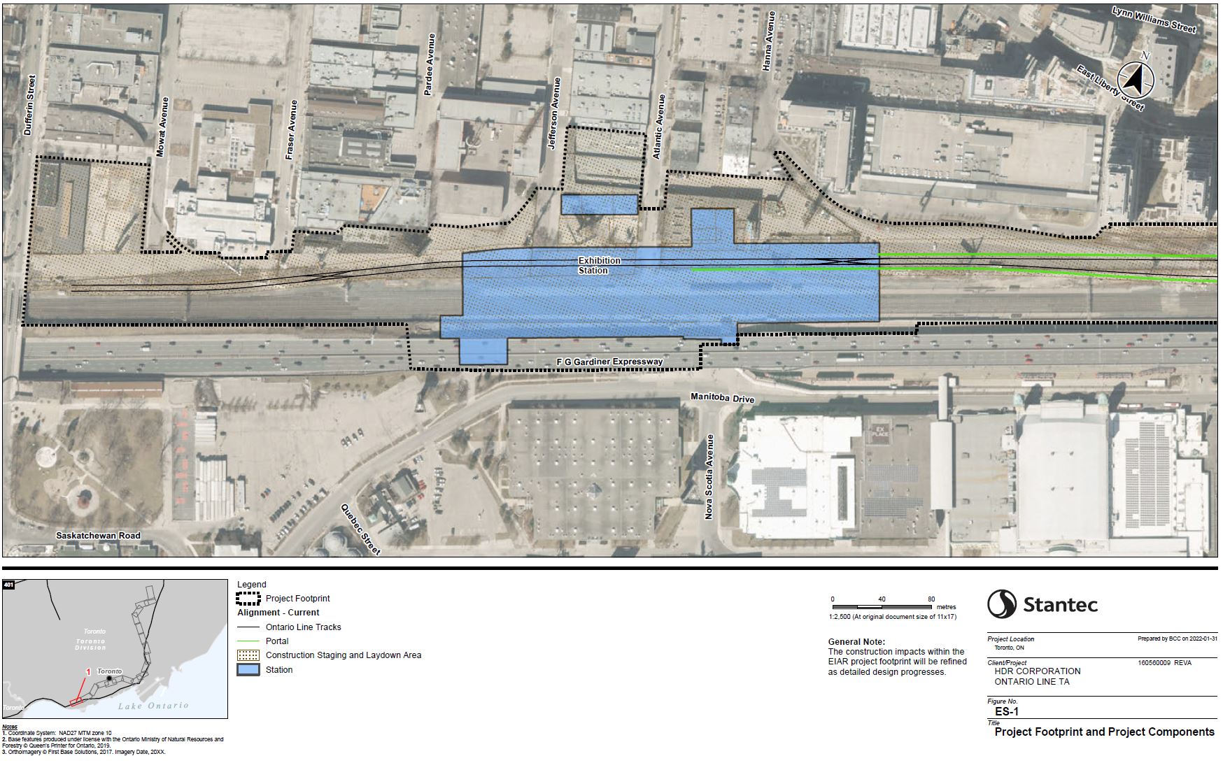
The portal lies west of Strachan Avenue. Emergency exits (pink dots) will be provided at the portal and in the Ordnance Park between the merging Lake Shore and Weston rail corridors. Just west of Strachan, there will be a substation (red star) which is conveniently beside a Toronto Hydro substation just to the south.
The portal will also be the extraction site for the tunnel boring machines making their way west from Corktown Station across downtown.
The OL does not interfere with the Fort York lands which are on the south side of the rail corridor.

King/Bathurst
The Ontario Line tunnel runs northeasterly from the Exhibition passing under the intersection at King and Bathurst about 28m below grade.

Spadina to University
At Queen and Spadina, the tunnel is 30m underground. As at King/Bathurst it will be accessed through two entrances. The buildings on the southwest corner will be demolished, but the facade of the office building on the northeast corner will be preserved.
Osgoode Station is a much larger construction site and there will be a large staging area including the east lanes of University Avenue and the lawn west of Osgoode Hall. The western chunk of the treed park on the north side of Queen will disappear. The fence around the hall will be dismantled and preserved for later re-installation.
The South African War Memorial in the middle of University Avenue north of Queen will be disassembled and stored during the construction.
The station at Osgoode will be 34m underground and will include a link to the existing University Line station above. Construction will involve partial closure of portions of that station and occasional weekend shutdowns of subway service similar to what has been seen with the Crosstown connection at Eglinton.
No plan of the link between the stations has been published yet.
On the map below, the areas in yellow are affected by the reinstallation of streetcar track for the 501 Queen streetcar diversion. (For those who might wonder, the TTC has been silent on the future of the currently-suspended 502 Downtowner service whose western terminus was McCaul Loop west of University Avenue. My suspicion is that the consolidated 503 Kingston Road service on King Street will remain for the foreseeable future.)

Bay to Moss Park
The station at Queen and Yonge will lie deep under the existing Yonge Subway 35m below grade with a multilevel connection between them (see the Tour article for details). There will also be significant staging areas for material and equipment on either side of the cut-and-cover station construction:
The laydown and staging areas are proposed along Queen Street West between Bay Street and Victoria Street. Along the eastern side of Victoria Street and on James Street from Queen Street East to Albert Street.
Draft EA, Table 3.4, p. 50
This description does not align with the project footprint where the laydown area is clearly on the west side of Victoria Street. It is unclear when the streetcar track on Victoria between Richmond and Dundas will be (a) rebuilt and (b) reactivated.
The EA states that:
The station entrance will be located on the northeast corner of Queen Street East and Yonge Street and will be incorporated into existing buildings.
Draft EA, p. 52
However, the drawing below shows entrances west of Yonge on the north and south sides of Queen (the south side will be through the existing Hudson’s Bay building). There is already an entrance to Queen Station on the northeast corner.
There will be a crossover between the east end of the station box at Victoria and Bond Street. Metrolinx has not detailed how this will be built, but the block is occupied on the north by St. Michael’s Hospital and this is an area where the connection between eastbound and westbound tracks will have to be mined.
East of Church, the tunnel swings north and will pass under Moss Park. The station at that site is 35m undergound, and it will be built cut-and-cover. There will be some street occupancy on Queen east of Sherbourne for staging.
This station has only one exit building, and Metrolinx claims that their design meets fire code. How this will be achieved is not yet known because they have provided no plans showing how two separate exits will be provided from platform level to the surface.

Corktown
East of Moss Park Station at Sherbourne, the line turns south along the east side of Berkeley Street to Corktown Station at King. The station box runs from the south side of King to just south of Front Street, and it will be 25m underground. The area between Front and The Esplanade/Mill Street will be the site of the tunnel boring launch and materials extraction during construction.
The main station entrance is at King and Berkeley, but there will be a second entrance at Front Street. It is unclear whether this will be a normal secondary entrance or only for emergency use. The map below shows it as a “Station” (blue), but text in the EA [p 52] calls it an “EEB” (Emergency Exit Building).
South and east of the station, the line turns under Distillery Lane along the north side of the rail corridor. According to the EA, this section of the line will be mined “from Corktown Station to the face of the Don Yard portal” [EA p 51]. The tunnel rises to the portal west of the river, but Metrolinx has not yet published a vertical profile showing exactly how this occurs and the tunnel’s relationship to other buildings.

West Don Lands
The drawing below shows the transition from the tunnel to the surface east of Cherry Street. The ramp and portal will be built within existing GO Transit property on the north side of the rail corridor. This will require the relocation of the leads to the Richmond Hill GO corridor in the Don Valley to provide space where the Ontario Line will emerge (green bars below) beside the Lake Shore East corridor before crossing the Don River on a new bridge.
Richmond Hill GO Corridor Realignment – The Richmond Hill GO Corridor realignment work will facilitate Ontario Line construction north of the Don Yard. During the diversion stage, a section of track will be shifted toward the Kingston subdivision direction to maintain the rail traffic, and both realignment and new track construction will be needed. At the final stage, track will be reconstructed on a different alignment, and a retaining wall will be built.
Draft EA, p 59
Two emergency exits (pink dots) are shown. One is west of Cherry Street with its access point south of the rail corridor, and one is at the south end of Tannery Road. The latter exit is not mentioned in the text of the EA.

East Harbour
This view continues east from the portal through East Harbour station where there will be a new transit hub for GO, the Ontario Line and the future southern extension of streetcar service on Broadview Avenue.
The EA claims [p 53] that the station will allow cross-platform transfer between the Ontario Line and GO Transit services even though this refers to a now-abandoned version of the station.
There will be a new OL bridge and a replacement GO Transit bridge at Eastern Avenue with the entire corridor raised to provide a 5m clearance to the street below.

Riverside
In Riverside, we come to a very contentious part of the project where local opposition to use of the rail corridor has been substantial, albeit without shifting Metrolinx’ position. From the project footprint shown below, much of the existing treed area along the corridor will be affected. As at other locations, no detailed tree inventory or replacement plan has been provided by Metrolinx yet.
The EA refers to a staging a laydown area at Riverside/Leslieville Station:
The laydown and staging areas are proposed adjacent to Riverside/Leslieville Station. These areas will be used for storage of construction equipment and materials required at the construction sites. Areas will be fenced for security and controlled access.
Draft EA, p. 51
However the drawing shows no such area, and the community was assured during consultations that construction would be staged south along the rail corridor from property along Dickens Street (north of Dundas at the right end of this map). This should be clarified by Metrolinx.
The existing rail bridges at Queen, Dundas and Logan will be replaced, and the new OL infrastructure will be built to provide a 5m clearance under the corridor. Queen and De Grassi is a frequent location for problems with TTC overhead due either to streetcar dewirements or to high vehicles driving in the streetcar lanes.

Gerrard
At Gerrard, the Ontario Line splits from the rail corridor and swings north under Pape Avenue. The station itself will straddle Carlaw Avenue and Gerrard Street. The portal structure and launch area for the tunnel boring machines will be north of the rail corridor between Carlaw and Pape south of Langley Avenue (green on the map below).
At the southwest end of the station, the existing park on Gerrard Street as well as an adjacent property on First Avenue will be used for construction access and staging. However, the main areas for staging will be north of Dickens Street and east of Carlaw on the south and north sides of the rail corridor respectively.
A short section of the sewer under Pape connecting to Langley will be shifted west from Riverdale Avenue south to Langley to avoid conflict with the Ontario Line tunnel as it descends from the surface (blue line on the map below). This will pass under the east side of the schoolyard at Pape Avenue Public School, and the new sewer will be tunnelled.
There will be an emergency exit building on the northeast corner of Pape and Bain Avenue.
The existing rail bridges at this location will remain as they already provide sufficient clearance for the streets below.

Pape From Danforth to Cosburn
Several blocks south of Danforth, the tunnel will swing east and pass under the Danforth Subway. A large portion of the block west of Eaton Avenue and north to the existing bus loop will be taken for the construction site. The station will be built cut-and-cover, and the OL will be 30m underground. Some modifications will occur to the existing station, but these have not yet been detailed by Metrolinx.
An existing parking lot on the west side of Pape will also be used as a laydown/staging area.
As at other junctions, Metrolinx has not yet published drawings showing how the interchange will work

Heading north from the station, the tunnels first swing west under Pape Avenue and include a crossover south of Sammon Avenue. They then shift further west on the approach to Cosburn Station.

Cosburn Station will be built cut-and-cover on the west side of Pape between Gowan and Gamble Avenues about 25m underground. Some land west of the station, including part of Cosburn Avenue itself, will be used for laydown/staging.

Don Valley Crossing
At the north end of the Pape tunnel, the line emerges through a portal at Minton Place (which continues the line of Pape north after it swings over to the existing Leaside Bridge which is just out of frame at the bottom of this map). Four houses will be expropriated for the portal structure and there will be considerable work within the valley for construction of a new rapid transit bridge. The piers of that bridge are shown in green below.
There is an emergency exit at the portal (pink dot).
A sanitary sewer (blue line) will be shifted to be clear of a bridge pier just north (to the right in this map) of the DVP. As the project footprint shows, Ontario Line work will affect a considerable portion of the valley. (Details of this are probably like so much of the plan, something to be revealed/decided during detailed design long after the EA is approved.)
Temporary construction access roads and staging areas will be constructed to facilitate the construction of piers and other elements of the substructure of the Don Valley Crossing Bridge across the Don River valley, as well as a temporary bridge across the Don River, a crane assembly area and other staging areas to facilitate the construction of the superstructure of the Don Valley Crossing Bridge. The temporary bridge is required to facilitate construction activities while erecting the Don Valley Crossing Bridge.
Draft EA, p 55
The new OL bridge crosses the existing Hydro line (dotted black below) twice, and it is not clear of existing lines. Hydro will relocate its plant to the west of the proposed OL bridge.
The proposed Don Valley Crossing Bridge of the Ontario Line, crossing over the Lower Don Parklands, crosses a Hydro One transmission line for which the clearance requirements are not met. To mitigate this conflict with the existing overhead transmission line, Hydro One will remove existing structures and associated components of a portion of the transmission line south of Millwood Road and install new structures northwest of the proposed Don Valley Crossing Bridge of Ontario Line.
Draft EA, p 58

Thorncliffe Park
After crossing Millwood Road at the north end of the Leaside Bridge, the Ontario Line runs on an elevated structure along the north side of Overlea to Thorncliffe Park Station. Note how the pier spacing widens as the line travels east to accommodate the wider track spacing for a centre platform at the station.
Metrolinx has not published any diagrams showing how close the structure will be to existing buildings on the north side of Overlea, notably 20 Overlea (the site of a new Mosque and community centre) just west of the station.
There will be laydown areas at Thorncliffe Park Station, but their description does not make sense. It is not clear exactly where these would be.
The laydown and staging areas are proposed west of Overlea Boulevard on the north and south sides of Thorncliffe Park Drive.
Draft EA, p 55
There is provision for a bus loop here although the number of routes it would serve would probably be small given the presence of other nearby stations notably Science Centre. This would, however, increase the catchment area of the station and alleviate some access problems due to boundaries like the railway. This is a station that with good bus service could draw from north of the rail corridor, and could also support considerable redevelopment. Oddly enough, Metrolinx and Infrastructure Ontario focus on downtown stations and are silent on locations like Thorncliffe and neighbouring areas.
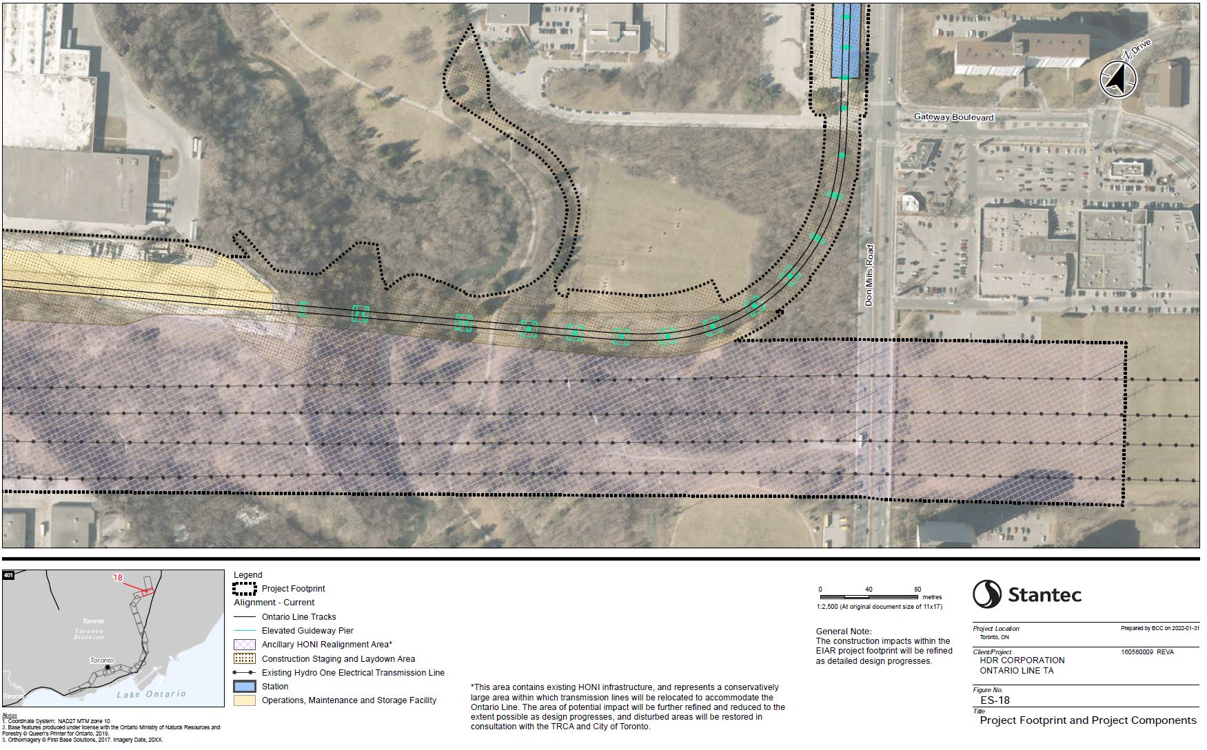
The large area in yellow in the two drawings below will house the Maintenance and Storage facility. Its odd shape is due to working around the major hydro corridor connecting to the switching station on Millwood Road.

The line will drop to grade south of Pat Moore Drive to go under the Hydro corridor and to connect with the MSF, also at grade. East of the MSF, the Ontario Line turns east and crosses Beth Nealson Drive which will be lowered to pass under the guideway which stays at grade until the West Don River crossing (right edge of the map below).
The Hydro corridor here must be adjusted to accommodate the Ontario Line. Note that this is the west end of the “Gatineau” corridor that links to nuclear power stations east of Toronto and it is a major entry point for electrical power for the city.
Walmsley Brook Crossing Bridge – The proposed Walmsley Brook Crossing Bridge of the Ontario Line, located in Thorncliffe Park on the southeast side of the existing Canadian Pacific Railway and west of Beth Nealson Drive, crosses existing and future transmission lines. The majority of the existing and future transmission lines do not meet the clearance requirements with the proposed Bridge and the OMSF structures near the crossing of the Ontario Line. To mitigate conflict, Hydro One will remove existing structures and associated components of a portion of the transmission line and install new structures east of the existing structure locations and east of the proposed Ontario Line. To ensure continued and reliable supply within the City of Toronto, Hydro One will also install permanent and/or temporary bypass transmission line structures north of the existing transmission lines.
West Don River Crossing Bridge – The proposed West Don River Crossing Bridge of the Ontario Line, east of Beth Nealson Drive, is in close proximity of the existing Hydro One transmission lines west of Don Mills Road and is located within the Hydro One transmission corridor intended for future transmission lines. To mitigate the conflict with future transmission lines, Hydro One will remove existing conflicting structures and install new structures east and west of Don Mills Road. To ensure continued and reliable supply within the City of Toronto, Hydro One will also install permanent and/or temporary bypass transmission line structures north of the existing transmission lines.
For those who are wondering, Walmsley Brook is a tributary of the Don River originating some distance northwest of this area. Most of it is underground, and it runs through, yes through, Leaside Station (Bayview) on the Crosstown Line in a large pipe.

Flemingdon Park to Science Centre
East of Beth Nealson (out of frame to the left), the line crosses the Don River (again) on a new bridge, and then turns north on the west side of Don Mills Road. The green dots show proposed locations of piers. This will be a side platform station.
As with the crossing further south, there will be work in the valley for construction of a new transit bridge.
Temporary construction access roads and staging areas will be constructed to facilitate the construction of piers and other elements of the substructure of the West Don River Crossing Bridge across the West Don River valley, as well as a temporary bridge across the West Don River and other staging areas to facilitate the construction of the superstructure of the West Don River Crossing Bridge. The temporary bridge is required to facilitate construction activities while erecting the West Don River Crossing Bridge.
Draft EA, p 56
Flemingdon Park Station lies between Gateway Boulevard and St. Dennis Drive just south of the Science Centre building. The overhead structure crosses Don Mills to a terminal station above the existing Science Centre Station bus loop. There is provision for a tail track and future extension.
The laydown/staging area for Flemingdon Park Station will be on the west side of Don Mills. At Science Centre Station, land around the existing bus loop will be used.
A large amount of development is already in the works for this intersection, but there has been no discussion of station access. The two known points are on the southwest and northeast corners. Has anyone has though of underground links for the other corners, if only to avoid a lot of surface level pedestrian traffic? That’s the sort of thing that should be built concurrently with this project, not as an afterthought.
Like Flemingdon Park Station, this will be a side platform station even though it is a terminal. This implies that trains will reverse north of the station via a crossover (not shown).

Errata
I wrote to Metrolinx on February 10 with a list of questions about various issues in the EA document. They replied on April 6. The questions and responses are below. This has been lightly edited for format, and Metrolinx’ responses are italicised.
Thank you for the detailed review of the Draft Environmental Impact Assessment Report (EIAR) and for providing the comments below. The necessary updates were made to the EIAR text, and the Final EIAR report will be made available on April 8, 2022. We are writing to share our responses below:
Page 50: “The laydown and staging areas are proposed along Queen Street West between Bay Street and Victoria Street. Along the eastern side of Victoria Street and on James Street from Queen Street East to Albert Street.” The map for this segment clearly shows that the project footprint is on the west side of Victoria not the east. Which is correct?
The Project Footprint and Project Components figure is correct, the laydown and staging areas are located on the western side of Victoria St. The text in the Draft EIAR will be revised and the updated version of the report will be made available April 2022.
Page 52: “The station entrance will be located on the northeast corner of Queen Street East and Yonge Street and will be incorporated into existing buildings.” There is already a station entrance on the NE corner of Queen and Yonge. The map shows new entrances west of Yonge on both sides of Queen. Is the text on page 52 wrong?
The text in the Draft EIAR will be revised and the updated version of the report will be made available April 2022.
Also east of Queen Station there will be a crossover in the block in front of St. Michael’s Hospital, although this area is shown as tunnelled. Will the links between the tunnels for the crossover be mined to avoid the need for C&C construction at the hospital?
As stated in Table 3-4. OLS Section Key Component, the Queen Station Crossover will be excavated using Sequential Excavation Method.
Page 52: “The station entrance will be located on the east side of Berkeley Street at King Street East. The station platforms will be located approximately 25 metres underground. An EEB connected to the station will be located on the east side of Berkeley Street at Front Street.”
At Corktown station, the text describes the south entrance as an emergency exit, but the map shows it in blue indicating a regular (albeit secondary) entrance. Which is correct?
The Project Footprint and Project Components figure is correct, however this is a secondary exit only. The text in the Draft EIAR will be revised and the updated version of the report will be made available April 2022.
In the West Don Lands, the text speaks only of an emergency exit west of Cherry, but the map shows an additional EEB at the foot of Tannery Road. Is that EEB really in the plan given how close it would be to the one at Cherry?
The Project Footprint and Project Components figure is correct, a second emergency exit is proposed at the foot of Tannery Rd. The EEB at the foot of Tannery Road provides for emergency access to Ontario Line within the Don Yard for Toronto Fire Service, provides public emergency egress from Ontario Line trains and allows for the Project to be in compliance with the requirements of the National Fire Protection Association (NFPA 130), which requires that emergency exits be no more than 762m apart. The distance between the Cherry St EEB and East Harbour Station exceeded 762m. The text in the Draft EIAR will be updated to make this clear.
Page 53: The text claims that cross-platform transfers will be possible between GO and the Ontario Line at East Harbour. However, this was dropped with the redesign of the station to shift the Ontario Line to the north side of the corridor. Is this text a holdover from the earlier design in error?
Correct, this is an error in text. Transfer between Ontario Lines and GO Transit will be supported through a concourse. The text in the Draft EIAR will be revised.
Page 51: “The laydown and staging areas are proposed adjacent to Riverside/Leslieville Station.” However during community meetings, Metrolinx stated that all work would be done from within the corridor notably from the large staging area north of Dundas. The map does not show (via shading) any laydown/staging area at Riverside. Is this an error in the text?
Correct, this is an error in text. The Project Footprint and Project Components figure is correct. The text in the Draft EIAR will be revised and the updated version of the report will be made available April 2022.
Page 55: The text says: “The laydown and staging areas are proposed west of Overlea Boulevard on the north and south sides of Thorncliffe Park Drive.”. This does not make sense because Overlea runs east-west while Thorncliffe Park Drive is north-south. It also does not match with the footprint shown on the map. Is the text wrong?
The Project Footprint and Project Components figure is correct, staging/laydown areas are proposed on the north side of Overlea on both the east and west sides of Thorncliffe Park Drive. The text in the Draft EIAR will be revised and the final version of the report will be made available April 2022.
On the map of Science Centre Station, there is no end of line crossover shown. Given that this is a side platform station, I assume that the crossover will be north of the station and the terminal will run with separate northbound and southbound stations. I this correct?
The platforms at Science Centre will be located on the east and west sides of the elevated guideway. A crossover is planned for north of the Science Centre Station, the Draft EIAR will be revised and the updated version will be made available in April 2022.
Thank you again for your engagement in the environmental assessment process for the Ontario Line.
Sincerely,
Caitlin
Caitlin Docherty (she/her)
Community Relations & Issues Advisor – Ontario Line

It’s so nice as a resident of Cosburn Avenue and Pape we’re being completely ignored by Metrolinx and made as an afterthought. It’s clear a ton of buildings are going to get torn down obliterating the neighbourhood for the station. Can’t wait for the next election. This needs a major redesign. Disgusting.
LikeLike
Excellent review as always. It’s clear this Impact Assessment is a joke – a very unfunny one at the expense of all taxpayers and host communities on the route – Where are the ‘impacts’ ? How they can they be assessed if we don’t even have the engineering drawings, roll plots, and results of current (not out of date) field studies and current Arborist Reports? The Ford government continues to bulldoze anything and anyone in the path Ontario Line at any cost. Oh yes, Ontarians–along with billions of our federal tax dollars will be paying for this turkey – if it ever opens – for generations to come.
LikeLike
For the Don Valley crossing near Leaside, they should include pedestrian and cycling paths (strong and wide enough for emergency vehicles) to use. The current Millwood/Leaside bridge has terrible cycling lanes and sidewalks, since space was taken over for widening it for more traffic lanes for the almighty automobile instead of streetcars, which was the original purpose for its width.
Steve: At both ends of the bridge, the elevation will be considerably different from the surrounding streets. This is not just a question of widening the proposed bridge. This would get even more complicated if in effect we were building a new road bridge for emergency vehicles.
LikeLike
Metrolinx and the civil employees working there lying and being generally dishonest in their work? Must be another day ending in -day.
LikeLike
It really, really bothers me that Flemingdon Park is the closest stop to the Science Centre. While Science Centre Station really serves a different area. They’re going to change that, right?
Steve: No. And where would you like another station? It is only 700m from Gateway Blvd to Eglinton.
LikeLike
Where are the drawings of the retaining walls (concrete) and noise walls (acrylic) that will reach a height of up to 12m (40 feet) in some locations in the Joint Corridor between Eastern Ave. and Gerrard St. E.? These walls will be bordering on both private lands and public spaces and will have a definite negative “environmental impact”.
Steve: As with so many parts of this “Environmental Assessment”, these details are not included but will be finalized as part of the detailed design process once the construction contract is awarded. As you may know, there is “consultation” underway about the nature of these walls, but it amounts to choosing the colour of paint. There is no discussion at all of noise wall designs in the Noise and Vibration appendix, only the recognition that something would be required at various places along the line.
Regarding your email to me complaining that I was not posting your comment:
All comments here go into a moderation queue where they sit until I have reviewed them. I get some abusive and obscene comments, and do not want readers to be subjected to that sort of drivel. Also, I reply to many comments as well as tidying up spelling, grammar and layout, although that was not required in your case.
People have been getting this blog and all of the work I put into it free for years. If you want to complain about turnaround on posting comments, go somewhere else.
LikeLiked by 2 people
There really should be a crossover west of the University line in any new line through downtown in addition to the crossover at Yonge. It would be for operationally redundancy to avoid situations like we get on line 2 where trains have to turn back at Chester whenever there are station shutdowns between St. George and Broadview.
Steve: I suspect that Metrolinx is trying to avoid the expense of mining between the running tunnels to put in more crossovers in underground sections.
LikeLike
Steve, as per always, thanks for a very interesting article. I think I’ve mentioned before I live a couple of blocks south of the future site of Corktown station, and have taken a lot of photos of construction in that area. The very first new building whose construction fascinated me was the building on the NW corner of Parliament and King – so almost across King Street from Corktown station.
What fascinated me during the very long excavation of the basement of this building was how shallow bedrock was. This was about a dozen years ago. As I recall the basement of the building was three or four storeys deep, and bedrock was found about five metres down.
There is a map, which I think you reproduced a few years ago, which shows the depth of the Yonge subway line, and the depth at which bedrock was found, along its length. I believe it showed both bedrock, and the surface of the ground rising, until Eglinton. As I recall bedrock levelled off there, while the surface of the ground kept rising.
It is my impression, from other construction sites, that bedrock is quite shallow basically everywhere under King, and still shallow, but not as shallow, basically everywhere under Queen.
You said the stations at Bathurst, Spadina, University, Yonge, Sherbourne, and Berkely were all around 25-30 metres deep. And I am guessing that this is so the entire tunnel is bored through bedrock, with a layer of bedrock above the tunnel.
Steve: Yes, the tunnel is completely in bedrock. The depths are those cited by Metrolinx in the Draft EA.
The aerial photos show the line emerging from underground just south of the flood prevention berm, just east of the Don River. I have pictures of that area. Much of it is scrubby wood. My, that seems like a long section to mine. It must be well over half a kilometer.
Steve: No, the line emerges west of the Don River just east of Cherry Street on the north side of the rail corridor. There will be a new bridge across the Don north of the existing rail bridges, and East Harbour Station will be at the elevation of the rail corridor. From there to the north, the corridor will be regraded to improve bridge clearances which are tightest at Eastern Ave (under 4m) to Logan to a new 5m standard.
The aerial photo of Gerrard station… I’ve visited that site pretty often, too. The photo shows a bridge, at Pape, crossing over the rail lines. It is only a footbridge. It is quite tall. You probably know this, but, for everyone else, the Gerrard Square Mall is not visible in this photo. The parking lot the line crosses, as it goes underground, is for a lesser mall. It had a large supermarket, in it.
If I recall correctly, planners were going to tear down everything connected with both the Gerrard Square Mall, and this less significant mall, and the whole parcel was something like 50 acres. I find it interesting that the station is in the extreme NE corner of the parcel.
Steve: Any planned demolition on the Gerrard Square Mall east of the railway would be part of a redevelopment of that property, a rather obvious target for intensification with a new station next door. Gerrard Station is not in the NE corner of the parcel. It spans Gerrard Street. What is in the NE corner is the portal to the tunnel north under Pape.
BTW, “planners” do not tear down buildings, developers do.
Thanks again.
LikeLike
In your (usual) great review of the EA you note that Victoria Street will be used for laydown work, one one side or the other. In the traffic changes that Council approved last week, they only talk about streets west of Victoria being closed plus the west side of Victoria at Queen.
Steve: There are several errata in the EA including the claim that the east side of Victoria would be a laydown area. I have written to Metrolinx with a list and await their reply. As a general observation, there are places where I think the document was written some time ago and has not been carefully edited. This raises the question of whether plans have changed, or if Metrolinx is just sloppy, or worse that they are trying to slip changes in that people might not notice.
LikeLike
You are providing a very valuable public service, Steve, by reading the documents and telling us what they say. I am fascinated by such things, and naturally jumped to the maps as soon as the documents came out. But I haven’t had time to read them.
In terms of the substance, I am worried about long transfers between existing platforms at Osgoode and Queen to new platforms. With Queen, I understand the engineering difficulty of having one platform under the other, but it seems that Metrolinx has adopted the TTC approach of letting engineering, rather than customer service, dictate designs.
Also, Osgoode is not connected to the PATH. Will this be corrected? There is no point in having a heavily used interchange station if the PATH cannot absorb some of the volume.
Finally, I agree with your view expressed in previous posts that building an entrance on the Osgoode Hall grounds and disrupting the fence is unconscionable. In the earliest photographs of Toronto from 1857, Osgoode Hall features prominently. It is one of the few buildings still standing from those photos. We need to treat our most historic buildings with more respect. Would the British build a subway entrance in front of Buckingham Palace? The same, by the way, goes for the South African War Memorial. Surely if they are going to block part of University they could use a greater stretch of the roadway instead of taking down the memorial.
Steve: I have been rummaging in the 5,400 pages of the correspondence summary which vanished from the project website (Appendix B) but which is still available from the Internet Archive. (Warning: 110MB download) Among other things this contains comments from the downtown BIA about expanding the PATH network, and from the Law Society of Ontario who are clearly not pleased with what is proposed. Metrolinx trots out the usual excuses about its project and about how the details will be worked out in the design stage which, of course, will be long after the basic parameters of the project have been decided.
As for the SA War Memorial, the intent is to disassemble it and later restore it after construction. This was also done for construction of the University Subway. It would be a perfect opportunity to restore it to a different location as part of the “University Park” scheme that would combine the centre median space with the east sidewalk.
LikeLike
I’m holding out hope that the Osgoode plan is a negotiating tactic by Metrolinx so that when they later announce a change to only take up the northbound University Ave lanes and not the Osgoode Hall yard they’ll look responsive to community concerns and caring for trees (*cough* Old Elm) and whatnot. But it’s Metrolinx, so I’m prepared to be disappointed.
LikeLike
So the traffic study groups together all of the downtown stations on a couple pages, despite them having the most pedestrians, cyclists and cars on the narrowest streets, with 5.1.2 directing readers to never released studies for info about their permanent impacts. And then 5.3.2.1 says that the Pape interchange design will permanently require riders to exit the station to make some transfers.
Am I reading that right? Why aren’t the traffic studies of those stations part of this environmental assessment? How have they not released the station designs yet?
Steve: I have not yet read the traffic study portion of the EA. It has its own appendix. No, the station designs have not been released.
LikeLike
It’s ironic that 4 houses on Minton Place are getting a lot of discussion but not a word about the 8 houses at Pape and Langley and by my count around 30 houses at Pape and Danforth. Is this because the level of detail of exact footprint is only being released now?
On a frustrating note, since the Ontario Line was announced in 2019, the property on the NW corner of Pape and Cosburn was demolished, and a new one has just been completed. Now a brand new building needlessly need to be destroyed – what a waste. Slightly similarly is the Thorncliffe Costco which was constructed after the Relief Line planning was underway. In terms of transit planning we seem to be awful at strategically acquiring property to minimize cost, impact, and waste.
As always, thanks for the reporting and summary of the EA.
Steve: Yes, it was intriguing that certain stations simply were not discussed in the various public presentations notably Pape/Danforth, Cosburn and Osgoode. Seeing some of the details in the EA, notably the work Ontario Hydro has to do to relocate some transmission lines, I can see that Metrolinx really didn’t understand where they were planning to build and just drew lines on a map. Of course one of the senior people on the project was responsible for SmartTrack, so what can I say?
The extent of demolition at some locations only became clear when we saw the footprints in the EA. Metrolinx had never discussed these before. There are words for that kind of behaviour, and they are not very complimentary.
LikeLike
Hi Steve
Hope you get to appendix Noise and Vibration. Within it, is appendix Q at page 370, Noise and Vibration Operations Report Ontario Line – Lakeshore East Joint Corridor. Its summary reads:
I’m concerned about the noise levels at the big grade near where Robert Wrightman used to teach. I know the ambient noise level is 90 db from Smarttrack EA’s. Why are these EA’s so hard to read? Hope you can translate.
Steve: I will come to this appendix in time. There has been an ongoing battle between the Riverside community and Metrolinx about how they present Noise & Vibration information. One big problem is that the industry standard way of expressing noise is the “Leq” metric which averages noise over a period. In this case there are the daytime (defined as 7am to 11pm) and nighttime (11pm to 7am) intervals. What is not shown is the peak noise level, especially for evening and overnight operations.
The whole Leq methodology is more appropriate to a setting such as a highway which has a constant hum of activity as opposed to a railroad which can be dead silent and then extremely noisy when a train passes.
The noise barriers will cancel out a lot of noise where they actually do block the path from the corridor to nearby buildings, but there are locations where there is line of sight from higher buildings down onto the corridor, and the barriers will do nothing for them. At the same time, the barriers, plus the regrading upward of the corridor, will increase the physical presence considerably.
Metrolinx plans some vibration attenuation measures both on the GO and OL tracks, but the study suggests that they will be parsimonious in where these are installed. For example, they have often spoken about resilient floating-slab construction, but do not plan to use it through the entire line, only where there are projected problems. This is not a technology that can be retrofitted if they got it wrong.
All of that said, there have been some misrepresentations by the community about train noise where the tenfold increase in trips, the vast majority of which are due to OL trains, are spoken of as if they will all be at the level of existing GO trains. This has been very annoying to me because I presented the original charts comparing service levels from Metrolinx plans here on this blog. There is also an offset because GO will convert to electric operation for the Stouffville corridor and about half of the Lake Shore East corridor, albeit at a more frequent level of service than today.
There has been a lot of fog on this issue, and Metrolinx has not helped one bit by taking a contentious approach to providing background information.
LikeLike
Is there a list of the depths of existing subway stations so we can get a feel for how deep the OL stations will be? Like as deep as Dundas West, or Bathurst, or? My search for a list of subway station depths did not come up with anything useful.
Basically, do we have some ~30m deep subway stations already, which we can use for comparison purposes?
Steve: There is not a lot of info on that, certainly not collected in one place. I ran across a web reference to York Mills being 188 feet down, but am not sure of this because the south end escalator, according to Nathan Ng’s Station Fixation page, the escalator is 76 steps long. Escalator treads are not spaced 2.5 feet apart (188/76 = 2.47). 188 feet would be over 50m down.
Dundas West is comparatively deep because the tunnel has to get under the railway corridor, but even then it’s not a huge distance below the surface. A drawing I have of it shows the platform elevation as 101.3m and the surface at 112.52m, a difference of 11.49m (about 38 feet). Bathurst is shallower and is only two levels down from the surface (there is an intermediate level at Dundas West not open to the public that is accessed from the landing midway down the stairs).
30m is a long way down. If you consider the average height of a high-rise floor to be at most 9 ft (8 ft headroom plus slab), or 2.74m, then a 30m deep station is the equivalent of a 10-11 storey building.
LikeLike
This comment is really strange. There is no point in having a heavily used interchange station if the PATH cannot absorb some of the volume? I guess that we should shut down heavily used interchange stations such as Bloor-Yonge, St George, Spadina, etc because they are not connected to the PATH and there is no use in having them.
Steve: For the benefit of readers unfamiliar with the station, there is no PATH connection today at Osgoode.
LikeLike
Steve: For the benefit of readers unfamiliar with the station, there is no PATH connection today at Osgoode.
Given that Osgoode will be quite deep, is there an opportunity to connect it via tunnel either to the PATH at the Hilton or Sheraton?
Steve: No. If there were a connection, it would likely go via the existing link into the basement of the Opera House and then across York to the Sheraton. Nothing is going to be built down in the bedrock way below the elevation of the PATH tunnels around downtown. For those who don’t know the building, there is an exit from Osgoode Station into the 1-below level of the Opera House for access to an elevator which takes you up to the street in their foyer, or down to the parking garage.
LikeLike
Thanks Steve, and commenters, and maybe even some thanks to some of the staff/workers who’ve laboured away on this effort, which is akin to having the Edsel technically sufficient. All of the Ford transit priority projects are costly clunkers that deserve a rethink/reject if we want to use the billions better. Though at times I sure think we’re the Torontic, and it’s Fool Speed Ahead – including with contracts to lock us in to a sinking-of-transit project or three, although I do want billions to be invested in transit, but in multiple projects, and in a much cleaner/better process that looks at all the options, and for instance, provides relief function not a megaproject, where it’s any type of subway as long as it’s here approach. And I don’t think we know that it’s even as robust as a subway yet, and we’re mixing/matching a Relief of Yonge and Relief of GO, we’re not looking for anything too much beyond a milk run vs. sub-regional/express trips. Too bad the top-down approach isn’t actually from the top of a Relief function as per the last Metro OP which wanted GO to do an EA to link Richmond Hill GO line to Eglinton/Don Mills/Relief, but that was only 25 years ago.
Would straight-line transit in the old core actually mean we could tunnel under streets and not buildings,and thus not be burdened with incredibly deep tunnels, with their time and energy penalties for users/transit/taxpayers to bear?
How much would it cost to do an elevated structure instead? And if elevated, could we convert the Gardiner, or parts of it, to a robust transit, as if one did a people-moved count, hmm….
But it’s not about good value for tax dollars, nor building good transit for the core of Toronto, but rather feels like enrichment of some developers and construction interests and some of the politicians, and hoping that the core won’t notice that any further extension of the Yonge Line further north will make a brittle system even worse, and won’t really fix crowdings.
I sure hope the opposition parties are a bit smarter, and we should be reminding everyone of the cancelled Eglinton subway line after Mr. Harris took over, which at least was in the 1957 plan, along with twice the length of the Relief/Ontario Line, so we can take another few years to reform processes, and focus on a triage Relief function response, along with a more robust subway plan more akin to the 1957 plan, though likely it should go further east, and then N, and then NE.
It’s also foolish to ignore the flood of cars coming in through the pinch point at the base of High Park, which is where we should be targetting to reach with robust transit. There’s a natural possible car-free or reduced zone bounded by High Park, the tracks, the Don River and the Lake, but we have to have improved transit, obvious from 1957 and earlier, yes.
LikeLike
Is there any issues/concerns here that Metrolinx is being too shortsighted with their planned stations downtown? I do notice that Osgoode, Queen and Pape will make use of centre platforms for connection stations, and as such, have to put a concourse between the two lines. I know in this case it is likely cheaper (and thus more appealing for Queen’s Park) to build, but if they are building this line to provide ‘relief’ for the downtown transit system, should they not ‘future-proof’ these stations by making them side platforms? If not, it will create similar issues that will be created at Eglinton and Eglinton West with the Eglinton Crosstown, and lead to us to spend more money in the future to expand the stations.
Steve: There is nothing inherently wrong with centre platforms provided that they are wide enough and have sufficient vertical circulation. With deep stations, it is a lot easier to share elevator and escalator capacity (and redundancy) between the two directions rather than having to duplicate this for each direction. That said, I await Metrolinx’ publication of station designs.
LikeLike
I am sharing this, in the hope someone can straighten me out.
I am interested in the noise levels of the Ontario Line through Riverside. A few years ago, Mayor Tory and Steve attended a SmartTrack public session at Queen Alexandra Middle School. A homemaker explained why Metrolinx refused to install sound barriers in her neighborhood, next to the tracks. Metrolinx only has to install sound barriers if the trains increase noise levels by 5 decibels. Her neighborhood did not qualify because the ambient noise level was 70 decibels.
I felt that a noise level of 70 decibels was too loud for a residential environment. There is a guideline that suggests 55 db day and 50 db night levels for residential zones. Metrolinx is only concerned about its legal requirement to provide sound mitigation whenever new operations exceed 5 db over baseline levels. The level of additional noise the new trains would add was less than 5 db from the 70 db baseline. There was no consideration that 70 db was unacceptable.
So I was interested in what the Ontario Line Environmental Assessment (OL EA) report
would say about the Riverside noise levels in the Appendix Noise and Vibration, in Appendix Q Noise and Vibration Operations Report Ontario Line – Lakeshore East Joint Corridor.
Click to access appendix_a6_-_noise_and_vibration_report.pdf
Metrolinx staff have not written any commentary but merely include the technical report (Appendix Q) to address the legal requirement of the Ontario Line to identify where its operation would exceed 5 db to the baseline noise level. There is no concern over the level of noise in the neigbourhood.
I don’t understand the technical stuff but there is one thing I’m pretty sure of.
The OL EA refers to the report “GO Rail Network Electrification Project” which divides the OL route between Appendix G1: USRC Impact Assessment Report
Click to access appendix_g1_-_go_rail_network_electrification_usrc_n-v_report_19may21.pdf
and Appendix G6: Lakeshore East Impact Assessment Report.
Click to access appendix_g6_-_go_rail_network_electrification_lse_n-v_report_19may21.pdf
The OL EA specifically references the Electrification report for “Ground elevation data as previously modelled for the GO Rail Network Electrification Final Environmental Project Report Addendum in combination with provided design elevation data for the Ontario Line and GO tracks”. This means the OL EA team did not undertake ground elevation studies but claims it was done in the “GO Rail Network Electrification Project”. The OL team is caught out because the “GO Rail Network Electrification Project” specifically did not undertake studies from Cherry Street to Carlaw because it would be covered in the OL EA. The OL EA does not account for ground elevation. Check the “However …”, in the following two definitions of Study Area. Riverside is omitted.
From Appendix G1: USRC Impact Assessment Report
From Appendix G6: Lakeshore East Impact Assessment Report
And 2.1 Study Area
Steve: I will jump in here to explain. The GO reports deliberately omit the section from the Don River to Gerrard because this is the joint corridor with the OL, and is the subject of a separate report, Appendix Q to the OL EA. Both GO and OL factors are supposed to be considered as part of that study.
I consider topology important because the throttle position of the engines will generate greater noise attempting to go uphill versus downhill. In Riverside, the eastbound trains are going uphill and are noisier than the trains going downhill. I was expecting to see this noted in the technical measurements in Appendix Q. Neither the OL EA nor the Electrification Project account for topology.
Steve: This has been an ongoing issue for the neighbourhood. A related issue is that after electrification, the sound of an eastbound train will be much lower. However there will still be about the same number of diesels in the future as there are today because as things stand now the Bowmanville extension will not be electrified (it’s in CP territory). This shows up in the projected counts of trains in the corridor by equipment type.
While trying to read through the reports, I begin to understand Steve’s reference to LEQ. LEQ is used to determine the base line noise level before new equipment is added. They have no idea how noisy the new equipment will be. Maybe they will get some coal fired steam locomotives. If the anticipated additional noise of the new equipment exceeds 5 db over the LEQ at some point on the line, then Metrolinx will be required to construct sound mitigation there. So what the report is looking for are the “quiet” zones where a new train will be adding more than 5 db. They love the areas of high LEQ because those areas will not require noise mitigation.
All this does not address citizens’ true concern of how noisy the trains will be. Sound engineers acknowledge that LMAX, the actual sound level of a passing train is very loud, easily 85 db. My point is that the eastbound trains are going uphill so the LMAX of eastbound trans are louder than westbound trains. The frequency of these trains and how loud they are, will raise the LEQ average. Even in the Appendix Q study there are LEQ’s of 60 and 70. Residents should not be victims of these levels and it is a loophole in the way the rules are written that they do not protect citizens.
It would be my hope that everyone write a response to the OL EA stating that the LEQ of the Ontario Line should be less than 50 dbs through all residential areas.
Can anyone clarify this matter?
Steve: The basic problem is that the whole sham of noise measurements is based on equalized values, not on peaks. You could have a line that is utterly silent except for an exceptionally noisy train that came through once a day at 3am. On an “equalized” basis it would not be bad, even if it woke everyone up. Even during the daytime, a corridor might be quiet most of the time, but every time a train passes, conversations stop.
All of that said, it is very important to distinguish between types and numbers of trains. Some community comments reported in the media treat them all the same, and that is as bad at the other extreme as Metrolinx finagling with “averages”.
LikeLike
There is no need for a PATH connection. There is no reason why every Ontario Line station needs to be connected to the PATH. If you want PATH, then you can take the Queen station instead of Osgoode which will be adjacent stations on the Ontario Line. Let us not waste taxpayer dollars on needless things.
LikeLike
The Leq vs Lmax being equivalent is like saying getting hit by 200 pieces of hail carries the same energy as being hit by 9mm bullet. Total energy might be the same but the effect is a lot different.
LikeLike
From EngageIO and Urban Toronto:
Ontario Line:
Lakeshore West GO Train:
Streetcar Extension:
Bus Transit Services:
Steve: Yes, I know all this and am working on an article about the Infrastructure Ontario proposals not just at Exhibition but also King/Bathurst, Queen/Spadina and Corktown. The problem with them is that they only cover the sites where IO has a “Transit Oriented Community” plan in the works and does not address other locations about which we know almost nothing.
LikeLiked by 1 person
From the Noise and Vibration Report, Appendix Q Noise and Vibration Operations Report Ontario Line – Lakeshore East Joint Corridor
Page 471 of Acrobat document, page 17 of the report
and from Table 3.3 the first column Existing (GO) Conditions
Not one reading is in the range of the MOEE/GO and MOEE/TTC minimum limits of “55 dBA Leq,16h during the daytime and 50 dBA Leq,8h during the night time”.
Mitigation measures do not reduce noise to acceptable levels.
What we can learn is that there are MOEE/GO and MOEE/TTC minimum noise limits.
The GO Lakeshore line is in violation of those limits.
I offer the following conjecture. The GO Lakeshore Leq’s are not high because of the frequency of trains but rather the Lmax of those eastbound trains at full throttle climbing the grades. This is because the grades on the line are too steep. The report is negligent to omit commenting on grade gradients.
Minimum noise limits are to protect the health of residents by the tracks. Metrolinx and government are damaging the health of those residents because of excess noise.
Steve: This issue has been raised repeatedly by people along the corridor, but Metrolinx says “we have our standards”. These are based on the Leq measure which is an “industry standard”, and yet is utterly inappropriate to deal with the interruption of occasional very noisy trains.
A WHO paper makes the point that Leq is appropriate for measuring the effect of long term more or less continuous noise such as that generated by traffic, but that where noisy events occur infrequently, then Lmax should also be used.
(The linked WHO paper above is only the Executive Summary, but it is searchable. The full paper, which is not searchable, is available here.
LikeLike
Do you want those houses or transit? Please decide and let us know. If you choose the houses, then the $11 billion can be spent elsewhere.
Steve: What’s even more ironic is that the Minton Place folks got organized early about their situation, while I never heard much at all from locations from locations further south. Of course Metrolinx published precious little info on that part of the line, probably to avoid inflaming the locals until it was too late.
LikeLike
wklis has copied/shared some of the institutional blah-blah about what they’re doing along the east-west routes near railtracks. So many people should lose their jobs and pensions for how we’ve failed to put in to place robust east-west transit (sub-regional) as was outlined in the 1985 proposals, as we could have provided faster good transit from core to Etobicoke for not soo much money, relatively, but it’s as if we’re ‘governed’ by the car and oil interests, as nope, we’ve built our options shut to do the cheaper/obvious/surface-oriented things. Like, a Front St. transitway would have been a good transit fix, but oops, nope. Is it Caronto, Carontop, or Moronto? And yes, at times, I think the progressives are also at fault here, though it’s the suburban majority that outvotes the core, and has for decades.
LikeLike
So you are complaining that Metrolinx is following the law? When you pay your taxes, do you pay the bare minimum as required by the law or do you pay extra? If you don’t pay anything extra, then sounds like you are only concerned about the bare minimum legal requirement. How can you crucify someone for following the law? If you don’t like the law, then take it up with your elected representatives and if they don’t listen, then vote against them but you cannot attack Metrolinx for abiding by the law.
Steve: There are many cases where we as a society go beyond the bare minimum to provide facilities that exceed what is strictly the legal requirement. The mere existence of a transit system, something that is not mandated by law but exists because we collectively think that it’s a good idea to provide mobility, is a huge example. In the case of the Ontario Line through Riverside, it was Metrolinx who ditched an already agreed-to plan and created the problem in the first place by shifting the line’s route. That creates a responsibility to do more than the bare minimum to offset the effects.
A major problem in this effort has been Metrolinx’ appalling approach to “community relations” which poisoned their efforts not just in Riverside, but across the city. Instead of truly collaborating, they dismiss concerns with a simplistic attitude that “some eggs have to be broken to make an omelette”. Even accepting that, they are high-handed and at times outright lie about their plans. One might say that “lie” is too strong a word, for which I would ask how they can conduct “consultation” when they don’t present all the facts, or announce changes at the very last minute. This is bad faith. There is a parliamentary phrase for this sort of thing: “the minister was badly briefed” in an attempt to wriggle around misleading the legislature. The effect is the same, and they are untrustworthy.
Elect a new government and change the law? We certainly saw that process in action with Doug Ford who swept away many protections for the planning and implementation of transit projects and, thereby, enabled the worst of Metrolinx’ bad behaviour. People’s expectations of how a transit agency should act were based on decades of experience and with the more civilized behaviour of other governments and agencies. Metrolinx is the odd man out, a bully for whom consultation is practiced at the bare minimum, and then as a PR exercise.
LikeLike
My answer is no, I am not complaining that Metrolinx is following the law. I have not expressed myself clearly enough to you. This is a breakdown of communication. I was hoping you would understand why the word “only” was in the sentence. Instead of just following the letter of the law, I feel that Metrolinx should follow the spirit of the law. The law was meant to define when noise harms the health of citizens. Minimum noise limits are to protect the health of residents by the tracks. Metrolinx and government are damaging the health of those residents because they are not doing anything about noise, that is more than the law allows.
The report clearly states
The report failed to supply the required ground elevation analysis. It is my contention that such an analysis would identify that the grades on the GO Lakeshore line are too steep. The trains have to run at full throttle. The proper mitigation is to re-grade the line to reduce the steepness. This is the purpose of the Environmental Assessment. The noise level in the Ontario Line corridor exceeds the MOEE (Ministry of Environment) limits. This is not NIMBYism. This harms people’s health.
Metrolinx has never considered Walter’s alternate tunnel under Pape. The residents of Riverside have never compromised to accept Walter’s route either. The route under Pape is a feasible route from an engineering point of view which Metrolinx should consider. The residents of Riverside must weigh their emotions and get behind Walter’s route or face the outcome of having the Ontario Line on the surface.
My point of view is that Metrolinx is abusing its power. It is in full knowledge that the Ontrario Line is harming the health of the residents of Riverside. Of all the billions it is spending, it should spend a few million to re-grade the Lakeshore East line for the sake of resident’s health.
This truly is an example of the Conservatives working against public interest and the Liberals, when Del Duca was Minister of Transportation, failing the public interest. Will the NDP have the balls to stand up for the health and well being of citizens and re-grade the Lakeshore East line? … I doubt it. I understand the skepticism of protesters – that the government is not working for the interest of the public. I get it.
LikeLike
Very glad there’s ongoing comment/contribution. As for the law and order, we’re far too much in to the lie and Doug’s order era, which also includes ignoring the laws of physics of the GHGs we’re often leading the world in emitting, with more to come as we’re ignoring a few major sources. As an eg. of missing GHGs in transit, we’re not counting all the concrete GHGs – how many tons are proposed for use with this Ontario Line project? Or, how much embodied GHG (including aluminum) are used with buses or streetcars?
But it’s not merely this current batch of ‘carservatives’ at Queen’s Park, the larger City of Toronto also voted to basically ignore facts in late 2016, 23-19, and we’re doing a fine job of ignoring the mostly hidden costs of automobility, and yes, why aren’t we thinking of re-using a part of the lower Don Valley Parkway for transit to save many billions?? If we can tunnel in to bedrock to give support to the Gardiner, why not for transit?
It’s worth being suspicious, especially now, of how much of a torque there’s been for various plans, including diversion to development sites at relatively great cost, which is unfair to many existing communities if it deprives them of the needed $$ for transit improvements. Eglinton East LRT is an example; and is a better spot for a full underground subway the Sufferin’ Dufferin line, Yorkdale to Bloor and if we built a mall at the south end, a perfect ‘trinity’ of reasons for transit building as we seem to do it.
We should have a further re-think, which means pause, on all major transit schemes now underway, except we need to take the $$$$ and commitment and clean up the process of planning to work on a triage relief project or three, (especially for Yonge), as well as longer term/longer line subway, as well as clearing out Metrolinx and a change in its reporting to the full Legislature, not merely Cabinet. I’m less-sure, if not dark, about whether any of the other major parties will have the brains, knowledge (transit is complex, thank you Steve, and I really hope someone’s backed up this site somewhere), and courage, sigh.
Steve: I’m not sure about your remark about bedrock. The Gardiner is above grade. It is the Ontario Line which is underground and tunnelled, mostly, through bedrock. We are already going through bedrock with transit plans.
LikeLike
alexandrewells notes that the Ontario line platforms at Queen, Osgoode, and Pape will be centre platforms. I think the lesson of Yonge/Bloor station is that new platforms at stations that intersect with another line should be built so riders can embark and debark from both sides of the vehicle at the same time.
LikeLike
There was a construction digger up on the berm today near Queen Street. Was this part of regular maintenance or has Metrolinx’s clearcutting begun?
Steve: Metrolinx stated some time ago that they would be clearing the east side of the corridor which is where the first stage of the work will occur. They have to create the new fourth track so that service can be shifted to the east/south side of the corridor before work begins on the west/north side for GO and OL trackage.
LikeLike