
On June 30, Metrolinx held an online consultation for the North Segment of the Ontario Line between Gerrard and Science Centre Stations. Much of the discussion focused on plans for the Maintenance and Storage Facility at Thorncliffe Park.
The presentation deck and video of the session are available for those who want to review the whole thing.
The agenda for the meeting called for a half-hour presentation from Metrolinx, but they ran over by almost double. To their credit they kept the meeting going until they had run out of questions from the online audience.
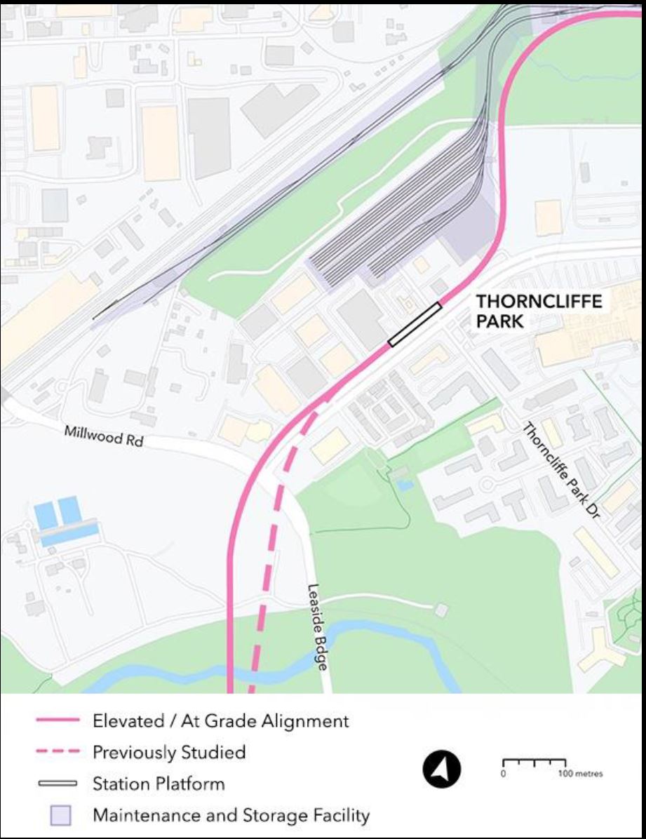
Since the previous update, there has been a minor change in the alignment near Millwood and Overlea. The Don Valley crossing has been shifted slightly and the entrance to Thorncliffe Park moved to the north side of Overlea Boulevard. This is simpler to build because only Millwood must be crossed, and it moves the structure further away from residences on Leaside Park Drive.
The alignment east of there including the MSF layout is unchanged.
Questions were led off by Councillor Jaye Robinson who asked what Metrolinx was doing to respond to City Council’s motion asking them to review alternative sites for the MSF. This gets us into interesting territory. Within the presentation deck Metrolinx says:
[Re] Community request for more information about the MSF site selection process and a re evaluation of alternate sites.
A technical analysis of alternate sites is being conducted, and a technical response is being prepared in response to community questions.
Presentation Deck at p. 16
However, in a recent letter to Council from Metrolinx CEO Phil Verster dated June 14, 2021, he explains at length why the current site selection is the correct one and gives no hint that Metrolinx plans any shift in their position. Even worse, he discusses shortcomings in alternatives that do not match the version put forward by the community.
For the Wicksteed site, Verster talks about the near-impossibility of shifting businesses now on the north end of the site, but this is a location that Metrolinx does not plan to use. The maintenance building will be on the southern part of this site.
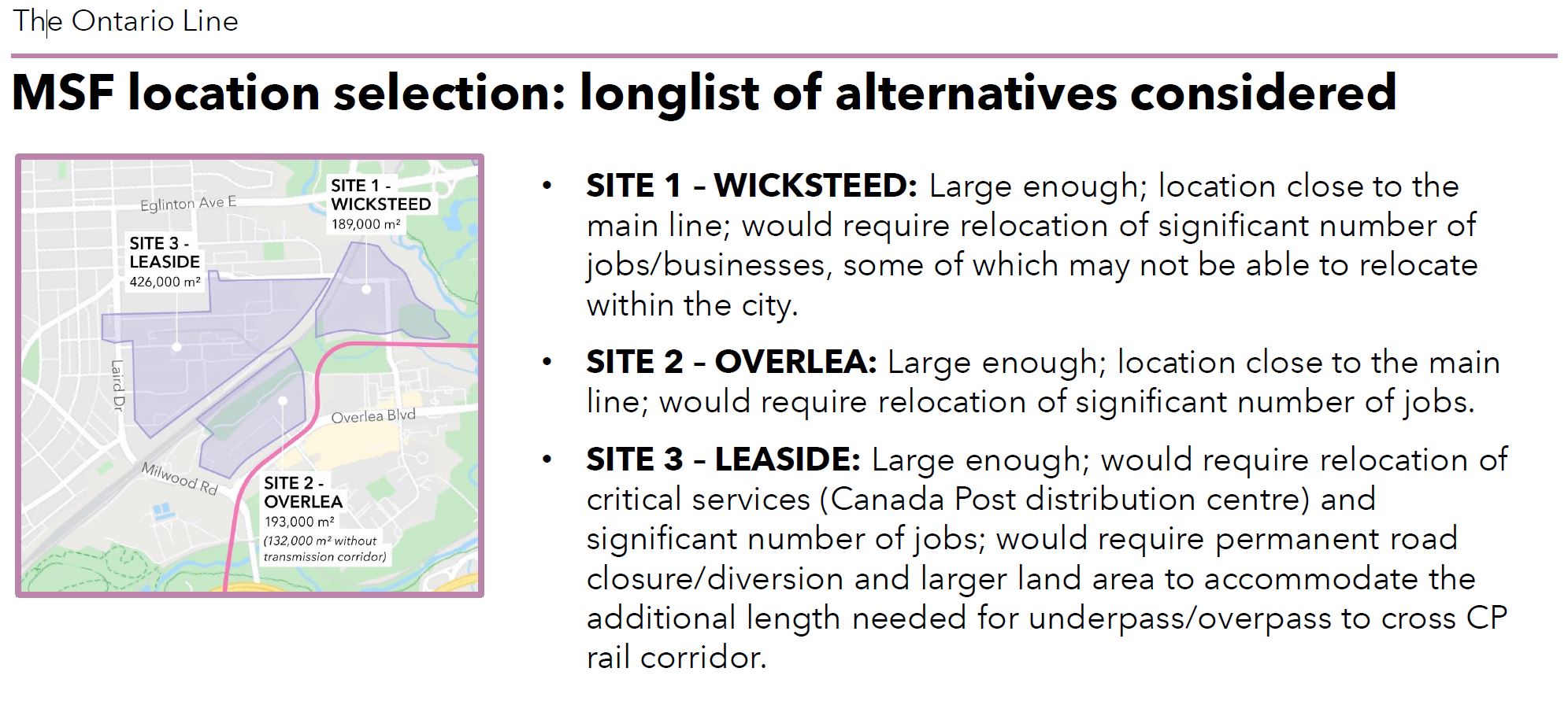
For the Leaside site, which Verster mentions only in passing, the analysis is shown above. Again, Metrolinx considers only an all-or-nothing situation taking the Canada Post distribution centre.
For readers’ reference, here is a satellite view of sites 1 and 3.
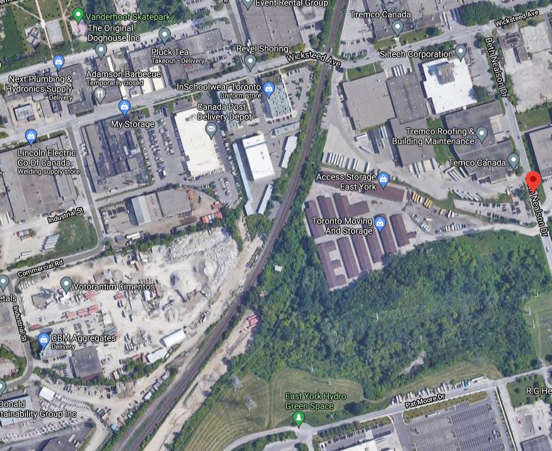
The northern part of site 1 (Wicksteed) is occupied by Tremco and Siltech which Verster mentions. They have advised Metrolinx that if they were forced to move, they would probably cease operations.
Metrolinx began discussions with Tremco and Siltech in Fall 2020, and through these discussions we learned that a relocation was not feasible for either company and that expropriating the land could lead to the businesses leaving not only the City, but possibly the region or the country entirely. The supply chain and indirect job impact of this would be at least 4-5 times the impact of the direct jobs (estimated impact on direct jobs at 800-900 employees), with very few of the total of the affected direct and indirect jobs retainable or replaceable.
Letter from Phil Verster, CEO of Metrolinx to Derrick Toigo Executive Director, Transit Expansion Division, City of Toronto, June 14, 2021
This is the sort of language intended to strike fear into Councillors’ hearts, but it is a red herring because Metrolinx is not planning to use the land where these companies are now located, only the southern portion now occupied by a self storage company.
Similarly, on site 3 the Canada Post depot is on the north side of the property and could be left intact if only the southern portion containing a concrete yard were taken for the new rail yard. Metrolinx does not even consider that option, but turns its attention instead to site 2 which is the source of much opposition in the community.
In the online session, Project Sponsor Malcolm MacKay said that community outreach is vital for the MSF. Metrolinx has a “robust” table with community leaders. They are looking at moving Thorncliffe Park Station further north and at the MSF site selection. They are working through community suggestions and will respond, and are taking the council motion as well as community into account, while trying to get the “best possible outcome”.
In a followup question, Councillor Robinson asked if Metrolinx will hold a dedicated meeting for residents of Thorncliffe Park about the MSF. MacKay replied “definitely” and that “we’re all ears and take what’s said seriously”.
To a question asking if Metrolinx would acknowledge that Thorncliffe Park does not want the maintenance yard and commit to looking at alternatives. Metrolinx replied that they have “a quite healthy process underway”. They want to understand why Thorncliffe Park does not want what is proposed, and work together with community to get a “beneficial outcome”. This is a commitment “by the highest levels of our organization – as good an outcome as possible”.
Metrolinx needs to get its message straight. Either they are actively considering an alternative to site 2 for the yard portion of the MSF, or they are simply going through the motions for the appearance of community “consultation”.
One might generously suggest that they had a change of heart about a hard line on the MSF site selection between the June 14 letter and the June 30 community meeting.
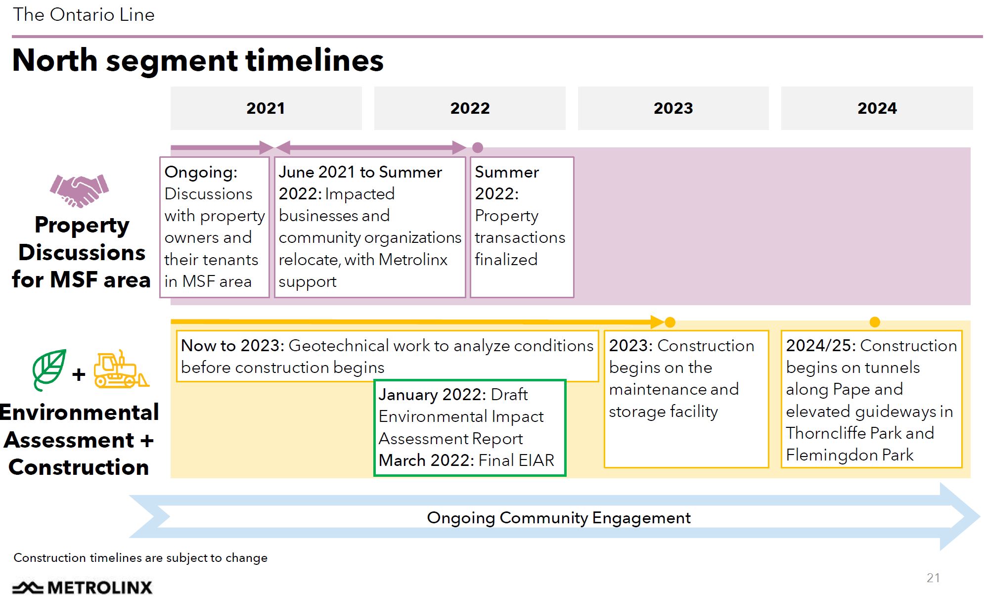
Meanwhile, Metrolinx continues discussions with businesses that will be displaced by the proposed yard site with a view to having them moved elsewhere by 2022. (See the project timetable later in this article.)
A few questions were posed about Pape Station.
- Will its platforms be large enough to handle the interchange traffic with the Danforth Line 2 subway, by analogy to crowding conditions today at Bloor-Yonge. Yes, the station is sized for the future AM peak hour demand.
- Metrolinx plans a station exit on Danforth from its new station that lies east of Pape. How will this affect the street? Metrolinx replied that they are still looking at specific property requirements. (There is an analogy here to the planned Osgoode Station at University Avenue which will have its own separate entrances at the ends of the new station platform, probably to meet fire code.)
MPP Peter Tabuns asked a set of three questions:
- An “Early Works” report was published recently. Where is it?
- Along the transit corridor, Metrolinx has identified a fairly wide area that could be subject to review for construction effects and interference. Can this area be narrowed and properties removed from the official “corridor” once the design is known in more detail?
- With the construction period extending to 2029, residents feel that the length of the notices on their property titles are unreasonable. Can these notices be removed when construction finishes in an area, rather than at the end of the project?
The Early Works report was for the Don River bridge and GO Transit yard at East Harbour and does not apply to this section of the project.
Metrolinx advised that there are “opportunities” on both scope and on time for the notices on title. They will take concerns about a possible phased approach or reducing the transit corridor land scope back to their “parent agency”. That’s an odd euphemism for the Government of Ontario.
At this point, Richard Tucker, Project Director for the Ontario Line, chimed in with an odd comment. He said that engagement with the community is iterative. Metrolinx expects to be engaged at each of these steps, and there will be many many opportunities for communities to be involved: Environmental Assessment, design, construction. This is just “the start of a long term relationship”.
There is a tiny problem here. Metrolinx has repeatedly shown that the relationship is very one sided and that all of the power is in their hands, especially once the project details have government approval.
There were also a few questions about the Don River crossing north of O’Connor Drive to Thorncliffe Park.
- There is a high water table on the south side of the valley that would affect the tunnel’s approach to a new bridge. Metrolinx is aware of this, but the tunnel will be in (or on) bedrock and will be sealed against water penetration.
- Can the line be routed over the existing Leaside Bridge instead? No. The bridge was originally built with extra support for a never-built streetcar extension to the Leaside industrial district, but that capacity was used up to support its widening from four to six lanes in 1968-69. Also it is not designed with a space for a lower deck like that on the Prince Edward Viaduct.
(For the historically minded, there is a Toronto Archives photo in the Wikipedia article about the bridge. The eagle eyed will see that the original poles have the telltale caps for TTC overhead poles of the period. The Bathurst Street bridge at the Nordheimer Ravine is a similar structure and could be widened because a planned streetcar line north into Forest Hill and beyond was never built.)
The presention deck includes a slide about noise walls, Metrolinx’ catch-all answer to concerns about noise. One issue about the storage yard is whether it will be built as a collection of elevated guideways or will be at ground level. There is no profile view of the site in Metrolinx’ drawings, and I have asked for clarification on this point. Note the relative scale of people and the proposed walls in the drawings below.

There is also the question of the physical presence of the elevated guideway through Thorncliffe Park where it will run along the north side of Overlea from Millwood to just west of Costco. Metrolinx offers various examples of structures showing what they aim for in design. It is ironic that they do not show Vancouver’s SkyTrain system, much beloved by one of their senior consultants, but instead show conventional light rail and even commuter rail structures.
These might be “light” but they are hardly unobtrusive, and only one example is shown with a station structure. The Davenport Diamond bridge is pictured at a great distance to minimize its physical size which will be considerably more imposing close up. As for the San Giorgio Bridge in Genoa, it is a new six-lane road bridge, not a transit bridge, that was built to replace one that rather infamously collapsed in 2018. The view here shows the bridge at a distance minimizing its physical mass.
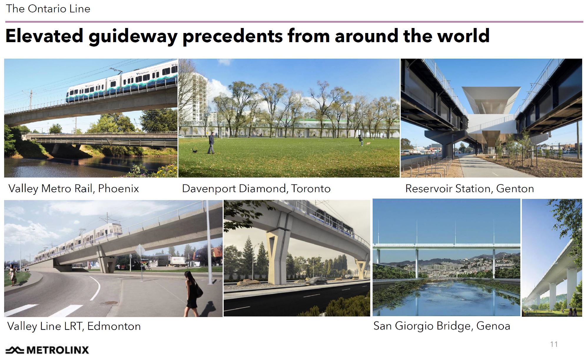
A very common practice for defenders of elevated guideways is to show them in the best possible perspective, preferably without station structures and from vantage points where their visual effect is minimized. Metrolinx needs to show mockups of designs in the locations where the guideway will run so that it can be understood in context.
Finally, here is the project schedule in its current form. One important event not shown is the June 2022 provincial election. Whether any incoming government, assuming the dispatch of the Ford Tories from power, will attempt to revise this project is difficult to say. Neither the Liberals nor the NDP have made any statement on the issue. Part of the debate will be moot by then, however, as the businesses will already have been moved out of their current locations.

For anyone else baffled, the “Reservoir Station, Genton” appears to be on Melbourne’s Mernda line, in Reservoir, Victoria, Australia. Genton are the architects.
Steve: Yes, I found that when I looked it up. A rather baffling choice when the main claim to fame is not the guideway, but the station architecture, something we can reasonably assume Metrolinx will not attempt to duplicate. That whole set of samples appears to be put together by a rather amateur choice of illustrations which tell us nothing about what might actually be built, rather like Metrolinx itself.
LikeLike
Thanks for the insights. I’m trying to reconcile your and Metrolinx’s assessments of Site 1 (Wicksteed) of the MSF.
You claim that MSF/Metrolinx only requires the area presently occupied by the Self Storage company, by my estimation about 40% of the total, ~75K sq/m. Implicit in your assertion is that Metrolinx’s need for 190K sq/m is a dodge (though the other sites are at least that large as well) and inflating the MSF area requirements is a tactic to preclude alternatives to its favoured Site 2. Has Metrolinx published material on how the MSF will use the property? What is the basis of your claim?
Steve: Compare the layout of buildings and track with the actual area of the sites. Also note that Metrolinx itself talks about using a hybrid Wicksteed-Overlea configuration to get enough property while avoiding the employment lands in the northern portion of the Wicksteed site. It is Metrolinx itself whose plan shows that it is only taking the self storage company’s land. It is not my “claim”.
Peripherally, and possibly bearing on site suitability that’s not touched on in your blog, is the topography of Site 1. Immediately bounding the self storage site on the south is large ravine and creek (by which the elevated line will be routed) — it’s easily visible in your satellite shot. This presents construction challenges and increases costs should Metrolinx, against your contention, need more than the restricted footprint of the self-storage site either now or in the future.
Steve: Yes, Metrolinx does not seem to address that little problem. But then, when I consider that one of the architects of the Ontario Line also “designed” John Tory’s original SmartTrack using out of date satellite views of Mount Dennis and Eglinton West, and completely missed the huge elevation difference between the rail corridor and Eglinton west of the Humber, this does not surprise me one bit. They’re great at lines on maps and sorting out the details later.
LikeLike
I attended the “meeting” and was livid that they essentially told the renters of Cosburn we’re useless and won’t be listened to.
There are thousands of us living in the area who will be affected by the businesses that will need to close for the construction of the station but there was no information to be shared about that at all, nor where the businesses along Pape that will be affected.
Typical Metrolinx.
Absolute bollocks.
The damned MSF should have been its own meeting.
Steve: Yes. They now have a separate meeting, but concerns of people elsewhere on the line didn’t have time to be aired.
LikeLike
Ok, found it. Slide 14 of the deck. I see what you’re referring to. You’re absolutely correct: the hybrid (Site 1 & 2) proposal only uses the southern part of Site 2, roughly the self storage property as you noted.
Unfortunately, what the hybrid site doesn’t do is nullify the main bone of contention from the neighbourhood which, if I understand correctly, revolves around the expropriation of a nondescript strip mall at Thorncliffe and Banigan. It runs parallel to the hydro corridor between Sites 1 & 2. There’s a dozen mom and pop shops here which cater primarily to the local Muslim community which considers them culturally vital. I believe the Mosque across the street is already slated to move. The Hybrid Site and Site 1 still require demolition at these locales.
I come at this from the perspective of a local (just south, off Pape) who over the decades has grown frustrated — who hasn’t? – over the farce that is Toronto transit planning. I’m very familiar with the OL North Segment neighbourhood and am trying to understand the opposition and Metrolinx’s responses in what’s seemingly such a favourable industrial corridor for building a transit line and MSF site.
Thank you for shining light on the subject.
Steve: Metrolinx has a bad habit of presenting its arguments selectively so that it sounds as if it is being ever so reasonable while completely missing the point. It is a favourite tactic to paint the “complainers” in a bad light while appearing to have addressed their concerns. The trick is so subtle that half of the Metrolinx folks, who are junior and don’t know the history, don’t realize that they are misleading the very public they claim to be helping. And if they do know, well, there’s a word for people like that and they should not be on the public payroll.
LikeLike
If you pull up the detailed diagram of the Metrolinx preferred Maintenance facility, it is comprised of 3 areas. The portion adjacent to the CPR tracks (part of Site 2) takes up about 2.8 ha. The area to the north at the storage buildings (part of Site 1) takes up about 4.6 ha. The area right in Thorncliffe (part of Site 2) takes up about 4.2 ha.
I am not sure how busy those CNR tracks are, but I hazard to guess not so much and that you can built a bridge under it for about the $10 to 20M range. Now you can look around on the north side of the tracks to find the 4.2 ha. to make up for not taking space from Throncliffe. Lo and behold, the Concrete yard itself appears to be about 5.5 ha. Metrolinx might say they don’t want such an orphaned area, but it must be noted that the current plan is similar with the 3 separate segments connect by 1 (maybe 2) tracks.
I am not certain if the community and/or Councillor are clear on what they want. Is it vague and just to change everything, or is it specific enough to only request the Thorncliffe portion to be changed? Maybe it’s a moot point anyways, because even if you specifically come up with a feasible alternative, Metrolinx will skate around the issue and not consider it.
Steve: First, just for accuracy, that’s the CPR and it is their main line across Toronto. That said it should be relatively easy to bridge over considering that the OL will already be in the air on its guideway as a starting point. Very little of an approach ramp is needed on the southeast side of the rail line.
There will be much weeping and wailing I’m sure about the concrete yard and industrial property around it, but I am willing to bet that inside a decade, there will be intense pressure for this area to become high density residential. This has already started up at Eglinton and to a lesser extend down Laird, and with two rapid transit lines (Ontario and Eglinton) in walking distance, this will all be hot property. Metrolinx might think about including a pedestrian bridge in whatever they build over the rail corridor to access their yard (they would need it anyhow for staff).
Down on the waterfront, there was a similar issue with the Lafarge Concrete plant on Cherry Street right in the middle of the new Villiers Island. They were planning to stay there, but then a deal was reached with the City for a land swap so that they could build a new facility (something they were planning within the next decade anyhow) on a site at the east end of the Ship Channel. This means that they retain access to the lake for marine deliveries and they stay in the same general area for truck access.
If Metrolinx really were serious, they would prime the pump for redevelopment by using this land for housing above the yard area. But they only talk “transit oriented development” when it suits them such as at Corktown Station.
LikeLike
I am fascinated by the two tracks that run north of the green area with the stream and go along the CP line across North Toronto heading to the west. Is Metrolinx planning a line along the North Toronto Sub to the West or along the Belleville sub to the east. It seems to serve no useful purpose unless it is needed to come down from the EL. I think we should refer to it always as the EL as it will probably piss off Verster and Metrolinx who will say “It is nothing Like the old ELs in the US”.
Strange lit lines like those in the photo always intrigue me.
Steve: These tracks double as a delivery track from the CPR mainline and access to the wheel truing facility which will be on that segment.
LikeLike
The new bridge alignment looks like it also gains some extra length for the climb up from bedrock on the south side to >5m above grade before Millwood Drive.
Did they have any information about clearance from the high voltage lines that into the valley from Leaside TS?
Still seems like shallow cut-and-cover on this alignment would result in a quieter/nicer street, and give more options for MSF access like crossing under the rail corridor for a split yard.
Steve: Metrolinx has never talked about the hydro lines that cross the valley in the same location.
LikeLike
MX clearly doesn’t want the Site 3 Leaside option. This option is twice the size of Site 1 or Site 2, and they are treating it as all or nothing, even though the variety of uses (concrete plant, self storage, Canada post) suggests it may even be separate parcels with separate owners.
Was any real consideration given to making a 2-level facility? Lower level at grade for maintenance functions, but run some elevated tracks through for storage? even with limiting grades for rail, there’s ample space to get the levels to diverge.
For the amount of storage needed, they should also be able to fit some (or all of it) by adding a third track along certain segments of the line where it is inexpensive to build and the right of way is wide enough. Vancouver’s millennium line does this in places. This should also include some storage at the west end of the OL, to avoid lots of deadhead miles at the start and end of the day, which also indirectly allows longer traffic free periods for maintenance. As a fully automated transit line with no onboard drivers, it shouldn’t matter where most trains get parked!
LikeLike
Is there any provision for expanding the yard for increasing service or extending the Ontario Line. An extension to at least Sheppard seems inevitable.
Steve: Metrolinx claims that the yard is already sized for expansion of demand, albeit on the basic line. Now that the government has announced an immense extension (not that I believe it will ever be built), there should be plenty of land elsewhere for another yard or two.
LikeLike
Thanks again Steve, and commenters, as we’re seeing again this massive ‘work’ based on it feels like really limited options and assessment for options, including cheaping out when there are billions being splurged or wasted elsewhere eg. SSE, Eglinton W LRT burial, though it is likely that LRT project wasn’t that high of a priority project before Mr. Ford ‘torque’ over.
So this feels like it’s discussing the wrong details on the Torontic, when somehow, we should be getting the staff/bureaucrats to follow through on that last OP of Metro that urged an EA study for linking up GO with whatever Relief might be built up to Eglinton, which is needed. Except we are in dire need of a triage project that is far simpler, and more direct to link Thorncliffe area to the core via mostly surface routes/options, in a far more open and imaginative process than what we’re being subjected to, which is tending to benefit suburban interests and political interests far more than core interests and the public interest.
Cast of characters to lay blame on including all three governments and all three major parties, and what a shame that the 1957 plan – using Donlands for that ‘Relief: – wasn’t done. Having transit on Eglinton was also part of that plan – 60 years later, almost being completed, and that is another reason for the triage approach: if Eglinton gets new riders beyond what returns, we don’t seem to have contemplated that many will wish to transfer eg. at Yonge, which means a further overload (if riders return to Yonge), so unsafe conditions will be present for how many years?
Further, the OL is being used to allow further extension of Yonge even further to the North, making what is already a burdened spine (or was prior to pandemic) even worse, and federal level $$$ has helped with that ‘planning’ of technical details of something wrong, again. So in terms of deflecting a bad process and likely clunker project where we really should be having a high quality line, the federal level now deserves some castigation, despite the hard works of some of the local MPs. While transit is complex, the shitizens who are using it and paying for it really deserve better results, including a focus on silver buckshot not the alleged silver bullet with this megaproject is, though we need more robust transit in a network, even with the vast decline in GO riderships especially.
How to explore triage options, especially the triage of mostly surface via Don Valley?
LikeLike
So they completely ignored the stretch Pape – Gerrard? Do you have any info about the portal on the bottom of Pape? The area is far from perfect now. Will it be worse for pedestrian crossing to Gerrard square? Plenty of older people living at Francis Beavis manor 369 Pape. Will they face the concrete wall or eat the extra noise?
Steve: There was a small amount of discussion of the Gerrard Portal an the East Segment consultation, but no discussion of anything south of Danforth during the north section meeting. Crossing to Gerrad Square at Pape should not be affected because the portal is on the west/north side of the rail corridor, the opposite side from Pape/Gerrard. The larger community issue here is that the whole site is likely to be under redevelopment pressure because it will sit on top of a subway station. Whether Gerrard Square as we know it will survive is anyone’s guess.
LikeLiked by 1 person
Hi Steve. I read your reply to Jarek, where you said the illustrations tell us nothing about what might actually be built. Metrolinx has released a “Subway Station Architecture Design Standard” to guide the architecture of their projects… and even includes concept renderings of some Ontario Line stations.
In my opinion, it is very disappointing as they chose a very minimalistic & modernist style instead of going for more contextual and colourful solutions. The fact that they didn’t consult anyone on the general design aesthetic of stations shows how little Metrolinx thinks of people’s aspirations for our city. Considering that we have been getting way too much cookie-cutter garbage, this is a chance to make our city more aesthetically pleasing. Metrolinx isn’t really trying to build attractive stations of which we can proud.
Steve: It’s amusing that the TTC went through cycles of bare-bones “bathroom” stations, then the architectural wonders (at least at street level) of the Vaughan extension, and now we’re back to simple designs because we shouldn’t be “wasting money”.
Somebody made a lot of money putting that design standard together and it will be interesting to see how closely it is followed once people get a look at those cookie-cutter stations.
My concern is with the specifics at each location. Metrolinx is fond of saying that this is up to the P3 contractor who will build the stations, and yet some discussions of station massing, access and circulation are essential to understanding projects before they reach the stage of letting construction contracts.
LikeLike
What exactly is the track grade from the south side of the valley to the elevated structure on the north side?
Steve: Metrolinx has not published a plan. However, one can make an estimate using Google Earth to pick out elevations of nearby streets.
Street level at Minton Place (south end of the bridge) is 118m. (The DVP just north of it is at 94m.) Millwood and Overlea is at 119m, and so the run across the valley is close to flat (there is no grade to speak of on the Leaside Bridge either). Therefore the delta will be from the depth of the tunnel to the top of the elevated structure with maybe a metre extra for change in elevation. Assuming that the tunnel is at least 5m underground (relative to nearby streets) at the portal, and adding maybe 3m for the distance from top of tunnel down to top of rail, this means we start at about 8m below nearby surface level. The elevated structure will probably be about 8m to top of rail, albeit maybe a bit less crossing Millwood where the minimum clearance for the structure would be 5m and the track beam and rails on top of that. This gives us a climb of 16-17m across the valley.
The crow-fly distance across the valley is about 580m, and this gives roughly a 3% grade on average. That is steep but not impossible (the Yonge subway between Summerhill and St. Clair is 4%). That’s without looking at what might be in the way, notably hydro lines, on the route across.
LikeLike
At its April 19th presentation, Metrolinx said the Minton portal would be 14m below the surface. See question & response at 26:10 in the video.
I’d guess that’s measuring to the bottom of the tunnel because otherwise it’s a prohibitively steep crossing. It still seems quite deep, but would match up with the tunnel alongside Pape being 20-30m down, presumably to keep most of the tunnel boring down in bedrock?
Hopefully they’ll take the opportunity this bridge creates to include a bike/foot path connecting from Overlea/Millwood down to the east Don trail.
Steve: That’s a good point. If the top of the tunnel is 14m below the surface, that’s 9m more than I was allowing. The grade would then be roughly 4.5% which is really pushing it.
Metrolinx creates problems with understanding their plans over and over by failing to publish technical drawings claiming that they will come later when they must already exist in order to make some of the claims they do comparing the OL to the Relief Line proposal.
LikeLike
Looks like 4.5% is possible for an extra long magic run but impossible elsewhere like Riverside?
Metrolinx would never do such a thing…
LikeLike
I live here and don’t know the version put forward by the community to Metrolinx. Maybe it is only shared to some people in Thorncliffe. Can you write a new story for it?
Steve: The main variant was to bridge over (or tunnel under) the CPR and establish the yard in the south side of the “Leaside” lands where the concrete plant is now. Metrolinx only talked about this option in an all-or-nothing fashion including the Canada post building at the north side of this site. They did not look at leaving the carhouse (the “MSF” building” where they planned it on the south side of the Wicksteed site, and putting the yard on the other side of the CPR. After all, with automated trains, it’s not as if staff have to go over there for every train movement.
Metrolinx is quite selective in the variants they consider while they claim to be open to looking at changes.
LikeLike
Are you planning to do any reviews of the SSE and ECWE?
Re SSE: At an online meeting, a questioner asked whether there would be provision for an LRT eastward from Sheppard & McCowan station. A panelist did not answer the question directly saying that there would be provision for the Sheppard subway to terminate at the station and provision for a Line 2 extension further north. Was the City thinking of extending the Eglinton East LRT to Sheppard & McCowan?
Re ECWE: It appears that in order to build the Kipling & Eglinton station on the north-west corner of the intersection, a chunk of the wooded area at that corner would need to be demolished. Metrolinx wouldn’t say how much. There appears to be fewer trees on the south-west corner; so I don’t know why Metrolinx it doesn’t build there. This is in addition to the tree-cutting at Osgoode Hall and in the Don Valley on other projects.
Steve: I was not planning to write anything on the SSE until there is some real news such as details of land requirements for stations and emergency exit buildings. The current issue on which I wrote recently is the matter of Line 3 replacement service from 2023 to 2030. But Scarborough is getting the screwing the subway advocates deserve so much. Sadly, the people who will be hurt by seven years of bus service are not all subway advocates.
There are also many related TTC projects (collectively the “Line 2 Renewal”) that need to get their ducks in a row so that the SSE can open, notably a new fleet with ATC capability, and probably a new yard at Kipling. Rick Leary had pushed a lot of this work off into the future to make the Capital budget come out right, but some items have been moved back into the 2020s notably new signals and trains.
Re ECWE, I had not heard about Kipling, but it doesn’t surprise me. The station has to be on the north side because that’s where the right-of-way and the tunnel are. Of course if they had done a surface line in the middle of a widened Eglinton, this would not be an issue.
The new houses on the NE corner make that a crowded site, hence the west side station building. These of course are the houses the bozo who “planned” SmartTrack using out of date Google Street View images didn’t know about when he proposed a commuter rail line along Eglinton. This is the quality of “planner” we put in charge of major projects at Metrolinx.
Both of these projects are travesties of politics trumping good planning.
LikeLike
Thanks for your answer. However, according to a map in the neighbourhood update, the line would be under Eglinton Avenue at Kipling Avenue, whereas it would be on the north side in most other places. This is why I felt that an entrance on the south-west corner would be feasible, although there would be less space than cutting down part of the wooded area at the north-west corner. But then it seems the SmartTrack consultant had planned to chop down the wooded area for a railway line; thus, perhaps Metrolinx feels it can do the same for the ECWE.
Steve: Thanks for pointing that out. I had missed that Metrolinx did a community meeting a few days ago. Looking at the intersection layout, the north side appears to be an easier target (the trees don’t complain much) and absent a lot of hollering from the locals, Metrolinx will make short work of them.
LikeLike