
In a recent article Metrolinx Plans Major Grade Change on Lakeshore East Corridor I noted that a new set of drawings had appeared in the Ontario Line Neighbourhood Update, East web page showing a proposed change in the elevation of tracks in the shared GO/OL corridor between East Harbour and Gerrard Stations.
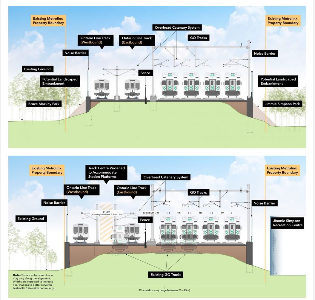
Here is a Metrolinx illustration showing the change. The layout as originally proposed is on top, and the revised layout is on the bottom. Note that where green space is shown neside the corridor, this does not necessarily exist as some of the Metrolinx property line is at or close to the sidewalk. The retaining wall plus noise barrier would be immediately adjacent.
I posed a series of questions to Metrolinx in an attempt to sort fact from fiction on this matter, and today had a call with their project staff to sort through the issues. The principal speakers for Metrolinx were Malcolm MacKay and Richard Tucker.
When was the decision made to regrade the rail corridor? Why is this being done?
According to Metrolinx, this has been underway for at least 6 months as a collaborative effort with the TTC and City of Toronto to establish bridge clearances and other design elements.
Substandard clearances are a concern on the road network for both the City and the TTC. Those of us who follow TTC service interruption reports often read of “mechanical problems” near Queen and DeGrassi Streets. These are almost always due to damaged or broken overhead thanks either to a dewirement, or to an over-height vehicle striking the TTC wires.
A related concern is that the bridges in this corridor are about a century old, and this is an opportunity to replace them with new structures that will have lower maintenance costs
Later in the conversation, I asked whether Metrolinx was saying, in effect, that “the City made us do it”. To this they responded strongly that they are not blaming the City, but there is a 5m standard for bridge clearances that they are following. They went on to say, possibly imprudently, that there were pro and anti camps on the question of whether this work should be done.
Obviously the pro camp won out, but drawings showing the change are quite recent, and there is no mention of this in all of the studies that have been published.
What is the extent of the work, i.e. between what locations will the track be raised from its current level?
From east of the Don River to Gerrard Street. According to Metrolinx, he TTC still has an interest in the Dundas Street bridge because they are protecting for an extension of streetcar service to Gerrard Station via Dundas and Carlaw.
By how much will the track be raised?
The change varies by location, but it will be between 900mm and 1500mm according to Metrolinx. For those who still think in Imperial measure, that’s just under 3 feet to just under 5 feet.
I asked whether a plan showing the new elevations exists in the style of “roll plans” that have been provided for other corridor projects. This will probably be published along with other details for the next round of public consultations later in 2021.
What are your staging plans for maintaining GO service during this work?
Metrolinx would likely slew the existing GO tracks to create work space on one side of the rail corridor at a time. This would allow all work to be done within the corridor rather than using adjacent spaces. Metrolinx’ property is wide enough for six tracks, and this means that three could be maintained in operation by shifting them to one side while work was done on the other side. There are no switches in this segment, and therefore shifting the tracks is relatively straightforward.
If low ridership on GO continues long enough, it might be possible to reduce the corridor temporarily to two tracks giving more room to work around the live operations.
What are the effects on the bridges in the affected area?
The bridges are old dating back to 1924. Metrolinx intends to replace them with new structures regardless of whether they are owned by the City or Metrolinx.
The elevation change will be entirely at Metrolinx track level. The road elevations will not change.
When I published my article, a few emails arrived suggesting what was behind this change. One claimed that the High Frequency Rail (HFR) project wanted a different track standard to support their planned operating speed. This seemed a bit far-fetched considering how close the tracks in question are to Union Station, and how short (2km) the segment is. The change in travel time from Toronto to Montreal would probably be measured in seconds.
Can you confirm or deny that at least part of the reason for the regrading is to suit HFR? If so, does the intent to use “tilting” trains change the spacing of the tracks needed for clearance?
Metrolinx replied that HFR did not play into decision making for rail heights or tilting trains. The alignment is designed to Metrolinx standards. They are not precluding HFR, but not changing bridges or track layout on HFR’s behalf.
A Question of Transparency
I will take it on faith that the City and TTC really have been working with Metrolinx for half a year on this matter, and that there may have been a debate about whether regrading the corridor and raising the bridges was actually necessary.
That said, Metrolinx published extensive studies and community presentations showing the corridor at its present elevation, and with no provision for the construction effects of rebuilding the segment from the Don River to Gerrard, not even a mention as a possibile subject for further study.
There has been no evaluation of the construction effects, and proposals regarding mitigation of the combined OL and GO effects here are based on current track elevations. This affects sound barrier heights and the amount of room available for corridor “softening” with treatments such as vegetated slopes or additional trees where room is available for them. The drawings purporting to show what the corridor would look like simply do not match what Metrolinx now plans to build.
All this is not to say that raising the corridor and improving clearances are, on their own, bad ideas. It would be refreshing to have fewer service interruptions on the streetcar network here, especially considering that over half of the fleet is based just east of this bridge at Leslie Barns and Russell Carhouse.
If this has been a City and TTC concern for months, why does the local Councillor not appear to know this could be part of the project scope?
Another obvious question must be what effect this will have on the project’s cost and duration. Who is picking up the tab?
One cannot help wondering whether it is only good fortune that this design change came to light during the current round of consultations.
What else don’t we know about Metrolinx’ intent in this and other corridors?
All of the debates about the project until now were based on a false presentation of how the enlarged use of the rail corridor would affect the neighbourhood.
This is not just a question of settling a debate among “the experts” about whether to raise the rail corridor or not. This is not a minor scope change. This is not an “oops”.
Even with the best of intentions, the basic issues are transparency in public consultation and trust in Metrolinx.

Is there an extra not in that (or maybe the bad should be good)?
Steve: Thanks for catching the extra “not”. That sentence was edited a few times.
LikeLiked by 1 person
As useless as Environmental Assessments (EA) are, EA’s would be beneficial. I believe that Better Transit Faster Act and Bill 107 diminish public input.
LikeLike
Steve, what does “slew” mean in this context?
Steve: Swing the live tracks over to one side of the corridor while they regrade the other side.
LikeLike
Increasing bridge clearance was the first thing that crossed my mind, then dismissed due to the cost and time it would take to do it.
If the City found it an issue, there would have been reports and possibly plans to drop the road level, the limiting issue usually being services buried under the road like sewers.
Here’s an interesting example of exactly that, a sewer line limited how deep the road could go.
In this case, the City [Guelph] picked up the entire tab, albeit this was before Mx took ownership of that stretch of track. Councillor Guthrie later became Mayor.
I find the reason of bridge height being proffered as very odd, in light of circumstances. Unless huge assumptions are accepted, this still doesn’t add up.
I’m sure Mx will be forthcoming with the figures to justify this course of action?
Steve: Yes this is all very last minute and does not smell quite right. They plan to have cost estimates for the regrading and other issues for the next round of consultation which will be in July-August.
LikeLike
Wondering if to save money, they’ll go with on-street transfers or will a couple of stations have some sort of off-street transfers? They may work fine at opening, but what if the stations’ transfer capacity require expansion. For example, the 72 PAPE bus south of Gerrard Station maybe extended into the Portlands, even upgraded to a streetcar.
Steve: There are no off-street loops at the three stations in this area, and few on the line overall. 72 Pape as a streetcar? I very much doubt this.
LikeLike
Has anyone checked the wire height and clearances on other electric commuter operations? Wouldn’t that be helpful? AMT/EXO in Montreal would be one choice. Plenty of USA operations as well.
Steve: There are standards for clearances from the overhead. Metrolinx is using the Canadian standards for such things. The bridge clearances that are the issue here are the clearance to the rod under the bridge. Queen Street is 3.8m and the standard is 5.0m.
LikeLike
Of all the four Ford transit schemes, the Ontario Line has been the one which has a core need of some validity – Yonge especially needs some Relief, though I fear the semblance of Relief becoming a reality will let the schemes for further extension gain more momentum, and yes, federal Liberals are also part of that problem.
So now Steve has found a Major wrinkle, and one almost wishes that the phone conversations were taped, because hard info may be scarce.
Is this wrinkle an extra $500M? Or a billion? Or $2B? While the majority of pols involved aren’t really perturbed about the billions, (and some in enviro camps are silly to also think that Big Spends actually bring value), with all the various $hortfalls and problems around, plus the many impacts on the local communities from this proposed shoehorning in of OL to this bit of corridor, surely it’s time for a real reset/evaluation of what Relief options are possible.
This should include surface options of many routes in the Don Valley, including that of the last Metro-era OP, but also toss in the DVP etc., which could actually lead to another direct linear route, possibly ideal for semi-express transit in to the core. (We need semi-express/express).
It’s also ‘fascinating’ to hear/read about the official worries about ‘substandard’ facilities. The City/TTC has had NO problem rebuilding substandard/narrow McCaul St. with dangerous tracks that can harm cyclists, and they’ve just redone substandard/narrow Grenadier from Ronces to DDW I think, and while we could be making Queen St. far far safer for westbound cyclists especially by a unique chance to move tracks north from c. Niagara to Brock, since they’ve only had 20-ish years to notice a structural death/injury pattern, why expect change?
Lower Ossington south of Dundas to Queen St. is also substandard width, but there’s lots of parking revenue, as is the case with McCaul as well.
And there are substandard pinch points in far too many locations to list, but they’re real. Even with a death, oh well. And isn’t most of our road system substandard in Vision Zero terms?
There’s also a very widespread substandard condition of both roads and track margins. Even not-Metrolinx rail bridges are maybe getting dodgy; and the southbound Yonge St. curb area is possibly deadly dangerous to a downhill cyclist in winter as the water seepage turns to ice and one can’t see it, but it may be safer with a bike lane now.
Along with a pause and reset for options to the OL, (as dire as the climate emergency needs are, and we’re sorta lucky pandemic dropped riderships), we must do better Environmental Assessments – specifically measuring concrete usages as it’s got a GHG footprint of about 7% globally. One eg.: I note a new massive concrete ‘noise’ or perhaps safety barrier on south side of CP tracks near Howland. So maybe a ‘greener’ solution is less speed?
The Ford/Con government isn’t really worried about conserving the billions, and may want to have a few transit follies to have as a reason for cutting all sorts of things because they can and want to. And it’s a shame that we have such Wa$te when transit demands/needs are very real and costly, and sometimes unmet, like Eglinton E LRT as one example out of dozens.
Pardon length – and what’s a ballpark for additional costs, or has Steve hit it out of the park?
Steve: TBA. Come back in July or August and they will tell us, or so they said at tonight’s online session.
LikeLike
“…they are protecting for an extension of streetcar service to Gerrard Station via Dundas and Carlaw.”
Is this Dundas or King Car?
Is this one option or is there another they are considering?
I am thinking of Dundas Car north on Broadview to Gerrard and East to GO Gerrard Station.
Steve: No, the Dundas car via Dundas and Carlaw. The original design for Gerrard Station on the Relief Line included a streetcar loop, but it was dropped to save money.
LikeLiked by 1 person
What’s the general sense here? Is Metrolinx telling the truth here? Are they lying? Are they trying to be slippery with their answers?
Some of the comments from other contributors in the earlier thread concerning the stability and integrity of widened embankments were certainly eyebrow raising. I feel like the HFR question wasn’t necessarily the right one to ask.
If the hypothesis that regrading is somehow related to making room for 6 tracks plus platforms and physical segregation (and not having it slowly collapse) has any merit then surely it could be be proven.
It would be a bad look for Metrolinx if some engineering firm could attribute this sudden change to the napkin doodles that expert consultant Mike Schabas passed over to the people at 97 Front Street West.
Steve: I asked the HFR question to get the answer on the record. There are a lot of stories that circulate in the community of activists. Some are true, others less so. As I said in the article, I found the HFR idea not credible because of the minimal effect speeding up operations on 2km of track close to Union Station would have on overall travel times. But I asked to ensure that Metrolinx had not invented this as a rationale. The principal contribution of HFR might well be that we can pile up the studies along the corridor to build the noise walls.
LikeLike
This is something I have great difficulty believing. That Metrolinx is making a scene over 1m of bridge clearance but when it came to actual regulations and standards governing clearance between light rail and heavy rail operations they didn’t want to talk about it at all.
Steve: Although this is an issue, I have yet to see anyone point to a specific regulation or standard on this subject. If you know where it is, please provide it.
LikeLike
Something missing: the costs and benefits of lowering the relevant roads instead. I appreciate this isn’t trivial (drainage being a significant issue), but it would benefit Metrolinx to explain why the obvious alternative hasn’t been chosen.
Steve: Not just drainage. There are many utilities not far under the surface of those roads. Also, some locations are already underpasses with dips and making them deeper would affect the approaches. Even for a level street like Queen, going down 1.5m (4.9 ft) at a maximum grade of, say, 2 per cent, requires a 30m (98.5 ft) long approach on either side. That would also affect nearby intersections.
LikeLike
Thanks again, Steve and commenters.
With any lowering of the road, it’s also an extra effort for cyclists. And most underpasses are on the very nasty side already, though we’re seeing bike lanes go in sometimes, thanks.
With any possible raising of the tracks, if it’s low clearance of 3.8M vs. 5M, that’s a standard for larger trucks, a minority of vehicles, and usually private ones. So should they pick up the tab? Many of us in the core don’t mind if truck size and speeds are limited; and maybe it’d be waay cheaper to have some sort of automatic signal, somehow, to measure and convert height to a flashing light.
As for the ‘substandard’ comment – Toronto is a substandard City now, and likely has been from near origins as the main east-west roads are really narrow/tight for the demands upon them. We also have substandard policing of traffic rules/regs that cost lives, but these lower bridges haven’t killed anyone correct?
There’s also been a LOT of substandard planning, this being another case in point, and that’s substandard governance and polluted processes, where often the core is smarter on the vast sums than the suburban area reps, with the Mayor being part of the problem often.
So should ALL other work on Ontario Line be halted until there’s clarity on this important cost? Is there enough bad process/plan (not the technical details but broad strokes for the good folk doing the detailed work), that we should/must have a reset/pause of the plans for review of both tunnel options and surface?
The Amory Lovins phrase of ‘tunnelling through the cost barrier’ ie. being adept at cutting out an entire class of costs by, say, conservation/insulation, means in this instance some tunnel might be $marter, and the Smartest might be to squeeze the billions with focus on triage Relief function in the Don Valley on existing corridors as per old plans, including Metro and Davis/era.
With flooding issues, a drainage tax might help ease that surge, with about 70% of Don storm surge being related to upstream storm drainage, and there’s that massive project in view of Steve as well, costing $$$$. And there’s plenty of other works to keep construction interests very busy, not just repairs, (as a concept).
LikeLike
I confess that I went back and looked up the Transport Canada standards and clearances max out at 18 feet between tracks under certain circumstances.
I might have been thinking of the US FRA guideline for shared main line and light rail which is 25 feet between track centres. In the past when discussion about double-tracking the Stouffville line started and the question of available space came up, my examination of the SRT/Stouffville corridor yielded something close to that. I must have erroneously assumed there was a matching TC guideline in place.
LikeLike
The track work required in the GO corridor for the new OL alignment seems to be growing in scope. Is there a point where this new infrastructure will approach the cost of tunnelling for the OL? If so would tunnelling be a better option in regards to environmental impact?
Steve: I suspect that tunneling will always be more expensive, but the GO costs are rising too. The real question is what a GO design without the OL would look like and cost, as opposed to a combined facility. The idea of raising the corridor and replacing the bridges appears to be quite recent given that it appears nowhere else in Metrolinx plans or studies, and yet they claim it has been in the works for six months. Something here is very difficult to believe.
LikeLike
So, in the overall scheme equivalent to about $1.98! (A dollar 98)
Would it make sense (and save money) to route the Dundas Car via Broadview and Gerrard to Gerrard OL Station?
Steve: It would save money, but complicate operations because the Dundas car would be added to other streetcar traffic on Broadview (both the King and future Broadview cars) and would be turning onto and off of Broadview at two intersections. Going straight east on Dundas avoids this.
LikeLike
The idea of saving money on a financed project is always interesting…the money doesn’t exist until financed, and the benefits of the additional infrastructure will likely be greater than the costs.
I’m starting to imagine the benefits of going further east than Carlaw. There might be some benefits of a Dundas streetcar that went as far east as Coxwell, then run track north to join the College streetcar and/or south to Woodbine Park…or as far east as Kingston Road to link with the streetcar there.
LikeLike
The bicycle lanes should stay flat just like the sidewalk. Of course, our “engineers” don’t even understand that on a long bridge the big concrete barrier should be between motor and non-motor traffic, not between bicycles and pedestrians, so maybe the same lack of safety sense extends to underpasses as well. Of course, if there aren’t bicycle lanes, then that is a whole other discussion.
As to grade, somebody mentioned a 2% grade. That is steep for railway but I thought even superhighways could be at 6% or something. That being said, I can appreciate that especially where a road already dips going deeper could have a bigger impact than one would initially assume.
That being said, as Steve pointed out (thanks!), if there are inconveniently located sewers or other infrastructure, going deeper may not be an option.
Steve: I mentioned a 2% grade because Queen Street includes streetcar service. A quick, steep dip down and up under the rail corridor is not an ideal option, although it is possible (for example Bathurst Street north of Dupont). Another problem at Queen is that there are intersecting streets immediately east and west of the bridge. If the road is dipping under the bridge, these intersections will no longer work.
As for bike lanes at sidewalk level, that assumes one would take at least part of the curb lane for cyclists. It’s a four lane road and two lanes are already occupied by streetcar tracks.
It’s not a great wide autoroute like Steeles Avenue or other suburban corridors, but a tight area with limited “elbow room”. Some of the comments here imply that people are thinking in terms of the room available on wide suburban highways, not narrow city streets.
LikeLike