
Updated June 17, 2021 at 5:20 pm:
In the table of station usage counts, I cited the values as “all day” numbers in the original version of this article because Metrolinx own summary article showed the total value as “daily” not as “peak hourly” . I asked Metrolinx about this discrepancy, and they have not yet responded. However, they have changed the article in which “daily” was used to now say “busiest hour”. I have updated this section accordingly. Other questions to Metrolinx have not yet been answered. (Screen captures are included later in the article.)
Meetings for other segments are scheduled on:
- June 17: Central downtown
- June 24: Corktown, East Harbour, Riverside, Gerrard
- June 30: North to Eglinton from Danforth
The introductory article for the meeting is on the Metrolinx blog and the engagement page includes links to the four meetings and resources for them.
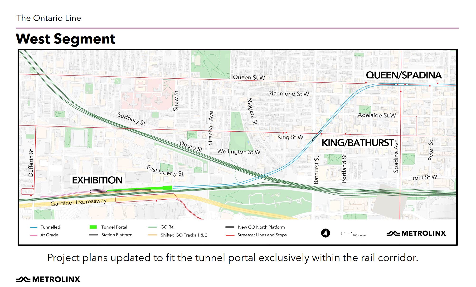
All drawings in this article are taken from the Presentation Deck for June 10. Street view photos are from Google Maps.
Project Schedule
A common question during the session was “when will this affect me”. The entire project is complex and will affect areas in different ways as it moves through its stages. The published schedule concentrates on pre-construction activities. In the chart below, related activities share the same colour so that, for example, the Lower Don Bridges are all yellow.
Early works that can occur before major construction include:
- Exhibition Station reconfiguration and expansion (construction to begin imminently)
- Lower Don Bridges (construction begins in early 2022)
- Corktown Station (no start date shown in the plan)
There are four big contracts that will affect neighbourhoods along the route.
- The Lakeshore East joint GO and Ontario Line corridor between the Don River and Gerrard is an “Early Work” scheduled to begin construction in the second half of 2022. This segment is controversial because of potential effects on affected neighbourhoods, and Metrolinx’ aggressive efforts to counter “myths” and “misinformation” about their project. See Metrolinx v Riverside: Where Does the Truth Lie?
- In mid-2022 contracts for the south segment structures and for “RSSOM” (Rolling Stock, Systems, Operations and Maintenance) will be awarded with construction to begin in 2023.
- The north segment structures contract will go to its RFQ stage in early 2022, with RFPs to selected proponents late that year. Contract award will occur in 2024 and construction would begin some time afterward.
For the south segment, the tunnels will be deep underground, typically about 30m down. They will be bored through rock starting from the west end of the line. Spoil removal and materials delivery will occur at the Exhibition with the tunnel portal west of Strachan Avenue and truck access to the Gardiner Expressway at Dufferin Street.
Stations will be built using a “keyhole” method by digging down from future entrance building locations and then mining outward to create station caverns for the concourses and platforms. This is similar to the approach used for a few stations on the Crosstown project to avoid excavating within streets. That is particularly important for locations where there are streetcar lines and many underground utilities.
The first stage of construction will be to tunnel, with station construction to follow once the tunnel is in place. Metrolinx has not published a detailed schedule, but station work would begin in 2024 in the south segment as tunnel work progresses from Exhibition east to the Don River. Metrolinx expects station sites to be under construction for about three years.
The major RSSOM construction in the early years of the project will be the Maintenance and Storage Facility north of Thorncliffe Park. After the tunnels and aboveground structures are complete, the RSSOM contractor will outfit tracks and systems, but this activity would largely be within the completed tunnels and guideways.

Station Profiles
Information about the areas served by each station appear in various places including the presentation deck, the Metrolinx blog, the verbal presentation and the West Segment Neighbourhood Profile which has the complete set. [This table was updated on June 14, 2021 to reflect the information in that profile.]
Updated June 17, 2021 at 5:20 pm: Metrolinx has updated their article about the Ontario Line to change “daily” usage for these stations as a group to “busiest hour”.
Here is the original text as seen in the Internet Archive:

Here is the text as seen on June 17 at 5:20 pm:

| Projections for 2041 | Exhibition | King/Bathurst | Queen/Spadina | Total |
| Residents served1 | 12,100 | 27,000 | 22,800 | 61,900 |
| Jobs served1 | 17,600 | 24,200 | 42,200 | 84,000 |
| Zero-car households1 | 2,700 | 8,700 | 7,900 | 19,300 |
| Station usage (busiest hour)3 | 12,100 | 5,100 | 7,200 | 24,400 |
| Transfers to/from surface routes and GO Transit | 6,300 Up to 14% of Union Station demand (14,000)2 | 2,400 | 3,800 | 12,500 |
Notes:
- Population within a 10-minute walk. For some stations, the catchment areas will overlap causing double-counting of potential riders.
- An important component of the Ontario Line’s role will be to divert traffic away from Union Station. It is not clear whether Exhibition Station alone will divert 14% of Union Station demand, or if this is the combined effect with East Harbour Station. Based on the difference between the transfer count and the reduction in trips at Union, it would appear that Exhibition Station is responsible for about 6.3% of the diversion.
- To put projected demand at these stations in a wider context, please see TTC Subway Station Usage Counts.
- Updated June 14, 2021 from West Segment Neighbourhood Profile.
Exhibition Station
Exhibition Station will be reconfigured and expanded, but will remain in the same location as the existing GO Transit station.
The Ontario Line will emerge from its tunnel just west of Strachan Avenue, run through a double track station, and end with tail tracks extending west to Dufferin Street. From the Metrolinx description, this will be operated as a “through” station with turnbacks west of the platforms so that there will be separate “arrival” and “departure” platforms.
The GO Transit tracks will be moved further apart so that there can be platforms serving both the local and express tracks on the Lakeshore West corridor. This is a change from a much earlier design where only the local trains would stop here.
In the Q&A session, the issue of left side running to simplify transfers between westbound OL and GO trains came up (this also applies to East Harbour Station). Metrolinx’ response to this includes several points:
- The change in platform design so that all GO trains will stop here means that an across-the-platform connection would only be available to some riders, and only westbound.
- Taking all riders up to a concourse level and then down again simplifies ticketing (assuming that GO would remain a separate fare zone from the Ontario Line).
- Flipping the line to left side running only at this station would require a complex track and tunnel arrangement that is not justified for only part of the transfer traffic.
One caller asked about noise in nearby condos given the level of train traffic planned for the corridor. Metrolinx’ answer was intriguing given that there are similar concerns in Riverside for surface operation. Metrolinx noted that much of the station area will be covered by the concourse, and east of the stations, the OL drops into a tunnel at Strachan. The OL trains would be electric and smaller than subway trains. As in Riverside, they have not published noise and vibration projections for the combined GO and OL traffic. Unlike Riverside, they cannot use noise walls to block direct transmission from the trains to residents of nearby towers.
The station design takes into account both the planned westward extension of the TTC streetcar tracks to Dufferin Street as well as a possible new road on the north side of the rail corridor (Front Street extension).

Exhibition is one of the “Early Works” sites and this includes several components shown in the diagram below. Item “E”, the bridge over the corridor, is intended as a temporary measure to supplement the tunnel under the corridor during construction. It will be removed once the new station is completed leaving both the tunnel and station concourse levels as routes across the tracks.

Five properties will be affected by the new station.

153 Dufferin is at the west end of the site near the TTC’s Dufferin Loop. This site will eventually be used for a substation. Plans for retention of reconstruction of elements of this building as a heritage conservation measure have not been determined yet.

1 Fraser is a long, thin building extending along the north side of the corridor.

2 and 20 Atlantic Avenue, along with 1 Atlantic (shown below) will be replaced in part by the new Exhibition Station “headhouse” (the T-shaped structure shown on the site map above).

1 Atlantic is the building on the right. The new station will be in the area from which this shot was taken.

King/Bathurst Station
King/Bathurst is an underground station. The tunnels will be headed diagonally across the site as the line swings north from the rail corridor to Queen Street. Station entrances will be built within older buildings on the northeast and southeast corners. A condo on the northwest and the Wheat Sheaf Tavern on the southwest will not be affected.
Metrolinx plans to conserve parts of the existing buildings either by maintaining facades in place during construction, or by disassembling them (as was done at Mt. Pleasant Station on the Crosstown line) for reassembly later. Some of these buildings are much larger than is needed for a station entrance, and it is not clear whether the entire structures can survive given that these are choice development sites.
The station itself will be mined from excavations down from the two corners so that King and Bathurst Streets can remain in operation including the busy streetcar lines.

The property required for the station entrances includes three buildings as shown below.

Here are the two properties on the northeast corner 668 (the smaller) and 662 King Street West.

Here is 663 King West on the southeast corner. This is a large block, and only the northern face is likely to survive.

Queen/Spadina Station
Queen/Spadina Station, like King/Bathurst, is underground, and its entrances will be used initially as construction shafts down to mining out the station concourse and platforms.

The properties to be taken include an old bank on the northeast corner, a new bank and some older buildings on the southwest.

Here is a handsome Bank of Commerce building that will be the northeast entrance.

On the southwest corner, there is a new TD bank.

West of Spadina is a collection of low buildings. The Medical Centre is at 455 Queen West, the west end of the station entrance site. (I used an older street view complete with a CLRV to get a clear image of these buildings. The 2020 view is blocked by a new streetcar photobombing Google.)

Transit Corridor Lands
There was some discussion near the end of the session about the Building Transit Faster Act and so-called Transit Corridor Lands. I reviewed this issue in some detail in The Long Arm of Metrolinx.
Metrolinx is going to some lengths to assure people that their intentions are relatively benign and that the likelihood of needing to make changes on or to acquire property within the “corridor” is low. The problem lies in the shifting definition of “corridor” which most people had assumed was the immediate right-of-way occupied by (and in some cases owned by) Metrolinx. This is reinforced by the diagram used in their presentation.

In practice, the “Transit Corridor Lands” are irregularly shaped areas (light blue in the map below, click for a larger image). Metrolinx’ explanation is that they are protecting for areas around the line where utility works might occur as part of the line’s construction. This area is considerably larger in some areas than the immediate “corridor” thought of in the narrow terms of “where the tracks are”.
Notable by their absence from the presentation on June 10 were any of the maps such as the one below showing the extent of the area within which Metrolinx will exert control over properties.
With all of the confusion and lack of detailed plans from Metrolinx, this reinforces the impression that the OL could have a much wider impact than just along the rights-of-way. Metrolinx does itself no favours by publishing diagrams that show conflicting views of what a “corridor” means, and simultaneously attacking community groups for “misinformation” and “myths”.


Thanks Steve. What do you think of the connections at Exhibition to the Dufferin and Ossington buses? I feel like they could create a lot of traffic but I don’t see them reflected in the design.
Steve: There is a trade off for anyone travelling south on Dufferin or Ossington to the OL as opposed to east via the streetcars. Much depends on your eventual destination. If further than an easy walk from Osgoode or Queen/Yonge stations, you could be better off staying on the east-west surface route rather than going out of your way with a double transfer penalty. I suspect that the main benefit of improving the connection at Exhibition Station will be to put a slightly wider catchment area around it for people who don’t want to walk south.
Remember that we have this wonderful thing called the King Streetcar which is now more reliable and runs frequently. Queen needs a similar upgrade. Why schlepp all the way down to the OL?
LikeLike
From the Metrolinx blog…
Oh really? Will they be moving Ontario Place closer north to the Exhibition Station? Or will we still have to safari across the asphalt desert to reach it, and on the return safari?
Steve: I suspect that whoever wrote that line has never tried to get to Ontario Place from Exhibition Loop especially whan an event like the effing Indy or the CNE blocks the path.
LikeLike
Some random thoughts for what they are worth:
1) The projected usage of these 3 stations is so low that I seriously question the value of the extension west of University Avenue. The usage does not come close to supporting this level of expenditure for an underground transit line. Exhibition, with its projected measly 12,000 riders a day, somehow warrants a GO station (heavy rail), Ontario RT Line station (light metro) and a multi-route streetcar stop?
2) I wonder if the usage projections are so low because there are so many competing transit options at each of the station locations. The “relief” aspect of the projections only mentions the impact on Union Station, but not the impact on any of the other non-Metrolinx transit lines.
3) The two stations with the biggest catchment markets have the lowest projected usage, which isn’t immediately intuitive. How much of the projected usage is from walk-ins and how much is transfers from connecting local transit routes? Metrolinx’s ridership models have traditionally not been very good at including parts of the network that don’t belong to Metrolinx. Hopefully, since they are now in the business of planning and providing local transit in Toronto, they have remedied this by working with the more comprehensive forecasting models that the City and TTC have developed over the last 3 decades.
4) The 10-minute walking distance assumed is high for downtown locations. Suburban stations may attract walk-in ridership from 10 minutes away, but I would think that a 5-minute walk assumption would be more appropriate for these urban locations. It would eliminate the problem of double-counting overlapping catchment areas, but would likely reduce the projected station usage even more.
5) Has there been any mention/protection for future extension of this line further west? Bringing it to the surface at Exhibition implies that any future extension would have to be on the surface for some distance, with another portal further west if it is to go back underground.
6) It is interesting to me that there is suddenly all kinds of space in the various GO rail corridors for the Ontario RT Line tracks, yet when TTC asked Metrolinx this very question in the recent past, we were told there was no room at the inn, anywhere. Hmm, I’m sure that we must have just asked the question the wrong way…
Steve: I agree with all of your points. Metrolinx is incapable of thinking at the fine-grain level of local transit. I suspect that the projected transfers are high because their modelling always assumes people will switch to the faster line even if they have only blocks to go in their journey. Particularly amusing is the length of transfer connections implied by the station depths, and this adds a lot to a hop on, hop off, journey on the OL. This is specifically the problem they flagged about an underground alignment in Riverside, but when it suits them, suddenly the deep stations are not a problem.
Yes, the 10 minute walk is long within the City. People are quite likely to encounter an intersecting transit route before they get to an OL station. A simple example is the number of people who will be King or have to cross it enroute down to Exhibition Station. Then there is Liberty Village “Smart Track” station.
I doubt Metrolinx takes these into account because juicing their numbers is basic to justifying their projects.
Western extension of the OL? Please let this die a well-deserved death between electrification of the Weston corridor and extension of the Harbourfront trackage out to The Queensway. Southern Etobicoke does not need a subway. It has the GO train.
As far as space in GO corridors, the OL is the brainchild of Michael Schabas, the same genius who thought we could run mainline rail down the middle of Eglinton West. Metrolinx glommed onto this plan, sold it to Doug Ford who desperately needed to put his own stamp on transit plans, and off they went. The engineering is adjusted to suit the program and the locals are painted as misinformed Nimbys. When was the last time a public agency distributed householder mail attacking the position of a local community group?
Metrolinx deserves a thorough housecleaning when a new government comes to power.
LikeLike
Those ridership numbers are surprisingly low. That puts King/Bathurst and Queen/Spadina in line with subway stations with little to no bus connections like Old Mill, Chester, Glencairn, Summerhill, and Rosedale. These new stops will connect with high volume streetcar routes in a dense commercial, residential, and entertainment district. I would have expected numbers well above 10,000 for both those stations. Exhibition is a different story as it depends on foot traffic and GO transfers.
On a different note, has there been any discussion or plans for a future westward/northward extension from Exhibition?
Steve: Please see my response to the previous comment about transfer and catchment areas. No there has been no discussion of a westward extension.
LikeLike
About half of Liberty Village is closer to Exhibition Station then to King St.
Steve: But there is a lot of new development that is north of King all the way to Queen. They are closer to the 501, 504 and Liberty Village ST station if it ever gets built and has attractive fares/service.
LikeLike
“Metrolinx deserves a thorough housecleaning when a new government comes to power.”
Yes!
LikeLike
My thoughts would be that, if the Ontario Line is justified, and I’ll leave that to Steve, and Mary-Ann George, that situation is only valid to Queen and University; the heart of the downtown business district. Extending it to the Exhibition area seems questionable, given the enormous cost involved and the existing GO Transit/TTC service. Exhibition Place remains, in effect, a park with only sporadic use for sports and exhibition events. Of course, if there are future plans for long term development on the site, that could be another story; but in that case, build the extension at that time.
I won’t even get started on the practical and economic question of introducing another vehicle type into the mix, when Flexity or Citadis Spirit LRVs would likely have sufficed.
Steve: I am quite sure that DoFo had designs on Exhibition Place and wanted the Ontario Line to goose any prospects. The problem we face now is that tunneling will start at the west end, and so the part we need the least gets built first.
LikeLike
Not everyone will be going to downtown Toronto. Some, especially over time, will want to bypass downtown to reach Thorncliffe Park, (Taste of) The Danforth, or the Ontario Science Centre and beyond. The Ontario Line will do that for the Liberty Village riders.
Steve: There may well be demand between Liberty Village and points northeast of downtown, but there are many other demand patterns one could hypothesize. We don’t build a subway for all of them. I will say this again: the residential area that will come to be known collectively as “Liberty Village” will stretch from the rail corridor to Queen Street, but the “subway” will be at the far south end with many other transit routes in between. It’s not as if the OL will be without competition for riders.
LikeLike
Many, many thoughts, but thanks Steve and commenters to start with.
I will respectfully disagree with Steve about Etobicoke needing a subway – and it may not be them, but there’s a too-large number of private vehicles coming through the pinch point at the base of High Park and heading to core, and a fast transit trip would be Very Good to have as an option so we can start tolling the Gardiner/Lakeshore even, and otherwise restricting the SOVs from occupying so much of the core and its public spaces/life. And not all Etobicarians want to go to Union Station and transfer up etc., so the more resiliencies/network options the better, including a fast, almost express route that could/should be semi-express vs. local more milk run, as per the 1992 WWLRT EA that discerned two, 2, types of demands, and modelled out a fast trip in via a Front St. transitway, and nope, second study never done.
Steve: The issue is that the people coming in by car from the west are not originating uniquely in what might be the catchment area of an Ontario Line, but they are already served by GO Transit, Why do we keep thinking of the networks as separate from each other?
Also, much of the core distances from Liberty Village to where-ever are potentially bikeable, it’s not just other transit options. Trouble is there’s still a lack of safety in a network, plus the cars and the streetcar tracks, where the TTC/City are well-underway to blow a rare-in-greenhouse century but new option to ensure safety on Queen St. W. from Niagara, (end of Richmond and Adelaide bikeways) out to Parkdale to Brock, from moving the tracks a bit north. Ignore the passage in the 2001 Bike Plan that ‘options will be explored’ as because we don’t really have a firm Bike Plan as a real document anymore, though we are seeing some good commitments to more bold steps, eg. Yonge bikeways, finally.
And Yes! to clearing out ‘Minionlinx’ – a great term, and sad we don’t have more public interest in our at-times complex transit planning, which has truly devolved to scheming, often of the buy-election types, including federal Liberals. (I’m sure there are ways to squeeze those billions; the King St. RoW cost-effectiveness is a hint/model).
Maybe we need two projects: one, a much faster-done triage Relief from Eglinton to near-core (and I’m favouring Gerrard as an entry alignment), and secondly, a very robust well-planned transit line that isn’t servicing future developments as a priority (and freebie) but really looks to serve existing communities and grow transit ridership within city boundaries.
And yes, the destination of Ex as west-end-of-line is somewhat suspect as one can certainly be wary of our marvellous Dougtator wanting to scoop the great land of the under-used Ex from the public storehouse because piratization is the pattern, and thankfully, the pandemic may have slowed things down a bit. And why not consider putting in a railyard there vs Thorncliffe?
Minionlinx et all would be far better to be doing work at the north end, especially that EA as urged in 1995-ish last OP of Metro to connect Oriole GO with any Relief Line near Don Mills and Eglinton, after Thorncliffe. As we tend to build our options shut, because there’s quicker $ in property taxes of new build to keep the suburban votorists/owners ‘happy’, the suburban powers rule/mis-rule the core, and that’s a climate problem too, so we’re amongst the world’s worst, relatively, on per-capita.
LikeLike
Regarding the Liberty area – when Ford first announced this Ontario Line I though the alignment should continue along Queen to Dovercourt, and head south to The Ex (and then start a curve to the West for future extension). This would require a 200m radius curve to head south, and another 200m radius curve as tail tracks south and west of BMO Field. This would get an extra 2 stations, one at Trinity Bellwoods Park and one at Liberty Village – which would also intersect with GO. With the deep tunneling to cut the corner from Spadina to Bathurst Station, and the depth needed to not disrupt the locals, I imagine the cost would be close to a wash.
Of course, this would have an OL station perpendicular to GO at Exhibition, which wouldn’t allow their beloved cross-platform transfer. (something that was cancelled anyways).
Steve: I think that the idea was to get to Ontario Place (well, sort of) as quickly as possible to give the “Ontario-Ontario” hookup, to goose DoFo’s dreams of revamping the Ex, and to show how we could build more line for less money and make Metrolinx look good to their then-new masters at Queen’s Park. I don’t think anybody thought seriously about a Queen West subway.
LikeLike
I’m wondering if there will be underground platforms for some of the streetcar connections, particularly for the Spadina line, whose on street platforms are very narrow, though it would be tricky to find room underground.
Steve: No, the streetcars will stay where they are. Connections will work as they do at downtown subway stops.
Putting the streetcars underground would require approach structures such as the portals into existing stations like St. Clair West, and an underground structure near the surface would have a big effect on utilities. The station entrance locations have been chosen specifically to avoid the need to tear up intersections.
LikeLike
A key selling feature of the OL when announced was speedy construction. Now Metrolinx is proposing keyhole station construction. It seems like speed of construction has been abandoned.
Steve: The alternative is massive demolition and excavation as on Eglinton at busy intersections. That’s a non-starter. And we all know just how fast the Eglinton project went. The issue is that with a deep tunnel (at least 30m for the OL downtown), the stations require a lot of excavation and with that depth comes time and cost.
LikeLike
Re: connecting the Dufferin and Ossington buses to the OL Exhibition terminus.
Actually, some demand for those connections should exist: riders boarding the OL east of Yonge, may be even north of Danforth, and heading to the offices in Liberty Village.
Not that the OL really have to duck south to Exhibition to serve those trips. Keeping the western leg of OL under Queen would be more logical. But if the OL route is a fixture and can’t be changed, then sending 2 bus routes to the terminus is easy and is probably worth adding an extra vehicle to each route.
Steve: I’m not saying that it should not be done, simply that I do not expect it to be a large source of demand on the OL.
LikeLike
Mary-Ann George said:
I don’t know if any extension plans exist, or if the ridership demand is / will be there. But if it was to be extended west, one geological feature has to be taken into account: there is a high-pressure aquifer about 50 m below the surface level in High Park.
Due to the aquifer, I would expect any extension routed between High Park and the lake to run on surface or elevated, but not tunneled. Or they could choose to veer the route north and bypass High Park on the east and north, but that might be hard to do given that the tail tracks will almost reach Dufferin and will be oriented straight west.
LikeLike
Fingers crossed it’s just called Line 7 and we move onto Line 8 on Jane. Agree Steve that OL further west likely doesn’t make sense. Thoughts on ever reinstating a Sunnyside station (I see the old platform gaps remain between the tracks. I know the streetcar tracks being redone as we speak (I think?) means the likelihood of a loop station over the rail corridor is nil, but it seems a worthwhile connection. Or is that redundant once they connect the Exhibition and Dufferin streetcars?
As for my two cents on Etobicoke south rapid transit:
LikeLike
It’s going to be hard to justify the expense of LRT construction along The Queensway when it basically only supports a bus route that runs most of the day on a 30 minute headway. And when I have ridden it, the big demand seems to be down Parkside and along Lake Shore to Windermere. Along The Queensway it’s a pretty pastoral and quiet ride.
There is no way I can conceive running an LRT from Jane station to the future Park Lawn GO station. I guess the Belt Line railway used to run down somewhere there, but I expect that any open right of way has long since been redeveloped.
Steve: According to Wikipedia:
The east and south branches of the “Belt Line” are now part of GO’s Weston and Lakeshore West corridors respectively.
I am constantly amused and amazed by people who draw lines on maps without understanding the city’s geography. This even happens in professional circles such as the time when the TTC redesigned its Blue Night Network touting walking distances that involved crossing the Don River or Grenadier Pond.
LikeLike
Thanks Steve and commenters. Yes, there are two systems and we should think of them both, but TTC should somehow be thinking of providing sub-regional to express services, and the GO service shouldn’t become downgraded to a milk run. So with the large, obvious, east-west demands from that pinch point at the base of High Park, (and yes, do NOT tunnel), having a robust service of very few stops would make transit very competitive to the car, which is what is needed, at least in the denser core. But it’s not about logic and planning, but smells far more like taking over Exhibition Place for a developer/piratization, and the top-down approach of this government should really be applied at the top end of any Relief Line to get the better linkage between Oriole GO and whatever gets built up to Thorncliffe. So maybe that means tunnelling under Don Mills, or perhaps tunnelling under that former spur line now a Rail Trail, as given how well connected that residential area is, it’s likely we’d spend a few hundred million extra vs. having the thing revert to a ‘gasp’ – transportation corridor.
I sure wish enviro/advocacy types were a bit more discerning about what they support and would work to pressure the federal level to get more smart/principled with any fed dollars.
Steve: I am going to be a bit nasty here deliberately. I am tired of seeing issues dismissed just because they are in “well connected” residential areas. There are a few basic problems with that old right-of-way including its width and the fact that it crosses Lawrence at grade just east of Leslie. Resolving that will not be simple.
Argue for a line on technical merits – who will it carry, how will it fit in the network, is it a reasonable cost – but don’t wave problems away just by saying “oh it’s rich people there”. There was a time when “oh it’s only poor people there” was sufficient justification to bulldoze large parts of cities mainly in the USA, but to some extent in Canada. Indeed, if you read the description of the proposed Queen subway that would have run parallel to and north of Queen much as the Yonge line does today north of Rosedale Station, you will see comments that the existing buildings are run down and there would be little problem in removing them.
There is a disease rampant among parts of the “advocacy” community in Toronto where accusations of NIMBYism are be used to pre-empt any criticism. Certainly any proposal will arouse concern in the affected neighbourhoods, but don’t start the debate by saying “your feelings don’t count”. If you want to go down that route, get a job at Metrolinx.
LikeLike
I cannot understand why anyone would want to go up the old spur line from Leaside to Oriole. Guess because it can be seen on Google maps but what use would it serve. It deviates from the grid pattern, goes through less built-up areas, and heads away from the major direction of travel. It would also start to duplicate the catchment areas of the Yonge Subway Extension and the Richmond Hill line. It makes far more sense to continue up Don Mills Road amongst the denser areas of offices, factories, and high-density residential dwellings which seem to like being nearer major roads than second rate or abandoned rail lines.
I think that it would have made more sense to extend the Ontario line farther into Markham than Yonge but then we would have to rename something up there as Ontario – – – to keep dofo happy. Also since we don’t know what type of equipment Schabas is going to foist on us perhaps if it is of a light and airy design it could go up Don Mills on an elevated structure and save more construction costs whilst giving riders a panoramic view of North York. Just because a Right of Way exists doesn’t mean you need to put a transit route on it.
Steve: Aside from repeated references to this in the advocate community, this is one former rail line that still shows up on “professional” maps drawn by people who copy blindly from old maps but know nothing about the city. The problem is closely related to drawing “mobility hubs” wherever two lines cross, no matter how insignificant the location might be.
LikeLike
Are provisions going to be made for an infill station near Strachan in the future which could have an entrance/exit pavilion onto East Liberty St for better access into that community?
I think the biggest blunder of the Ontario Line plan is the wide spacing gaps where additional stops (namely Distillery District- Cherry St connecting to the 121 and 504A; and Mortimer connecting to the 62 and a possible underground connection to Centennial College’s Carlaw campus) would make a lot of sense.
Steve: The only station near Liberty Village is Exhibition. At the point the line crosses Strachan, it will be descending into the tunnel (the portal is just west of Strachan) and will therefore be on a grade which is not a good place for a station unless a level stretch of tunnel is provided from the outset.
There is a similar problem at Cherry Street where the line will be rising from deep tunnel at Corktown Station to the level of the rail corridor. If the line flattens out at Cherry this would make the grade on either side steeper.
Whether there is enough leeway at either location for this, I don’t know because Metrolinx has not published diagrams showing the vertical alignment of the route.
As for Mortimer, it is very close to Cosburn, closer even then the stations on Line 1 downtown.
This is a basic issue with any new rapid transit line that stations, particularly underground, are expensive. Also, there is the tug of war between moving trains quickly over longer distances and stopping conveniently to every neighbourhood.
LikeLike
For people who are following this article via RSS comment feeds, it has been updated to reflect that the projected demands at stations are for the peak hour, not all day. Metrolinx had conflicting info on their site which has now been corrected.
LikeLike
Even with the change in usage projections for these 3 stations from all-day to peak hour (note these are station usage numbers, not peak direction ridership on the trains, which would normally be used to determine capacity requirements and mode justification), I’m still having trouble justifying the extension of the OL west of University Ave. Exhibition is the only station that even comes within sniffing distance of justifying an underground line, and half of its projected usage is from transfers, mostly from the GO rail line (6300 out of total 12,100 peak hour usage). Based on usage, the stations at King/Bathurst and Queen/Spadina appear to be mostly just a means to get to the real demand at Exhibition, which isn’t any great shakes on its own, either for generating net new riders or providing relief to Union. These numbers might work for a short, single-station underground alignment, but I can’t make them work as a business case for a 3-station underground alignment of this length.
Steve: The business case is “does it give Doug Ford something to announce” and “does it make land Doug’s friends want to develop more valuable”.
I find the whole “offloading Union” argument really does not hold water because (a) it will take a lot to get people to transfer to the OL unless it is significantly faster to reach their destination than just staying on the train, (b) there is no fare penalty, (c) the OL only intercepts riders from the Lake Shore and Stouffville services, but doesn’t touch the Milton, KW, Barrie and Richmond Hill lines. This has the feel of a made up justification, particularly when “across the platform transfers” were absolutely essential until they realized how much it would cost to achieve them. They have not adjusted the demand estimates to account for the less convenient transfers at Exhibition and at East Harbour.
LikeLike