
Updated February 16, 2021 at 10:00 pm: The discussion of the new design for Union Station has been updated with additional info from the Waterfront Transit Team describing the smoke control design of the station as well as a clarifying of the change in elevation of the tracks. Thanks to them for these details.
Updated February 18, 2021 at 6:00 pm: Additional and revised drawings from the public presentation on February 17 have been added to this article.
Waterfront Toronto, the City of Toronto and the TTC will hold an online public meeting on Wednesday, February 17, 2021 from 7:00 to 8:30 pm with updates on design work for the eastern leg of the Waterfront LRT to Cherry Street and associated changes to Queens Quay East.
The presentation deck for this meeting is online, and there are introductory videos by Nigel Tahair, the program manager in City Planning, available from the project’s website. All drawings in this article are taken from that presentation, or from the condensed version used at the public meeting.
[Full disclosure: I have participated in Advisory Committee meetings for this project, but have not published info from these discussions as they were works in progress.]
This project has been in the works for a very long time. When the Cherry Street service began in June 2016 (itself the subject of a long design process for the West Don Lands), the intent was always to continue south and link up with a line on Queens Quay East. Design work for that branch of the LRT is finally underway. Along the way it has been diverted by issues such as appropriate method of linking Union Station to the waterfront, development options in the Cherry/Queens Quay neighbourhood and the role of the proposed Ontario Line.
The current work arises from a motion at Executive Committee on December 10, 2020:
City Council direct the Chief Planner and Executive Director, City Planning and the Executive Director, Transit Expansion Office to report back on the recommended schedule and funding requirements for the Union Station to Queens Quay Link and the East Bayfront Light Rail Transit section of the Waterfront Transit Network, including phasing options and an updated business case, as part of an update on Waterfront Transit Network priorities prior to the 2022 Budget process.”
Project Scope
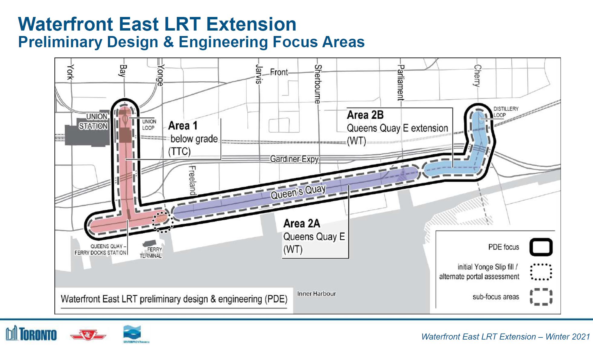
The study covers three segments of the line:
- Area 1: The existing Bay Street tunnel and the future junction at Bay & Queens Quay.
- Area 2A: The original scope of the surface section extending to just east of Parliament Street.
- Area 2B: The extended surface section from east of Parliament and north to Distillery Loop on Cherry Street.
Note that in the map below, the alignment of Cherry Street is the “new” street that will be built as part of new Port Lands across what will become Villiers Island. The new street jogs west south of the Gardiner Expressway rather than east.
Because expertise in underground construction lies with the TTC, they are designing Area 1. Waterfront Toronto is responsible for Area 2.
The study is also looking at staging options that could extend the scope south and east into the Port Lands.
Area 1: Union to Queens Quay
The existing Bay Street tunnel runs from a loop at Union south to Queens Quay and then turns west to a portal to street level. The line dates from 1990 and suffers from design decisions that constrained growth in demand including a small connecting passage and platform area at Union, and small exits at Queens Quay with no direct connection to adjacent buildings.

Variations on the new design have existed for many years, although initially these focussed on expanded capacity at Union. More recently, the need to expand Queens Quay Station became evident. The diagram below shows the expanded stations and the new East Portal to Queens Quay.
Many of the buildings here did not exist in 1990 when parking lots covered much of this area. The building on the northeast corner of Bay and Lake Shore is quite recent, and it includes the new GO Bus Terminal that replaced the one south of the Customs House building on Front east of Bay.

Growth will continue as shown below. These buildings do not all contribute to demand on the LRT line because they are in walking distance of Union. A major problem, however, will remain at Queens Quay with less-than-ideal connections from the station to existing and future buildings compounded by the seasonal volumes of traffic bound for the ferry docks.

The existing loop at Union has always been too small both because of physical constraints and because designers did not take into account the dynamics of passenger demand under various conditions.
- The diameter of the loop is constrained by adjacent buildings. An early proposal for Union Station from advocates for the line would have used surface running via Bay, Front and York Streets with a station directly above the mezzanine of the subway station. This was opposed by City road planners who still dreamed of the Front Street connection to the Gardiner Expressway and saw Front as an express route across downtown. Expressway plans are very hard to kill.
- The available space on the platform for waiting passengers was limited by swingout of the CLRV streetcars, a factor that was not included in calculations of platform capacity. This has improved with the use of Flexitys that do not protrude into platform as much as the CLRVs.
- There is strong bidirectional demand to and from the waterfront to housing and to recreational destinations. This was not taken into account in considering the capacity of the passage linking to the subway which is further limited by its doubling as queuing space for the platform.
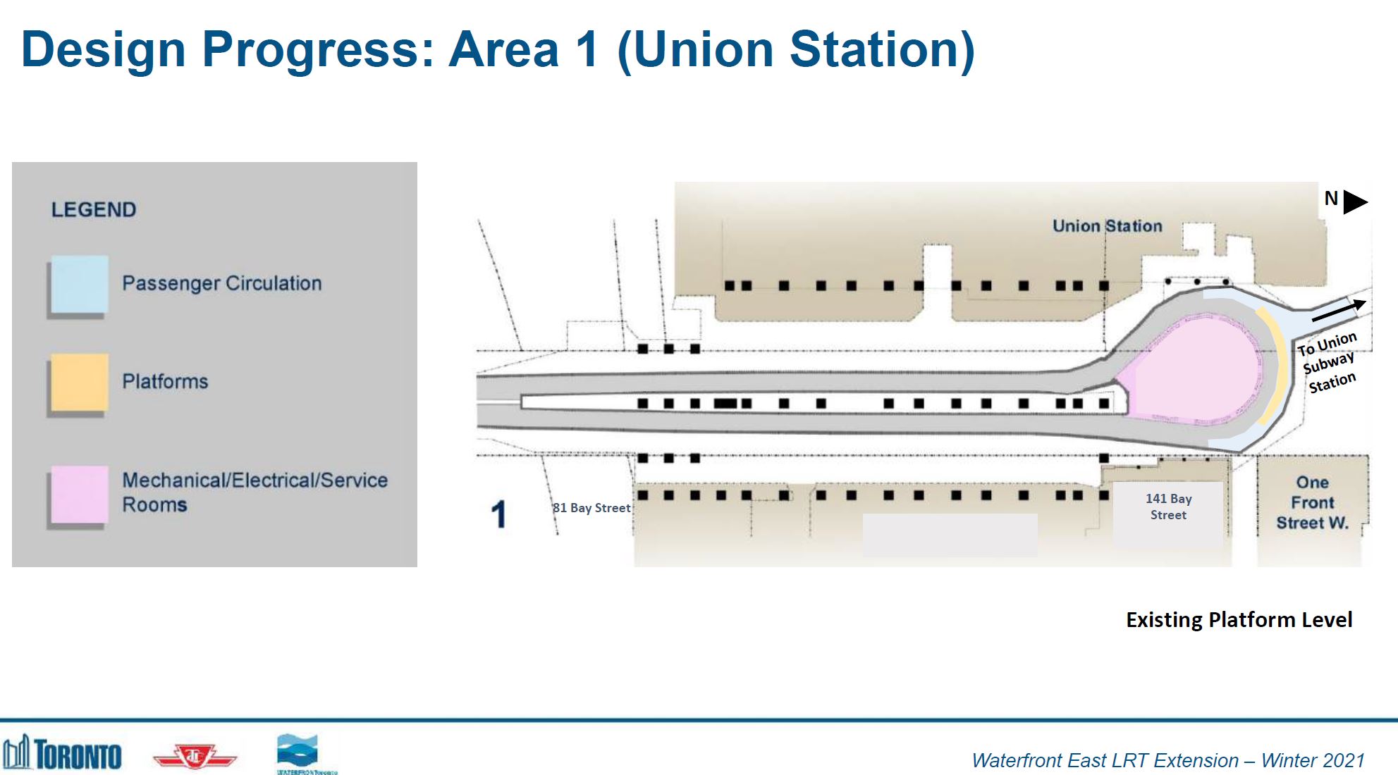
The proposed new station platforms would extend the entire length of the rail viaduct on both the northbound and southbound side of the tracks with unloading northbound and loading southbound. Each direction would be double-tracked with crossovers allowing cars on the Queens Quay west and east services to arrive, unload, load and depart independently of each other. A constraint remains at the loop, but this is no longer used for loading passengers, only for circulation.
In the diagram, note that the inner tracks, closest to the support columns, are the existing tracks, and the outer tracks and platforms would lie behind what is now the tunnel wall.
New links would be added into the as-yet unopened Bay Concourse of the railway station and emergency exits have been added to meet present-day fire code.
Also shown here is a junction with a Bremner streetcar line that would operate through the basement of the Scotiabank Arena and turn south on Simcoe to Bremner. This has been on maps for decades, but is unlikely to ever be built. Nonetheless it survives because it has never officially removed from official plans. (Note that there are physical conflicts between some of the tracks shown and the columns holding up the rail viaduct.)
A complication not addressed in this drawing is whether the new platforms will be in the “paid” or “unpaid” area. If “paid”, then any entrance must include fare barriers. Important, but missing from these design proposals, are the details of the entrances and how they relate to adjacent buildings.
Also not shown here are fire code related changes to track elevation to improve air circulation in the station. It is not clear whether this requirement has been dropped or if there is a design workaround. See update below for additional information about smoke control and other design features.

The text below has been replaced with information received after the article was published.
The new station would have much wider platforms and space for circulation as well as for waiting passengers. The drawings below contain some oddities, and I have asked the project team for clarification:
There is a glass wall limiting access to the loading area on the west platform. This is not a place where one would want a pinch point. Moreover, the wall is not shown in the upper left illustration of the platform.There is a similar wall on the east platform, but it lies between the two sets of tracks (including across the crossover).Earlier versions of this station design included grade changes required to lower the tracks and improve air circulation space to meet modern fire code. This is not shown on these diagrams.
Update from the Waterfront Transit Team:
The aerial rendering on page 52 is misleading. There are no “glass walls” proposed. These are glass smoke control screens proposed to be hung from the ceiling above edge of each platforms to act as smoke canopies to create a smoke “reservoir” above track level to contain smoke during emergencies in the event of smoke/fire from track level.
To resolve the complex problems of both fire and smoke separation from the many adjoining buildings as well as passenger safety and convenience, one single, large vestibule is proposed that extends from the North end of the East platform to the North end of the West platform. This vestibule is created through fire-rated glazed partitions around the perimeter of the track tunnel loop, with door thresholds provided at all access points. The doors will be on hold open and tied to the fire alarm system. This allows for continuity of the passenger circulation around the length of the loop rather than interrupted or constricted movement from small vestibules on the pathways that will inhibit passenger flow and result in bottle necks at each building entrance and exit locations.
The proposed track profiles and tunnel infrastructure at Union Station has been lowered by approximately 1.4m compared to the existing track elevations to accommodate structural, utility and civil requirements as well as alignment with the adjacent 141 Bay St underground structures. All proposed gradient through-out the platforms and passenger circulation route will meet AODA requirements for accessibility. Where possible, gradient along the pathways will be minimized (i.e. by lengthening the sloped floors to further reduce the slope) and improve access for customers.
Email from Waterfront Transit Team, February 16, 2021

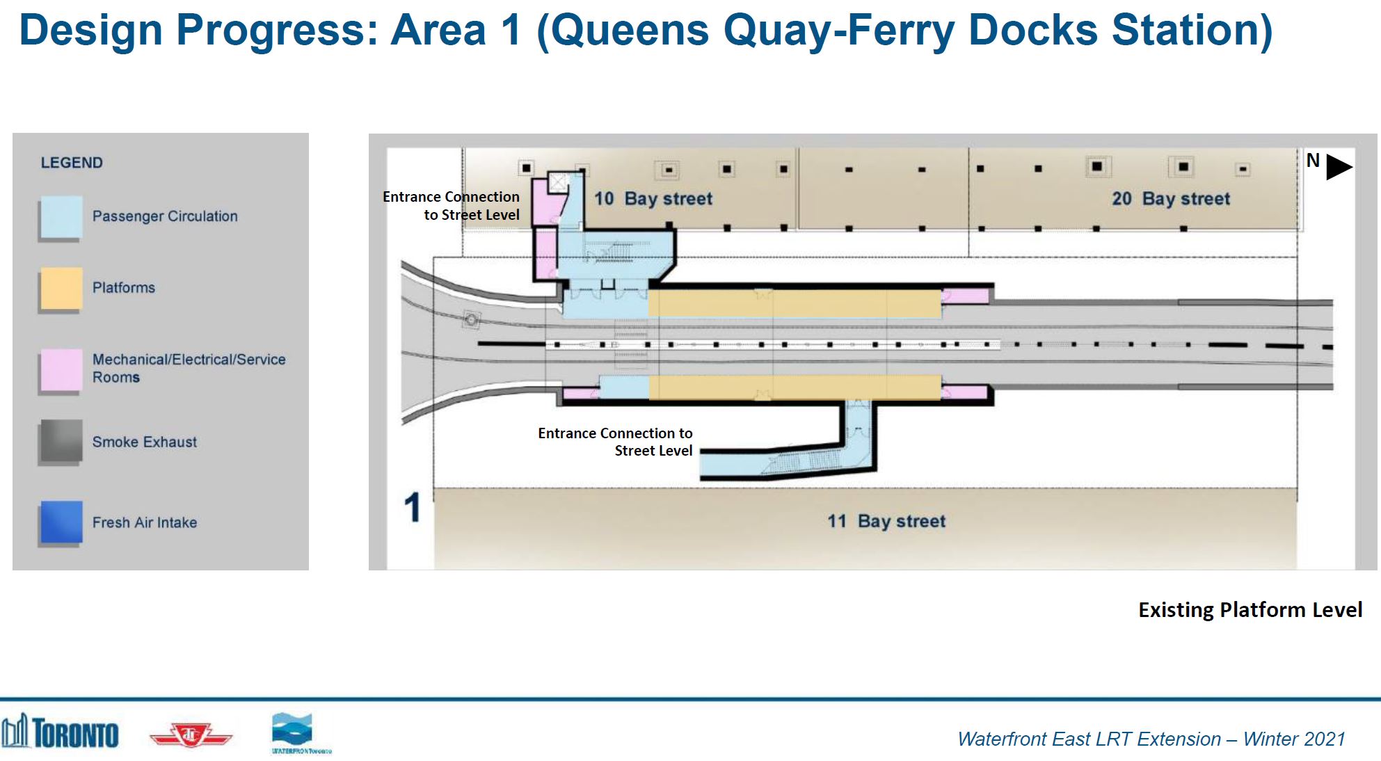
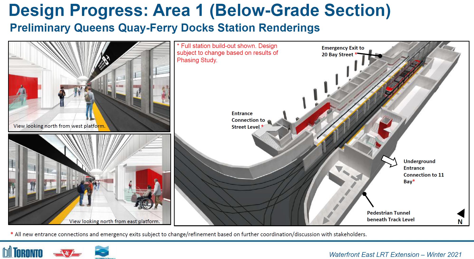
Queens Quay Station is small with room for only one car on the platform at a time. This would be a particular problem for inbound service that would back up into the new junction south of the station.
The capacity of links to the street is limited consisting of stair and (sometimes working) elevator on the west side, and a stair on the east side. This station is not a paid area.
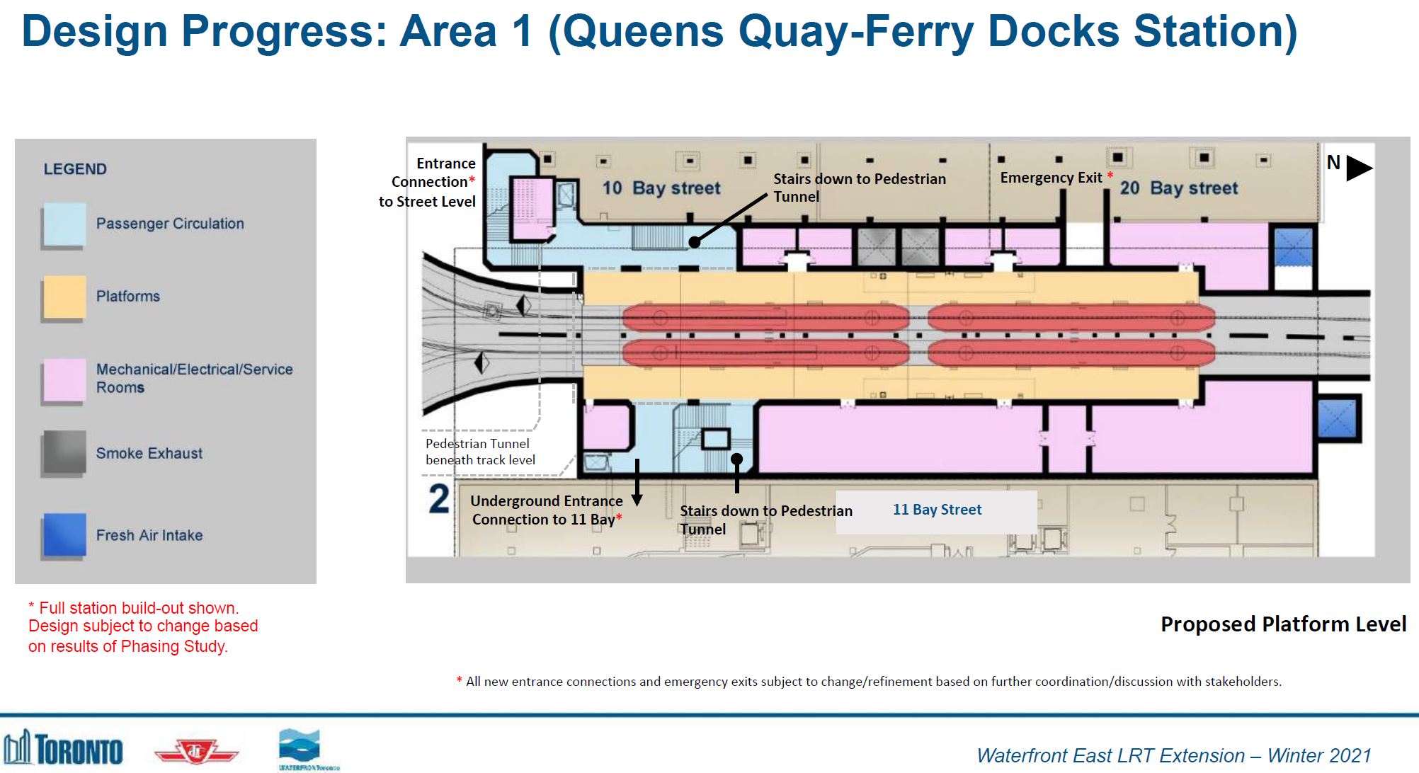
The expanded Queens Quay Station will be able to hold two cars in each direction. A major change here is the addition of a tunnel crossing to the south side of Queens Quay for access to the Ferry Docks. Access to the tunnel is via stairs and elevators from each platform.
Due to the constrained space, there are no escalators. It is conceivable that these would be available from the east platform within 11 Bay Street, but nothing is shown for the west side into 10 or 20 Bay (which share a common lobby) other than a new emergency exit. At the very least, any design work should address how an improve connection including escalators might be added at least to ensure that this is not precluded in a first phase of construction.
The existing pedestrian crossing at the south end of the station will be removed. It is needed today because the only accessible access to the station is via the elevator on the west side.
Portal Designs
In a previous iteration of planning, the new eastern portal would have been between Yonge and Freeland Streets, one block further east. This arrangement was required because the entrance roadway to the Harbour Castle Hotel on the south side of Queens Quay would be blocked by a portal west of Yonge.

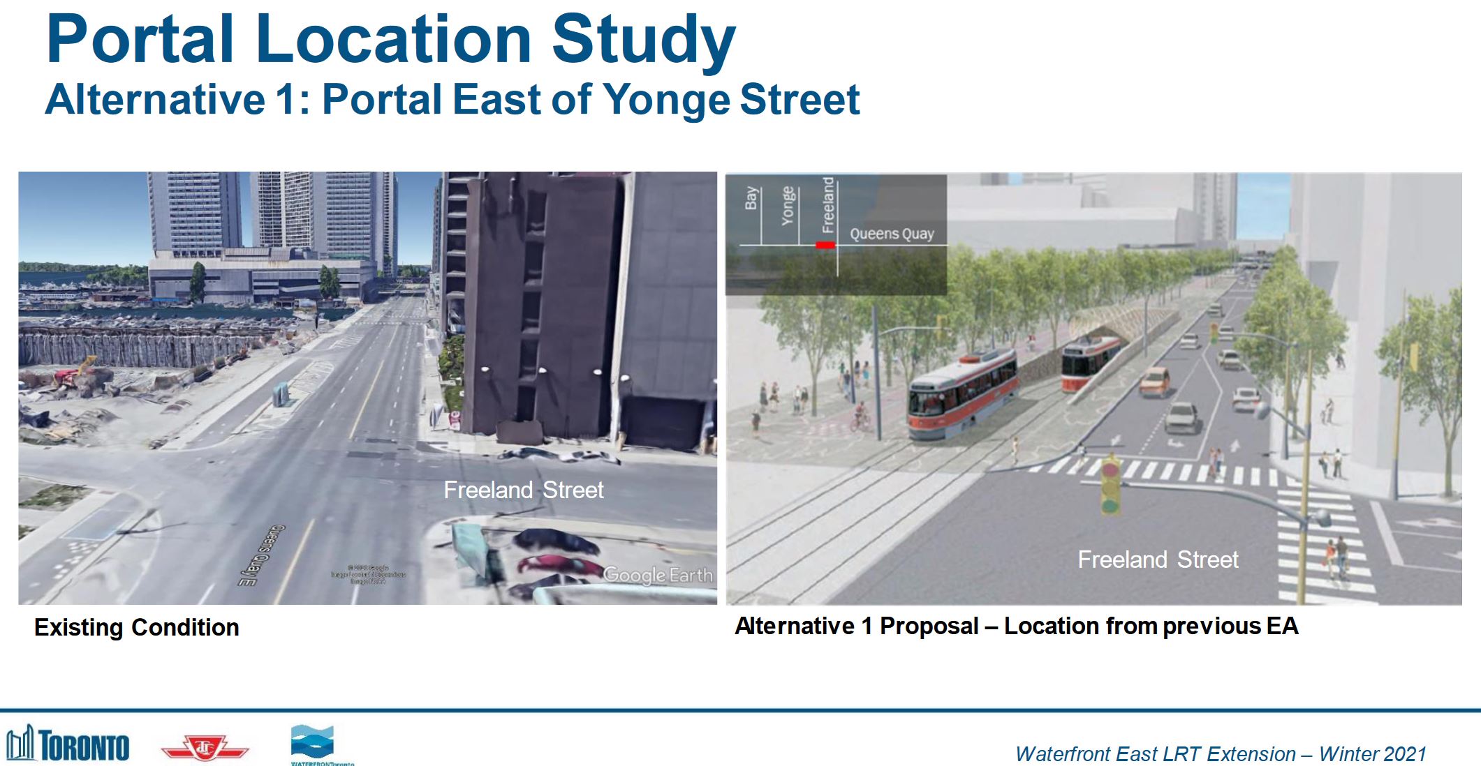
However, placing the portal east of Yonge requires that a major sewer crossing Queens Quay be relocated (or alternatively that the tunnel dodge under it) and this would add substantially to the cost.
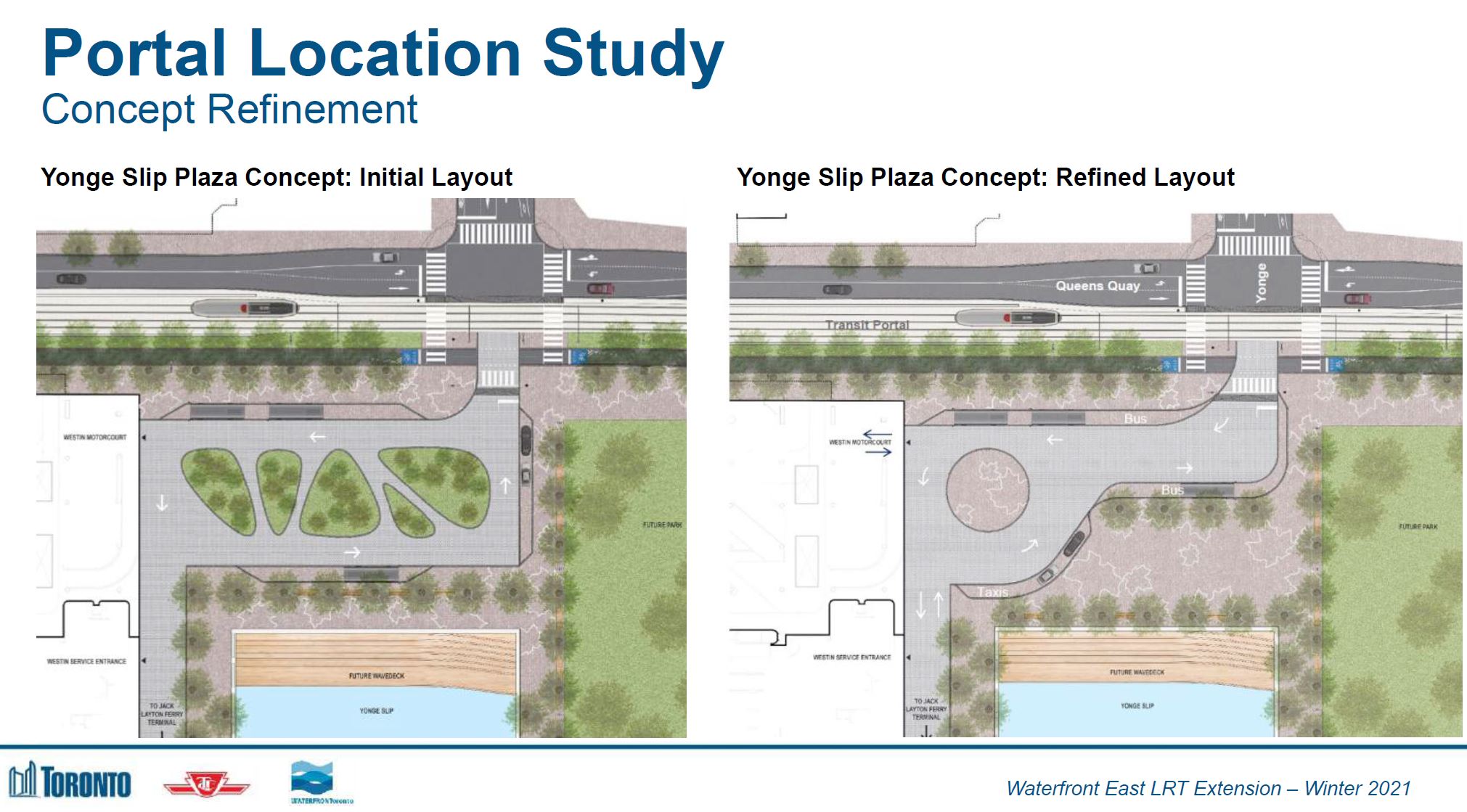
A revised scheme puts the portal west of Yonge in front of the hotel, but reorients its entrance to the east side of the building on existing parking and a partial filling of the Yonge Street slip. This design has been refined to improve circulation space for vehicles and shift the greenery to the pedestrian areas.
Here is the front of the hotel as it appears today.

The view below looks southwest across Yonge and Queens Quay. Note that the layout of the hotel entrance area is based on the original design (left, above), not the revised one.
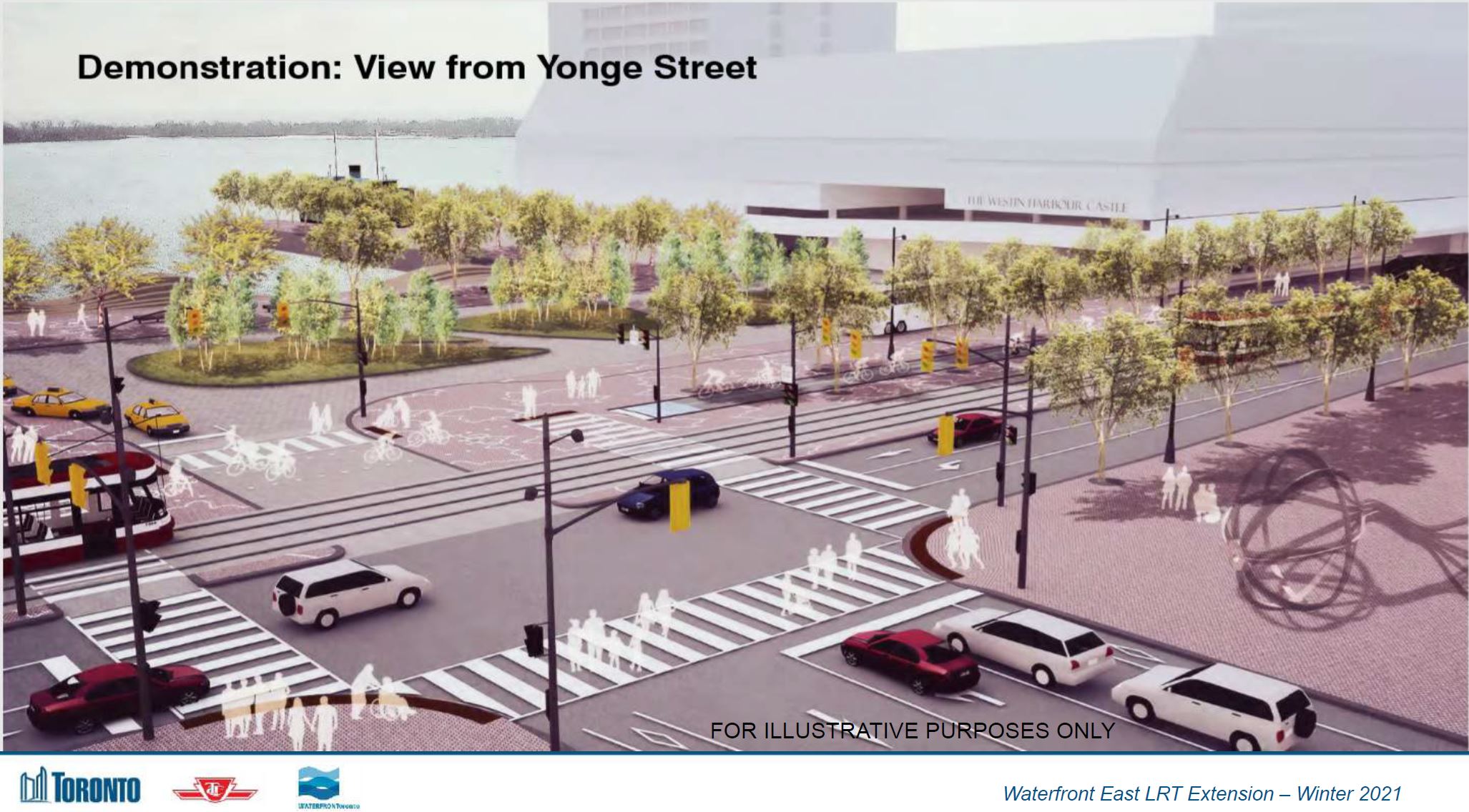
Update: Here is the same area in a view shown during the February 17 online consultation. Note that this includes some of the marine uses like water taxis that were missing in the drawing above.

Here is the view today showing the Yonge Street slip.

Network Phasing
Important issues during the development of this plan were the transit service required during construction, and the extent of the buildout of the proposed eastern waterfront network that would be undertaken in this round of construction.
The Bay Street tunnel will be closed for a few years due to the scale of changes at Union and Queens Quay stations. During this period, alternative service to the waterfront must be maintained. This is a very different situation from the era when the original line was built and the transit connection consisted only of the 6 Bay and 77 Spadina bus routes.
In an early version of this plan, the first phase of the Waterfront East line would have ended at a temporary loop at Small Street, just west of Parliament on the triangle of land formerly used as the Sidewalk Labs office. While simpler and cheaper, this limits other options:
- The streetcar line would be a stub serving only the area west of Parliament and it would provide no connection to the developing area to the east nor to the Distillery District.
- The planned reconfiguration of Queens Quay east of Parliament might be delayed because it was not part of “phase one”.
- There could be a sense that transit to the eastern waterfront was not a priority, even though this was intended to be a “transit first” neighbourhood.
Note that the map below shows the waterfront as it will exist after completion of the new Don River alignment and the creation of Villiers Island between the Keating Channel (the current outflow of the Don into Lake Ontario) and the new river.
Three additional segments of the waterfront network are included in the phasing study:
- Extending east from Parliament on a realigned Queens Quay to New Cherry Street and then north to Distillery Loop. This would bring service to planned developments and would allow through service between Queens Quay, Cherry and King Street.
- Extending south via New Cherry Street to a planned loop at Polson Street. The recently installed bridge at New Cherry over the Keating Channel (south of Lake Shore) is actually the transit bridge to Villiers Island. (The streetcar line will not cross the Ship Channel south of Polson Street.)
- Extending east from New Cherry via Commissioners Street and then north via the planned Broadview extension to East Harbour and beyond to Queen Street.
Realistically, I do not expect to see the extension across the Keating Channel for many years, and buses will continue to serve this area.
The Ontario Line comes up from time to time in discussions about waterfront transit. It is important to remember that the nearest station west of the Don will be Corktown Station near King and Parliament. That is not exactly handy to the neighbourhood, and East Harbour is even further afield.

An important part of the phasing will be to complete as much construction as possible before actually closing the Bay Street tunnel. This will allow any alternative service to operate on streets that are not themselves torn apart for the new line. In the first optional configuration:
- The 510 Spadina car is rerouted west to Exhibition Loop replacing the 509 Harbourfront car during most periods.
- A 509 Harbourfront tripper is routed north on Spadina and east on King to Church during peak periods and for special events (e.g. CNE service). This is a variation on the former 521 King Exhibition sevice.
- Three bus routes would link the waterfront to Union Station:
- The 6 Bay bus is routed via Front and Yonge to Queens Quay.
- A 509 bus would operate from Queens Quay Loop (at Spadina) to Union Station via Yonge Street.
- A 519 bus would operate from the eastern waterfront over the (by then) completed streetcar right-of-way to Yonge Street.

A second option would see through streetcar service on Queens Quay. This requires that the new portal and connection east from Bay Street be completed as soon as possible after the Bay Street tunnel closes. Indeed work could begin at the Yonge Street portal and work west breaking into the existing structure when service in the tunnel is suspended. This would also require the reorientation of the hotel entrance to occur early in the process so that the portal could be built.
Rather than thinking of these as options, it would be better to consider them as stages. There will be an inevitable period when through service will not be possible, but this could be minimized by staging each portion of the project.

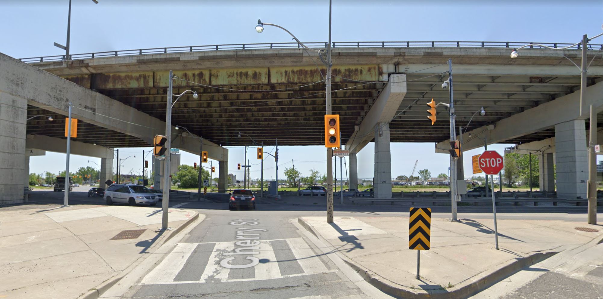
Cherry Street
Cherry Street will be realigned south of Lake Shore. Here is the view looking south from Cherry today. This is an inhospitable intersection, even for motorists. Coming south on Cherry, one must cross under the Gardiner, join with Lake Shore eastbound, and then turn south on the existing Cherry Street to enter the Port Lands.
The New Cherry Street will cross Lake Shore and then veer slightly west (to the right) to meet the extended Queens Quay.
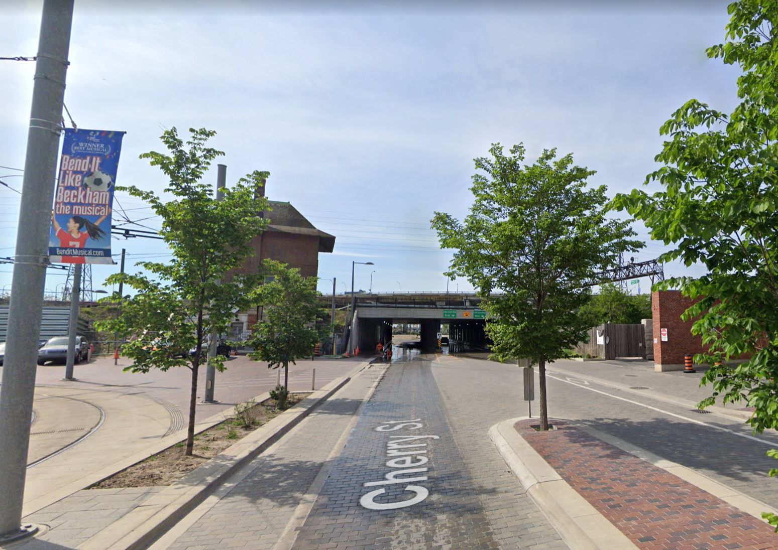
Cherry Street passes under the rail corridor immediately south of Distillery Loop. The existing, but inactive, Cherry Street signal tower will be moved to a location further east by Metrolinx for preservation. The design for an expanded (or twinned) underpass for streetcars has not yet been finalized. The streetcar lanes will be on the east side of New Cherry continuing the design north of Distillery Loop, and this will continue onto Villiers Island. The recently installed bridge is actually the transit bridge for New Cherry Street, and it will get a wider twin later in 2021 for the roadway.
Queens Quay East
The alignment of Queens Quay will change at Parliament Street. Today Queens Quay swings north to Lake Shore and connects to the south end of Parliament.
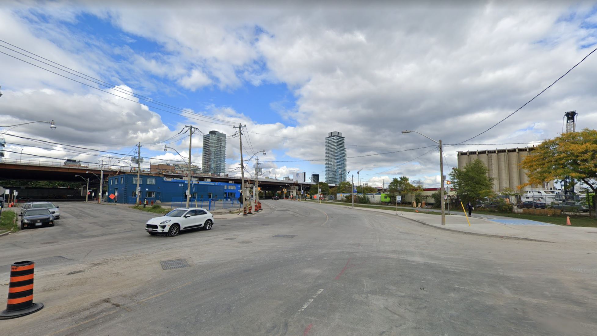
In the new design, the Parliament Slip will be partly filled, Queens Quay would be extended eastward running just north of the silos on the east side of the slip. Parliament would extend south eliminating the dog leg at Lake Shore. The eventual eastern end of Queens Quay would be at Munition Street, but the streetcar lanes would extend only to New Cherry (see the Network Phasing map above).

Here is the view looking south from Lake Shore east of Parliament showing the silos and the Parliament Slip.

In the original 2012 study of Queens Quay, the design was based on the western section of the street that is already reconfigued. The revised design implements a more distinct zone between the pedestrian and cycling areas and the road/transit portion of the street.
The Martin Goodman cycling trail has been widened, and its profile slightly changed to include a small grade change at its edge. The intent is to give more room for bicycles and better mark the boundary between the cycling and pedestrian areas.


At intersections, the original design was something of a free-for-all, a “mixing zone” where somehow each user of the street would figure out where they should be. There are still going to be overlaps which are hard to avoid, but with a better delineation of “who goes where”.
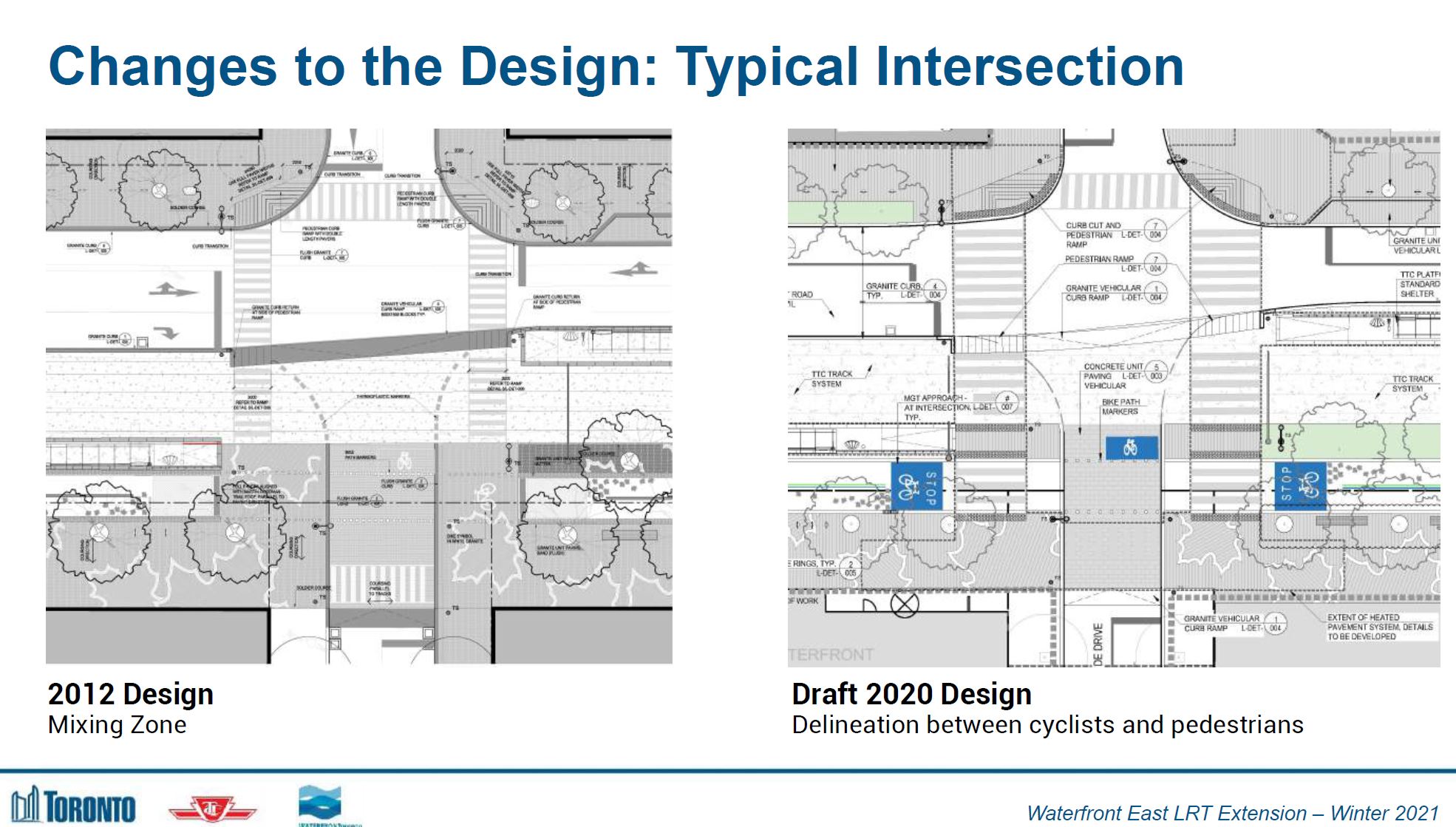
The design will use pavement treatments, trees and pole lines to give visual cues about each zone’s boundaries.

Funding and Construction
There is no funding in place yet for this project, although property owners in the eastern waterfront are becoming impatient waiting for the transit service they were promised as an enticement to build. Waterfront Toronto itself was distracted by Google and the Sidewalk Labs scheme, and design work on the Bay Street tunnel was needlessly delayed by consideration of impractical alternatives.
Will we actually see the line built within the next decade? Much depends on continue support from Mayor Tory who must wrest focus away from suburban subway plans enough to get approvals and funding for the line. The eastern waterfront can be transformed, but there has been far too much foot-dragging on what is a comparatively simple project.

This area is best served by buses and as such, I don’t see this project moving forward – ZERO chance.
Steve: Buses today, but with planned population and jobs in the area, tomorrow is another thing altogether.
LikeLiked by 1 person
Steve concludes:
Having had studio space on Berkeley (now Berkeley Castle), Eastern Ave (adjacent to the historical buildings Ford is trying to tear down) and on Polson in decades past, and the area being pleasantly surrealistic in a Bohemian sort of way at that time, to look at plans and the present situation…I find it even more surreal, and not in a pleasant way.
I agree with Mike’s remarks as fitting, even if brutal, and even as ‘improvements’ are afoot on lower Cherry St. ostensibly for the Huckleberry Finn paradise disseminated by the Waterfront wet-dream.
As much as I’d like to buy-in to all the hype (and the Sidewalk Lab lame lurch was the height of surrealism), I just can’t accept that anything akin to what’s being touted will ever come to fruition in the style and manner presented.
Toronto Council, Waterfront Toronto, TTC , Province and Feds have all oversold dreams. And very little will be delivered, at least in the next few decades I’ll live if lucky.
Will the Don be redirected to avoid flooding? That I find believable. Perhaps once the West Don Lands becomes something inviting (and yes, I cycle through it often in the Summer) I’ll believe what’s being touted to the south and along the Waterfront.
Pardon my cynicism, but this is a City that talks a lot, and does little. I’m sure Mike and I aren’t the only ones not buying into ‘the dream’.
This is a city hell-bent on building the SSE and revamping the Gardiner at incredible cost. Landscape escapes them.
Steve: I don’t know if you’ve been watching the videos posted by Waterfront Toronto, but the new channel for the Don is coming along nicely. That whole Sidewalk Labs was a huge boondoggle that wasted at least three years and destroyed a lot of good will WFT had built up with many of us who had long supported their work and helped to bring the new waterfront to life. The utterly unlamented Will Fleissig was an appalling CEO who had no idea what public participation might bring him if only he let it, and Sidewalk Labs had so much faux-participation that it was sickening. They really didn’t know what they were doing. I think that the Waterfront Board has a llot to answer for on that count.
It’s odd that the Don River project just keeps beavering away in spite of screw-ups elsewhere and it will be amazing once it is completed. Part of me still fears that DoFo might try to screw it up, and the boffins at Metrolinx I’m sure would love to claim that the Ontario Line is all we will ever need even though its a long way from that neighbourhood.
LikeLike
Looks very positive, if it gets built!!
Has there been any talk about approximate timeframe? The only hint I’ve seen is it was all included on the proposed 2031 TTC Rapid Transit Map in the Transit Network Expansion report at the February TTC board meeting, including the service on Broadview from Queen to Commissioners.
At one point there was discussion of extending the 65 Parliament service down to Queens Quay when development progressed. Any further talk of this?
Oops, in the presentation, they show the streetcar service on Broadview as existing, south of Queen to East Harbour GO.
Steve: The report in the recent Board meeting agenda about rapid transit expansion (to which I will turn in my next article) gives a date of “TBD – late 2020s”, and I suspect that this is optimistic given the financial constraints the city will face in coming years. The real impetus for this will be more announcements about developments the line would serve.
I am sure that there will be several changes to transit routes in the eastern waterfront once the waterfront LRT and the Ontario Line are in operation. A big unknown for the timing of demand is the rate of buildout of the residential and office developments planned there, especially at East Harbour.
LikeLike
Another great article, Steve!
I’m wondering when you will write a piece on the Eglinton East LRT Extension, since it is (mostly) funded now with SSE tax money. Tory and his executive committee recently recommended for the project to be approved and funded in the next budget.
Steve: There is nothing more to write about this line until more detailed design info is available. I am also not certain that it is a fully funded project yet. The estimated cost is over $4 billion.
Mayor Tory’s motion reads:
It is not clear where the federal contribution to the SSE will wind up, but the province has already called on them to help fund various projects in the GTHA. I doubt this money is available for the EELRT, and new subsidy would have come from one of the available programs if anything is left after the province soaks up money for its own projects.
LikeLike
Steve said, regarding the proposed Bremner streetcar:
Could it be possible for build a turnaround track south of the rail viaduct?
In that scenario Bremner East/Union Station-bound streetcars would turn right (south) then loop around the columns and head north toward the Union Station platforms. But long before a Bremner streetcar would be built, this turnaround track could help streetcars turn around and head back north to Union Station (for example, in emergencies, or to head in/out of service, or if being reassigned from QQE service to QQW service).
Steve: No. The buildings on either side of Bay south of the rail viaduct are at least as close together as those that constrain the loop at Union. As for changing the assigned destination of cars, the track arrangement at Union allows cars to board at either of two platforms (similar to the arrangement at Exhibition Loop). There is no need to loop around south of the loop.
Regarding the persistence of the Bremner streetcar itself, is there also a desire among TTC staff to have it so they can move streetcars in and out of the Queen’s Quay service without having to run along downtown track?
Steve: No. It’s just that it has always been there on the plans. There are locations along the proposed route where it was a challenging fit and now is impossible. It should have been stripped out of City plans years ago.
Finally on the phased construction of the Bay Street tunnel…it will certainly be disappointing that the connection to Union Station will be temporarily shut down again. It doesn’t look as if they are interested in phasing construction to build the Cherry extension and QQE track first so that streetcars would be able to operate east-west along Queen’s Quay,
albeit temporarily.
Of course this might require some creative approaches to laying track, but again, temporarily.
Steve: Actually there has been a fair amount of discussion about this in the advisory committee meetings.
Steve concludes:
Twas ever thus.
Cheers, Moaz
LikeLike
Thank you for the overview of the Waterfront East plans. I’m surprised by how much attention this part of the Waterfront has received, while upgrading the Western portion, with lots of residents and existing usage potential seems to be nowhere to be seen. Why is that?
Steve: I am not sure what you mean by “upgrading”, although there are various works planned when money is available including:
LikeLike
I noticed a full ‘T” intersection at Bay and Queens Quay. Is the East-West route intended for non-revenue movements only? If service might go East-West, it misses the station. Oversight?
Steve: There is a possibility that there could be an east-west service on top of those that go to Union. The through track will be needed if service is maintained to a pre-built eastern leg while the Bay Street tunnel and stations are rebuilt. Otherwise it would certainly be handy to divert around problems in the tunnel itself including periods when it is closed for repairs.
LikeLike
Thank you for the great overview. Glad you have been participating in the advisory committee and looking forward to tonight’s meeting.
Are you able to elaborate on the following from a comment above? Where are the challenging fits vs the impossible areas? Is there a more detailed plan available somewhere?
Steve: Probably the most difficult part was the East Portal, and the shift to west of Yonge Street with the associated reorientation of the hotel entrance unlocked things. The alignment to miss the sewer under Yonge was not pretty and would have been complicated by the high water table. When you can see the water level 20 feet away, this tends to focus the mind on staying close to the surface.
The Cherry Street connection requires more space under the rail corridor than already exists. Various options are being considered about how this will be handled.
There is no detailed plan for the entire line because design options have been evolving. The next round of work will take the proposed layout to 30% and at that point the project has to be funded for construction. One good point on this is that Mayor Tory supports the project because it underpins redevelopment of the eastern harbour.
——-
Regarding the persistence of the Bremner streetcar itself, is there also a desire among TTC staff to have it so they can move streetcars in and out of the Queen’s Quay service without having to run along downtown track?
—–
Thank you.
LikeLike
Thanks for your detailed overview, Steve.
I wonder if turning the existing tunnel under Bay St into a wide underground pedestrian way with faster moving horizontal escalators connecting Union Station with Queen’s Quay Terminal Station, might save complicated construction time and cost, accommodate crowd fluctuations, avoid streetcar interlining bottlenecks and allow the Waterfront line to be one continuous line? The horizontal escalator has been used in the sprawling Universal Studios Florida theme park for years.
Steve: Something like this was one of the proposed alternatives. There are several problems. There isn’t enough room for both a moving sidewalk and an alternate path for use when the sidewalk is out of service for repairs. Also, the tunnel is not level. It’s a long walk to/from Queens Quay if the sidewalk is not moving for the thousands of people projected to use the east and west services in the peak hour, and they would all be forced to board/alight from an east-west service at QQ. This would make the “onerous” transfer between the subway and the RT at Kennedy Station look positively simple and convenient by comparison.
It is also bloody cold and damp in that tunnel. Imagine all those happy commuters tracking snow and salt onto the sidewalk.
This is not a workable proposal.
LikeLike
Steve thanks for another excellent article outlining the status of the Eastern Waterfront LRT.
Is there any possibility of temporary track up York Street? This could offer a one way loop close to Union. Or once the “T” at Bay is in, run across Queens Quay and up Parliament to King.
As the construction of the Broadview streetcar line is well off in the future, was any consideration given to running across Commissioners St. to Leslie St and the Barns? While it would make a very long and awkward “loop” it does offer a second exit for the Barns.
Steve: Going up York is possible in theory, but a lot of work for a temporary connection. Also there are flooding problems in the York Street underpass, as well as planned construction between Front and Wellington for extension of the PATH network. Better to focus on getting through service across Bay and Queens Quay as quickly as possible.
The link to Leslie Barns via Commissioners has always been part of the plan, just not in this phase. The Broadview portion is only included because it looked as if East Harbour’s development would happen in the same timeframe as the waterfront east construction. If this does go ahead, I would not be surprised to see the link via Commissioners added on to the project as an important part – the LRT bridge over the Don River on Commissioners – would have to be installed to get to Broadview.
LikeLike
How does being an “insider” and being part of an advisory committee shaping a project compare to being an “outsider” with no special access and reviewing or critiquing a project.
Do you personally enjoy one over the other?
Steve: A lot of this depends on the receptiveness of the agency involved to public participation. City Planning and Waterfront Toronto have a long history of this, and they welcome input. The TTC does so less publicly, and a lot depends on who is in charge from decade to decade. I was involved in the King Street study both as a consultant (travel time analysis) and as a SAC member. I have been involved with WFT for a very long time on their transit projects again primarily as a SAC member (one of many who represented a wide variety of backgrounds).
My long history of advocacy and the blog, plus the willingness to trade my pseudo-media hat for a role in early planning, grants me credibility I would not have if my paying job were as a journalist looking for a story. I have often not published info here that I know from the advance meetings because it is (a) subject to change until it is announced and (b) could be the result of discussions among parties that should not be trotted out just so that I have a “story”. This is even the case when other SAC members have not observed the same propriety.
Metrolinx is another can of worms entirely. Their “participation” process is geared to getting their audience to endorse whatever they planned to do, not to solicit real input or (*gasp* alternatives). I and many others attended a workshop on fare collection years ago when Metrolinx was keen to push fare by distance, but on a zero sum basis that would penalize Toronto rider so that those crossing the 905-416 boundary could get a cheaper fare. Never mind better operating subsidies or improved service, just get rid of the fare boundary, and jack up the cost of subway travel to pay for it. Let’s say that the attendees, who represented a wide range of background, were not uniformly impressed. There was supposed to be another meeting to look at a refined proposal, but neither the proposal or that meeting ever saw the light of day.
I may be incredibly naive in giving away my input free of charge, but I also have no financial axe to grind, no paymaster to serve. I just want to help make the city a better place and especially its transit system. I cannot say the same of some “professionals” in the field, let alone their political patrons. In my criticism, I attempt to avoid ad-hominem arguments unless someone has the temerity to talk about “their” plan, or goes on a personal attack (which could masquerade as gaslighting) against me or other members of the public.
In “the old days”, I would show up regularly to make my five-minute pitch as a deputation at TTC and City meetings. I was ignored a lot, an experience those who have followed in my footsteps will recognize. The real influence came from being a technical source to the media, to community groups, to politicians and even (softly, softly) to staff who wanted to bounce ideas off of me.
I now have my very own soapbox here, and I know it’s read in low and high places.
LikeLike
Over a decade ago, I attended a TTC Board (then The Commission) meeting. Adam G was Chair and I was ‘horrified; how he took phone calls and actually left the room while deputants spoke; I lost all respect for him after that. Thanks to you Steve for persevering and continuing to try to educate us (and, I hope, ‘Commissioners’) on what we should look for and what the TTC management would prefer we did not notice!
LikeLike
Following up on Jim G’s suggestion and your reply, it’s the Lower Simcoe underpass that is notorious for flooding.
Steve: Yes, Simcoe Street. Thanks for the correction!
The York St. on-ramp to the Gardiner is also prone to flooding but is more of a concern for pedestrians where the water can be several inches deep while vehicles plow through. With the shortening of the eastbound offramp to York/Bay/Yonge traffic now backs up on the segment of York St. between Harbour and Lake Shore, throwing in a streetcar (which would be a tight squeeze) would probably make matters worse as it would reduce that segment’s capacity in half when facing a red light at Lake Shore. Good luck if there’s a delivery or taxi/ride share stopped in the right lane!
What I would rather see, though it doesn’t address the connection to Union but does create some redundancy, is additional trackage along Harbour St. from York St. to as far as its realligned terminus at Jarvis St. through the redeveloped LCBO lands connected to Queens Quay at either end. It would allow for streetcar service to continue through the neighbourhood if work (or another errant driver) shuts down the Bay St. tunnel. It would require a transfer to get to the subway either at Bay or Yonge and will likely complicate the traffic signals at York and Queens Quay to allow for turning streetcars which will hopefully spur an improvement.
Steve: Through east-west service will be possible on Queens Quay because there will be a full T junction at Bay Street. Indeed there is chance that the through service could begin operation while the Bay Street tunnel is under construction. As for errant motorists, they will no longer be forced into the Bay Street tunnel and could drive right through and out the east portal. A good analogy is the arrangement at St. Clair West Station.
The bike trail that replaced the Yonge St. off-ramp on Harbour St. is about the same width as the ROW on Queens Quay and the Westin Conference Centre is slated for redevelopment. A more sweeping curve through the yet-to-be redeveloped park where the circular off-ramp was should cut down on noise from turning streetcars. This could also be replicated with the proposed park between Cooper and Freeland providing some symmetry if Jarvis is problematic. Laying new track will probably be faster than reconfiguring and extending the portals at Queens Quay and Bay. Timing is key however before all of the redevelopments are locked into place.
LikeLike
Moaz: I’d be interested to hear more about this. Have there been any decisions? Is it leaning towards laying track on the surface between the two portals, or constructing the east portal first, then the track wye at Bay (requiring a short shutdown)?
Moaz: That would certainly make for an interesting tunnel design. How thick can engineers make transparent aluminum these days? 😉
Steve: The idea of running a through east-west service while the Bay Street tunnel was under construction came up at one of the SAC meetings last year. There had already been talk of doing parts of the project in parallel so that the Yonge to Cherry (originally Parliament) construction could proceed as soon as possible.
Then came the idea of prebuilding as much as possible right down to the location where the new eastern portal and ramp would connect into the existing tunnel, then breaking through the wall and establishing the east-west trackage while construction to the north started.
Partly, this idea came from an abandoned design and staging that would have used a people mover in the tunnel with streetcars only running east-west on Queens Quay. There would have to be a shutdown for a transitional period, but not for long.
LikeLike