
October 6, 2020: This article has been updated with information on the north section of the Ontario Line between Danforth and Eglinton (Pape to Science Centre).
September 29, 2020: This article has been updated with information on the east section of the Ontario Line between the Don River and Danforth.
September 23, 2020: This article has been updated with information on the central section of the Ontario Line between Osgoode Station and the west side of the Don River.
I asked Metrolinx a series of questions about information released in the two “neighbourhood updates”:
1. The station boxes that are shown are barely 100m long. What provision will the stations include for ventilation shafts? Will they be within the platform area or will they be beyond the end of the platforms as on, for example, the Crosstown line?
2. There is only minimal discussion of entrance locations. Will the stations include two separate paths from platform to surface as per fire code?
3. Will there be emergency service buildings between the more widely spaced stations to provide egress in case of a tunnel fire?
4. There is reference to using the space for lower Queen station as part of the design, but this area is (a) fairly small and (b) already used for a variety of purposes. Is the intent to have the OL go beneath all of the existing structure with the actual track and platform below lower Queen and with the “ghost” station space (which is already used in part as a pedestrian underpass between northbound and southbound platforms) only used for circulation space between the two lines? That would make a lot more sense than actually trying to take OL trains through the existing lower Queen Station.
5. The diagram of the Don Yard shows a direct conflict between the structure for the westbound OL portal and the Richmond Hill GO corridor. What is happening here?
In response, Metrolinx issued the following rather opaque reply:
Metrolinx will factor in all necessary safety and accessibility requirements into the Ontario Line designs. The most recent update is a more detailed vision of the project, but more details are still to come.
Metrolinx will be closely coordinating any Ontario Line work alongside our existing rail operations to minimize or avoid service impacts, while also respecting concurrent GO Expansion work.
Email from Scott Money, Metrolinx Media Relations
The original article begins here:
On September 17, 2020, Metrolinx released the Draft Environmental Conditions Report [Draft ECR] for the Ontario Line.
A huge volume of material is included, thousands of pages, but the vast majority of this only documents existing conditions and gives little indication of the actual “environmental impact” that building and operating the Ontario Line will have.
For convenience, here are links to source materials. The Draft ECR link leads to a page with many documents, some of which are very large PDFs.
- Ontario Line “Get Engaged” Page
- Ontario Line “Environment” Page
- Ontario Line “Procurement” Page
- Neighbourhood Update West
- Draft Environmental Conditions Report
- Metrolinx Blog: Zooming in on Ontario Line plans from Exhibition to Spadina
- Metrolinx Blog: Updated Ontario Line plans from the Don River to Gerrard: Maximizing space within the existing GO rail corridor
- Metrolinx Update to City of Toronto, September 2020
- The Ontario Line – Neighbourhood Updates – Downtown
- The Ontario Line – Neighbourhood Updates – East
- [New] The Ontario Line – Neighbourhood Updates – North
Jump to section-specific discussions:
- Exhibition to Queen/Spadina
- Osgoode to Don River
- Don River to Danforth
- Danforth to Eglinton
- General Issues
It is self-evident that the actual impact of any project cannot be known without the details of what will be built. This information is not yet public and only sample area maps which are drafts “for illustrative purposes only” have been released for a portion of the route. More will follow in coming weeks, but one must ask why they are not all available now if Metrolinx expects informed comment on their proposal.
Even on the supplied maps, many key features are missing including:
- Vertical and horizontal alignment including property requirements for construction
- Station sites, access and circulation plans including redundant paths between platforms and the surface for fire safety
- Emergency service buildings and access structures to tunnels
- Utility buildings such as substations
During the public consultation process and as recently as the April 2020 report summarizing this work, the project timeline was illustrated as below. This clearly shows that only one set of “Environmental Reports” were to be published and this was expected in Fall 2020, that is to say, now.
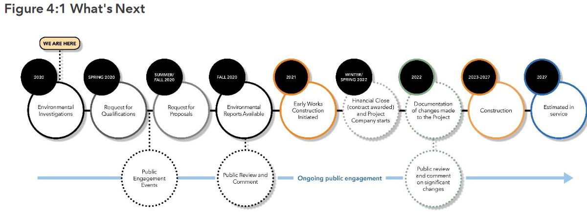
Ontario changed the legislation relating to Environmental Assessments with the effect that the item of most interest — the actual design and effect of the project — will not be known until later in the process than the public originally expected.
As required under O. Reg. 341/20, Metrolinx is preparing an environmental conditions report, which will be published for public review and input prior to finalization. The report will characterize the environmental setting in the vicinity of the Ontario Line, including existing noise and vibration levels, air quality, natural environment features, built heritage and archaeological resources, socio-economic and land use features, and traffic conditions.
Metrolinx is also planning to publish early works reports for components of the Ontario Line project that are planned to proceed to implementation ahead of completion of the Ontario Line assessment process.The early works reports will assess the environmental impacts of the early works and describe associated mitigation measures. The early works reports will be published for public review and input prior to finalization.
Following finalization of early works reports, Metrolinx will publish an environmental impact assessment report, which will assess the environmental impacts of the Ontario Line and describe associated mitigation measures. The environmental impact assessment report will be published for public review and input prior to finalization,as part of Metrolinx’s effort to meet the best practices and community consultation principles that are part of the Environmental Assessment Act with all projects. This will be followed by early works reports and the Environmental Impact Assessment Report environmental impact evaluation results, mitigation measures, monitoring activities, potentially required permits and approvals and other components.
Source: Metrolinx Update to City of Toronto, p. 13
There are now three streams of reports and consultation. First up is the ECR which has just been issued, but separately there are reports on “Early Works” (design and construction that can get underway to advance the project before the full design is locked down) and then the “Environmental Impact Assessment Report”. It is only in the last report that the details of design and effects on neighbourhoods will be revealed, and this is planned for winter-spring 2021.

On a parallel track, the procurement process is already underway with teams short-listed to bid on two major contracts:
- Rolling Stock, Systems, Operations and Maintenance (RSSOM)
- Southern Civil, Stations and Tunnel (Exhibition to Don Yard Portal)
The Northern Civil, Stations and Tunnel package (Don Yard Portal to Eglinton) will be tendered separately in 2022.
The ECR contains material reviewing conditions in a wide study area shown in the map below.
The study area is relatively wide in some areas, but narrower in others implying that a range of options was reviewed for parts of the route. Notable by its absence is the original Eastern-Pape corridor for the Relief Line showing that there was never any intention of entertaining this as an option, if only for comparative purposes.
The study area in Thorncliffe/Flemingdon is fairly large in part because this includes the proposed maintenance yard, but also because alternative routes through this area were under consideration.

Alignment plans are shown only for the western segment between Exhibition and Queen/Spadina at this point. Metrolinx plans to unveil details of additional segments on a weekly basis for other parts of the line:
- Osgoode Station to Don Yard
- East Harbour to Pape South
- Pape North to Science Centre (Eglinton)
They have published details for the first segment in a blog article as well as on the West Neighbourhood page (both linked above). I will update this article as information on these segments is revealed.
One burning issue in the third segment is the alignment through and effects on the South Riverdale and Leslieville area between East Harbour and Gerrard Stations. Although details on this have not been published, there is a note in a recent Metrolinx report to City Council (linked above) about the area just north of Queen Street where a recreation centre stood in the line’s path.
The Ontario Line team is working with City staff to ensure the project is delivered with minimal impacts to sensitive community areas and properties, such as parks and community centres. For example, following significant design and engineering effort, the station at Riverside/Leslieville has been positioned to avoid impacting Jimmie Simpson Community Centre. Efforts are underway to minimize impacts to other key community assets, including, Pape Avenue Middle School, Valley Park Middle School, Bruce Mackey Park, the future Ordnance Park, places of worship and other locations. Where an impact cannot be avoided the team will continue to work with City staff to address continuity of programming.
Source: Metrolinx Update to City of Toronto, p. 13
Exhibition to Queen/Spadina
The route between Exhibition Station and Queen/Spadina has been changed quite significantly since the original Ontario Line proposal. What was once a route with two sharp curves is now a diagonal stretching from north of Fort York to just west of Spadina.
The intent is to tunnel mainly in bedrock in order to be under all existing structures and utilities. Given the geology of downtown Toronto, this is no surprise, but it is intriguing in that plans for the Relief Line explicitly avoided a bedrock tunnel because of its depth. In turn that produced constraints on possible alignments because of the congested territory between bedrock and the surface.
Deep tunneling will avoid the upheavals of cut-and-cover construction that has been seen on Eglinton, although this would also require a station design placing the majority of the structure inside the tunnel rather than needing a full excavation for the station boxes as on Eglinton. Details of the station design beyond general placement of the platforms have not been released.
With a deep tunnel, Metrolinx claims that they hope not to disrupt surface transit, notably the heavily-used streetcar lines, although they are vague on the details.
Current plans envision maintaining streetcar service in these areas throughout the duration of the project, though there might be times when service is re-routed or reduced to accommodate construction work.

The alignment at Exhibition Station has changed from earlier diagrams with the platform and guideway north of the rail corridor rather than astride it. This arrangement eliminates a potential “across the platform” transfer arrangement between Ontario Line and GO trains that would aid in separating demand into the core into two streams with GO passengers heading to Union and OL passengers heading north and east via Queen.
Numbers on the plan below refer to (1) the tail track area west of the station to Dufferin Street and (2) the GO station.
Separate projects now in the design stage include the proposed extension of the streetcar right-of-way west from Exhibition Loop to Dufferin Street as well as modifications of the GO station area to improve linkage between transit services here.
The northern station location places it in walking distance of the southern part of Liberty Village, but the attractiveness fades the further north one goes and, of course, depending on the quality of service provided on 504 King and 501 Queen as well as the proposed GO/SmartTrack station on the Weston rail corridor north of King.
This station is of little use to residents of the condo towers east of Exhibition Place who will continue to use the streetcar service to reach downtown.

East of Exhibition Station, the line drops to grade to pass under the bridge at Strachan Avenue (1) and then into a tunnel. The launch site for the tunnel boring machine will be east of Strachan Avenue (2) on a site that will eventually be Ordnance Park.
The Garrison Bridge (3) over the rail corridor is to be preserved although Metrolinx says that it may be closed during part of the construction work.
While there may be times when it will be closed due to construction work, Metrolinx is studying ways to minimize impacts and maintain pedestrian and cycling access across the rail corridors for the duration of the project.

The station at Bathurst/King will lie diagonally across the two streets with the main entrance on the southeast corner. The Wheat Sheaf Tavern will remain in place. This would be an excellent name for a future station in a town that could not bear the idea of that den of iniquity, Yorkville, lending its name to what is now Bay Station.

On reaching Queen Street, the tunnel turns straight east under Queen and will follow it across downtown. It is not yet clear where the entrance(s) to the station will be located.

Osgoode Station to the Don River
[Added September 23, 2020]
The alignment between Osgoode Station and the Don has been modified considerably from both the original Relief Line concept and the original diagram for the Ontario Line.
- Queen Station is no longer positioned between Yonge and Bay as a “City Hall” station was in the Relief Line, but is centred on Yonge Street.
- The proposed Relief Line station at Parliament has been shifted west and slightly north to be under Moss Park between Sherbourne and Jarvis where construction will be easier.
- A station serving Corktown has been shifted to the east side of Berkeley Street between King and Front. This is a modest change from the original Ontario Line, but a major change from the planned Relief Line station that would have been at King and Sumach Streets.
- The alignment in the rail corridor has been shifted so that the Ontario Line straddles the outermost GO Transit tracks for an across-the-platform transfer at East Harbour Station.

Osgoode Station will lie between the east side of University Avenue and Simcoe Street, a change from earlier designs when it was to be in the block between York and University.

Queen Station has been shifted east to lie directly under Yonge Street rather than further west to Bay as a “City Hall” station.
Metrolinx says that this station will “make use of an underground cavern below Queen Street, built during construction of the first section of the Yonge Street subway”. In fact, that cavern is not very long, and is already occupied by assorted machinery in the portion that is not already used as an underpass between the northbound and southbound platforms.
There is also the matter of the capacity of vertical access between this area and the station above given the amount of transfer traffic likely at this location.
I have asked Metrolinx for clarification of the vertical arrangement at Queen Station.

Moss Park Station has been shifted north of Queen into existing open space to simplify station construction. On the original Relief Line this station would have been further east. Metrolinx claims that this station will relieve pressure on streetcar service on Queen, but that is a bit of a stretch given that this is only one stop east of Yonge and there are more closely-spaced stops on the surface.

Corktown Station has been shifted to the east side of Berkeley Steret between King and Front to simplify construction. There will be archaeological issues here because this is the First Parliament site as well as possibly a site of indigenous settlement before the Town of York was established.

From Parliament to the Don River, the line turns east and will rise on either side of the GO corridor with separate portals for each direction. This will allow for across-the-platform transfers between GO and OL trains travelling in the same direction, provided that the GO train is on the outer “local” track.
The diagram below implies a conflict between the westbound portal and the existing leads to the Richmond Hill corridor. I have asked Metrolinx for clarification on this point.

Don River to Danforth
Metrolinx released more information, although still not the detailed design, for the Ontario Line segment between the Don River and Danforth. This has been a contentious area due to neighbourhood effects. Some, but not all of these have been addressed with modifications to the original OL design.
That said, one must ask why such modifications were needed at all and why a less intrusive design was not proposed from day 1 by the brains trust behind this project.

This section of the route includes the Don River crossing, East Harbour and Gerrard Stations, and the southern end of the tunnel that will stretch north via Pape to the Don Valley near the Leaside Bridge.
At the Don, the Ontario Line will cross the river on a pair of bridges straddling the GO corridor. These include provision for a pedestrian crossing linking to the trail in the Don Valley.

At East Harbour Station, Metrolinx shows no detail at all of the station placement, only a satellite view of the site.

The OL will share the GO corridor, but an as-yet unanswered question is the matter of minimum spacing required between a mainline railway track and a rapid transit line that will operate with lighter cars. I await a reply from Metrolinx on this issue as it affects how much will actually fit within the available corridor.

Metrolinx has avoided touching either the Jimmy Simpson Recreation Centre or the Bonjour Brioche restaurant at Queen Street by shifting the Leslieville Station platforms further south than originally proposed and by exploiting available space in the rail corridor that once held platforms for the long-abandoned Riverdale Station.
In total there will be three new tracks: one added for GO Transit and two for the Ontario Line.
The rail corridor originally crossed Queen Street at grade. Here is a view of it from the City Archives from sometime between 1908 and 1912. De Grassi Street is on the left.

When the line was moved onto an embankment, it was shifted east. Here is the new line under construction in 1927.

For details of the area in 1910, see the Goad’s Insurance Map. (This contains many items of interest unrelated to the Ontario Line including old street names and alignments.)
And here is the satellite view from Google today.

The revised design for Leslieville Station lies mostly south of Queen with platforms on either side of the GO corridor. The station design has not yet been published, but this is not a GO station and there would be no platforms for transferring between services here.

Metrolinx plans to install noise barriers along the shared corridor, but the details are not yet public. Any beautification of these structures would be at someone else’s cost, not as part of the project.
Teams are still developing plans that will detail the exact locations, heights and proposed design treatments for the noise walls, which will be brought forward for consultation. Metrolinx will continue to seek community feedback on any proposed mitigations through the environmental assessment process. Public art surface treatments would be procured, funded, implemented and maintained by municipalities or other third parties.
Source: Neighbourhood Updates East
At Gerrard Station, the eastbound platform has been shifted south of its originally proposed location. This is also supposed to be a “SmartTrack” station, but there is no sign of that in the plan.
Moreover, with the station located generally west and south of Gerrard/Carlaw, a direct connection to any development on the lands around the rail corridor will be more difficult.

The reason for this change, according to Metrolinx, is to simplify the transition to the tunnel under Pape Avenue.
The station and tracks at Gerrard will be integrated with the existing bridges over Gerrard and Carlaw Avenue. The slightly staggered placement of the south platform has been designed to accommodate the beginning of the tunnel portal and eliminate the need for a wider curve to the east to accommodate the turn north.
Source: Neighbourhood Updates East
That is a rather interesting change because it addresses a problem that did not exist with the original underground Relief Line, nor was it mentioned during earlier consultations about the Ontario Line.
The portals for the transition to underground are shown in the diagram below, but the interesting part comes in the next map. The original Ontario Line design would have continued east to Blake Street, then turned north and eventually swung back west to Pape.
This is a rather strange design considering how much Metrolinx trumps the supposed greater flexibility of whatever technology the Ontario Line will use.


Another change visible in the map above is that the OL has been shifted east of Pape at Danforth rather than crossing in the middle of Pape Avenue as shown on the original OL and Relief Line plans. We will see more details of that when the North Section is unveiled next week.
Danforth to Eglinton
Metrolinx has released the fourth portion of their preliminary design for the Ontario line running from Pape Station at Danforth north to Science Centre Station at Eglinton. There are some substantial changes in the proposed alignment compared with both the tentative versions of the Relief Line North (a project that was under provincial control before Doug Ford became Premier) and the alignment of the Ontario Line as originally announced.
The biggest single change is that the route through Thorncliffe Park now dodges north through the planned Maintenance Facility and then turns east to join Don Mills Road at the Flemingdon Park station.

At Pape Station, as mentioned earlier in the update for the east segment, the line shifts east of Pape Avenue and will be centred under the subway station. This greatly improves the link between the two stations encouraging transfer traffic between the Danforth Subway and the Ontario Line. Construction at Pape Station is also simplified by two major changes:
- The original Relief Line required interchange tracks with the Danforth Subway so that RL trains could reach Greenwood Yard. The OL will have its own trains and maintenance facility, and so these links are no longer required.
- A early version of the Ontario Line as designed by Metrolinx required a wide curve to the east of Pape so that trains could make the transition from elevated to underground alignment at Gerrard and also make the turn north. Changes to the design at Gerrard have eliminated this and so the wide curve (shown dotted on the map below) is no longer required.
This section of the line will be a deep tunnel that would go under houses as shown on the map. Property requirements for construction would only be in the vicinity of Pape Station. With the station shifted east of Pape, the need for a major excavation under the roadway is eliminated.

At Cosburn, the alignment has been shifted west of Pape together with the station structure.

South of the Don River, the line will run straight north under Minton Place and emerge onto a bridge over the valley parallel to the existing Leaside Bridge. It is not yet clear how extensively properties at the transition from underground will be affected.

The line from this point north and east runs on an elevated structure and approaches the intersection of Millwood and Overlea (the north end of the Leaside Bridge) from the west. Not shown in the diagrams is an existing Hydro corridor which parallels the Leaside Bridge, nor is there any indication of how the Ontario Line would thread its way past this corridor.
I asked Metrolinx about this, and they replied:
“We will be working closely with Hydro One on these plans. These discussions are already underway.”
Email from Matt Llewellyn, Metrolinx Media Relations, October 6, 2020
From time to time, the question comes up about using the Leaside Bridge itself to cross the valley. This would pose two major problems:
- The OL would have to make three tight curves to follow the road layout from Pape and Minton northeast to the bridge, then north across the bridge and finally east into Overlea Bouldvard.
- The bridge was originally intended to support an extension of the streetcar system north from Pape and Danforth into the Leaside Industrial District, but this plan was never built because of the Depression. The extra structural strength included in the bridge was repurposed to allow widening to the present-day six lanes from the original four. The bridge does not include provision for a lower deck in the style of the Prince Edward Viaduct.


The elevated structure crosses Millwood just south of Overlea, and then swings into the open space in front of existing buildings along the north side of Overlea Boulevard. The original proposed alignment went down the middle of the street which is now green space.
Thorncliffe Park Station would be on the north side of Overlea at Thoncliffe Park Drive West.
East of the station the line swings north just west of the Costco store to reach land the proposed Maintenance Facility for the line. This is a change from the original design which would have seen the follow Overlea to Don Mills before turning north, and it eliminates the need for duplicate trackage that would only serve the depot.

The Maintenance Facility is intended to house and service 200 trains initiallty with a future upgrade to 250. The exact site has not yet been selected.
Note that the illustration below is for the Eglinton Crosstown MSF, not for the Ontario Line.

From the east side of the maintenance facility the line runs east and turns north along the west side of Don Mills Road. Flemingdon Park Station would be slightly north of the originally proposed location, and it would be built on an existing parking lot rather than on parkland.

North from Flemingdon Park, the line swings to the east side of Don Mills and crosses to the space above the bus terminal now under construction as part of the Crosstown project. This shifts the station from the southwest corner which is quite obviously a potential development site.
A major office and residential development is already underway on the former IBM/Celestica lands extending from Don Mills and Eglinton north to Wynford and west to the “IBM interchange” on Eglinton.

The design at Science Centre Station protects for future extension north on Don Mills. Metrolinx’ projections for the demand effect of a “Relief Line” north to Sheppard showed that it would drain a substantial demand from the Yonge Subway. Whether this will ever be built remains to be seen.

Typo: One set of “Environmental Reports” was expected in fall 2020, not fall 2021.
Steve: Fixed. Thanks.
LikeLike
How much of the report was cut-and-paste from the Relief Line reports (plural)?
Steve: There is a lot of new material, but almost nothing on actual design. It’s like saying “we’re going to dig a hole somewhere downtown, and here is a list of all the buildings, birds, trees and other points of interest that might be in the way”.
LikeLike
It’s fascinating to consider the gymnastics that planners must be going through in trying to avoid shutting down both the 501 and 504 for station construction. Is it realistic to assume deep bore construction means only off-street digging for King/Bathurst (“Wheat Sheaf Station”), Queen/Spadina (fun name TBD)? (I’m choosing to not think at this time about the shitshow that building a new Osgoode and new Queen will entail)
LikeLike
re: Cameron MacLeod:
Hoping thought leadership from our government will bring us the sponsored “Queen and Spadina McDonald’s” Station
( /s )
LikeLike
From the scale on the maps the station platforms appear to be about 100 m long which is shorter the length of the Eglinton platforms when you include associated equipment space. Has there been any definitive statement about vehicle size and train length or is it all magic?
Steve: The equipment selection is allegedly up to the bidders. As for equipment space, I’m not sure if they have reckoned on that.
LikeLike
Do you think the 2027 opening date is even feasible?
Steve: On the current timetable, the Request for Qualifications for construction of the portion from East Harbour to Eglinton will be in 2022. There would then be formal proposals from the short-listed bidders and it is unlikely that actual work would begin before 2023. Getting everything done by December 31, 2027, is a stretch although not impossible assuming that work is underway in parallel all along the line. How much this will affect the bids that Metrolinx receives remains to be seen especially if this work will compete with the Yonge extension.
My gut feeling is that 2027 is a political date because there is strong pressure to launch extension to Richmond Hill with a planned opening in 2028, but that cannot occur until some sort of “relief line” has diverted demand off of the existing subway.
The timing of provincial elections could also be a factor assuming that they will fall in 2022 and 2026. We have already seen the Eglinton-Crosstown project slip to 2022 and the timeline has been kept in striking distance of the election date only by application of additional funding.
Bidders on the OL contracts know that Queen’s Park will pay, if necessary, to hit political dates. Complaints about how slowly the TTC built projects tend to forget that some of the timing was a direct result of budget constraints and a desire to stretch out spending, not to mention foot-dragging by funding “partners” who had their own financial issues. The P3 approach dumps the whole problem in the builder’s lap, at least in theory, although they always have the out that conditions not provided for in the contract require extra payment.
LikeLike
The 1992 WWLRT EA, if we still have an Urban Affairs department in the library system, was in retrospect, good work and worth the $ spent on it. (I wasn’t around for it and only found it quite illuminating a few years in to the ‘Where’s the transit option?” to the Front St. Expension road folly).This report discerned two types of transit demand and urged two transit solutions, and more study, and not a road.
So with this exercise, which at times feels like merely an exercise to eat up the years and give a veneer of ‘study’ to pry out federal level $$$ for perhaps ‘nefordious’ purposes, can feel like a drag-it-out avoidance of real examination of both solutions and impacts, though we’ve needed a form of relief, absolutely, and likely still do, though the Covid-19 should also be prompting a bit of reset of plans, coupled with evermore dire climate emergency.
This compromise may be too costly; too late; and not good enough value compared, if we dare, to surface options, like taking over part of the Don Valley Parkway south of Eglinton for some form of transitway. (There’s the N/S demand, presuming the core stays viable etc., and also the from East and NE demands, which at least the Danforth bikeway is giving a small bit of instant relief for some, finally. Increasing connectivity between Main/Danforth is the next most obvious thing; we may be building options shut there as well, and others will know far more about all of that than I).
Steve: There is a development planned for the southeast corner of Main & Danforth that is the logical opportunity to build a link to Main Station. Even so, it’s a long walk and we must remember that people quail at even going up/down stairs/escalators to make the RT/subway connection at Kennedy Stn. Then there’s the planned 15 minute headway for “local” service at Danforth GO which is a further disincentive to transfer.
The main point being is that surface is viable, and could we actually cut out most of Riverdale and billions and years worth to provide a surface fix, even a subway yes, in to the core? And this is quite unconsidered, but between funding and actual environmental crunches like the climate emergency, we need far more of the triage mentality, and somehow need to break the transit out of the mere politricks, from all levels and most parties. The federal level is the most likely to develop smarts from the minority situation although they too are complicit in much of our problems from letting all cities remain ‘creatures of the province’, and at City Wall, the core being outvoted often by the suburbs, including a Dec 2016 vote 23-19 to basically ignore facts to preserve the Suspect Subway Extension momentum.
Sigh.
But maybe, with climate liability suits becoming more likely (thermohalikne flips??), maybe most of those collecting salaries and pensions will have more ‘focus’ for reparations than the mere ‘shitizens’ and ‘outvoteds’.
Thanks Steve
LikeLike
If a new elected government in 2022 is sworn in… how easy is it to change back to the original design instead of the Ontario Line? Can the original design start digging the same year?
Steve: Metrolinx plans to build some of the works needed for the “north” section (east of the Don) as part of work on expanding the GO corridor. It’s hard to say how much actual structure they would install beyond making provision for footings for an elevated guideway.
There would have to be an adjusted route because the OL will be “aimed” to stop above grade adjacent to the GO corridor at East Harbour, not under Eastern Avenue.
The technology selection will be set because the south portion and the maintenance facility in Thorncliffe Park will be already under construction before the election. The only real question is how one gets from one part of the line to the other.
LikeLike
I’m pretty sure the Relief Line South EPR also assumed tunnelling through bedrock? Wasn’t the elimination of deep stations supposed to be one of the Ontario Line’s selling points?
Steve: Yes, by the time the design was finished, they had to go in bedrock for the RL. But I remember during the whole discussion of which corridor to use crossing downtown (Queen/Richmond vs King/Wellington), there was an objection to the southern route because, wait for it, the space between bedrock and the surface was too congested. This issue seems to have been a convenient excuse to argue against whichever line the designers of the moment did not want to build. Now for the OL it is cited as a virtue because that’s the only way to thread the route across downtown especially in the diagonal sections under existing buildings.
The main issue with a very deep station on the Relief Line vs the Ontario Line was at East Harbour where they are desperate to have an across the platform transfer from GO to the OL to split demand coming into Union Station. They have already given up that opportunity at Exhibition by shifting the station north of the rail corridor.
LikeLike
So Steve’s response about the back/forth ‘rationale’ about bedrock/depth makes me think that yup, we need a further reset of these schemes to squeeze the billions, including a couple of surface route options, including DVP/Gardiner. Could the Gardiner support a subway? Then it might be worth repairing, and yes, there would be user-fees for it, thus ensuring some return on the vast capital, along with large savings. And what about such a shallow ‘tunnel’ that it’s hardly buried at all eg. Richmond, and a straight line on Richmond, no variations?! While it’d be a shock to many to know just how full the under-street surface actually is, maybe we should assess just how much of that is public infrastructure/service and what is private, and not be too afraid of telling the private infrastructure to move it or lose it.
Tunnelling in to the bedrock will have some challenges too, and the deeper we go, the greater the water pressure and thus the more concrete we use, not that we assess concrete usage in our “Environmental Assessment’=” because we’re so green, we don’t use ANY of that stuff in Carontop, especially with transit projects.
And heck, maybe give ‘subway’ riders a view – what about an “El” style usage along Richmond? Billions for construction interests in a decade or something pretty heavy, yes, but effective.
And what is to stop us from doing a loop of sorts? So lightening the imposition/structure on Richmond, turning south on University Ave, and going east on Wellington? What the ‘El’ eh?
The climate emergency is very real, though we’re not really feeling it beyond really nice fall weather now.
LikeLike
Is no one bothered by a downtown route that is even more meandering and aimless than the city’s relief line proposal?
LikeLike
L. Wall has gotten to one very important point: curves cost extra, and as a former Harris Con opined; ‘First you have to bankrupt the system’… so having massive billions of maybe-extra spending on needed transit is a way to harm things, and we aren’t getting at fundamentals of why should we be priming a development site when we’re not managing to supply enough buses for safe transit? And with the buses and their ‘subsidy’, since transit costs are all very neatly packaged in stand-out/alone documents, their costs tend to be easily targetted, but the costs for automobility, including climate emergency, are very thoroughly buried in multiple budgets, and no, we can NEVER think of cheaper transit on the surface of the DVP can we?
However, the large diversion tunnel now underway and partially seen from the Viaduct will let us – or could let us – imagine greater use of some parts of the Valley especially south of the Thorncliffe Park area, for transit, and yes, there have been actual plans in previous eras, though of course it’s not so easy, just like reducing the storm flows by charging user fees for all that asphalt/hard surface drainage further upstream.
Steve: It is a stretch to equate a sewer tunnel project with increased transit capacity in the Don Valley. When this facility is complete, it will have little presence at the surface unlike a transit route.
LikeLike
Though there may well be indigenous artifacts, the First Parliament site is south of Front Street so I am not sure it will be much affected by this station (which appears to be only on north side of Front. I suppose the construction might require the demolition of the Ontario Heritage Trust building (used as a car dealership) on SE corner of Berkeley and Front but, as far as I know, there is not thought to be much (or any?) archaeological potential under that building.
Steve: Well, Metrolinx seems to think there may be a problem, and I am just quoting them. One issue with all of the stations is that the length of the structure may be greater than shown on the maps to provide for auxilliary structures such as vent shafts. As you will see from their reply to my query on this point, Metrolinx isn’t saying anything in their usually forthcoming manner.
LikeLike
It would be a very steep slope down from a bridge over the Don to bedrock beneath 39 Parliament. Unless Dougie wants a monorail . . .
LikeLike
The Relief Line Plan for Gerrard got rid of the pedestrian bridge at Pape and created an underpass with a station entrance. Is that still the plan?
Steve: Metrolinx has not released detailed station designs, but with the OL platforms being mainly west and south of Gerrard/Carlaw, I suspect the pedestrian bridge is no longer affected. The eastbound tunnel portal ends just west of the south end of the existing bridge.
LikeLike
Apparently, the Metrolinx plan is to use the First Parliament site as the construction staging area and site of the shaft etc for the tunnel boring machines so this will certainly destroy any remnants of either the First Parliament Buildings (mainly burnt foundations) or the Victorian Gaol that remain on the site. The bright spot MIGHT be that when all this is finished the site might actually be ‘tidied up” and that he Master Plan – including a new District Library – that the City is (slowly) working on might implemented.
LikeLike
Did someone drop a spaghetti noodle on a map of Toronto and call it a transit plan? Anyhow the King/Bathurst station appears to be beneath the Banknote Bar. We will need a lot of banknotes to build this dog’s breakfast. I too vote for Wheat Sheaf station, although the aforementioned Banknote or Regulars across from it may complain about the unfair promotion by a government agency.
LikeLike
Your article as well as the corresponding Metrolinx article both say that the Ontario Line MSF would initially hold 200 “trains” to a maximum of 250. Is that really “trains” or rather vehicles to be coupled into trains? The similar length Eglinton Crosstown will use only 76 vehicles to be coupled into 2-car trains. I’m just curious.
Steve: The target capacity for the OL is considerably higher than Eglinton, and we don’t know yet just what a “train” will be. I agree that Metrolinx may be overcounting (I used their number). According to the Business Case, the cost of vehicles for the OL would be roughly $600 million (range $556 to $667m), and that sounds like $3 million a car for 200 cars. It is simply not conceivable that a full train would only be $34 million. [Reference: Ontario Line Initial Business Case July 2019 Table 32]
LikeLike
Isn’t that the worst design possible for an interchange station at Line 5 OSC? Why on Earth can’t they just tunnel it under Line 5? Since they will be crossing the Don River to Don Mills far more north than previously thought, they could just tunnel all the way from Gateway to Eglinton using cut and cover for most of the way until the final approach to Eglinton north of Rochefort. The province owns all of that bloody land (for now)… it is not like they have to expriopriate private property to create the tunnels, and there could be provisions from both west corners of the intersection to have direct underground connections from any towers (buildings) they build there to connect directly to the station just like they did with MarS connecting to Queen’s Park more recently.
Metrolinx boasts that they wanted street/heavy rail time to OL platform to be under 1 minute. This current design has me believing that transferring between Line 5 and OL will be at least 5 minutes, not to mention tons of walking. If going from Line 5 to OL (to avoid Yonge) you would have to go up to concourse level, then walk the tunnel to the bus platform, then go up to bus platform, then go up to elevated station???
When that moron (I forget his name, but he’s like one of the top people at Metrolinx) told me that the Canary Wharf DLR-Tube station connection end result was because of the “wharf” being a physical/geological obstacle, that made sense. But there is no wharf/deep body of water here to pose a physical/geological challenge.
Steve, can you ask Metrolinx for a cost analysis and construction timeline comparison as to how much tunneling would cost for that section on Don Mills vs. their current plan? I’m sure they are more likely to feed you information (BS or not) than they would if I sent them an e-mail.
Steve: They are likely to feed BS, not useful info. The whole rationale behind the OL has been to put it above ground as much as possible, and if they start to appear to relent on any section, they will undermine their credibility elsewhere. As you say, this is a segment that would be easy to build underground as cut-and-cover, not as deep bore. Both the Flemingdon Park and Science Centre stations would involve excavation, and the amount of tunnel between them would be short. Second, that tunnel would not be very deep, and would cost a lot less than “typical” tunnels these days.
I remember when the Crosstown was being designed, I asked if provision had been included for an underground link to a “Don Mills” subway, ie the Relief Line. The answer was “no”, and probably because at the time the idea of a lineup Don Mills intersecting at Eglinton was not taken seriously. This is the brains trust we have working on these projects.
And, definitely, the idea of easy tranfers gets trotted out when it suits Metrolinx notably in justifying the East Harbour station and the elevated design through Leslieville. However, at Exhibition Station, their own changes have eliminated this type of connection.
They have so many excuses to answer specific questions, but they never attempt a rational overview.
LikeLike
It’s not clear to me how the design at Eglinton protects for future extension north on Don Mills.
Doesn’t the location of an elevated station and its tail tracks here put them in direct conflict with the elevated CPR freight line a couple hundred metres to the north? And wouldn’t they run into the same opposition to median running up Don Mills that they experienced along Overlea (but from a more affluent group)?
I look at Metrolinx’s objective of an express regional service, their stated emphasis on convenient transfers between lines, their comfort with running an elevated line along residential back yards and in mainline rail corridors, and then the relative ease of cut-and-cover in the Science Centre parking lot, the excavation that a redevelopment of the Celestica site will require, and the timeline for redevelopment of Fairview Mall.
Assuming the above, why are they not studying an option for a northwesterly expansion from an underground OSC station through the Celestica lands, then rail path east of Leslie, into the rail corridor below York Mills, and then an interchange at Oriole/Leslie station?
Steve: Don Mills is the much more logical place for a major interchange than Leslie. I do wonder, however, about their placement of the OL station above the bus terminal rather than under the Eglinton line where a more convenient transfer could be provided. It would not surprise me one bit to find that no provision was made in Science Centre Station for this type of link, and so riders will be saddled with the longer transfer from above the bus loop.
LikeLike
The study area extending east of Exhibition to Dufferin, and up a corridor on Dufferin to north of King is intriguing. Almost as if they were considering one more station further east at King and Dufferin … with the track pointing north. Or perhaps just tailtracks?
I haven’t seen any discussion of this anywhere. But does give you an indication of where they think this should go next in a future phase.
LikeLike
Hi Steve, Any idea when Metrolinx will update plans for the Ontario Line MSF yet?
Steve: The final version of the TPA is supposed to come out soon, but the details of the MSF probably won’t be known for some time. It is supposed to be part of the first batch of contracts as it needs to be there in advance of the line opening, but I have not seen anything about it yet. Indeed, Metrolinx may simply say “here’s the land”, please go build something to suit.
Curious as you have used Eglinton Crosstown pic, and they are being slow in responding to request by the Mount Dennis Community to engage in Transit Oriented Community Planning for development sites they designated in the MSF site planning stage. City Ec Dev has recommended a new campus for the area, and beside the Kodak building is an ideal location to plan for if we can get agreement from Metrolinx.
Best, Rick Ciccarelli MDCA
Steve: It is Metrolinx who used the drawing of the Eglinton site, and their material makes it clear that this is only a sample of what things might look like. As for development near any Metrolinx land, there is (a) this whole push on transit oriented development as the magic source of funding, and (b) the emerging issue of Ministerial Zoning Orders which could override anything the City might be planning.
LikeLike