
Updated July 2, 2020: The contract award for this work will be before the City’s Infrastructure & Environment Committee on July 9, 2020, and then it will go to Council for approval at its meeting of July 28-29, 2020. This is a complex multistage project stretching over three years.
This includes the reconstruction of the TTC track allowance and platforms, roads, sidewalks; construction of new streetscaping; replacement of watermains, sewer relining; and the rehabilitation of The Queensway bridge over Parkside Drive.
Part of the work is planned for 2020 and was already awarded under another contract. This will not affect streetcar or road traffic.
In order to reduce the overall impact of construction on all road users in the area around Parkside Drive, the underside of the Parkside Drive bridge at The Queensway will, therefore, be completed in 2020 in conjunction with the Dundas/Howard Park and Howard Park (Sunnyside Avenue to Parkside Drive) project. This bridge substructure work includes abutment repairs, recoating structural steel, reconstruction of the TTC stairs and concrete patch repairs to the TTC owned portion of the bridge.
Major works begin in 2021 and these are divided into phases. The TTC has not yet announced the transit service arrangements corresponding to each phase
Stage 1: February 2021 to July 2021
The Stage 1 of construction will be carried out on The Queensway between Parkside Drive and the KQQR Intersection and on Queen Street West between Triller Avenue [one block east of Roncesvalles] and the KQQR Intersection. This work includes watermain replacement, sewer relining, TTC overhead wire removals, TTC track work, road reconstruction and hydro works along The Queensway, the KQQR Intersection, and along Queen Street West; and the rehabilitation of The Queensway bridge at Parkside Drive (outer lanes).
While this work is in progress, access to and from Roncesvalles Carhouse will be available only from the “north gate”. With the intersection closed, the 501 Queen and 504 King services will not be able to operate west of Dufferin Street. How much of the routes are converted to bus operation remains to be seen, but the TTC would be wasting vehicles if they converted two major routes for work that would not affect their entire length. Track replacement is also planned on Queen from University to Fennings (near Dovercourt) in 2021, and so it would make sense to retain streetcars at least on the eastern half of that route, and on King to Dufferin Loop.
Stage 2: July 2021 to April 2022
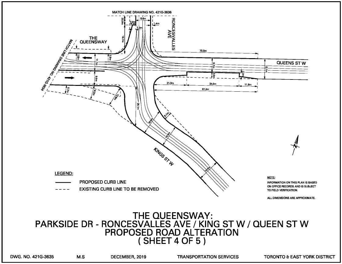
The Stage 2 of construction will be carried out on The Queensway from Parkside Drive to Sunnyside Avenue and on King Street West from the KQQR Intersection to approximately 100 m south thereof. This work includes watermain replacement and sewer relining on King Street West; TTC track work, road reconstruction and hydro works along The Queensway (Parkside Drive to Sunnyside Ave); reconstruction of the southwest corner of the KQQR Intersection including streetscape work at Beaty Boulevard Park (southwest corner of the KQQR Intersection); TTC overhead wire replacement along The Queensway, the KQQR Intersection and King Street West; and the rehabilitation of The Queensway bridge at Parkside Drive (inner lanes).
From this description, it is unclear which portions of the work will actually extend into 2022, and for what period the intersection will be impassible. That would determine the period during which streetcar service on the west end of Queen and King would have to be suspended.
Stage 3: April 2022 to August 2022
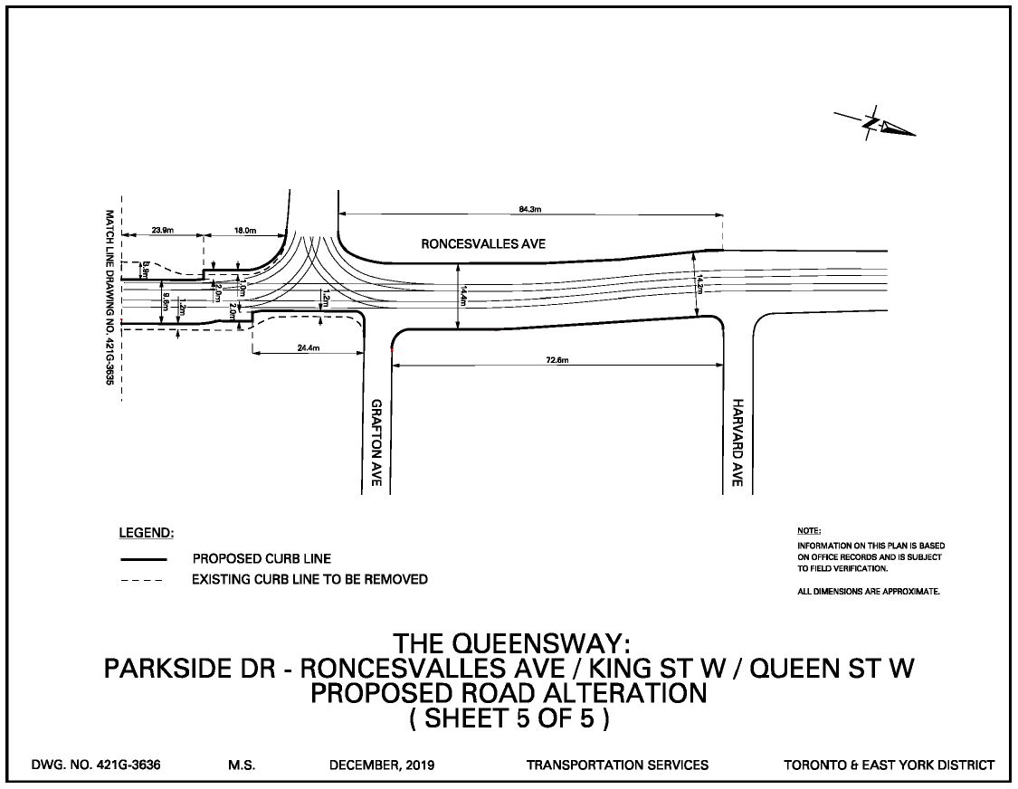
The Stage 3 of construction will be carried out on Roncesvalles Avenue from the KQQR Intersection to Dundas Street West. This work includes watermain replacement, sewer relining, TTC overhead wire removal and replacement, and TTC track work; and road reconstruction on Roncesvalles Avenue from the KQQR Intersection to Harvard Avenue. Stage 3 also includes minor work on Roncesvalles Avenue, from Harvard Avenue to Dundas Street West, to modify the TTC platforms for compliance with the Province’s Accessibility for Ontarians with Disabilities Act (AODA) requirements.
This stage involves Roncesvalles Avenue north from Queen including the North Gate at the carhouse. While this is underway, streetcars would not be able to operate on Roncesvalles, but should be able to use the South Gate.
I have sent a query to the City for clarification of the staging of this project.
The original article follow below.
Correction: This item was to have been approved by Council at its April 1, 2020 meeting, but that was cancelled. The item is still pending approval.
Update: This item was approved by Council at its meeting of April 30, 2020.
Toronto Council Infrastructure and Environment Committee recently approved the long-awaited changes at the intersection of King, Queen and Roncesvalles, and on The Queensway to occur in 2021. The detailed construction staging plan is not yet available, but the overall plans were part of the city’s report. This work had originally been planned a few years back, but was delayed for various reasons including conflicts with other projects and the desire to bundle all works affecting this area in one major undertaking.
The transit work includes extension of the “new” Roncesvalles street design south to include the stops just north of Queen, reconfiguration of the intersection between the four streets, and extension of the transit right-of-way on The Queensway from Claude (east of Parkside) east to Roncesvalles.
King-Queen-Roncesvalles-Queensway Intersection
This intersection, which has been the subject of iconic photos in the TTC’s history, will be reconfigured as shown below. The biggest change is the realignment of the approach tracks from King Street so that they meet Queen Street in a conventional 90 degree configuration rather than the angled approach today. At the same time, the eastbound traffic channel that allows traffic to slip past the intersection onto King Street will be removed.
The eastbound carstop will be moved farside with a bump-out platform similar to those used on Roncesvalles Avenue.
The eastbound approach to the intersection will include four lanes: streetcars (reserved), left turns, through, and right turns. With the farside eastbound carstop, it is clear that the City is not anticipating a lot of through traffic. Traffic signals will be changed to use only two phases rather than the lengthy three-phase cycle now in place.
This arrangement greatly improves the safety for pedestrians crossing to and from the southwest corner of the intersection which provides access to the bridge over the Gardiner to Sunnyside Beach.
Roncesvalles North of Queen
The stops north of Queen will be modified with bump-out curbs as on the rest of Roncesvalles north to Dundas so that there is direct loading from the sidewalk into the streetcars. The northbound stop will be shifted to Grafton Avenue rather than being just south of the entrance switch to the carhouse at it is today.
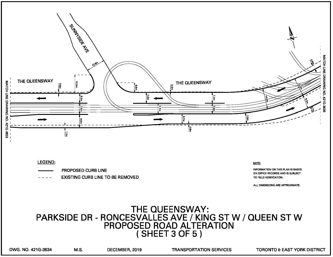
The Queensway from Parkside to Sunnyside
The right of way currently ends just west of Claude Avenue where streetcar and auto traffic merge. In the new design, the reserved lanes continue east on The Queensway, and it will no longer be possible to exit from Claude southbound to The Queensway eastbound. Northbound access is already barred by a turn restriction eastbound.
The bicycle lane on The Queensway eastbound that now becomes a sharrow just east of Parkside will be extended to Glendale Avenue.
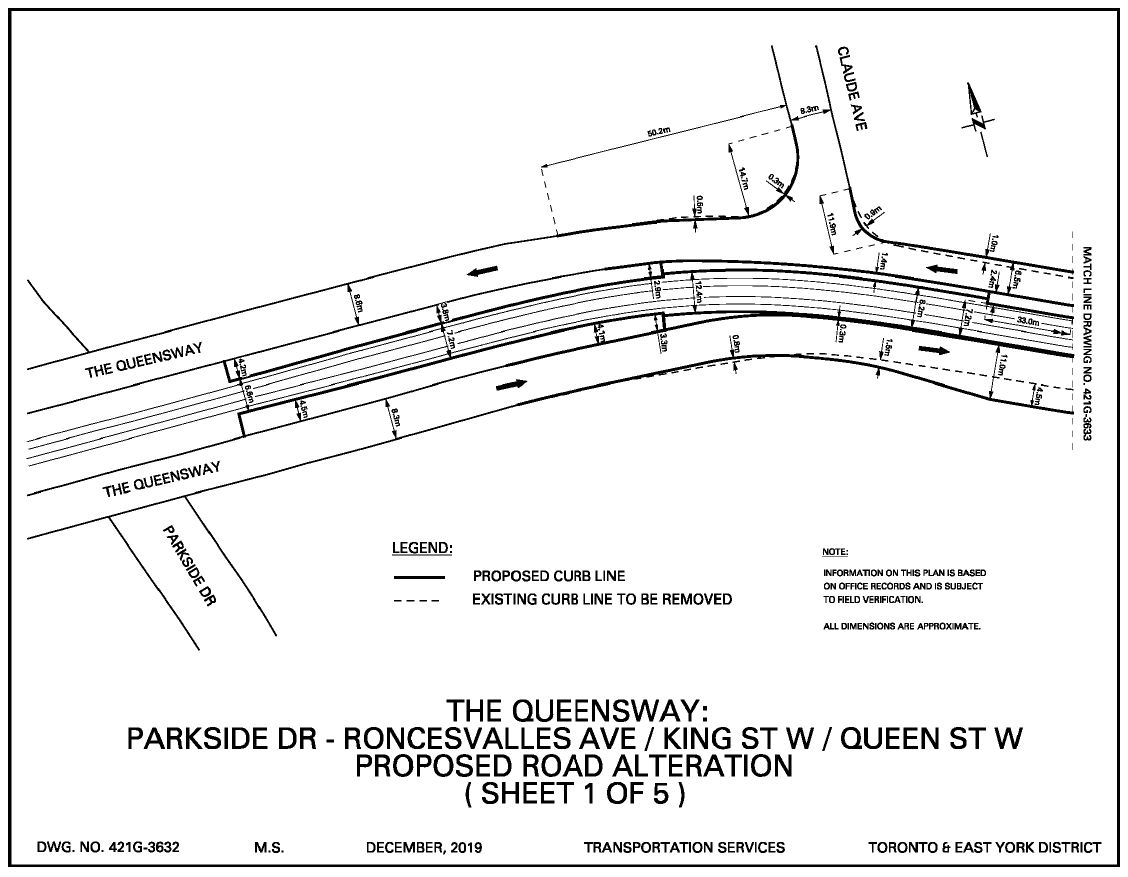
There will be a break in the right-of-way at Glendale to permit turns. This is the existing stop serving St. Joseph’s Hospital, but it will be changed so that the westbound stop is farside rather than nearside. The new stops will be designed to accessible standards.
A new left turn lane will be added eastbound at Glendale.
A short section of sidewalk will be added on the south side of The Queensway at the Glendale intersection, although it only spans the width of the intersection. This has always been difficult stop for TTC riders when buses replace streetcars because their waiting area is unpaved.
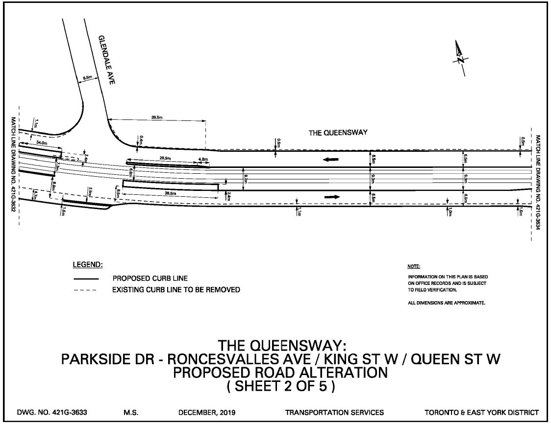
The right-of-way continues east toward Roncesvalles. The south side curb is continuous except at Sunnyside Avenue. The north side curb is open for much of the distance between Roncesvalles and Sunnyside because of the access tracks to the carhouse and to Sunnyside Loop.
Traffic signals will be added at Sunnyside Avenue to control movements across streetcar lanes, and to aid streetcars leaving the loop. A new left turn lane eastbound will be added.
The 1923 Reconstruction
In the early 1920s, the TTC inherited the worn-out track of the Toronto Railway Company and set about rebuilding everything to then-modern standards. The intersection at King, Queen and Roncesvalles was the single largest project, and there are many photos of this in the City Archives. Here are a few.
Looking southeast into King Street from the northwest corner at Queen Street. This approach to the intersection has been in this configuration for well over a century, but it will change with the planned work in 2021. Sunnyside Station is on the right edge of the photo.

Creator: Alfred J. Pearson
Date: April 7, 1923
Archival Citation: Fonds 16, Series 71, Item 1977
Looking north from King Street into Roncesvalles Avenue.

James Salmon Collection
Archival Citation: Fonds 1231, Item 1214
Looking westward down onto the intersection. The track layout is quite different from today because the TTC’s Roncesvalles Carhouse did not yet exist (the TRC building was further north and the primary access was from Roncesvalles Avenue). There is no fan of tracks into the car yard from Queen Street. Also, of course, many tracks – from King, Queen and Roncesvalles – lead to the Sunnyside Bridge to Lake Shore Boulevard West and Sunnyside Amusement Park. Queen cars operated via Lake Shore to Humber Loop which was east of the Humber River on Lake Shore Road.
This leg was removed with the construction of the Gardiner Expressway and the realignment of streetcar service north to The Queensway where it runs today.

Creator: Alfred J. Pearson
Date: April 19, 1923
Archival Citation: Fonds 16, Series 71, Item 2040
Looking northeast from the Lake Shore Bridge into Queen Street.
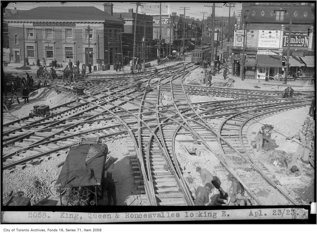
Creator: Alfred J. Pearson
Date: April 23, 1923
Archival Citation: Fonds 16, Series 71, Item 2058
Looking east on Lake Shore Road at Sunnyside. The streetcars ran along the north side (to the left). The intersection of King, Queen and Roncesvalles is visible in the distance just to the left of the centre of the photo.

Photographic ledgers of E.L. Ruddy Company
Date: Early 1930s
Archival Citation: Fonds 1488, Series 1230, Item 3974
The 2000 Reconstruction
The last time the intersection was rebuilt was in June 2000. This preceded the switch to “panel track” by the TTC, and all of the intersection was assembled on site.
-

- Looking south on Roncesvalles at the carhouse north gate
-

- Looking east from the carhouse north gate
-

- Looking west on Queen to Roncesvalles
-

- Looking west on Queen to Roncesvalles
-

- West of Roncesvalles looking east
-

- Looking east on Queen to Roncesvalles
-

- Looking east on Queen to Roncesvalles
-

- West of Roncesvalles looking west
-

- Looking west on Queen from Roncesvalles
-

- Looking southeast across Sunnyside Loop

I was wondering if you think the TTC will allow buses to use the Queensway ROW and the underpass at Humber loop, since the tracks are or will be in concrete up to the top of the rail, and if not then what is the benefit of the ROW tracks being in concrete up to the track surface level, as if it was on a regular street?
Steve: I doubt it. Even though The Queensway has side poles, unlike other rights-of-way such as St. Clair, my gut feeling is that as a bus roadway it’s still tight. Also that banked curve east of Humber Loop (too banked really) would be “interesting” for buses especially in bad weather. The underpasses would be tight without some sort of signalling especially the long, curving one out to Lake Shore.
All concrete? The reason given for this is that a lot of The Queensway is not on very strong ground, and the TTC spent a lot of time realigning the open track. Don’t forget that some of this is fill. Indeed, during construction, they had to redesign the pole bases to be more robust because the ground could not support them, and this delayed the project for several months. This was a side effect of using single large poles to hold up both directions of overhead with a cantilever design. South of Grenadier Pond the water table is very close to the surface. Large concrete bases were built there to support the poles.
LikeLike
Thanks! Great history. Wondered how often that iconic intersection had been rebuilt. 1923 to 2000 is almost 80 year lifespan. Hard to beat with any pavement, or even other trackwork.
Steve: The previous iteration to 2000 was a series of jobs in 1982 and 1984 with piecemeal replacement of sections, not a full rebuild. It is likely that a lot of maintenance was done section by section in previous years when they were still using paving setts, not concrete, and it was much easier to mine an individual casting out of the intersection as necessary.
LikeLike
I always thought that the intersection would be better as a roundabout. I wonder how much they considered it and if the streetcars have a turning radius that would allow a roundabout.
Steve: The intersection is nowhere large enough for that, and there’s the small problem of the drop to the railway and roads just to the south.
LikeLike
I look forward to the changes. Three years ago, while cycling eastbound, I veered left to avoid a series of grates beside the Parkdale Pumping Station. A taxi behind me wasn’t paying attention and sideswiped me, causing me to fall and tearing one of the ligaments in my right hand. A contributing factor was the fact that the bike lane ends abruptly just west if the station. In the proposed rebuild, the bike lane will be extended east, which will make it safer for cyclists.
LikeLike
I’m mixed about this.
I’m glad the intersection is being re-worked to improve functions; and don’t have any real issue with how the TTC is changing tracks. But it stinks for bikes, despite the tiny bit of extra bike lane being added to extend past a bad pinch point which I’m glad wasn’t fatal to J. MacMillan.
It’s actually being made WORSE for cyclists in some important ways, primarily at the K/Q/R/Q intersection, with two major problems – not the far-side boarding on Queen past Roncesvalles.
1) All vehicles pinch curves, and ‘corners’, and the TTC itself marks out the ‘trespass’ over the curvature of tracks with white circles. The NWbound proposed new curve/approach to Queen from King has a sharper curve, but foolishly, the City is adding a pinch point EXACTLY at the curve, so if there’s a streetcar, large vehicle and a bike, the bike gets squished. It’s as if they haven’t learned a damned thing from the death of Ms. Jenna Morrison – and that’s very bad.
Sure, put in a pinch point, but make the space of it only accessible for bikes by use of bollards or some other measure to allow permeability for bikes.
Steve: I assume that what you refer to here is not the north to west curve itself (which is a left turn), but the newly added curve as King Street turns north to face the intersection at 90 degrees. The drawings show a wider sidewalk adjacent to this curve.
What is missing from the drawings is an actual lane layout showing where there will be cycling reservations, or not, and hence where cyclists will be in mixed traffic with all that this entails.
2) That same issue with curves – especially the rightwards ones – rears up again as we go west from Roncesvalles, crossing over multiple streetcar tracks. They’re supposed to be crossed as tight to a right angle as possible to avoid being tossed/caught – but instead of marking off a bike lanes’ worth of space, again with bollards (or sure, use some concrete), the extra space that now has a protected parking spot is becoming a sidewalk and ANY cyclist that is going to High Park, or trying to go there, not only has a sharper angle of tracks to cross, but also has the squeeze of ALL the traffic pinching as it cuts right.
Steve: Short of a complete redesign of Roncesvalles carhouse’s trackage at the south end, this is not going to change. All of that track is brand new and the time for modification has been missed. There would almost certainly be tracks crossing the westbound road lanes here and I’m not sure how this could be avoided.
Yes, I went to the deputation, filed materials, and was ignored, and five minutes wasn’t enough.
It’s also appalling that there’s no real interest in ensuring that a very long and very good by our standards of bike lane on Queensway in from Etobicoke is simply abandoned, with maybe an allegation that there’s not enough room. No, it’s a problem of imagination, will and maybe the Gardiner – as there’s plenty of space there, including beside tracks, but the highway designers of our City refuse to make sure that there’s any filling in of a gap, or bending uses to combine a sidewalk with a valley ‘curb’ on the south side so that at least we could mount up easily on to a sidewalk of simple asphalt to allow us to get off the highway.
Parkdalians deserve to be able to bike to High Park safely; some Etobicokians do bike, and do deserve ongoing safety from having 4kms of good bike lane instead of being tossed on to a highway. Some of the staff and politicians deserve very clear personal liability for any and all harms including deaths from really bad design for bikes in this project. And it’s clear that 30 years after the Toronto Target, there’s really ZERO interest in actually having safe cycling as part of a climate response, so there’s another round of liability, in my view, and we’re stinking bad as it is.
This should go to a chart from an Easterbrook at UofT charting our pathetic GHG showings:
Bikes don’t work for everyone, nor in all seasons, especially when the snow is plowed in to the bike lanes, but increasingly, there are higher numbers, despite the many hazards, which still include the streetcar tracks and the near-rubble of the margins closest to the curb. Yes, at times, a cyclist is stupid, selfish and endangering peds/transit users, and not just themselves, but it’s pretty rare that a cyclist kills someone, and yes, we do hear about that.
LikeLike
I often seen backups of westbound 501 streetcars entering the Humber loop. While having maybe 3 CLRV’s would be handled almost okay, having 3 LFLRV’s is problematic. There should be temporary bypass westbound tracks at the Humber Loop.
Until the “Park Lawn” transit hub goes into operation (next century?). Hopefully, the streetcar loop at the “Park Lawn” loop will include bypass tracks.
As for the Roncesvalles, Queen, King, Queensway intersection, has any recommendations made for “enhanced streetcar network” (501A, 501B, etc.). Like where the streetcar stops would be located IF they implement that recommendation?
Steve: The problem with cars backing up at terminals is a chronic effect of the TTC’s padded running times. The desire is to drive short turns to zero because this gives Rick Leary a gold star, but it wastes vehicles and complicates terminal operations. In effect, the TTC is scheduling for worst case conditions that don’t apply most of the time.
Park Lawn Loop has two tracks planned, but one is for the Long Branch service, not as a Queen bypass. Whether we will ever see this loop is quite another matter.
As for the rejigged streetcar network, that farside stop eastbound at Roncesvalles on Queen is going to be a problem. The nearside stop was sacrificed to keep the good burghers of Sunnyside happy with a dedicated left turn lane. I also suspect that there will be greater delays because of the 90 degree turns to and from King rather than the current angled arrangement. Maybe there will be transit priority signals. Maybe they will even work. I am not holding my breath. Every “transit priority” arrangement added on the west end of the Queen route has slowed service, not speeded it. “Priority” should mean “the traffic can damn well wait now“, not “the streetcar gets to move after everyone else is out of the way”.
LikeLike
If I’m not mistaken, the 508 was brought back last year and is still running right? Though I’m guessing not during the quarantine. It looks like this configuration has no eastbound stop for streetcars turning from Queensway to King. Also, is the southside northbound stop on King being retained? It looks like it would now be on a curve. Even if the 508 wasn’t running, it seems like it would still make sense to protect for Queensway-King service.
Steve: Yes, the 508 came back for a while, then as a bus, then back to streetcars, and now suspended with all of the other peak period services. I really don’t know where there will be an eastbound stop after this change is implemented.
LikeLike
The Glendale Avenue stop has to remain, to provide wheelchair accessibility to St. Joseph’s Health Care Centre. The Parkside Drive remains inaccessible to wheelchairs, no elevators.
However, the city should still provide a signalled pedestrian crossing at Parkside Drive. The closest signal crossing is 150m north at Spring Road or 150m south at Lake Shore Blvd. W.. Currently, not very convenient for the 80 QUEENSWAY transfers.
LikeLike
This looks like a good iteration, if not a revolution. It would be nice to have more dedicated right-of-ways but that’s not going to happen without a commitment to significantly reduce car trips – that’s a complaint to Council, not to TTC and maybe not even to Transportation Services.
It will be a lot nicer for pedestrians. Of course anything would be better than the current misaligned crossings with rubbed-off paint on broken concrete – but the general squaring, and the removal of the high-speed ramp southeast-bound will be a real improvement. Some of the curb curves still seem a little generous. What’s with the asphalt space on northwest corner, what is its purpose, why can’t it the curb be aligned to the turn track as on the northeast corner? And why is the right lane on southeastbound King so very wide at first? But it’s an improvement.
Regarding cycling. It could be better. I’m not sure if it would be feasible to use Roncesvalles entrance to the carhouse instead of so many tracks branching off Queensway – I can guess it wouldn’t be as easy. There’s a large chicken-and-egg problem in that none of the remainder of the area is cycle friendly. Leaving aside the low comfort level of painted lanes on highway-like Queensway east of Colborne Lodge – so if we got lanes on Queensway all the way to Roncesvalles – what then? Queen and King are both very much not cyclist friendly. I am very interested in cycling in this area but as far as I can see, currently the best options are to either walk across the footbridge and take Martin Goodman Trail, or somehow trudge to Brock Avenue where it’s possible to join the Florence-Argyle-park-Richmond corridor. It’d be very nice if we got a Lake Shore-through-Mimico style track on Queen or King (converting one curb/parking lane) – but if we do, continue it along Queensway to Glendale and avoid the streetcar yard entrances that way. Until we do, for long-distance commuters Martin Goodman is way better, and local traffic is better served on side streets – and the Queensway connection to Glendale allows getting to Pearson-Seaforth corridor to Brock (return trips are harder due to car-oriented one-way street system but that’s yet another story).
(Parkdale access to High Park is possible via Dowling-Martin Goodman-Colborne Lodge and Beauty-Sorauren-Fermanagh or Sorauren-Galley-Garden. Yeah they’re not straight corridors. Call the Mayor and Councillors about reassigning road space.)
Regarding roundabouts – the intersection is too small on the east side; and in European usage, trams go straight through roundabouts – but then in European usage they don’t usually have trams every 3 minutes that don’t have their own right of way.
Regarding the “enhanced streetcar network” service pattern, this intersection would be busier but not much different from, say, Queen and Broadview. Which is to say, it’d mostly need real, effective transit priority.
I wonder if TTC would get rid of the Triller Avenue stop(s) given the eastbound stop’s proximity to the relocated far-side Roncesvalles stop… or will we get another absurd stop spacing like Jack Layton Way or Joe Shuster Way?
LikeLike
Thanks for both posting [the] comment, and the refinement of the two major concerns, the third being filling in the gaps in the network and ensuring that Parkdale, a NIP, isn’t kept caged in by unsafe streets.
With the first design issue on King St., (which that stretch was in the 2001 Bike Plan for a signed route and…. ), yes, it’s the addition of a bump-out on King St. with the curve pinching us that is the problem. The safer thing to do is to put bollards up, or concrete even, and let bikes keep the existing straight line of the street, in between curb and bollards till past the cuerve.
2) Yes, the tracks exist, and will continue to exist, going west from Roncesvalles on the north side of the Queensway. But as it can be harrowing to cross over these tracks, rather than pushing the sidewalk about 2 meters out, and pushing the cyclists out further, while not using the existing sidewalk space, create a bit of separated bike lane in that really awkward stretch to a) keep the cars out from us during the pinching of the curve as they gain access to highway, and b) give us safer crossings of the rails, which ideally should be at 90 degrees, but which doesn’t always happen.
Both of these are really simple cheap things to do and should be no-brainers, if, IF cyclists’ lives are valued, especially on main direct routes, and the Queensway is the most direct way to High Park from Parkdale.
The pattern of harm/crash in Toronto’s core consistently shows up the main east-west roads, and doesn’t include streetcar track tossings/harms, and occasional death, some not being so easy to determine as guess what? Someone can’t say what happened. But of the serious bike crashes requiring hospitalizations, a BC study led I think by Kay Teschke found that a third of those were related to tracks, so it’s a serious set of issues/costs.
Elsewhere in this gap, on the straightaways, there’s extra room in between tracks and the lane beside them, but to advantage bikes in between these gaps, would mean slight curves, and not the 70kmh or 80 kmh design speed we now have.
Steve: If the study you refer to is the one that was reported on some time ago by the Star, there is a methodology issue with it because the data was from Toronto Western Hospital which is right in the middle of streetcar territory. This was erroneously extrapolated to claim that a large percentage of cycling injuries in the city overall was caused by streetcar tracks.
That said, there is a big problem with fitting everyone onto the roads especially as the balance between modes changes, and the need for real networks, not disconnected bits and pieces where there was a chunk of roadspace left over.
LikeLike
I am disappointed the intersection reconstruction will not see the Queensway bike lanes get extended all the way to Roncesvalles to connect with the bridge. I first suggested this 5 – 6 years ago and was informed the reason this wasn’t possible (beyond Glenlake) is Metrolinx space constraints.
LikeLike
On a procedural matter: on City website I’m seeing the item for this (IE12.9) was to be considered by City Council on April 1, 2020. Was it actually considered and approved, does it still have to be approved, or is that considered to basically be a rubber-stamp whenever Council resumes?
Steve: It still has to be approved by Council. Thanks for catching that. I have updated the article to reflect the current status.
LikeLike
Very glad to know that it’s not fully approved, though I don’t have any issue with reworking the tracks at the intersection, and hope that the order is placed soon, as I believe it’s a very long lag time between ordering specialty/complicated tracks, and delivery, as you informed us all at some point/post, thanks.
Actually, I have real issues believing that the lack of land on the south side for bike safety width is a real reason if the retaining walls and tracks are any indication. And it isn’t always a bike lane that makes things safer, but extra width (though bike lanes are better), and a lower speed, which is influenced by design/lane widths.
With track crashes, yes it may have been only two hospitals, but the bulk of cyclists c. 2/3 of us, are in the core, and as you observe, the bike network is far more of a notwork/patchwork and not the direct, linked, safe travel all other modes have. It’s especially galling here in that we have a truly excellent long bike lane in Etobicoke leading to the core that is still going to be abruptly ended on a highway without a good connection, as well as a NIP area (Parkdale) that is being caged in away from High Park by unnecessary danger.
While bikes are competition to the transit, (and can be passholes to some transit users). and we represent a competitor for the entitlement of space of the commuter SOVs, it’s the vehicle of this greenhouse century, and some Euro countries actually pay cyclists due to the health benefits of biking. Amusing eh?; and we’re world-last it can feel like.
LikeLike
Just a question about bike ROWs. Would it be possible to put one on the south side of the Queensway as least as far as Howard?
Steve: There already is one there, but it ends abruptly just east of Parkside.
LikeLike
From what I’ve seen, by far the most traffic at the eastbound Roncesvalles stop is to transfer to an eastbound King car. Putting this stop farside means having to use two pedestrian crossings. This argues for a farside eastbound (south) stop on King. That would also resolve the question of the 508, which seems to come and go as do the clouds in the sky.
LikeLike
Thanks, Steve. Years ago you came to a Roncesvalles Macdonell Residents Association (RMRA) public meeting to speak on this plan. If I recall correctly, back then you pointed out the potential problems from traffic jams that will result due to moving the eastbound stop to the far side of Queen and the elimination of the angled pass-through lane from Queensway to King. That seems to be consistent with your views today, yes?
As well, Hamish Wilson has some very valid critiques of the lack of consideration for bicycle traffic in the overall redesign. Another concern is the continuation of the practice of re-engineering the roads with these bumpouts, which have proven to a source of much controversy on Roncesvalles where the city/TTC has first tried this bumpout experiment. It was for these reasons, and the overall indications of “feature creep” that could result in yet another massive construction bungle, that the RMRA opposed the plan when it was first presented in 2015.
Steve: I really don’t like the shift of the eastbound stop farside, and this move was done not for traffic reasons, but to placate the folks living west of Ronces with a left turn lane. It would have been possible to normalize the intersection and get rid of the slip lane eastbound without shifting the carstop.
LikeLike
A lot has changed with that intersection since even before 1887.
Map of Humber Bay 1884
The original Sunnyside
From Sunnyside Historical Society
LikeLike
… and if this plan does get voted down by council, I hope the Roncesvalles Macdonell Residents Association will join me in advocating for an even more transit- and active transportation-friendly design for the area. Queens Quay West comes to mind and its right-of-way is of similar width as Queensway near the intersection: an off-street bicycle path, off-street transit path, one through car lane per direction, one left turn lane, and certainly no “controversial” streetcar bumpouts. Realignment of the intersection to feed Queensway into King more directly would allow for a T-intersection with Roncesvalles and help make way for low-car Queen. Could be quite nice in 2030!
Oh wait – concern about feature creep? I’m sure RMRA wasn’t wishing simply for the car-centric status quo with a greenwashed unprotected bike lane, were they?
LikeLike
Turning now to the traffic lane widths for The Queensway. Are they designed for the “suggested” speed limit of 50 km/h, the old 60 km/h, or for the “safety” of speeders doing 100+ km/h? Motorists would slow down if the traffic lanes were actually narrow. They could leave room for a raised bicycle lane in each direction.
Steve: The report does not include detailed lane design information. I would have expected this to come out at public sessions planned later this year before the whole covid business put everything on hold.
LikeLike
I’m very glad of this open forum, and inputs from various people.
Yes, to echo Walter Lis, what are the design speeds? Now, and proposed? And since there’s a metre or so of space between track edge and middle lane that is usually empty, if we thought of adding some slight curvature to the car traffic lanes, that would help make room at the curb lane for the bike traffic. That might lower design speed to 50 kmh or 40? So why not??
Yes, Jarek’s got points about how less-good existing conditions are, including King and Queen, but since there’s about 4 kms of good bike lane on Queensway already, it’s ridiculous to not make them go continuously to other options, where King is better than Queen, absolutely, (and is that curb lane of Queen actually 3M? It feels tight.). And King was part of 2001 Bike Plan as a signed route, but nothing’s happened thus far, only near two decades, so be patient, right?
Roncesvalles is less-OK in some ways too; yes, but it’s also a bit better than Sorarsen as I call it, because the pavement is horrible, going northbound especially. Sorarsen is one of the more feeble efforts at bike infra, sigh, but the City is able to get away with a lot.
Having RMRA interest or any other interest from area residents expressed to Cnclr Perks would be excellent; perhaps the online meeting of Council for April 30 might approve a whack of things, including this one, though I don’t have problems with any of the track changes.
And yes, final point about the multiple track entries/crossings on westbound Queensway on north side. Obviously can’t take out the tracks and make smooth cycling, but instead of taking away space for westbound cyclists and putting us in to harm’s way from both vehicles, and a bad angle for crossing the tracks, here – for a short bit of the road – would be superb to have a set of bollards or a concrete block or three to separate out bike traffic on the curve, and give us the safety of slow crossings at a good angle.
LikeLike
With the lack of public meetings I suggest anyone with useful ideas should email or talk to the local Councillor – in this case Gord Perks. If improvements are to be made it is best that Staff have not already made decisions!
LikeLike
If the main reason for the farside eastbound stop is to give a left turn lane for eastbound cars to go north on Roncesvalles, then it’s a lousy design and it will inevitably slow streetcars down.
The current left turn arrangement for eastbound to Glendale is unorthodox, but it works well. I don’t think I’ve ever experienced an accident due to the setup. Compare that to cars making left turns further west along The Queensway, where inevitably someone will turn left on a red left turn signal.
Making everthing more elaborate and “safe” means slower operation for streetcars. At least in Toronto.
LikeLike
re: Ed at 7:32 pm …
Everywhere with trams in a dedicated right of way uses a separate left-turn cycle where left turns are allowed. It’s a completely standard way of designing an intersection.
If there are concerns about accidents, they must be laid at the feet of car drivers.
If there are concerns about operating speed (and in Toronto there are), they must be laid at the feet of Transportation Services and TTC management and Councillors who don’t push for actual transit priority in “transit priority” signalling. Give the streetcars a 10-second clear before the car cycle starts. It’s not a difficult implementation.
Going with a shared lane where just one turning car holds up a streetcar with 100+ people on it because drivers run reds or because we won’t program a cycle to have the streetcars go first would be so very Toronto.
LikeLike
My observation that the Glendale shared track/turn lane “works well” includes the fact that it rarely holds up the streetcar.
I think that this chart shows it.
The speed through Glendale doesn’t drop as low as speed through some other Queensway intersections.
If there’s a better chart, I did not find it on a quick search.
The separate arrangement no doubt works very well, but if we don’t get a good streetcar priority setup in Toronto, then streetcars will be slowed down by any signal “upgrades”.
Another thing comes to mind, though. I’ve been on many a 501 that pauses at Roncesvalles for several minutes for an operator change (seen in the very low speeds through Roncesvalles on the chart). How is that going to work with the far-side stop? Will the streetcar stop somewhere nearside at not-a-stop? In which case, passengers who are looking to get off at Roncesvalles (and it’s a busy stop) will be left twiddling their thumbs on the streetcar.
Steve: Or if the car stops farside for an extended wait on a replacement operator, no traffic will be able to get through. There is a general problem with crew changes that do not occur as promptly as they should at some locations, but without as much potential effect on traffic. I wonder how long it will take for the TTC to decide to only do westbound changes.
LikeLike
Hey! Thanks for this! Family live a couple blocks north of Queen on Roncesvalles so I’m familiar with the area some. The last several visits have, sadly, been urgent family-type trips (mine not his) so my TTCing has been limited to a 504 car to Bloor to catch the UPX to YYZ. I hope to remedy that after the virus has finished its killing spree.
However … the “Lake Shore Bridge” thing and the historic images had me all confused. Some power-googling lead me to this article and now I am significantly less confused and simultaneously better informed. 🙂 I can’t help but think that powerlines in the lake had more to do with the demise of Sunnyside’s popularity than the shift from streetcars to motorcars – what a way to ruin a lakefront!
Steve: The Gardiner Expressway wrought destruction of a lot in south Parkdale. The power transmission corridor had been there for quite some time before as the images show. It’s not there today but was shifted further north, it ends at a substation just east of South Kingsway. This entire area, as you can see from the maps and photos, was substantially rearranged when the Gardiner was built.
LikeLike
Approval of the changes to this intersection are coming to the Special Council meeting on 30 April.
IE12.9 – Improvements at The Queensway, Queen Street West, King Street West and Roncesvalles Avenue Intersection to Improve Safety, Operations, and Extend Bicycle Lanes (Ward 4)
Steve: The report was adopted on April 30, 2020.
LikeLike
I’m very glad DavidC has cued everyone to this approval – input via councilmeeting@toronto.ca
No issues with re-arranging the streetcar tracks, but it’s the rest of the highway, and making sure that Parkdale isn’t deliberately caged in again by not high-risk cycling, since WHO is saying we should bike/walk places, and Paris is reacting, as one eg. beyond Caronto.
Imagine, 72% of parking spaces taken away….
LikeLike
This is only tangentially related, but interesting nonetheless:
Google aerial image of a streetcar intersection being fabricated in a Riverside parking lot.
Steve: The TTC used to assemble intersections at Hillcrest before installation, but now this work has shifted to a yard in the eastern waterfront.
LikeLike
You said that this streetcar related work approval will go before the committee on July 9 and before city council on July 28-29 but it is supposed to go before city council only if the committee approves it which everything related to streetcars is already written in stone and pre-approved regardless of its merits or rather the lack thereof.
Steve: This program was already approved back in April as the earlier part of the article points out, and this has been in the planning stage for a few years. So, yes, it is “pre-approved” in the sense that Council has already approved the work, and this is only the contract award. Nice try.
LikeLike
Regarding “north gate” (tracks entering from Roncesvalles): it is currently blocked off and concrete starting to get ripped up, I guess they are able to start reconstruction of it already since it’s not public roadway?
Steve: Not sure why they are working there now. Possibly doing the portion that is not in the street to get that part out of the way.
This project has been delayed a few times already. It was in the works a few years ago, and finally ready to roll in 2019, but the City somehow screwed up issuing the contract and it was cancelled. 2020 was a no-go because with pending work that will close the connection on Dundas later this year, the entire west end of the streetcar system would be isolated. Hence, 2021.
LikeLike
Unless changed, they will be installing signal lights at the Sunnyside & The Queensway intersection. It’s good news or bad news, that they are finally putting in signal lights on the Queen Street West extension that was built in the 1950’s.
Assuming no chance of real transit priority signals. Assuming the left turners from eastbound The Queensway to Sunnyside Avenue, will get priority ahead of any streetcar.
Steve: Yes, I fear this will be another “transit priority” scheme that will prioritize motorists, not streetcars. That’s the Toronto way.
LikeLike
It’s a topic that’s been beaten to death, but is there really no chance of the city / TTC ever figuring out a couple of new areas where diversion track can be put in place? Adding curves is sometimes difficult due to existing infrastructure, but there has to be a couple of streets in the city that are wide enough to offer, even one-way, non-revenue track.
Steve: There are only a few streets that link the downtown network with the west end, and two of them (Queen and King) pass through the KQR intersection. College and Dundas share a link west of Lansdowne. It’s not as if there is another east-west street to make an easy connection because of the rail corridor.
LikeLike
Re: A roundabout, the city could theoretically purchase the buildings adjacent to their yard from Harvard down to Queen, re-align the whole damn thing properly and create a more organized junction the way they did with 6 points. Use the leftover land as a development to recoup the costs.
Steve: Just what we need. Destroy the neighbourhood to get improved traffic flow.
LikeLike
Will there be any cars running on Lake Shore Blvd. during all of this? Could they do something like they’re doing on St.Clair right now? They could store them at Kipling, Long Branch and Humber Loops, But they would need someone to watch the cars overnight that wouldn’t be used for the Blue Night Service to make sure that they wouldn’t be vandalized.
Steve: The problem is that the cars would have no carhouse for routine maintenance and cleaning. St. Clair is operating from Hillcrest. Some cars are stored at St. Clair West which is a single, controllable location for security. Also while the intersection is closed, any streetcar service will extend at most to Dufferin. It would not make sense to have a bus shuttle that required two transfers to get downtown from Long Branch.
LikeLike
Looking at your pictures from 2000 it looks like they poured a foundation for the tracks. I know for tangent track they are able to remove only the upper layers of concrete to speed rail replacements, but in that case the ties stay in place. Do you know if (with the exception of the realignment of the Queensway to King curves) they can leave that lower slab in place and put the track panels on it to save some time on the reconstruction?
Steve: In theory, that lower slab should remain in place. Whether anyone remembers it is there, and designs this into the project, remains to be seen.
There is also a potential problem in that some of the jobs from that era did not include a mechanical separation between the layers of concrete. This makes is hard to remove the upper layers without damaging the foundation. The TTC ran into some track like this on Lake Shore during its reconstruction a few years ago where a planned “top level only” replacement turned into something more. We shall see what’s really “down there” next year, and how much of the 2000 foundation is reused. Typically what is used to isolate the slabs is a thin layer of sprayed on tar.
LikeLike