
After leaks to the Star and the Globe, and a private release to the City of Toronto, Metrolinx made public its Initial Business Case for the Ontario Line, Queen Park’s proposed alternative to the Downtown Relief Line.
The entire document reads as if it were drenched in perfume with a rosy comparison of a modern, inexpensive Ontario Line to an expensive DRL complete with outmoded technology. It is as much a sales manual for the Metrolinx proposal as it is an apples-to-apples comparison. Indeed, the DRL comparator is doomed to look worse simply because it is the shorter version of the line. The intent is to convince the reader that no reasonable person would support any other scheme.
The chart below is one of many that inevitably shows the OL as superior for the simple reason that it covers more ground. The question is whether it can all be built for the price quoted and in the projected timeframe. There may be arguments for parts of the OL compared to the DRL, but the Metrolinx comparison goes out of its way to denigrate the DRL wherever possible and in the process reveals some short-sighted “planning” that is more a question of scoring political points than of giving a technical comparison.

Any new rapid transit line, regardless of technology, cannot help but succeed in the DRL/OL corridor given the density of population and jobs along its length. Contrary to the long-established Toronto practice of building rapid transit where politicians and their developer friends hope to spur local centres away from downtown, the DRL/OL corridor is packed with potential demand already. Even more demand will come from provision of an alternate route into the core from the existing crowded subway network.
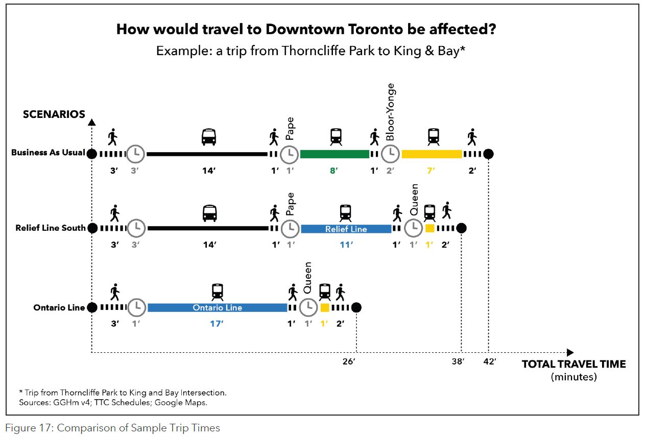
Travel times from Thorncliffe Park and neighbouring areas to the core are substantially improved by a new line, no surprise at all.
Planning for downtown growth is years behind what is actually happening.
Population and Employment growth in Downtown Toronto has accelerated, and has already exceeded 2031 forecasts. Population growth is also very high in the Downtown; however population density itself is more diffused, with pockets generally along existing subway lines as well as in neighbourhoods with lower average household incomes. [p. 19]


At this point, the OL cost estimate is very preliminary because there is no detailed design for the line. From experience with other Toronto projects, we know that there is a very wide margin for error in cost estimates. Metrolinx flags several potential issues along their route, but gives no indication of how these might affect the design, the cost or the potential construction period. It is simply not practical or reasonable to give a “business case” or a “cost benefit ratio” when there is such a huge potential variation in the estimate.
Moreover, Metrolinx gives a discount to the Ontario line on the dubious pretext that with risk transfer to a private sector partner, the costs incurred will be lower. This depends on a very well-written and managed contract, as well as an owner (the province) willing to hold a loaded gun to the builder’s head if they don’t deliver. The 3P (a purpose created coalition) always has the option of going bankrupt, or asking for an enticement as happened to get the Crosstown project back “on time”.
CEO Phil Verster was filled with optimism speaking on CBC’s Metro Morning, but somewhat more guarded talking to The Star’s Ben Spurr:
On Thursday, Verster gave his clearest acknowledgement yet that it’s possible that date could end up out of reach.
“(The deadline of) 2027 is hugely ambitious,” said Verster, but “this is the time for us to be ambitious.” He asserted that by building much of the line above ground, it can be completed quickly.
But, said Verster, that when Metrolinx starts the procurement process next year, if the bidding companies say “it can’t be done in 2027,” his agency “will declare that immediately.”
That’s all very well, but delivering the full OL two years before the proposed completion of only the DRL South segment from Pape to Osgoode Station is a big selling point, along with the lower pricetag. Get double the line at only a modest extra cost, and get it faster. Who would choose anything else?

Does SmartTrack Still Exist?
There was a time when mayoral candidate John Tory conned Torontonians with the lure of SmartTrack, a service that would exploit spare capacity in the GO network to provide a “surface subway” carrying hundreds of thousands of passengers daily with frequent service at TTC fares. Over the years, SmartTrack has dwindled to a handful of new GO stations where current Metrolinx plans will provide trains every 15 minutes, a far cry from what was sold to voters. Frequency is critical in making a service attractive especially if actually using it requires riders to travel out of their way to reach stations.
At one point, Tory claimed that SmartTrack would make the Relief Line unnecessary. The rising crisis in subway capacity forced him to acknowledge that both the RL and some form of ST would be useful with each serving a different market.
The IBC for the Ontario Line does not mention SmartTrack by name, and the ST station at Gerrard appears to have fallen off of the map. The remaining potential ST stops are labelled as “proposed” GO rail stations.
Metrolinx cannot make up its mind whether it is a regional or a local carrier. A common political problem is the assumption that there is extra capacity for moving passengers within the City of Toronto when an attempt to achieve this could work against regional goals. Fare policies originally discouraged short haul trips, but then were changed to make them more attractive both on GO itself and for GO+TTC travel. Recently, however, the long-term availability of provincial subsidy for this policy is in doubt, and GO expects municipalities, already suffering from funding cuts, to make up the difference.
The IBC is quite clear about GO Transit’s role, at least from the point of view of its authors.
Metrolinx is now investing more than $20 billion in the GO Expansion program to expand the rail system, with faster and more frequent trains and the capacity to carry three times as many passengers by 2041. GO Rail will continue to serve primarily longer-distance trips, and is being developed in existing corridors with all trains running to or from Union Station. However, the GO Rail system does not serve all parts of Toronto, nor does it serve many shorter distance trips. [p. 14]

A final irony lies in the shared parentage of both the Ontario Line and SmartTrack by a consultant who once worked for the Tory campaign and now enjoys a senior role at Metrolinx.
“Modern” Technology
Metrolinx routinely dismisses the TTC subway as yesterday’s technology by reference to the use of large, manually driven trains and the TTC’s “bespoke” track gauge.
In fact, plans for the DRL included full automation with stations using platform edge doors, and the only real question would be whether there would still be a one-person crew on board.The IBC acknowledges that with headways in the 90 to 120 second range, the DRL would be capable of 33-44K/hour capacity, easily covering the future demand projection for this route. The capacity range cited for the alternative technology is 29.3-34K per hour.
As for the gauge, that is a legacy of a decision in the 1940s to build the subway to the same gauge as the streetcar system (4′ 10 7/8″ or 1495 mm) as against standard gauge (4′ 8 1/2″ or 1435 mm). Contrary to Metrolinx claims, this does not impose a pricing penalty on equipment especially when large numbers of vehicles are procured in a batch. However, it does give them a talking point with which to bash TTC plans for those who don’t know any better.
The IBC makes an outrageous claim for standard gauge equipment:
Generic standard gauge technology, which enables competitive procurement and protects for possible future extensions onto GO rail tracks. [p. 31]
The rolling stock that would be procured for the OL cannot interoperate with mainline rail services for a variety of reasons including crashworthiness, station design (platform height and location), and the simple fact that a frequent “metro” operation would leave no room for other trains. Statements like this show that the Metrolinx authors do not understand their technology and are willing to say anything to hype their proposal. This needlessly undermines their credibility.
Bombardier is churning out TTC gauge cars for the “legacy” streetcar system and standard gauge versions of the same vehicle for Metrolinx and Kitchener-Waterloo’s ION line. The challenge for the TTC streetcars has more to do with steep grades and tight curves than with the gauge of the track. These constraints do not apply to the subway system.
[Corrected] Historically, Toronto’s streetcar system was built to a broader gauge to allow wagons to use the groove in horsecar rails when navigating muddy streets. This was a condition of the original Toronto Street Railway Company’s franchise in 1861.
The franchise also required the TSR to provide sleighs in the event that snow made horsecar operation impossible. It is unclear what approach the Ontario Line will take.
There are arguments to be made for building part of any new line at or above grade, but this option simply was not on the table in a political environment where only “subways” were acceptable for transit proposals. Moreover, any scheme to build within the GO corridor would be routinely met with “GO away” from Metrolinx who wished to preserve any available space for their regional operations.
Clearly, the rules have changed.
The Alignment
The Ontario Line’s alignment has evolved since the original announcement, and even now it has not really been pinned down.
It is the “representative alignment,” for purposes of this Initial Business Case. The alignment will evolve throughout design development and procurement, as more information is known about geotechnical conditions, built and natural environmental impacts, potential development integration, and other factors. [p. 30]
In other words, the design cannot possibly have progressed to a detail level because factors not yet explored could change what is now only a doodle on a map subject to refinement.

Contrary to original claims that the OL would share much of the DRL’s alignment, and hence the design work already done on this, only two segments of the OL duplicate the DRL: On Pape from Danforth south to the rail corridor at Gerrard, and on Queen from east of Sherbourne to Osgoode Station. The rest of the OL is on a completely new alignment for which no preliminary engineering work has been done.
Three portions of the line would run at grade or on elevated structures:
- At Exhibition Station east to about Strachan Avenue.
- From east of Cherry Street parallel to the rail corridor northeast to Gerrard.
- From the south side of the Don Valley at the north end of Pape across to Overlea Boulevard, and thence east and north to Don Mills and Eglinton.
The section along the rail corridor presents a number of problems that Metrolinx has not addressed including:
- The availability of space in the corridor for four GO Transit tracks plus two OL tracks, not to mention space for station platforms and access/circulation structures.
- The lateral separation requirements between main line railway operations in the GO corridor and the light metro technology proposed for the OL.
- The space required for electrification structures for the GO operations (support towers, overhead catenary).
- The space required for SmartTrack stations platforms.
- The implications of the OL tracks bracketing the GO corridor rather than running along the north/west side of it to provide “across the platform” transfer capability at East Harbour Station.
The northeastern part of the OL would be an elevated structure on Overlea Boulevard and on Don Mills Road. This may run into less opposition for the visual intrusion by the structure than in the Riverdale segment because much of the area is not built up close to the road. Only at stations would there be a substantial presence over the street for platforms and access structures. Actual neighbourhood reaction must await detailed design proposals which are notably lacking in the IBC.
Gerrard Station
The corridor through Riverdale is tight and Gerrard Station has many potential problems. Here is the Google Maps view of the area.

Clearly visible on the bridges crossing Gerrard and Carlaw is a provision for a fourth track that GO plans to add to the corridor. This is required to give a pair of tracks to the Lakeshore East service, and a pair to the Stouffville service.
The OL would emerge somewhere in what is now a shopping centre to come from a tunnel under Pape and turn southwest in the corridor. The simplest station location would be on the north/west side of the GO tracks because this would avoid the need to rise up enough to get over them. However, as we will see later, Metrolinx proposes that the OL tracks straddle the GO tracks and this means that at least the eastbound/northbound OL track must go over or under the rail corridor.
A particular problem here is the proposed SmartTrack station whose platforms would be adjacent to the outer two tracks of the GO corridor. Space for these as well as access paths and structures must be included in considering the total right-of-way needs. If the Gerrard ST station has actually be abandoned from GO plans, this should be stated explicitly. It never made much sense with a DRL/OL station at the same location, and a joint station nearby at East Harbour.
Logan Avenue and Dundas Street Crossings

As at Gerrard/Carlaw, there is clear provision for a fourth track on the existing bridges that would be build along the south/east side of the corridor. No station is planned here, and so the OL needs to fit in two more tracks whose location would depend on whether the line will straddle the GO corridor or lie on one side.
Queen

Queen Street is the proposed location of a “Leslieville” station, even though that term actually applies to an area further east. There will not be a SmartTrack station here, but any OL station must fit around the existing structure and its complexity depends on whether it straddles the GO tracks or lies to one side. The “straddle” layout doubles the number of vertical access elements required (escalators, elevators, stairs) because a single platform cannot be shared between the two directions.
Historical note: The rail corridor was originally at a lower elevation than it is today, and it crossed Queen Street at grade. Riverdale Station, closed in 1926, served this location roughly on the northeast corner of Queen and DeGrassi Streets. The corridor was rebuilt onto a long berm to grade separate it and that is the configuration we see today. Here is a “before” view looking north at Queen.

East Harbour Station
One of the big selling points for the OL is the relative simplicity of East Harbour Station. Rather than having a deep station under Eastern Avenue, the OL would operate at the same elevation as the GO/SmartTrack service with across-the-platform transfers to the outer two GO tracks. These will likely host the Stouffville service, although the ability to do this depends on a more complex junction at Scarborough than now exists to allow eastbound Stouffville trains to dip under the main Lakeshore corridor and turn north.
Here is a diagram Metrolinx uses to show the East Harbour arrangement.

This diagram is somewhat misleading as quite obviously there will have to be a circulation mezzanine below the tracks to provide access between all of them. East Harbour will be a GO Station where all trains should stop because of the importance of planned development here. Therefore the direct inbound transfer from GO to OL would only be available to riders on the Stouffville Line, not those on the Lakeshore. The situation is similar outbound.
West of East Harbour Station, the OL would have to fly over the GO Lakeshore corridor (eastbound OL track only) and the Richmond Hill corridor (both OL tracks) to reach the transition point west of the Don River for descent into the downtown tunnel. This would occur just east of Distillery Loop on land that is now earmarked for development and a new school. The IBC says that the line would rise “within the rail corridor, but it is unclear just where the vacant land for this exists.

Metrolinx appears to make their proposal needlessly complex by having the OL straddle the GO corridor, and it will be interesting to see if this scheme is dropped in future updates, possibly a victim of “value engineering”.
Crossing the Don at Leaside
The proposed bridge across the Don north of O’Connor would lie west of the existing Leaside Bridge which links Pape and Donlands to Millwood and Overlea.

The OL would come straight up Pape Avenue, but rather than veering over to the existing bridge alignment, it would continue straight north under Minton Place and pop out the hillside onto a new bridge. This would be a long structure across the DVP and the Don River bringing the line to the Millwood/Overlea intersection and the start of the elevated structure through Thorncliffe Park.
An historical note: In various discussions of surface routes such as a “Don Mills LRT”, people have asked about using the Leaside Bridge. When it was built, it included extra steel to carry a proposed streetcar line that would have linked the Leaside industrial area to the main system via Pape Avenue. This was never built thanks to the Depression in the 30s. The extra strength in the bridge was used to allow widening from four to six lanes with the new structure cantilevered out from the original. Designers of the Don Mills LRT concluded that there was precious little strength remaining to support an LRT track structure and vehicles.
Here is a photo from the Toronto Archives showing the bridge when it was new in 1928. The eagle-eyed will recognize the light poles as TTC-style with their characteristic top caps.

Thorncliffe & Flemingdon Parks
The route through Thorncliffe Park would use the existing median on Overlea Boulevard for the elevated support structure, except at Thorncliffe Park Station where platforms and access structures will require additional real estate at grade. The turn north onto Don Mills would begin somewhere west of the Overlea/Don Mills intesection to avoid the existing school buildings.
An important point about this is to note just how big the residential area south of Overlea Boulevard is and, indeed, all of Thorncliffe Park. A rapid transit station here will be a huge improvement, but not everyone will be within a short walking distance and a local bus feeder service will be essential.

The run north on Don Mills to Eglinton would likely be in the middle of the road, and an interchange station to the Crosstown line, its bus terminal on the northeast corner, and links to planned development.

The IBC speaks of an alternative alignment, but this receives scant attention
An alternative route would follow the CP Rail corridor and then run along the south side of Eglinton Avenue and would serve the Flemingdon Park neighbourhood through the station at Ontario Science Centre/Eglinton Avenue. [p. 30]
If the line runs north to Eglinton from Thorncliffe Park, it will have to co-exist with the Crosstown’s structures which are already in place. Moreover, this would leave the Ontario line facing east at Don Mills rather than northward, the logical direction for an extension.
Exhibition Station
As at East Harbour, Metrolinx makes claims for “across the platform” transfers at Exhibition. This is simply not possible between all of the tracks and services at this location, and a circulation mezzanine under the tracks is the most likely way people will access the many platforms. The area will include four GO tracks, the OL tracks and the TTC streetcar tracks (with a planned extension to at least Dufferin). It is quite clear that transfer to/from all services on the level is impractical
Indeed, even knowing if this were feasible would require a level of detailed design well beyond what Metrolinx has presented, or likely has even started beyond the back-of-a-napkin stage. This type of subtle error in the document throws the overall planning into question.
One good aspect of the design is that there has been no attempt to gerrymander the route to directly serve Ontario Place. There are many venues at Exhibition Place, some closer to the rail corridor than others.
The Ontario Place/Exhibition Station is located at a reasonable distance from large event venues, BMO Field (31,000 capacity), Budweiser Stage (16,000 capacity) and Coca-Cola Coliseum (7,800 capacity) as well as conference and trade show centres, including the Enercare Centre and Beanfield Centre. Sports, entertainment and trade shows attract nearly six million visitors a year to the area. Good practice is to locate rail stations some distance from large event venues, to enable crowd-management and mitigating unsafe crowding on platforms. [p. 33]
Calling the station “Ontario Place” may serve the provincial ego, and it would continue a practice of naming stations for something that is not particularly nearby (e.g. “Pioneer Village” station).
In any event, some type of people mover will be needed to circulate passengers south from Exhibition Station if Ontario Place and any developments there are to be truly accessible year-round, including periods when the Exhibition grounds are impassible. Who will be willing to build and operate it, almost certainly at a loss, is a separate issue.
Elevated Structures
The Ontario Line’s bridges over the Don Valley at Eastern Avenue, Millwood Road and Overlea Boulevard, as well as the elevated viaduct sections through the proposed East Harbour, Thorncliffe Park and Flemingdon Park present a greater potential for disruption to the natural environment and communities. Piers are required to support the bridge structures which will result in the permanent displacement of natural features. Additionally, elevated guideways expose the trains to the open air, increasing potential for additional noise and vibration impacts for residents and other sensitive receptors (film studios, hospitals, concert halls, etc.) due to frequent train passage. Yet, the elevated/at-grade sections would represent between six and seven kilometres out of the total alignment (under half).
South of the Millwood Bridge crossing, elevated/surface tracks are proposed to be located within the existing GO Rail corridor, expanding it rather than requiring the building of brand new infrastructure. Along Millwood Road, as well as sections of Overlea Boulevard and Don Mills Avenue, preserving the natural environment whilst building a bridge over the Don Valley and an elevated guideway will prove more challenging. [pp. 60-61]
Actually, the portion to run along the GO corridor is not “south of the Millwood Bridge” but rather southwest of Gerrard Station.
Tunnels
Metrolinx makes virtue of its route because it would not use the Broadview/Eastern DRL station as a Tunnel Boring Machine launch site.
The proposed worksite for all tunnel boring launches [for the DRL] are at the East Harbour site, in land vulnerable to flooding and potentially contaminated.
The proposed tunnel boring machine extraction shafts downtown and near Pape Station are located in tight urban areas and may provide a number of challenges, which may result in the need to abandon components of the TBMs below grade. [p 84]
Instead, a site near Exhibition Station would be used, although it is not clear that there is actually room for such a facility between the GO corridor, the TTC and other nearby structures and utilities. In any event, the implication is that a bore would drive east and north from Exhibition, across downtown, south to the rail corridor at Parliament emerging east of Cherry Street.
The Exhibition Place site provides space for tunnel construction, potentially using rail access to limit road haulage of excavated material, tunnel liners and rails. This can reduce costs and impacts while actually speeding construction of the line. [p. 33]
This claim requires detailed study to determine if this actually is a viable launch site.
At a rough estimate, this tunnel would be about 6km long. By comparison, the Eglinton Crosstown tunnel from Black Creek to Brentcliffe is about 10km long, although it was bored in segments with the portion east of Yonge having its own launch site and TBMs. The western segment from Black Creek to Yonge took about 2.5 years. The project included two crossings of existing subway lines where the structure is not yet completed. In theory, the bore from Exhibition to Cherry should be possible in a comparable time, but this will require ideal conditions along the route (the Eglinton project made better time than originally expected). There has been no discussion in either the DRL or OL plans of how the TBM(s) would pass under the subway at Osgoode and Queen Stations.

A separate tunnel drive would be needed between Gerrard and the Don Valley in Leaside, but the report is silent on the direction that would be taken or where the TBM launch site would be located. The Gerrard end would require demolition of some of the existing commercial buildings adjacent to the rail corridor. The northern end would require demolition of houses near the valley.
Where impacts to the natural and built environment are concerned, a tunneled alignment, such as that proposed by Relief Line South, avoids major impacts to communities, fauna and flora. However, because of the type of soil, tunnelling under the Don Valley along Eastern Avenue would likely require some form of ground treatment to be undertaken, as described in the Relief Line South Environmental Project Report. Additionally, fire regulations require emergency egress in the form of emergency exit buildings at prescribed intervals along underground guideways, which increases the temporary and permanent footprint of a tunneled alignment. [p. 60]
Emergency exit buildings will be required on the Ontario Line’s underground segments just as on the DRL. This is a generic requirement for any rapid transit tunnel. The difference between the two schemes lies in the amount of at and above grade construction on the OL.
Stations
The IBC project schedule refers to station boxes, and also describes stations as conventional three-layer structures with a platform, mezzanine and street level. Although the elevated route through East Harbour simplifies that station, many other stations would be underground at a considerable depth to clear existing utilities and structures. For a conventional station box, this implies the same sort of upheaval along the route as we have seen on Eglinton. Station platforms on that line are 97m long comparable to the planned 100m for the OL.
Completely absent from the IBC is any discussion of running trains in a single tunnel with stacked tracks and stations substantially inside the tunnel itself. This type of design would eliminate the need for a deep dig down to the entire station as opposed vertical shafts at either end of the platform.
Three alternatives were evaluated in the IBC that drop single stations from the design. In the first, the station at Flemingdon Park is dropped allowing for an alternative alignment from Thorncliffe Park to Eglinton by way of the proposed Maintenance Facility site. In the other two, Cosburn or Corktown Stations are omitted.
The stations were retained to maximize the number of potential riders within walking distance. Even so, bus feeders will be essential to the line just as they are to the existing subway network.

Maintenance Facility
A train Maintenance and Storage Facility is assumed to be located alongside the CP Rail corridor, in the area of Wicksteed Avenue and Beth Nealson Drive. If the line is routed via Flemingdon Park, a connecting track would be required to the line at Overlea Boulevard. [p. 30]

The IBC claims that the DRL proposal included links to Greenwood Yard both via a “wye” junction at Danforth and via a separate direct tunnel connection. The latter claim is something of a mystery because it would have run from Gerrard Station under the GO corridor east to the yard, but this scheme never made it into the final version of the DRL plans.
As long as the TTC persists with its plan to rebuild the existing T1 fleet on Line 2, Greenwood will continue to be the home for that fleet. However, any new fleet would trigger the need for another yard on two counts. First, the new fleet is almost certain to be six-car trainsets like the TRs on Line 1, and these will not fit inside Greenwood Shops which was designed for married pairs of cars, not full length trains. Second, the new and old fleets will have to co-exist, at least in part, and there is no place to store a new batch of trains.
The TTC/City are already acquiring property near Kipling Station (the old Obico yard) for a new Line 2 maintenance facility. Originally this was intended to be built and open soon enough to free up Greenwood for DRL trains, but that entire scheme is on hold.
A major unknown is the question of trains for the Scarborough extension and the signalling system that will be used there. We could very well see the relatively antique technology of block signalling installed on a brand new subway because the TTC has dragged its feet on converting Line 2 to ATC, a change that would require a new fleet.
Effects on Subway Network Demand
The projected demand on the Yonge line at Bloor is projected to rise quite substantially by 2041. Today, the line is constrained by its signal system which limits headways to about 140 seconds and design capacity to about 28,000 passengers per hour. With the shift to Automatic Train Control in 2022, the TTC hopes to eventually reduce headways to 110 seconds and raise capacity to 36,000 per hour, although this will be challenging.
It is physically possible to stuff more riders into a subway train than the 1,100 TTC uses for service planning, but this cannot be sustained. If a train is loaded to crush capacity, station dwell times go up because passengers cannot easily enter and leave trains, and this translates to less throughput at major stations. Moreover, a higher capacity on the line will increase the demand on platform and circulation space at stations. Whether the 36k/hour number will actually be achieved remains to be seen.
This shows how critical the addition of new capacity is to bring riders into the core. Even with a line north to Don Mills and Eglinton, there will not be a lot of headroom on Line 1 by 2041.

The diversion of riders from Yonge to the OL will reduce transfer demand at Eglinton and at Bloor, but the volumes will still be above those seen today. Two important aspects of crowding at interchanges are completely absent from the studies:
- The effect on outbound demand in the PM peak on Line 2.
- The platform constraints at St. George.
With more frequent service on Line 1, passengers will be delivered in the PM peak to the Line 2 interchanges at a rate 27% greater than today, but there is no added capacity on Line 2 which is currently planned to stay with its existing fleet and signal system into the late 2030s.
There is a $1 billion project on the books to build a separate eastbound Line 2 platform at Yonge Station in much the same way as Union Station was rebuilt with separate platforms for the University and Yonge services. However, this will not add any capacity to the Bloor line, merely provide more space for waiting passengers.
At St. George, there are no plans to increase capacity, and this would be difficult because the station is hemmed in by buildings.
Moving to 36k/hour on Line 1 may deal with the demand crunch on the trains, but it will trigger problems for station and transfer capacity.
A vital note about the chart below: the reduction in crowding is relative to projected future demand with the “Business as Usual” scenario, not relative to current conditions.

Transfer Traffic
Metrolinx makes the point that transfers between lines will be simpler with the Ontario Line that with the DRL alternative.
… key transfer stations provide an opportunity to further integrate the transit network. Where Relief Line South was designed with stations as deep as approximately 40 metres below ground, Ontario Line assumes some elevated guideways, especially at key transfer stations. Beyond reducing costs, building stations closer to the surface, under or above ground, reduces access and egress times to and from stations and makes transfers between transit modes more convenient. Travel demand modelling also looked at the overall impact of
deep stations compared to stations close to street-level (either elevated or underground) to test how passengers might be expected to respond to different station access times. The impact of longer access time was substantial, suggesting up to a 15% decrease in ridership when stations are very deep compared to stations located close to street level. [p. 55]
In fact, the underground portions of the OL will be at a depth governed by the need to stay below utilities and building foundations just as is the case with the DRL. In particular, there is no reason to expect the OL stations along Queen and at Danforth to be any shallower than their DRL equivalents. At Don Mills and Eglinton, the distance between an elevated OL and the Crosstown line could well be longer than if the OL passed under the Crosstown. The stations at Gerrard and at Queen (“Leslieville”) may have marginally better access times, although this depends on how they are fitted around the GO corridor.
To some degree there will be transfers from the downtown streetcar routes to the OL, but for many riders, changing modes will not represent a time saving given the relatively short distance between potential transfer points and the core, and the time penalty of changing routes to get a few stops’ worth of “rapid transit”. This will be particularly true if streetcar service quality can be maintained and improved through the core area.
Moreover, although the OL could absorb some ridership growth that would otherwise go to the streetcar routes, there are large areas served by the four major downtown lines that are far from proposed OL stations, and yet will likely see increased residential density and demand. Anyone who thinks that the OL (or the DRL) can replace the streetcar routes does not understand Toronto geography. If anything, the biggest constraints to streetcar ridership growth are the lack of a fleet large enough to handle demand and priority on city streets to move transit as effectively as possible.
Costs and Revenues
Fares and O&M Costs
For the demand modelling, the following fare structure was assumed:
2018 TTC-level fare at all GO stations within City of Toronto Boundaries
2018 Double-Discounted Fare GO/TTC
2018 TTC fare on all TTC routes (including the projects herein evaluated)
2018 Distance-Based GO fare structure, except within City of Toronto
2018 Ride To GO fare discount YRT/GO
This is not the fare structure supported by the current government at Queen’s Park. From other studies, notably on the SmartTrack and Scarborough Subway, we know that the assumed fare has a big effect on modelled demand. If the low fares assumed for GO and for GO+TTC trips do not materialize, this would affect the relative attractiveness of trips including a GO component.
Buried in the cost estimates are Net Present Values for both the marginal new fare revenue of the Ontario Line and its Operating & Maintenance costs. Even with all of the projected demand, the line does not break even on operations, and that includes a saving in surface route operations because the OL would replace frequent bus services from Flemingdon/Thorncliffe to Line 2.

Capital Cost
The capital cost estimates are at this point very rough. When an agency does not even know exactly where its line will go, whether it will physically fit in parts of it proposed corridor, and what tradeoffs might be required between cost saving and feasibility, there are many factors that can affect the final number.
The table below does not include any provision from development at stations that might be subject to a “Transit Oriented Development” tithe. Metrolinx has yet to prove that TOD revenues could fund complex rapid transit stations, and of course the current attitude to any development taxes is that they should go down, not up. There is a big difference between selling surplus land on a rail corridor to an adjacent development and levying a charge on new builds to recoup the cost of a nearby station.


Broadly speaking, the Ontario Line is projected to cost about 50% more than the Relief Line South while delivering twice the length of new rapid transit. The roughly 10% discount assumed for P3 delivery is dubious, especially if the project is rushed, and therefore not specified in sufficient detail, to meet a political opening date rather than one that is technically and professionally responsible.
From a staging point of view, beginning the tunnel at the southwest end of the line while the maintenance yard will be at the northeast guarantees that a staged opening of the core section will be impossible. This presents the political problem that the city will endure all of the upheaval of construction on faith that the entire line will actually open when promised.
Important questions remain about the degree to which use of the GO corridor might compromise future GO plans for additional service and electrification. That has a value, but it is not included in the Ontario Line’s cost.
Overall, there are some ideas in the Ontario Line that are worth looking at in detail, but Metrolinx really needs to get beyond its love for condescending remarks about the existing TTC/City plans which were shaped by the political environment of their day, including the then-orthodoxy at Queen’s Park.
Phil Verster and his crew now must deliver, and there will be a strong incentive for Metrolinx to present the best possible face for the project. A good comparison has been the Scarborough Subway project which, regardless of one’s opinion on the scheme, suffered from low-balling the cost estimate practically from the day it was proposed. The degree to which accurate information about that line was hidden is now well-known. Metrolinx is an even more secretive organization than the City/TTC and there is little reason to expect that they will be forthcoming with information.
Whatever it is called, a Relief Line linking Don Mills to downtown is too important to be fouled up in posturing and secrecy.

Just hoping the sudden appearance of a notional “Exhibition” Ontario Line station doesn’t give the TTC a reason to delay issuing the contract for the western extension of the Harbourfront streetcar to Dufferin.
(Which, if I’m not mistaken, had been shaping up to be the only net new piece of permanent transit infrastructure both initiated and constructed under the Tory mayoralty. Am I wrong?).
Steve: It will depend on the City’s budget situation and priorities.
LikeLike
Great job. Sadly Metrolinx never caught on to thinking through what it looks to be one of those pedestrians they hope to use the service. Running the train down the media of the street means unnecessary risk to life and limb at the mercy of Toronto’s drivers. It’s not quite as bad as the UP / TTC “connection” at Dundas West but these details matter.
Further, if the CP rail line is used in part as a service area, then what will Metrolinx do with the rest of the CP line? Certainly an opportunity there to win some PR points by incorporating a bike rail trail serving a different crowd.
Still can’t understand why they wouldn’t have the western terminus at Billy Bishop though. Seems like a massive missed opportunity to connect Bay Street with the airport that connects to NYC, Boston, Montreal and Ottawa.
Steve: The section through Thorncliffe Park would be an elevated structure. The question will be how station design and access is handled including whether they use a single centre platform accessed from the middle of the street, or side platforms accessed from either side of the main road at the sidewalk. I really doubt they have thought these details through yet.
LikeLike
Steve – an excellent, excellent analysis and commentary. The political overtone of the Business Case as you so well point out is really quite disturbing.
Chris
LikeLike
Steve Munro is the better “expert” than the Metrolinx alleged experts.
LikeLiked by 2 people
I haven’t read the report yet but I’ve seen comments from others who allege some of the numbers may be cooked with regards to population within catchment area and rail car capacity, with much more generous standards applied to the OL, i.e. it’s not an apples to apples comparison with the RL proposal.
Steve: Yes, there is definitely that possibility. I chose to concentrate on hard issues like the ability to physically build the line as proposed. Cooking ridership projections has a long history in Toronto including such projects as the Sheppard subway.
LikeLike
The location of the MSF is fairly remote from the main line through Thorncliffe. There is only one smaller currently unoccupied property there, and obtaining more room would disrupt existing businesses. The link to the main line would have to run south along Beth Nealson, which is the oversize truck route into Thorncliffe. If this is done as an elevated track to make connection with the main line easier, I fear the result will be reminiscent of the Gardiner/Lakeshore.
Building alongside the CN corridor from Cherry to Gerrard, or elevated over it might look nice on paper, but building it (and maintaining it later) will cause significant disruption to GO train operations. I would not be surprised if over time a reversion to the DRL routing (including the Don tunnel) occurs.
Right now all of this is very preliminary as most of this is crayons on paper. Political routing has to meet with engineering reality and this will refine the route. And of course any election that turfs the Ford Tories will reset the clock on transit development once again.
LikeLike
Humber Bay Shores had been left out of any new transit plan from what I can see! With a rapidly growing population and a transit system that barely managed to cover our needs now how will we cope when 3-5000 more folks move in the next 5 years!
LikeLike
As a Sunday morning musing, Metrolinx opening the door to elevated guideways operating in existing GO corridors seems like it should be more of a game changer for rapid transit in the City of Toronto than presented in the Ontario Line’s initial business case.
For example, why not extend it up the Lakeshore East corridor to Danforth GO and use an elevated guideway to connect it to Line 2’s Main Street Station?
Why not treat Queen Street as a standalone subway line and instead use elevated across the Union Station Rail Corridor and create some interesting, new, and beneficial connections to the waterfront and Southcore in the process?
Notwithstanding the proposed Rail Deck Park, why not connect to the ambitious development called “The Well,” which is located at Front and Spadina using an elevated guideway? Compared to East Harbour, it is already under construction and should require more transit access than the 510 streetcar, the 121 bus, and maybe (maybe) a stop on the Barrie GO line.
Why not rebuild the Scarborough RT south of Midland Station into an elevated guideway and run it elevated all the way into the Lakeshore East corridor?
I could cite many more new options that are potentially available due to this disruption in transit planning but, instead, I will leave it at, “Just saying.”
Steve: I think that there is at least one pony somewhere in this fantasy.
LikeLike
Some thoughts:
There are a few good ideas here mixed with the wildest crayon plans. But of course the main purpose is to announce something else and study it for a couple of years, delaying another plan the province didn’t like. Just a shame it’s got the logo of our regional transit authority on it.
TTC/City’s obstinacy in studying Relief Line piecewise when it must have been obvious that it needs to be built to Eglinton is punished by this spin conveniently ignoring the north part. At the very least the RL should have been messaged as “we’re going to build both, opening the bit south of Danforth first” since the provincial election.
Steve: The northern section was already under study by the province, but I agree that the lack of urgency for this segment has perpetuated the view that this is very much a “downtown” project.
I fully expect the Queen/”Leslieville” station to be dropped as “after local consultation”. I wonder if the same will happen at Gerrard – I guess it depends if there is enough land assembled there for developers to push for a station.
The “Private Partners Will Finish This In 2027” is a master stroke of politics. The contractor promising to finish in 2027 will be chosen, then it’ll turn out that Due To Unforeseeable Difficulties it won’t be finished until 2031 (see Ottawa for an example), but meanwhile we get charts indicating how much better this model is than the TTC Relief Line which wouldn’t be open until 2031.
I wonder if parts of the TTC hostile to the Relief Line are glad to see it being taken over by the province?
LikeLike
The published new route looks like a compromise between the desire to join the rail corridor for the Don crossing and the promise to reuse parts of the RL South design. There might exist legitimate reasons to keep that route, but I’d like them to at least consider two alternatives.
One is to remain underground under Queen between Parliament and Pape / Carlaw, as in the RL South design. The main benefit would be preservation of the rail corridor space for GO expansion and electrification. The underground OL route would be more expensive, but the extra cost should be partly offset by the slightly lesser total length.
Another alternative: if OL has to touch the rail corridor both east and west of Yonge, then perhaps the central section could shift south, and run under Wellington, King, or Adelaide instead of Queen. That would reduce the total length, and hopefully result in gentler curves.
Steve: An alignment further south was considered for the DRL, but it was rejected partly for geotech reasons, and partly for the politics of having a “City Hall” station. It was always the route I preferred as it would have made a swing south to the rail corridor and Exhibition much simpler.
LikeLike
Steve:
Thank you for your as usual insightful analysis. I really enjoyed reading it and noted all of the logical inconsistencies in the Metrolinx proposals. However, sadly, both you and I have missed the point. There you were, presenting facts and using logic and there I was appreciating your deep knowledge and wisdom. However, none of that is relevant. This is “For The People”. In today’s world that is all that matters. If you try and present your cogent arguments, Doug will simply ask the “People” to shout you down. How dare you use facts when there is populism to be done.
LikeLike
Two brief comments ahead of really reading Steve’s analysis/skewering, and comments, but thanks to everyone and Steve for sure,
1) that 1926 picture of the Queen crossing clearly shows a plume of smoke going horizontal with the lake breeze going inland, and we are unwise to be building up walls of buildings to stop these lake breezes from clearing/cooling the air further into the CIty, and we should start (stop) with the Sidewalk Labs proposal at Don Mouth, since the Don is a river valley.
2) Even at the longer version to get up to Eglinton, which is REALLY needed for triage by the time this Line 5 opens in a couple of years, the overall ‘vision’ is only about half of what was in the 1957 plan, including a Queen subway out to c. Islington, to address the need for better service to Mimico referred to in a comment.
Fordwards is backwards, yup.
LikeLike
This new alignment further highlights the absurdity of the Queen alignment as opposed to a King or Front one, now having to swing up on both ends from a more southerly point just to get to a less convenient street for most people going through downtown. It seems to really undermine the whole relief purpose of the line. At rush hour when relief is most needed there are far more people wanting to go to King or Union stations on Line 1. If I am someone coming from east of Pape on Line 2 and work somewhere close to King or Union I think I’d still rather not use the OL because it seems like a longer route with the swing down and back up, and more importantly it requires an extra transfer, or else an extra long walk down from Queen at the end of my trip.
LikeLike
If the case can be made that the Ontario Line can be “squeezed” onto the rail corridor at Gerrard, then why not continue the route along same corridor westward through Union with stops on either side (Parliament/Distillary, Spadina/Front) before heading to Liberty/EX? The high cost of tunneling under Queen can be saved and time of construction can be reduced.
LikeLike
These transit projects seem to have environmental impact reviews with several public meetings. This process seems to take a couple of years to complete. Is the Province considering short-cutting this procedure?
According to the Metrolinx report, Metrolinx wants to start the procurement process in 2020 in order to get feedback from bidders as to whether they think the 2027 completion is feasible. It seems that things are moving rather quickly considering that the TTC took 3 years to get a 15% design on the Relief Line.
LikeLike
According to Wikipedia, the gauge was to accommodate horse-drawn wagons riding in the grooves of streetcar girdle rail to get a smooth ride. The sharp curves of the Toronto horsecar system (dating from 1861) would be too tight for steam trains even if the track was laid as standard gauge. Wikipedia also states: “According to Steve Munro, TTC gauge is English carriage gauge”.
When North Toronto’s Metropolitan Railway converted from horsecars to electric trolleys, the heavier electric cars pounded the old horsecar rails so that the line had to be shut down and rebuilt to higher standards. I think a steam locomotive would have been devastating.
Sorry to go off-topic, but your statement challenged my understanding of the origins of TTC gauge.
Steve: Touché! You have cut me to the quick citing myself as an authority! I don’t know where that came from when I was in the depths of the IBC, but of course it was the desire that wagons be able to run in the grooves of the horse car rails over Toronto’s muddy streets. This condition was imposed on the Toronto Street Railway Company when it received its 30-year franchise in 1861.
From “Street Railways of Toronto 1861-1921” by Louis H. Pursley:
I do not know what sort of winter operational requirements will be imposed on the builders of the Ontario Line.
I have corrected the post.
LikeLike
I think this new OL is seriously flawed. If they really wanted to go the elevated route, they could have done it NY/Chicago style and just built elevated guildways over roads. Overall, I wish metrolinx would have continued with the existing plan made by the city. The likelihood of this project being completed by 2028 is nonexistent. Thank you Doug Ford.
LikeLike
My memory is a bit shaky but I think there was a Twitter exchange where someone claimed the OL IBC inflated the maximum ppdph by packing more people into the cars than the standards used by the TTC for service planning.
Steve: The capacity of any new trains depends on assumptions one makes about their internal layout. It would not surprise me one bit to see Metrolinx contemplate a higher ratio of standees to seated passengers than the current TTC subway fleet. In any event, the range of capacities quoted is 1,100 passengers for a TR subway trains (138m) versus 730-850 passengers for the Ontario Line technology (100m). That is about 8 per linear metre of subway car, as against 7.3-8.5 per linear metre of a narrower Ontario Line car.
LikeLike
I feel sorry for the thousands of low income residents of Thorncliffe Park; their Landlords must have read this document and are using this to jack up rent prices to the stratosphere!!!!!
Steve: Thorncliffe Park is old enough that the buildings fall under Rent Control. However, eventually, if there ever is a rapid transit station there, it will have its effect on the rental market.
LikeLike
In an interview on Metro Morning, July 15, 2019, Paul Morassutti, Vice-Chair of CBRE, one of the largest leasing companies in Canada said “the public discourse, surrounding public transportation, has been nothing less than shameful over the last decade. I think the political maneuvering has been nothing less than shameful.”
I am grateful to Steve’s blog for he has permitted public discourse, where Mayor Tory has suppressed it. Reviewing the brain storming on this post, suggests the people can come up with a better solution by combining ideas and addressing weaknesses in some of the proposals. All the “dictated” solutions have serious flaws and involve such big capital expenditures, with no public input. Remember the Sheppard Subway! I like some of these ideas and if we think through the concepts we can find an intelligent solution.
Thanks Steve for letting people speak.
Steve: You’re welcome.
LikeLike
Has the railcar technology been identified?
Will it operate in winter?
Steve: No. Maybe.
LikeLike
Since we’re ‘adjusting’ the process, and maybe getting to a plan, what a shame we can’t fully explore a host of relief functions, going beyond a single project that may help, in a decade, if it gets built. To have a relief function, quickly, it does mean a surface-oriented approach, and a clarity of what relief is sought, where, which hasn’t been so clear, especially with the initial DRL – and it always has needed to get up to Eglinton, as per 1957 plan.
Surface options could be for partial Line 1/Yonge, if we do it logically:
– adjusting the Don Valley Parkway, (came across a clipping about GO wanting to use the shoulders for $2 million, a bucketload cheaper, and hmm, could do rail too especially below Thorncliffe, with
– remnant bit of spur line adjacent to DVP owned by Metrolinx, including Half-Mile bridge
Steve: The Don Spur switches over to the west side of the river roughly at Rosedale Valley Road. The DVP is hard against the east bank of the river further south, and floods there regularly. There is also a pier of the PEV in the way of road expansion at Bloor St. The bridge is in no condition to carry traffic and would need complete rebuild.
– Bayview Ave
– the Aecon proposal c. 2005 Smart Ride LRT I think it was called
– and there’s the Hydro corridor beside the rail spur
Steve: This corridor has relatively small towers and little space for a road threaded through the structure.
– boosting Richmond Hill GO service – and why not? (and yes, manage storm flows, duh!)
Steve: Yes, if Metrolinx would get off its butt, this is possible.
As for the east-west Danforth relief, there’s the boost of service on the GO line with easier link from TTC at Main/Danforth, and yet I doubt anything’s been done on that, except maybe OKing some more buildings and closing options shut.
Steve: This connection is vastly overhyped. The frequency of trains stopping at Danforth Station combined with the walking time to/from the subway will not encourage riders to switch.
Also, a Danforth bikeway, Stephen J. Wickens is one of those avoid TTC and bike it now folks, so he’s not alone, and more would try it if it got to be safer/smoother/linked.
I’m favouring a bi-directional LONG bikeway on north side for exploration from Sherbourne out to Victoria Park, though could be a trickier thing from Broadview to Pape due to a few streets more than really comfortable for b/d, because with b/d, we could entertain a reversible, rush-hour express busway in the centre of the road, and take busloads off of the east end, or at least give some city-residents good service for their fares, and cars don’t pay, and we should be at the point where the massive people movement on the corridor emerges on to surface.
Interesting to hear Prof. Siematycki suggest today that both OL and DRL aren’t such winners if one looks at some numbers; though still better than the Suspect Subway Extension.
Steve: I very strongly disagree. The Metrolinx “Business Case” does not look at the wider context of the network effects and benefits, but rather depends primarily for “benefit” on the imputed value of time for shorter trips and auto operational savings of drivers switching to transit. Probably the biggest mistake one can make in dealing with a Metrolinx analysis is to take their figures at face value.
So instead of having this Big Shiny New WonderLine in a decade, maybe, I do hope the feds don’t succumb to the sales pitch or other pressure ahead of the election, and avoid giving $$$ to a project, vs. better planning via APTA or UITP, as our planning processes are too polluted.
LikeLike
Thanks again Steve, and at the risk of stating the obvious, Metrolinx could save themselves considerable embarrassment if they had you review their work prior to releasing it to the public.
A couple of questions:
– I can’t find anywhere in the business case where they discuss the relative costs of using a new technology for the line compared to existing subway car technology. Presumably the cost of a new yard with differently trained staff would counteract some of the savings from initial construction. Will this analysis happen and at what stage in the planning?
Steve: It suits Metrolinx’ agenda to ignore an apples-to-apples comparison including a discussion of pending technology upgrades on Line 2 which triggers the need for a new yard, but frees up Greenwood for the relief line.
– Is there any indication of ridership expectation? The “alternative technology” would seem to have a capacity limit where the DRL subway starts. Was the DRL and overbuild or is OL an underbuild?
Steve: The projected demand is within the claimed capacity of both modes.
– The western routing seems primarily to accommodate a connection to the eastern leg. Aside from the occasional event at the Ex, who’s expected to make the trip from further East on the line? It seems like two separate lines stuck together and the would get just as much benefit from a separate line running further south for the western portion.
Steve: Running the DRL along Queen produces many problems, especially any western extension. The Ontario Line is now quite clearly patched together from various plans while attempting to preserve the idea that at least some of the work already done on the DRL can be recycled.
– Speaking of the western jog, wondering why there’s no station at the south end of Bathurst? Given that’s where the airport and several new condo buildings are, it would seem to be a logical stop placement.
Steve: Going down to the airport would be very complicated because of the lake and groundwater levels. Remember that the shoreline is really at Front Street and everything from there southward is fill. Fort York once stood on the edge of the lake, not inland.
LikeLike
This does seem reminiscent of the Metrolinx plan – which was perhaps more for Union relief than Y-B relief. The intent is likely to get LSW and LSE (or Markham GO) passengers who are going to City Hall to avoid Union altogether.
I believe that a lot of this plan is predicated on the cross platform transfer – which they highlight on their Figure 21. As you rightly point out, the southerly OL track (the North-East bound track) has to do some real gymnastics to be level at East Harbour on the south side, and then climb over the GO tracks both to the East and West to make it to the north side. Train clearance is about 7.2m, and the bridge structure likely over 2m, so the OL tracks have to climb 10m above the GO tracks (which are already on a berm).
My hope is that opponents to this OL plan consider making cost savings to the DRL plan. It has become clear that the DRL plan had no regard for cost – money was no object.
First off, eliminate the Carlaw jog. Find ways of making stations less deep (especially those East of the Don). Save money by eliminating the connection to the B-D line. Consider alternative trains so it could stay elevated north of the Millwood bridge. Find a route West of downtown towards Ontario Place/The Ex.
LikeLike
Thanks for forum and responses Steve; including when I need to be reminded that vehicles in a reversible transitway need to be recirculated for the loop, though some details should be left for TTC to figure out as they wish.
My main point is trying to do surface relief function with a few projects, with special focus on the easy/quick/direct/publicly owned Don Valley (which does have plans for it through decades) and work towards a much better subway plan, which I think is to the NE, from core, aiming c. Greenwood, and then towards O’Connor/Victoria Park, and yes, the Hydro corridor. (This would reflect the existence of built-up Scarborough, and also the anonymous housewife from Scarborough who suggested a V for the transit, and diagonality is faster, yes!). We’ve had too many subway errors, and maybe it’s deliberate to bankrupt the system, but we do need Realief, now, and next year, and this term. Given the wastes of time/years, it’s also time for a development freeze, including on northern Yonge., and why are we even doing plans for extension, and that includes the feds with PTIP support.
I quite agree with Queen being the wrong east-west axis; there’s too much under-served and real density in the core, so King is better, as per what the TTC wanted c. a decade ago in Mr. Levy’s book, though sure, only a five minute walk between them. I’m wondering however, any thought of using Adelaide?, including ease of building and tapping in to the existing Line 1 King stations.
With Don details, I’m pretty sure the piers of that Half-Mile bridge would stand through another 100 years, but yes, the deck/top may well be neglected/inadequate, depending on loadings. I hope we can contemplate a Euro-style sharing of track/RoW which requires signalling, and as it’s likely going to be an express, or semi-express, we don’t necessarily have to have each way right beside each other, correct? And not thinking so much of ‘expansion’ as ‘conversion’ and use/re-use vs. road. A lane of transitway should theoretically be somewhat narrow, under 4M.
Steve: Note also that this is a single track bridge.
The spur line is beside the DVP for quite a distance south of the Viaduct, but yes, may do the crossover at Rosedale Valley Road. Right now it is an under-used asset, and wouldn’t it be nice to find the rationale for Metrolinx/GO buying it in the first place. I think part of this may have been in the Aecon route; the 1994-ish transit in the Metroplan used Bayview I think.
Steve: Underused is an understatement. It is overgrown with weeds and trees. Rosedale Valley road is not far south of the PEV, north of Gerrard.
I was somewhat surprised with what Prof. Siemiatyicki was suggesting as it seems that Relief is THE investment that’s needed, if it’s in the more correct place/smart, but we also are muddy in thinking about what exactly needs Relief. Is it Yonge, is it Danforth, is it Bloor/Yonge, or all 3? I didn’t/don’t think a stubway in the core through Riverdale actually will do that much of value for Relief given the billions, especially if it doesn’t get to Eglinton and if we fail to analyze the many surface options and costs. Sadly I don’t think we can trust the institutions we have to do the more neutral planning and screening of options needed eg. how the TTC kept quiet about extra cost with SSE, and Metrolinx has also been mute. At least Mr. Webster went down sticking to truths; Metrolinx is seeming pretty craven, though for the most part the GO is operated pretty well, thanks..
LikeLike
Thanks so much for bringing some much-needed analysis to what is still very much a sales pitch. This is just jammed with great information, and much appreciated.
One aspect that’s not being discussed yet is expropriation of homes. As a resident of Riverside (where the Leslieville station that’s not technically in Leslieville is slated to go), I’m curious about your take on the potential impact on the homes alone De Grassi and Wardell, many of which hold historic value.
In your estimation, what would the impact of a station at Queen and De Grassi, and the line itself, have on homeowners?
Steve: A lot depends on how wide the right-of-way winds up being and where “Leslieville” station is located. GO wants four tracks for itself, and then there are two extra tracks for VIA’s HFR scheme (which I didn’t even mention in the article as it is even more of a fantasy than the Ontario line), and finally two for the OL. That’s a doubling of the existing corridor and I don’t see that happening. The political explosion through Riverdale would not be pretty.
If there is to be a station at Queen, I think the only place it would fit is south of Queen, and even then space is tight.
LikeLike
3Ps are a farce, and Metrolinx can’t be trusted to run large construction projects. You just have to look at the Crosstown construction and the way it is destroying Eglinton Ave. The project is still years away from being finished, and the 3P construction companies are already trying to weasel out of their contracts because Metrolinx has supposedly failed to meet certain requirements. The 3Ps also do whatever they can to externalize costs, so that it’s cheaper for themselves, even if it results in huge costs for the government or the local community. They don’t care if all the little shopkeepers end up going bankrupt, laying off all their employees, and killing people’s dreams of owning a small business. They can save money by just closing down the whole street for months at a time, even if they don’t actually need the space. They close down major midtown roads to use as employee parking so that they can save a few hundred bucks, even though it causes local businesses to lose thousands and thousands of dollars each day.
Why spend a few million to buy an adjacent piece of land to build a ventilation system there? They can build it above the subway line, resulting in the TTC and its passengers having to endure the millions and millions of dollars of costs needed to run alternate transportation when the subway is down.
They stuck a noisy diesel generator in front of my home that they’ve been running 24/7 for months because it probably saves them a couple bucks over plugging it in to the electrical system.
Instead of building a community relations team that advocates for the community, they built one that acts as a propaganda arm, always trying to ignore problems and deflect blame onto other people. Rushing the construction was also an insanely dumb idea. Building all 15 or so subway stations simultaneously meant that they’ve needed 15x each piece of construction equipment because they need one on each site, and they can’t take lessons learned from one site and apply it to another because they are all doing the same tasks at the same time. The whole street has been strangled of all life because no one can get anywhere due to traffic and there’s no possible detours because every major intersection has a subway station being built there. The Crosstown 3P might have a superficially lower cost, but I’m sure they’ve destroyed so much value on Eglinton Ave and dumped so many costs onto other organizations that I’m sure the total cost is way more than what would have happened for a typical government project that runs 50% overbudget and overtime.
The King Street pilot is peanuts compared to the devastation caused by the Crosstown construction. Metrolinx will literally destroy Toronto if they are put in charge of building the Ontario line.
LikeLiked by 2 people
One question that occurs to me: how many tracks do we really need?
Currently we need 4 tracks heading east for 2 services, 2 more if Via wants to run frequent service. With UPX we need 8 tracks to the northwest! If GO/UPX and Via could switch to PTC we could run trains closer together (passing tracks would still be required) and interline most planned services.
How much less infrastructure would we be able to build by adopting modern control systems?
LikeLike
I think PPPs are great, and are working well in Ottawa. The private consortium is bearing the unexpected cost of a sinkhole, and for Alstom’s unreliable and delayed trains. The city suffers a delay, but that’s it. (Ottawa is also paying a bit extra for phase 2 of the LRT — the winning consortium upcharged given the extra cost in phase 1. — ultimately we can’t escape the cost of incompetence in construction).
Most of Ming’s complaints about the Eglinton PPP are actually good things — the builders are trying to cut costs wherever possible, ignoring the local residents’ complaints (aka NIMBYs).
Construction costs per km of transit have quintupled in Toronto in the past 30 years (according to Stephen Wickens). At this rate, the next line Toronto builds will be the last ever built! You have to get costs down. Cut and cover, excessive noise, dust, — it will all be worth it to the next generation of Torontonians. Current property owners on Eglinton are getting a windfall gain from rising property values they didn’t earn. Isn’t that enough?
Steve: Many of the affected parties do not own their buildings. Businesses suffer lower trade, but they don’t get a cut on their rent. Eventually the building owners egged on by the provincial desire to see development around stations will make a fortune selling their buildings for condo sites.
LikeLike
For what its worth, the city has a web-site to provide feedback on your concerns on pubic transit
I urge all who have posted here to take the questionnaire.
You can make comments in the questionnaire and also write directly.
I feel the posters here are all concerned. City staff (who read the comments) view the public as apathetic, the Mayor as dictator and councillors as clowns. Time to for citizens to get government to work!
Steve: I am concerned that the “review” is rather superficial and will not accomplish much, but am waiting for the second round of consultation to see if TTC/City have improved their goals since the first round.
LikeLike
I presume there going to use MKIII style cars but not from Bombardier. Alstom metropolis cars should do the trick. They can be customized to our city’s required specs, piggyback on the order for Citadels and get that new Brampton plant humming.
LikeLike
Unfortunately GO/Metrolinx allowed the railways, mainly CN, to retain operating rights on the Rights of Way that they bought. This means that the Canadian Uniform Code of Operating Rules have to be followed which mandates a minimum block length of 2 miles. This means at locations such as Brampton where the Right of Way is 3 track on either side of the station but 2 tracks in the station the signals cannot be treated as two separate blocks. This places a limit as to how close trains can operate to the preceding train when 2 block protection is required.
With Communications Based Train Control, CBTC a form of PTC, which I believe GO was trying to install two tracks or probably 3 for rush hour express operation would have been enough, but if you have to follow railway rules the 4, 6 or 8 are needed.
UPX should never have been built as railway operation but should have been a standard rapid transit service with fly overs or under to separate it from the regular trains. This would have allowed for a cheaper and more frequent service that could be integrated into the relief line.
You are right in your question but unfortunately past practice and stupid decisions get in the road.
LikeLike
I tried my best to find where the minimal block length is defined as 2 miles. I’m not such a good student, could you please cite the section number. I was under the impression that blocks were defined by distance traveled in 15 minutes, so downhill blocks are much longer than uphill blocks.
Thanks
LikeLike
I’m glad there was mention by Robert Wightman of the wasted opportunity of the UPX as heavy rail vs. more TTC-level transit, sigh. At times I am not appreciated by cycling community for the suggestion highest/best use of rail corridor is for some form of TTC-level but sub-regional and faster transit vs. Railpath, as delightful as Railpath is and a welcome shortcut from nasty roads for many west-enders. In the proposed extension south from College/Dundas, I’ve also been on the ‘out’ side in suggesting that the value of the corridor is extremely high when it gets to the Queen axis, as there’s a massive transit demand east-west that could be eased in to part of the rail corridor perhaps, eventually, if we haven’t built it all up etc., in the sell-out of the core for easy buildings/taxes, by everyone. As a ‘new’ idea, or two, could we think of having the Queen car divert on northside of these tracks to Front St., with new track on Front St. to get to core, and do this as a reversible loop, with the vehicles returning back on Queen/King. So we could get faster transit in to core, serve Liberty Village a lot better, and maybe it’d have to be under a heavy rail line as a means for both isolation and getting it done.
Relief West would have been nice, and should be more on King than Queen these decades.
LikeLike
When the CN Bala sub was double-tracked from Elgin (the Elgin Mills Road level crossing north of the Richmond Hill GO Station) up to Quaker (where the new storage facility is at Bethesda Side Road), block lengths were shortened by introducing four-indication signalling.
Thus, trains receive an Advanced Clear to Stop indication followed by a Clear to Stop indication, before reaching a stop indication. This allows freights or VIA’s Canadian to get the same warning about an upcoming stop signal that the longer blocks provided, while permitting a shorter distance between trains when they need to stop.
Where there was one block between the Richmond Hill interlocking just south of the GO station to Elgin Mills Road, there are now two blocks from that interlocking to Crosby Road, with the other block now extending about 200 metres north of Elgin Mills Road. There is also at least one new block boundary between Elgin and Quaker.
There have been other resignalling projects for GO to do this as well.
LikeLike
@ Calvin Henry-Cotnam
This still is what I was basically saying. They still get the effective 2 mile block warning for freight trains, but they can get closer once they slow down.
LikeLike
I just remembered that I actually ran some amateur simulations of the DRL in 2014 when I was on an open data kick. Looking at those old numbers, the Metrolinx initial business case numbers for the Ontario Line sound weird.
Here’s a picture of the optimal way to get downtown in the morning. The yellow dots show where it’s optimal for people to take the Yonge line, the green dots show where it’s optimal for people to take the Bloor line, and the orange dots show where it’s optimal for people to take other routes (for example, around Flemingdon Park, I think it’s actually optimal to take the 144 downtown express bus, so the dots are in orange).
This map shows all the people for whom it would be optimal to take the DRL into downtown if it’s just a short-line going to Pape.
As you can see, the short DRL would already capture most of the ridership of everyone east of the Don Valley, providing substantial relief. I’m just not seeing how the Ontario Line to Eglinton would provide much additional relief. Metrolinx’s own numbers show that Flemingdon Park residents would already prefer taking the shortened DRL into downtown over taking Eglinton Crosstown to Yonge. Spending billions of dollars more to extend the line to Flemingdon Park seems like it would provide marginal additional relief. The extension basically just captures the ridership of people who live south of York Mills, east of Leslie, north of Eglinton, and west of Victoria Park. These people already live near the Don Valley Parkway, so presumably, they mostly just drive to work and wouldn’t be terribly tempted to ride the bus over to Flemingdon Park to take the subway. I’m not seeing how Metrolinx’s simulations are able to produce the huge diversions from the Yonge line that they are showing.
In terms of connectivity and network effects, the full Ontario line going to Eglinton is nice, but that’s a pretty nuanced argument to make. If you just want to build the cheapest, quickest thing possible that provides maximum relief, the short DRL is fine.
@Hydrogen You are aware that the delays in the Confederation Line opening is costing OC Transpo and the Ottawa economy a fortune right? And that if it weren’t for the weird P3 contracting requirements, Ottawa would have opened the Confederation Line months ago, thus saving Ottawa millions and millions of dollars? And unlike the Ottawa P3, which is still accountable to the city and province, Metrolinx has exempted itself from all bylaws and other oversight, so they literally don’t care about anything. I was going to write a long, detailed explanation of how reckless and uncaring they are, but here’s just one example article of what it’s like living on Eglinton now.
I live in a neighbourhood that is adding something like 40000 people over 10 years. The Ontario government and the city decided that instead of spreading new transit-oriented development throughout the subway line, they would not build anything in the rich neighbourhoods, and just build all the density around a single subway station — the one where I live at. I’m fine with that. I’m not a NIMBY. The Eglinton Crosstown construction is at a completely different level. It’s impossible to live there. When people complain, Metrolinx’s solution is to ignore the issue. No compensation. No mitigation. They just sort of shrug. They’re bad people.
LikeLike
Actually, now that I think about it, the large Yonge diversion numbers showed by Metrolinx might be caused by the Scarborough RT being replaced by a one-stop subway. I think I simulated using the existing SRT plus a hypothetical Crosstown. But if the Scarborough RT is replaced by a one-stop subway, the optimal route for people in west Scarborough to get downtown might be take a bus west to the Yonge line instead of going to line 3 and then line 2. It’s hard to know without Metrolinx telling us how it set-up its simulations though.
LikeLike
The delays are costing OCTranspo and the City of Ottawa somewhere in the ballpark of $35M, some of which will be recovered. In the big picture, it’s 1.5% of the project, and there’s no case for believing that a non-P3 would have avoided delays either. The Ottawa economy is not heavily affected by a 1 year delay in opening. The delay does hurt ridership though, as commuters give up on public transit and purchase cars.
As for when the Confederation Line would have opened, claims of earlier openings under fantasy scenarios are pure speculation. P3s take longer to initiate, but generally construct a little faster. If you’re thinking that the City would have certified its own contractors more quickly, that’s hardly a good thing, all other things being equal. Having a certification process has pros and cons. Right now, the pros are primarily that the City has every incentive to hold the consortium’s feet to the fire. The cons come home to roost if the City gives way, because that would cost the City far more in the long run. We’ll know this winter.
LikeLike