
Toronto’s Waterfront Transit Reset planning has been underway since 2016, and most of the decisions about routing were settled by early 2018.

A major outstanding issue was the link from Queens Quay to Union Station. Three options were originally under consideration:
- Retaining the streetcar link with an expanded loop at Union to provide greater capacity and an underground junction at Queens Quay leading to the Waterfront East line.
- Replacing the streetcar operation am “automated people mover” (now “APM”, but originally called a “funicular”) using two linked trains, one in each tunnel, and an expanded station at Queens Quay. The APM trains would be linked by a cable that would move the cars, and they would have no on-board propulsion. When one train is at Queens Quay, the other would be at Union.
- Replacing the streetcar operation with a pedestrian walkway and moving sidewalk from Union to Queens Quay.
In the two latter schemes, the original idea was to keep the streetcars on the surface at Queens Quay with links down to a station below.
The walkway/moving sidewalk option was discarded early in the process because there was not enough room for a bidirectional ramp (akin to what used to be at Spadina Station) and walkway, and a unidirectional ramp would pose accessibility problems.
Two technologies remained – streetcar and automated people mover (APM) – for the tunnel with sub-options for the interchange between APM and streetcar.

Streetcar with expanded Union loop and Queens Quay Station (modified EA)
APM with streetcar below grade at Queens Quay / Bay

APM with streetcar at grade along Queens Quay

The design of a surface station at Queens Quay proved to be unworkable because of:
- the space that would be taken out of the street by track, platforms and vertical access to the station below,
- the volume of transfer traffic projected and its potential conflict with other activity for this location,
- the need for an outdoor transfer connection.
For both remaining schemes, an underground station would be required at Queens Quay although the design would vary depending on whether the streetcar or people mover option was selected for the Union link.
Overall Evaluation
The two options were evaluated for various factors including user experience, overall network benefit, construction effects, and cost. On balance, the streetcar option won out, and the people mover option was not as simple and cheap as its proponents had thought. The one criterion on which the PM did rank better was construction difficulty.

This recommendation will go to Toronto’s Executive Committee, the TTC Board and Council in April along with reports on other major projects including SmartTrack and the Scarborough Subway Extension. How much attention the Waterfront will get in the midst of debates on larger projects remains to be seen, and of course there is always the problem that available funding falls far short of paying the bills for every project on the table.
Toronto talks a good line about “transit first” development, but never puts up real money. The waterfront is always a project for some indefinite future time, but not now. As a city, we love new buildings and crow over the number of cranes in the sky, but we assume that travel demands these buildings create will magically flow over the existing network. On a regional scale, this has delayed needed growth in GO Transit and the Relief subway line, and on a local scale it limits transit growth to a handful of very expensive subway extensions whose value is counted first in votes.
Development at a scale many parts of the GTA can only dream of will occur within a few kilometres of Union Station, and there is a great danger that transit will not be ready as buildings come on stream.
Demand for Travel to Queens Quay
The waterfront is part of a very strong growth pattern downtown, but the eastern waterfront is a “transit desert” where service is provided by the southern ends of several relatively infrequent routes (6 Bay, 75 Sherbourne, 72 Pape).

When the developments build out, there will be very strong demand from Union to Queens Quay in the peak period, especially from GO Transit with the greater flow headed east to new employment and educational sites.
A question often arises about the role of SmartTrack, GO/RER and the Relief subway line at the proposed East Harbour Station. That station will directly serve new development east of the Don River, but much of the eastern waterfront would still be a surface transit ride away assuming the planned connection south and west via Broadview and Commissioners is in place.

Union Station connects with more feeder routes including the Yonge-University subway and all GO services while East Harbour is served only by the part of the network. This leaves a great deal of the modeled demand at Union with substantial growth on the link to Queens Quay via Bay.

Peak hour flows are not the only consideration on Bay Street as the waterfront has many other uses, primarily recreational, with demand patterns different from the classic peak commuting traffic.

Proposed Station Designs
This legend is common to all of the station layouts below.

Union Station Streetcar Loop
The basic design for an expanded loop at Union Station has been around for a long time. The existing northbound and southbound tracks from the loop to roughly the south end of the rail viaduct would be twinned by adding new tunnels on either side of the existing structure. The four-track section would be long enough to accommodate two 30m cars with a double crossover between each berthing position.

Two operational modes are possible:
- Offload northbound, load southbound. In this scheme, the northbound berths would be used for offloading cars, and the crossover would allow cars to leapfrog each other. The southbound berths would be used for loading with one berth assigned to each route (waterfront east and west) and the crossovers used for cars to bypass each other. In this arrangement, the northbound double track is not, strictly, required as offloading activities are not route specific.
- Dedicate the northbound berths to one route (say Waterfront east) and the southbound berths to the other (west). In this scheme, the crossovers are not strictly required because only one route would serve the platforms on either side of the station, and they would run through “express” on the inner track to bypass the other route’s platform.
Each arrangement brings its own considerations about passenger flow in the walkways. Considerable room would be added for circulation and for waiting passengers, and there would be a direct link from the west side of the station to the new Bay Concourse in the railway station. Connections to other nearby buildings have not been finalized.
Designs of past decades included a third access route out to Bremner Boulevard through the basement of the Air Canada Centre (provision was made in that building’s structure for a future transit route). The Bremner line is not part of current plans, although it remains an option for the far future. Actually implementing such a route would encounter significant problems because of the existing traffic patterns on Bremner and the “Bentway” park that now occupies part of the proposed right-of-way.
Construction of the new loop is more complex than originally thought because it is not simply a matter of wrapping new walkways and track around the existing structure. The height of the current loop is not sufficient for fire code in the ability to ventilate the expanded station. This requires that the existing tunnel be “dug down” about 1.4 metres to provide added headroom.
Union Station People Mover
As with the streetcar option, the people mover would include an expanded area for circulation and waiting, although the planned service frequency with dedicated cars is short enough that waiting space should be less of a problem.
The cars would have door on both sides with loading in the “middle” (the area between the two tracks) and unloading on the “outside” allowing simultaneous loading and unloading. The terminus of the people mover would be in the space now occupied by utility rooms and a fire exit in the middle of the streetcar loop.

Whether the link would operate as part of the TTC network and be part of the “paid area”, or would be part of the PATH network, was not decided, and in any event the question is now moot with selection of the streetcar option.
Pedestrian Flows and Travel Times
The loop at Union is already badly congested with a platform too small to handle day-to-day demand, let alone the extra pressure of major events at the waterfront. Pedestrian flows were simulated for the revised station layouts, and congestion would not be an issue for either design.
Travel times to Queens Quay would change for short trips with the APM option because there would be more frequent departures from Union than with the streetcar service. However, for trips bound anywhere beyond Bay & Queens Quay, the addition of a transfer would lengthen journeys.

Queens Quay Station (Streetcar Option)
In the streetcar option, Queens Quay station is substantially expanded so that two cars can berth in each direction at the same time. This provide additional platform capacity and reduces potential problems with inbound service backing up into the junction just south of the platform.
The station would be extended to the north, and new underpasses would be provided both between the inbound and outbound platforms (replacing the existing pedestrian crosswalk over the tracks) and under Queens Quay to an exit near the south sidewalk primarily for the Ferry Docks.

Queens Quay Station (People Mover Option)
As with the streetcar, the people mover would require a longer station box and this includes provision for the mechanical system that drives the cable-hauled trains.
Streetcars would operate east-west under the Bay & Queens Quay intersection serving a new station. The circulation pattern for access to this would be an “across the platform transfer” only for trips to or from westbound streetcars. Passengers wishing to reach the eastbound platform would use an underpass below the streetcar tunnel. This underpass would also lead to the Ferry Docks as in the streetcar scheme.
The volume of transfer traffic here would be considerable with projected demands in thousands per hour. In turn that would require passageways and vertical circulation (stairs, escalators, elevators) capable of handling the pedestrian movements.

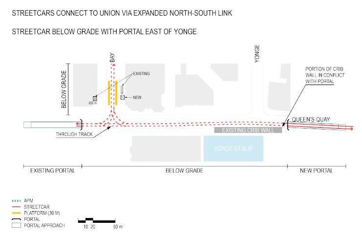
Queens Quay East Portal
In the original design for the Waterfront East LRT, the underground portion extended beyond Yonge Street and surfaced at Freeland, one block to the east. This design was required in part to avoid blocking access to the front of the Westin Harbour Castle Hotel.

A revised proposal shifts the portal to west of Yonge and includes the reorientation of the hotel’s entrance to its east face which now looks out on a parking area and the Yonge Street slip. The slip would be partly filled in to create a new plaza east of the hotel including a drop-off for taxis as well as for buses serving the Island Ferry.

This design is common to both options now under consideration.
Construction and Service Interruption on the Waterfront
The next study phase will consider how the selected option will be built including staging of the work and provision of replacement transit service.
The capacity of Bay Street during construction will be limited to one lane in each direction, and this will have significant effects of spilling traffic onto parallel routes under the rail corridor. At the same time there will be Metrolinx projects in the rail corridor itself, construction of new office towers on Bay, and the reconfiguration of Gardiner Expressway ramps.
Pedestrian volumes around Union Station are very large, and provision for these must be included in the allocation of available sidewalk and road space during construction. Whether any capacity will be left for auto traffic remains to be seen. Transit downtown generally will be affected and Toronto’s notorious laissez-faire attitude to traffic management simply will not do.
A major area in Toronto faces a long interruption of service thanks to the scale of construction needed at Union and Queens Quay stations, and there is no guarantee that work on this key link will get underway soon. The longer we wait, the greater the unmet demand and the effect of a multi-year closure of the Bay Street link on transit access to the waterfront.
Note: The illustrations in this article are excerpts from the presentation slide deck and boards for a public meeting that took place on March 4, 2019. Electronic versions of the full set will be posted on the project’s website soon.

Do they really believe that the people mover option can provide enough capacity in the future to handle traffic growth. It seems to have limited growth potential.
Steve: The claim is that the APM would be able to handle the demand, but thank goodness, that option is fading. The whole “funicular” business that was being pushed by a former CEO at Waterfront Toronto has wasted a lot of time.
LikeLike
To avoid a double transfer, from Union Station to whatever, it is better to expand the streetcar loop at Union Station. Use the same excuse for extending Line 2 past Kennedy.
LikeLike
I wonder if the problems with Union loop would have been easier to solve if the TTC had kept the option of double ended operations with the Flexitys.
Steve: Not much. The problem is the volume of traffic, the need for separate berths for each route and a limit on train length to one 30m car. The station was too small from the outset.
LikeLike
In a beautiful world, opening of rail connection to QQE would coincide with closing Bay Street to motor vehicles from Front Street to the lake. And would have been done in 2016.
LikeLiked by 1 person
If the “streetcar tunnel closed 4-5 years” meant zero streetcar operations east of Spadina Loop, that would seem to me a disastrous outcome. This is a transportation corridor deeming of a hugely expensive rebuild but we can live without it for the better part of a decade? (We know it’s not gonna be four years and more likely to be six or more – you only need to look next door at Union Station)
The necessity to dig down four feet at the Loop does not strike me as simple in a tunnel system already subject to issues of water ingress. Does this issue apply to Queens Quay Station also, since presumably the changes contemplated trigger similar loss of grandfathering?
While some closure is obviously inevitable, that could be mitigated by limiting full closure to:
1. the breakthrough of the eastern tunnel,
2. rebuild of the Bay-QQ curve to a delta junction
3. facilitating of the southern pedestrian egress if agreed with the Westin and such other operations in the Queens Quay Station rebuild as are sufficiently proximate as to rule out concurrent operations west-east.
Once those are achieved, service could run through to a loop (wasn’t land acquired at Parliament Street?) even if full connection with Cherry cannot be achieved by then.
Infill of the Yonge slip is apparently already an unfunded phase of the Ferry Terminal Redevelopment also – (see “Feature 6” here). However, this infill does not show up in other Waterfront Toronto documents like the Lower Yonge Precinct Plan.
If the slip infill facilitated a layover/loop for 97 and 75, along with a secondary exit/entrance to the Ferry Dock, it might justify being accelerated even if Waterfront Toronto doesn’t have the cash right now to fund consultants to decide on the prettiest shrubs to decorate the bit outside the hotel.
Steve: Yes, I agree that staging the work so that the eastern leg is built first and streetcar service can be maintained on Queens Quay for as much time as possible would be ideal. I didn’t get into that sort of thing in the article because the staging study is a whole separate step. That said, a few comforting words from the project team about limiting the length of a shutdown, and hence the project’s acceptability, would be useful.
LikeLike
This is only tangentially related, but it made me wonder what if the Bay Street Trolley had been replaced by a streetcar, would it be worth building one today. Or bringing back a Yonge Streetcar (i prefer streetcars over subways over distances like Bloor to Union), and if that’d provide any relief for Line 1.
Steve: Relief for Line 1 must be provided by intercepting riders before they reach Yonge Street with an attractive alternative. Streetcars on Bay or Yonge don’t really qualify in this regard. It is really important to remember that before the subway opened, riders were funnelled into the core area by many routes feeding in radially from further out, not by transferring everyone off of the Bloor car to the Yonge car. The Bay car, for example, originated at St. Clair and Lansdowne. Bathurst ran from St. Clair to King and Church. Services on Church, Sherbourne and Parliament brought peak-only routes into downtown from the east, and the Harbord car meandered from St. Clair and Old Weston Road to Pape and Danforth via many streets crossing Yonge at Dundas.
LikeLike
It’s so monumentally stupid that the loop was never expanded during the multi-year closure for the Queens Quay reconstruction.
Steve: “Monumentally” does not begin to describe the time lost on this project while Toronto warred over who “deserves” a subway.
LikeLiked by 1 person
Clearly, (to me anyway!), they need to keep streetcars running along Queens Quay as long as possible and building the (permanent) track east of Bay first with a loop at Parliament or ?? sounds best. Of course, they would have to shut it down while building the new portal on QQ but they used to build temporary tracks while doing repairs so building a temporary track at that junction really sounds the best idea.
LikeLiked by 1 person
I attended the public information session on the 4th. The “preferred option” they will recommend to council is the streetcar one. The problem remains the same with this project, as with many others in the city – funding for more than the study is non-existent. They are hoping to get some PTIF funds to do this work, but that requires matching funds from the city. And if they do get the go ahead for PTIF, they would probably have to do this as a “one and done” project to meet the time frame requirements of the federal program.
There is supposed to be a council meeting on all of the city’s transit plans to set funding and planning/building priority in the next few weeks – cross your fingers and hold your breath!
LikeLiked by 1 person
Maybe they need to build a temporary above ground solution first to deliver current riders to from the QQ to Union… and then bury all this infrastructure.
LikeLiked by 1 person
Who comes up with this stuff? People who don’t EVER use transit?! Queensway already has a right of way, just priortise it. Leave the Union loop as is and (maybe) build something else completely different somewhere else to prevent disruption. Cross overs are very expensive. If you wanna zig-zag all over the station use buses. But why do they need to cross over everywhere anyways? And look at the walking distances (from union)????
And what about the 90 degree turns along the Queensway ? Is that to speed up transit or traffic??
Steve: The alignment in the Humber Bay has been settled for some time. Where were you? The Queensway right-of-way is going to be extended east to Roncesvalles next year (it was supposed to be this year, but the project is deferred). Dodging down Colbourne Lodge Road to Lake Shore (which will be done on dedicated lanes) allows the line to connect to a new route that bypasses the extremely congested KQR intersection across south Parkdale. It will connect in to the existing system at Dufferin (there are already plans to build a connection along the north side of Exhibition Place between the two loops).
The crossovers allow cars for two routes to get around each other rather than being trapped. There are only two sets. This is not the end of the world.
LikeLike
Those exits to the Union Station retail level and the York Teamway make me wonder if this new loop would become a shortcut from the subway platform to the inside of Union Station. If it is shorter or more convenient, people will use it, and you will wind up with a pile of pedestrian traffic in this loop who have no intentions of using the streetcars, but are there only to pass through, which may cause circulation problems.
Steve: You also need to understand the vertical alignment of the platforms and how the completed Union Station will work. Anyone who is going to/from the north subway platform (University Line) will come up to the mezzanine which will be on the same level as the new Bay Concourse in Union Station, and for them it will be a straight walk across. Passengers using the south subway platform (Yonge Line) could go through the connection to the streetcar platform and then to the railway station, but they will still have to go up a level. By the way, the exits go to the Bay teamway, not the York which is at the other end of the building.
LikeLike
Waterfront LRT is needed but as Munro himself has stated that the DRL is the number one transit need of Toronto and every available dollar should go to the DRL. Once the DRL is up and running, we can build Waterfront LRT in both the east and the west.
Steve: Actually we need the DRL for regional demand and we need the Waterfront line to serve a fast-growing area where the original plan was to have transit before the development, not after.
LikeLike
Is there really any hope of this being built in the next quarter century? And if there is, can Toronto build anything at a reasonable cost?
Between 2010 and 2025:
Waterloo region will have built 19 km of lrt for $0.9bn;
Ottawa will have built 55 km of lrt for $6.7 bn;
Toronto will have built 19 km of lrt for $9.1 bn.
Steve: There is a tiny difference that much of Toronto’s “LRT” is underground. The surface portions of Transit City largely fell victim to anti-streetcar machinations of Rob Ford and the “we deserve a subway” rhetoric.
LikeLiked by 2 people
Does it not strike anyone as rather disappointing that in the 70’s we had the foresight and the will to build a station as complex as St Clair West. Which was genius for its time. The station is a model for an efficient integrated transit node. But yet its 2019 and were actually seriously debating mothballing a high volume transit station and replacing it with untested technology (for Toronto underground) which will be an orphan within the system (sounds familiar).
Steve: The sad story of the Union Station link rests on a combination of factors including an ill-considered attempt to get rid of the portals on Queens Quay, and a Waterfront Toronto CEO who pushed the “funicular” technology as a replacement for the Bay Street tunnel.
LikeLiked by 2 people
As J Graham correctly points out that the problem with this transit project is the same as that with any other transit project i.e. there is no funding. I hope that Canadians will finally elect a transit friendly government in 2019 because if we don’t, then none of this will ever get built.
LikeLiked by 1 person
George, you are wrong.
Money has been figuratively raining down on transit projects over the past fifteen years, and for most of Canada it has been a golden age of transit construction. In addition to the Ontario projects I mentioned above, from 2010 to 2025
Toronto hasn’t been left out, but you have wasted your opportunities and your money.
The Harper government gave you $.5 bn for your Shepard LRT and $.7 bn for your Scarborough subway. You have let the money sit, unspent. What a waste.
When you do spend, you are spendthrift. You build expensive unnecessary bored underground tunnels (TYSSE, Crosstown). Your stations are wasteful palaces, spending millions on beautiful designs instead of on track. Your one stop Scarborough subway will be the most expensive per km in the world, beating out NYC!
Dysfunctional, incapable Toronto has wasted Canada’s best transit construction window of this half century. Don’t blame others for your mistakes.
Steve: The construction in Vancouver is for Skytrain, not for LRT, and the technology proposed for Montreal is closer to Skytrain than to the LRT we see in Edmonton and Calgary.
LikeLike
Thanks for this, and to commenters too. However, I’m perhaps even grumpier than Steve and others about what I see is inferior propositions to sell-out of a larger number of transit users by too limited analysis and that failure of vision, to the point that it needs another reset.
As a starting point, this Reset didn’t go too far back in looking at earlier plans to basically avoid looking at robust transit options like a subway, though yes, a good RoW would be marvellous. The 1993 WWLRT EA was missed: and it wisely pointed out two types of demand: the milk run along the waterfront, and the commuter direct-to-core demand that wants a sub-regional to near-express trip, and I think the numbers, and potential numbers of even drivers nearby would like to have. The pinch point at the base of High Park limits all transport; that would be the logical point to really make quick trips in to the core from, and the WWLRT EA did actually model out the time savings, using a Front St. alignment, which alas, may be too buggered up with buildings now for even a feeble compromise, and what a shame that everyone’s been too swallowed up in the hype about doing transit with the WWLRT to actually read the EA, and say where’s Relief West, which might be the new name to what was essentially proposed in 1957 with a Queen subway to Islington. (Now King might be smarter,; 1985 was Front St./DRL).
Network building is less good, (if we actually do build that bit of Queensway RoW extension on the south side of the tracks) because that option fails to speed up any transit that is trying to use Roncesvalles up to Bloor, thereby missing an option for surface relief up to Bloor, and thus Relief to Bloor. (I’ve favoured Front St. having transit again, yes LRTs likely best, and it is/was possible to have that sub-regional travel, and King is really close, and Front is laden with all sorts of destinations, plus the connections.
Overall demand should be likely split in to two segments – the west demand in to Yonge/Union area, and the east end.
This is important because we also really need to provide that faster transit to have drivers get out of their cars, and how could GO buses uses a RoW from Unioni to the Exhibition? And GO trains also need some relief btw..
Another trouble is having the whole package kinda approved pending maybe resolving a very large and costly headache of intersection with existing transit, to the point that it needs that reset because maybe the choices that lead to Queen’s Quay are Wrong, and robust transit should be on another access, because it’s really Stupid to be digging too much through all that fill land, since everything south of Front is fill land, and supposed to be be parkland, right?
There is a horrible aversion to actually advocating for robust/good transit from Mimico and Parkdale in to the core; why? I get the core councillors are overloaded; but dang it, with all the tax monies extracted from both core areas and newer builds such as Liberty Village, it all should have much much higher consideration and good solution. Moreso, as Mimico is now sprouting quite a few towers, and nope, transhit is not OK, right? And no, it’s not alright to be degrading the GO service from a regoinal service to a milk run either, and one might hope that the GO riders would stand up a bit for the integrity of that service, plus a backup.
With the east segments, why are we coughing up – or doing plans to cough up maybe – when the existing areas like Liberty Village don’t have improvements, though it’s also easy biking in to the core. Or, there’s Eglinton Ave. E LRT; also deserving. And should public funds be spent to prime development or respond to it? And can we accept that there’s “no money’ when the Moronto majority still seems to like squandering some billions on the Gardiner,, which – along with the DVP – might be an excellent place for some transit, though it’d take some out of town consultants to see the possibilities, right?
Pardon length; but here’s a proposition for re-think – what about having a reversible transit or LRT-way from the KQR area in to Dufferin through the badvertising to the Liberty Village area and then to the core? We only are able to do half-measures, maybe, and enough of the daily flow is in, then out, and the vehicles/streetcars could be returned back to start via King and Queen, as they help form a loop..
It’s truly saddening how many new buildings are sprouting EXACTLY where any transit would be easily crossing over the Weston railtracks, where multi-millions were spent in lowering them to let other transit cross over it very easily.
For the east end – what about buses? And I think it was Raymond that suggested a route for a surface rail up to Front and thence to Union, and then back down to Queen’s Quay then east.
With the impending meetings of all the trans*it ideas, it’s so obvious that this current majority of Clowncil will be incapable of getting towards a correct solution on anything, right?
Steve: The idea of a western link from Mimico to downtown is very much the product of local councillors seeking a way to get people, mainly from the Humber Bay area, into the core. The same pressure is behind the proposed Park Lawn GO Station, although the level of service there will not exactly be frequent.
The LRT route dodges around King-Queen-Roncesvalles because that is an extremely congested area. Extending the Queensway right-of-way east to Ronces will have a marginal benefit for the Queen car, but it will do nothing for the queue of traffic that builds up westbound to KQR during peak periods and any time the Gardiner is closed or badly congested.
Liberty Village would benefit from a new service at the south end, although this still depends on the TTC providing a decent level of service on an extended 509 Harbourfront car. Design for the link west to Dufferin Loop is already in progress. As for Waterfront East, that project should have been built by now, and the “transit first” promises around it were, as usual, political window dressing. Recent machinations by Sidewalk Labs have not helped.
I agree about the Gardiner, but barring a major financial crisis at the City, that ship has sailed. Moreover, if finances bring down the Gardiner project, we will be facing a much bigger problem with many other projects including waterfront transit.
LikeLike
Both Ottawa and Toronto’s will be significantly underground. Toronto = 10km, Ottawa =7km. When on the surface, the rest of Ottawa’s is grade-separated, Toronto’s is not. Every other city, including Ottawa, look like a bargain compared to Toronto. It’s hard not to see a Toronto premium in transport construction, approaching NYC’s.
Ottawa may have a DOA system if it can’t perform in winter – Alstom’s Citadis is a real unknown quantity. And truly, the City of Ottawa’s project management looks like amateur hour – until the Toronto political gong show heaves its way into view.
Steve: One must be careful in comparing “underground” construction. Toronto had more difficult ground conditions and some very deep stations due to the hills and valleys along Eglinton, for example.
LikeLike
Ottawa’s LRT underground portion is 2.5 km.
LikeLike
2.5km is only the downtown tunnel that was mined from about 2014-2016.
Stage 2, the contracts for which were recently approved by Council, will grow the O-Train system to 64km of track, 7km of which will be underground. The original poster included stage 2 in the $6.7B cost figure. Stage 1 = $2.1B, Stage 2 = $4.6B, ignoring some rounding errors.
Steve: Just as a note, I updated robt’s comment to include the specific text from the site with the measurements. He had linked only to the intro page.
LikeLike
Two projects are never completely comparable, there are too many variables. The downtown Ottawa tunnel was shallower in the final design but according to geologists I know had the more difficult soil conditions, and that was nicely illustrated by the rather nasty sinkholes it produced. The next 4km of tunneling in Ottawa will be much easier/cheaper than Eglinton.
But to some extent, the difference is not in the terrain, but the contracts. The City of Ottawa isolated itself from what have turned out to be about $500M of construction cost overruns, and TTC/Metrolinx didn’t fare as well TYSSE and Crosstown, at least in the short term. There were and are other negative consequences to Ottawa’s approach, but Ottawa prioritized construction cost containment, and didn’t have a meddling Council and Queen’s Park to drive up uncertainty.
Steve: A related issue is the degree to which bidders strong-arm agencies to avoid too much risk transfer which they then build into their pricing. Metrolinx talks a good line about risk transfer, but also doesn’t want to pay a lot for, in effect, insurance they might not need.
LikeLike
This is an excellent point and one I haven’t seen raised in any media I’ve seen to date, at least in Ontario. It was discussed a bit in some french media regarding REM, but buried in that project’s other, more glaring issues.
But overall, it’s a point not well understood by the public and their representatives, and it’s yet another transparency complication inherent in the P3 process.
Notably, Ottawa’s determination to transfer risk in stage 1 led to some surprises in the pricing it was able to get for stage 2. P3 Consortia have become more wary than ever about how much risk they’re taking on. As they do so, the value proposition of the P3 approach diminishes.
The one thing I will say about a P3 for Ottawa’s stage 2 is that it avoids later Council meddling – Ottawa will largely complete its BRT->LRT conversion about as fast as possible in the Canadian context.
LikeLike