
The first of two public meetings on the City of Toronto’s so-called “reset” of transit plans for the waterfront was held on May 25, and a second is to follow tonight (May 26).
The presentation deck from these meetings is now available online.
Updated May 27, 2016 at 5:30 pm: The preliminary evaluation grids for various routing options have been added to this article following the original discussion of each section of the study. This raises an obvious question of how options can be scored before important factors such as demand projections, design and costing are known, and whether the preliminary scores will bias the discussion and evaluations to occur in Phase 2 of the study. Scroll down to the end of each section for the additional material. (Apologies for the resolution. The grids are not available online, and I am limited by the quality of the paper copies distributed at the meeting.)
There is a lot of material to digest here, and the process is not helped by several factors:
- Council has imposed a very short timeframe, considerably less than would normally be taken for the scope of work.
- All proposals that have ever been on the table for the past few decades and a few new schemes are up for discussion, including some that should have been discarded quite early in the process. In part this is due to the many incomplete studies of various sections of the route that never got to the point of killing off the unworkable options.
- The City and consultant staff presenting this material are not intimately familiar with the details of many proposals, nor with the history of how they came to be part of past studies.
- Conflicting goals of previous studies, not to mention of today’s Councillors and community groups, make a “one size fits all” solution impossible.
- Beyond identifying a few locations where GO/Metrolinx might add stations in the Lake Shore corridor, there is little discussion of the role GO/RER can and, equally importantly, cannot play in handling travel.
- There is very limited origin-destination or demand information with which to validate or compare proposals, or to put them in the wider context of competing demands for transit funding.
- A vital consideration for any network is the effect on travel times. After spending millions (or even billions), how would the speed and capacity of travel have improved?
- The real meat of any discussion remains for an as-yet unapproved “Phase 2” study that would include [text taken from the presentation]:
- Feasibility studies (including but not limited to demand forecasting, operational assessments, further developed cost estimates);
- Potential Environmental Assessment(s) or amendments to existing Environmental Assessment(s);
- Pursuing the implementation of short term strategic improvements that minimize long term throwaway costs; and
- Advancing a Business Case and pursue funding opportunities.
As someone who has worked for years in hopes of better transit service to the waterfront, all of this is quite disheartening. So many competing ideas are on the table, so many competing priorities, and so little desire to spend pervades the discussion. We may end up with nothing at all.
Growth in the Waterfront
The need for better transit to many parts of the waterfront is quite obvious to anyone who looks at the forests of new condo towers along the water and neighbourhood close by to the north. Much of the projected population growth in Toronto is located in the southern part of the city (an area considerably bigger than the traditional “downtown”), but transit improvements there always come second (at best) to proposed expansion elsewhere. Where suburban subway boosters take a “build it and they will come” approach to subway advocacy and treat rapid transit as a trigger that will, they hope, bring new population and jobs, the waterfront already has both, and is growing apace without adequate transit support. Improved transit to the eastern and western waterfront rank in the top five performers of the City’s “Feeling Congested” study.


This growth will not all arrive “tomorrow”, but it certainly will build in over coming decades. Already, access by transit across the waterfront is inadequate, and this will only get worse as time goes on.
Subdividing the Study Area
The study is broken into four segments to bring the permutations among the options down to a manageable number. This is laudable, although what can be lost is the dependencies between goals for one section with those of another.

The overall scope from Long Branch to Woodbine and north from the lake to Queen was set by Council’s terms of reference. At the May 25 meeting, a few in the audience complained that Scarborough was not part of the study. They should take this up with their Councillors, but equally this belongs in a general review of Scarborough’s transit, not just the waterfront. This is touched on but not really explored for options within section 04 that would link the eastern part of the streetcar network into a new LRT route through the Port Lands into the core.
Long Branch to Humber
The existing area contains diverse travel demands, many of which are not oriented to downtown. (Note that the skew in maps here is in the originals.)

An important issue in southern Etobicoke is that there is a great deal of “local” demand for travel within the area, or at least to locales that do not require coming east of the Humber River. At Kipling and Lake Shore, Humber College is a new major destination, and development will continue further north (some beyond the study area such as the Six Points).
The streetcar service on Lake Shore might, or might not, be upgraded to “LRT” although exactly what this would mean is up for debate. The worst of traffic congestion occurs at the east end of the line, and it is not clear that a private right-of-way and, possibly, the loss of some local stops would benefit transit quality further west. For one section of the route, through Mimico, the road is too narrow to allow conversion to “LRT” in the style of Spadina or St. Clair.
GO stations are mentioned here as a possibility, but there are a few obvious problems:
- Without attractive fares, people will not use them unless convenience overwhelms cost.
- Station locations well north of Lake Shore cannot be accessed directly except for riders on the north-south bus routes serving them.
- GO will not stop at such closely-spaced points, certainly not for its long-haul trains to Hamilton and beyond that will remain as diesel operations.
- There is a basic question about service capacity both on present and future infrastructure.
The outer part of the Waterfront West LRT scheme has always been the most challenging in terms of the area it will serve, and the nature of demand along the Lake Shore. This is something of a chicken-and-egg problem because streetcar service to downtown has not been reliable or attractive for decades, and this route becomes a choice of last resort. How much this might change depends not just on improved frequency and speed of service on Lake Shore itself, but on what happens on the long trek to downtown for which options and choices in other segments are vital.
Three options are considered:

This amounts to little more than some sort of improved streetcar service, but without a full conversion to an “LRT” right-of-way.

Lake Shore would be upgraded with a full right-of-way treatment. This runs into problems at the narrow section in Mimico, and the question of whether it is actually needed on the wider part of Lake Shore further west.

This concept responds to proposals for an LRT line on The Queensway. What is not clear is whether the demand that might originate there is (a) sufficient to warrant an LRT line or (b) actually oriented to downtown as opposed to points north and west, or to midtown locations via the Bloor subway. The Queensway LRT option has been dropped from further study because it is remote from the waterfront itself and does not address demand in the Lake Shore corridor.
Update: Preliminary Evaluation

Both options on Lake Shore score “Very Good”, although that’s a bit of a stretch considering that both 1A and 1B have different scores on several aspects. The Queensway option 1C scores lower both because it is remote from Lake Shore, and because its cost is higher as a new line rather than an upgrade to existing infrastructure. What is not clear in this or any other evaluations is the weight given to each component, or the degree to which the same external effect (e.g. close to the water) counts multiple times under different criteria.
Humber to Strachan
This segment presents two types of problems in that it has the characteristics both of a “bridge” between two origin-destination areas, but it also might be called on to provide local service to neighbourhoods along the route. Much depends on the chosen alignment, and all of the desired services and links cannot be provided by a single route:
- Liberty Village is a fast-growing area north of Exhibition Place now served primarily by the King streetcar, although the area is building out north to Queen and will tax that route as well. Aside from service capacity, a major problem is physical access from the residential area north of the rail corridor to potential new services further south.
- Although outside of this segment, the condo developments from Fort York eastward might or might not be served by any new through route coming east through the Exhibition grounds.
- Proposed development on Lake Shore near and within the Ontario Place site is remote from any service along the existing streetcar network or a westerly extension beside the rail corridor.
- Service to South Parkdale including a connection to existing service on Roncesvalles will be difficult or impossible for some of the proposed alignments.
- Any service passing through Exhibition Place must be immune from seasonal and special events in the grounds. It is pointless to advertise a “rapid transit” service to southern Etobicoke if it shuts down every time there is a game at BMO field, or the grounds are taken over for the CNE or a racing event.
- Potential GO sites are shown below at Sunnyside and Parkdale/Liberty Village. GO has already criticized both of these as difficult if not impossible for their trains due to space constraints and platform curvature.

Six proposals for this area attempt to thread from a common origin at Humber.

This concept’s name “Complete the Missing Link” is a political one originating with a Councillor for southern Etobicoke. Its premise is to link into the existing Exhibition Loop after travelling south of the Gardiner along Lake Shore between Sunnyside and Dufferin. The existing Queensway right-of-way from Humber eastward would be used, but it is unclear how the route would fly over or under the rail corridor and Gardiner Expressway to reach Lake Shore Boulevard. Note that the transition occurs west of Roncesvalles roughly at the lowest point of the Queensway trackage relative to the other corridors. (A transition at Roncesvalles itself is not practical because of the intersection’s complexity and existing levels of road and transit traffic.)
This and other schemes linking directly to Exhibition Loop raise the question of how the existing access to GO Transit’s station (immediately west of the streetcar loop) would be handled if the streetcar trackage is extended further west.

A route north of the rail corridor would branch off somewhere around Roncesvalles and be sandwiched between GO Transit and the south end of properties to the north. It would arrive at Exhibition Loop on the “wrong” side of the rail corridor to connect with the existing infrastructure.
This option has been dropped from study because it has severe effects on properties in south Parkdale along the north edge of the rail corridor. It also would have a more difficult connection right at Roncesvalles rather than further west clear of traffic and other streetcar routes.

In concepts 2C and 2D, the LRT line does not enter Humber Loop, but stays on Lake Shore from that point eastward. In one option (2C above) it swings south of the Exhibition passing by Ontario Place, while in the other (2D below) it follows the same path as 2A along the north side of the Ex. These options have the advantage of avoiding the King/Queen/Roncesvalles area and the general problem of crossing the rail corridor, but they are very much express routes from the Humber to Strachan serving little in between. North-south access would be possible, but it would not be a simple or short link in many places. The route along the south side is remote from much of the population in south Parkdale and Liberty Village.


Another variation on the Lake Shore routing is to stay with the right-of-way on The Queensway as far east as Colborne Lodge Road and then swing south to Lake Shore.

Finally, with Concept 2F, the “LRT” stays entirely on the existing streetcar system via The Queensway, King Street and Dufferin Street. This is a difficult option considering the level of service already operating on King and through the Roncesvalles intersection, not to mention road congestion in the area. This option would almost certainly have the slowest travel time of all, and though cheaper, might not be very attractive to potential riders. There is not much point of improving an “LRT” in Etobicoke only to have it morph into an ordinary streetcar line in Parkdale.
Update: Preliminary Evaluation

The two lowest ranked options (“Fair”) are 2B (North of Rail Corridor) and 2C (Lake Shore LRT), although for different reasons. Everything else comes out with a “Good” although various components contribute to this.
A good example of the inconsistencies in this process can be seen in 2F (Dufferin/King) which ranks low on speed and capacity, but high on cost because it is cheapest. Without an actual demand projection (a process that itself will produce variable outputs depending on the network configuration), we do not know whether there is a screenline below which some options simply do not work. A “very good” construction cost may not represent good value for the task at hand, but that’s not part of the evaluation.
Strachan to Parliament
The downtown segment has many options including four routes from Strachan to Bay, and various schemes for dealing with Union Station. All of the approaches from the west have problems, and there is no clear, simple path to Union Station.
This is a point where the planners’ stance gets a bit complicated. On one hand, they say that for the eastern waterfront, they are using the already completed (and approved) Environmental Assessment for the LRT line, but on the other hand, the access to Union Station is up for major redesign to the point where very little of the “approved” LRT remains. The presentation dwelt on the cost of linking in both at Union, and further east at Parliament/Cherry, even though this was less of an issue further west, and certainly does not inform major proposals elsewhere in the network.
To put it another way, there appears to be a bias against certain configurations before we have even worked out which of them works best as a transit scheme. This is particularly evident in comments about Union Station (see the next section of this article for details).

Unlike the options further west, the concepts here link with specific alignments to either side. What might be a “preferred” or “better” option seen in isolation might not work well with the chosen plans to the east or west.

Using the existing Fleet Street route (an area that was specifically improved in anticipation of the WWLRT) implies that the line further west would come into the north side of the Ex south of the rail corridor to the existing loop. Fleet presents issues at Bathurst because of the need for all service to swing south across Lake Shore (which gets a lot of green time while transit awaits its cycle), and because of the comparatively slow journey into Union via the 509 route.

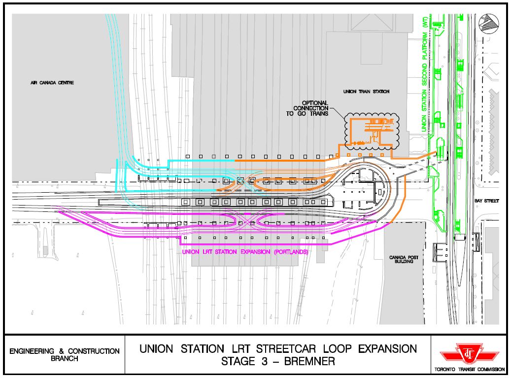
The “Bremner streetcar” has been around for a long time in TTC plans, but it has several major problems:
- The proposed route north via Fort York Boulevard from Fleet Street potentially conflicts with activity at Fort York itself as well as the future “Under Gardiner” project.
- There is no provision for a transit right-of-way on Fort York Boulevard west of Bathurst.
- There is no provision for a transit right-of-way on Fort York/Bremner east of Spadina, an area noted for severe congestion and large crowds of pedestrians around the stadium.
Over the years, it has been fascinating to see this line show up repeatedly on maps giving the impression that no planner has ever been south of Front Street. During the presentation, mention was made by the consultant that a tunnel approach might be needed, and I suspect that the tunnel grows further west every time the idea is reviewed. However, existing underground structures south of the Convention Centre could well block this option.

An alignment north of the rail corridor would pick up the new street planned for the south end of Liberty Village. However, this really only works if the corresponding option 2b is selected, and it has been dropped.
Also, this would leave the line “dangling” at Bathurst Street where it would face a very congested Front Street that is designed for motor traffic, not transit.
The presentation included a bizarre comment about how a Front Street alignment might serve a future GO station on the Bathurst Yard lands. It is unclear how what would essentially be a streetcar line would handle the effect of 2,000 at a time peak loads alighting from GO Trains. Moreover, just like GO, an LRT/streetcar originating in southern Etobicoke and serving Liberty Village would be full by the time it arrived at Spadina.
Finally, there is a tiny problem with Front Street at Union Station where the street has been substantially pedestrianized.
This whole idea is badly thought out, and should have been struck in Phase 1 of the study, but it survives.

Finally we come to the continuation of a Lake Shore alignment. This, like concept 3A, connects to the Queens Quay trackage shared with 509 Harbourfront and thence to Union, but it would connect at Bathurst/Lake Shore in a different manner, further to the south.
Update: Preliminary Evaluation

Only the “North of Rail Corridor” option 3C ranks as “Fair” with all others as “Good”.
The Union Station Conundrum
Four sets of options are presented to deal with capacity issues at Union Loop:
- Modify the loop
- Build a second loop specifically for the new western LRT
- Through-route service on Queens Quay east and west
- Redistribute access to the waterfront
Before going into the details, it is important to remember how we got into this mess in the first place. When the TTC designed Union Loop, they grossly overestimated its capacity at the time including:
- No provision was made for the platform space lost to car swingout on the very tight curve.
- The full capacity of the passageway between the subway and loop was assumed to be available for unidirectional flow when, in practice, half of the space is consumed for queued passengers.
Here is the loop as originally designed.

The loop is constrained to the east and west by the Customs House building and Union Station respectively. The passageway to the north now terminates on the new northbound-to-Yonge platform of the subway station which is at the south side of Front Street.
The last time a design for an expanded loop was published was back in 2009 before the arrival of Mayor Ford stopped all work on waterfront transit in its tracks.
Even this design is not current because a link is planned to a new building on the east side of Bay that will contain the new GO bus terminal. A spur structure is shown in the drawing above, but it is unclear what platform area it would link with, particularly for riders wishing to ride south on the streetcar/LRT services.
The optional link into the railway station has not been built, of course, because this expansion project which could have been undertaken concurrently with other work at the railway station and on Queens Quay just sat on the shelf.
This is still a tight layout especially if three separate services would operate here and the whole thing would require much more capacity simply for pedestrian circulation.
Now let’s look at the options that the “reset” is contemplating. Take a deep breath – truckloads of crayons gave their lives to bring you these designs.

A.1 is the scheme shown in the TTC drawing above and includes the new junction to the eastern waterfront line at Queens Quay. This was the state of design as of about 2010. As mentioned earlier, there are serious question to be asked about the loop’s capacity, and one alternative scheme was to extend a new tunnel east under the rail corridor presumably through the substructure of the rail viaduct to a point east of Yonge and then south to Queens Quay.

This would avoid the creation of a junction or the need for streetcars to turn around at Union. One issue to be resolved would be access across the tracks between the subway station and the north/eastbound platform for the streetcars.
The planners are not much enamoured of this scheme because it requires a tunnel and would be expensive. Also, operationally, this scheme would require all service arriving at Union to continue east to wherever the first turnback will be built on Queens Quay (likely east of Parliament). This creates a link between the eastern and western services that could be hard to manage (think of the Queen car and its through service to Long Branch).
For reference, the original scheme A.1 above would have emerged onto Queens Quay just west of Freeland Street.

The second loop scheme would require an underground loop somewhere west of the Air Canada Centre. This will be challenging considering that the space is already occupied by the Convention Centre. Moreover, the walking link to Union would be fairly long and riders from the west might rightly ask if this is how they will be expected to access the subway and core area. (I think here of Scarborough riders who complain about the Kennedy Station SRT transfer which, compared to this, is short and sweet.)

In scheme C.1 service from the west (or at least some of it) does not enter Union Loop but continues through to Queens Quay east. No service design has been proposed, and in any event this does not address the additional demand that riders bound for the eastern waterfront will place on Union Loop.


Now things get really blue sky, although for a tunnel that is probably not the appropriate metaphor. The existing Bay Street tunnels would be converted into pedestrian and cycling links from Front Street to Queens Quay (how the cyclists would get in and out has not been explained).
A few points are worth noting here:
- Such a link would impose a 500m walk (about the length of three subway stations) on the connection from Queens Quay to the core. This will very substantially add to travel times.
- A long walk is an accessibility issue, especially if the walkway is not functioning, a not uncommon situation for TTC infrastructure of this nature.
- The existing link to the Island Airport is slightly less than 1/3 of the length of the Bay Street tunnel.
- The example shown above from Amsterdam is a mere 110m long.
In other words, we would rip out the direct link from Union Station to the waterfront that so changed access to this area a quarter-century ago because we don’t want to expand capacity at the loop.

The street level bypass would provide a combination of street trackage for through service to Queens Quay east and access via the existing tunnel to Union. This would consume a great deal of space at the already busy Queens Quay/Bay intersection which has just been redesigned. This option is a non-starter and has been dropped.

In this scheme, the existing tunnel access on Queens Quay disappears, and all service runs through to Queens Quay East. The idea that the demand between Union and the Queens Quay service would be provided by an “enhanced” Bay bus service is laughable given the usual state of traffic in this area, and the need for thousands of passengers to transfer on street. Again, the travel time, all in, for trips to/from Bay and Front would be substantially longer thanks to this arrangement.
Its purpose, by the way, is to get rid of the tunnel portal and thereby beautify Queens Quay, a project which recently completed at great public cost.

An on street loop around downtown would add to the existing service on King the very substantial traffic of streetcars serving the waterfront. Again, there is an absence of basic analysis of traffic and passenger volumes, not to mention travel time, that should knock this scheme off of the table.


Even more fanciful is an LRT extension up Bay Street. The idea that Bay Street actually has room for a new streetcar service either at grade or underground (where it would run smack into many services including the existing subway) is one of those proposals that make seasoned transit activists like me weep. This is so far away from any version of “reasonable” that I have to ask whether a pot dispensary has opened near the project office.
Parliament to Woodbine

The western part of this segment contains the already-approved waterfront east line including:
- A link north under the rail corridor to the new trackage on Cherry Street
- A link east via Commissioners to Leslie and trackage serving Leslie Barns
- A link north via an extended Broadview Avenue to Queen and thence north to Broadview Station
- A link south to Cherry at the Ship Channel
The matter of the link from Queens Quay to Cherry came up in the May 25 session, but the presenters didn’t know much about it beyond that it might be expensive. This is an odd statement considering that the detailed layout for New Cherry Street is part of the EBF transit scheme, and the link shows up in drawings of the revamped Gardiner Expressway. Indeed, the reason the new track on Cherry is on the east side of the street is so that it will easily hook up with the south-side trackage on Queens Quay once that is built.
As for links to the east, it is unclear why an “LRT” paralleling Queen beyond what is already planned for Commissioners is needed as the section between Leslie and Woodbine does not see much congestion. There is again the question of the comparative travel times for riders bound to the core via Queen Street as opposed to the more roundabout route through the waterfront, especially if a direct service into Union Station is cut as proposed above.
Two schemes for an eastern link are proposed, one via Lake Shore and one via Eastern. The link via Lake Shore connects at Woodbine, and therefore could not be used for a Kingston Road service to downtown unless it was extended north. Lake Shore itself is quite busy and attempts to shift the carhouse access to any route that would have installed track there were rebuffed strongly by the TTC and the City.

The Eastern corridor would link to the south and of Russell Carhouse (another Leslie Barns access option the TTC and City rejected), and thence to Kingston Road. Whether this would be any benefit to riders from the Beach or from Kingston Road is quite another matter.

Update: Preliminary Evaluation


I saw 4418 being chartered this afternoon. Why is the TTC complaining about new streetcar shortage when they have enough spare ones to charter during a very busy summer weekend afternoon with beautiful weather and Doors Open Toronto, etc? I hope that the TTC will release this information in court proceedings against Bombardier for the alleged delay in new streetcar delivery. Meanwhile the 501 Humber showed up half an hour later and not even an old-articulated one but a non-articulated one and heavily crowded. How is this fair? The TTC happily provides private chartered transit but claims monopoly rights when private vehicles provide public transit. TTC like any corporation only sees money and will do anything to make money including suing Bombardier for new streetcar shortage when they have plenty of spare ones to charter, suing private players providing public transit when TTC itself happily sacrifices public transit quality/service to provide private transit to make more profit., etc.
Steve: I am not sure what this is doing in a thread about the waterfront planning, but I will promote it on spec with the hope that this does not turn into a pitched battle of gripe sessions. Please stay on topic folks, or at least look for an article related to what you’re writing about.
Also, please be intelligent enough not to leave multiple comments under different user names all originating from the same network address in quick succession. That’s one hallmark of a troll, and a good way to encourage me to delete them.
LikeLike
I’m going to be brief tonight; starting with appreciation for Steve for doing this, and his restraint in condemnings. It is such a Foul to have the obvious corridor for a century (base of High Park to core) have a plan maybe every couple of decades, and nothing, and meanwhile, a fairly spurious new idea of a Scarborough subway extension sabotages good planning, gets tax hike funding though it’s a local project and in this obvious transit corridor (where at least the province in GO has been pretty smart/useful), we have a Hurry up!! we need to make more mistakes no time deadline, and let’s not get into old details very much either; too much time and time is money.
We could use some roadicalism too – why no busway on Gardiner or Lakeshore concepts?
I’ll try to be more reasoned tomorrow; and no wonder we’ve got is it RECORD heat? for May? after a non-winter…
LikeLike
Hope is slowly returning for the return of the Waterfront West LRT. 501 just isn’t adequate. To get downtown from Lakeshore/Mimico area, you’re doomed to either take a slow streetcar (especially when it hits Queen/Roncesvalles), taking a streetcar in the wrong direction in order to get onto the GO train… or take one of the buses up to Subway Line 2. Also… they really do need to fix the service available on the Queensway. That is a disaster itself… and there’s more condos going up.
LikeLike
Should they build any kind of western Lake Shore LRT, between the Humber River and Roncesvalles, they’ll need to return the old 138 South Kingsway bus route, or a reasonable facsimile thereof, from the Jane Station south to The Queensway.
Doesn’t have to be a resurrected 138, but could be a southern extension of either the 55 Warren Park or 26 Dupont. Or run the 195 Jane Express directly to The Queensway, with no stops except at Morningside Avenue and at The Queensway & Windermere Avenue.
LikeLike
I recognize that there are many viewpoints and constraints on ideas/service – including money. But heck, why are we squandering the billions in Scarborough and failing to provide a strong budget, or possible budget, for a transit corridor obvious for a century? And hurry up and make comments known (do more work for free) in a week, because the Clowncil has to make more mistakes as we have to build transit, and who paid for that $75M switch away from the LRTs in Scarborough anyways?.
The 1993 WWLRT EA is actually good/useful reading on this topic of east-west transit, and it divides it into two rough groups: milk-run service near the lake, and a faster east-west into the core service from Etobicoke/Parkdale (and now Liberty) areas. The existing service hasn’t been too good for a while, and so there are definitely some who go up to Bloor for the subway and its speed/reliability – so this is also a Bloor subway relief issue ahem, and we MUST be thinking of high-quality/faster transit and not have our sights/ideas remain lowered from the era of Ford and the thoughts that anything has to be better than zilch.
Faster transit with fewer stops would also help King/Queen services, and might tempt some out of their cars as well. And there is a basic pinch point at the base of High Park that ALL of the traffic/people who are wanting to come in to the core of the City have to get through – so it is truly a very natural transit corridor.
And yet it’s as if we have the oil, gas and car companies planning and doing our transit so bad has it been on the City level, but true thanks to GO and the province for immense transit – tho at least the railtrack corridor was extant.
If we had political will, we could likely do a busway on the Lakeshore really quickly, Or on the Gardiner – and share it with GO buses too, GO being the lever that might be most useful to spike the hurry up and make more mistakes path as we do need a TTC RofW to solve the Etobicoke/Parkdale/Liberty problems, and why not share with GO??
Those are obvious options, but not official, because we’re Caronto the Carrupt, tho maybe it should be simply Moronto. And it’s fascinating to see the gyrations of many elected on this – because we haven’t done transit, a piecemealed remnant of a Front St. local road folly is now up to Clowncil for an EA approval, yet this same stretch of lane could be a very integral key link to the core, if we thought transit ie. from Dufferin to Strachan, and then across lowered rail tracks to get to Front St. Both local Councillors Perks and Layton are very gung ho for the road, and have forgotten that there are OPs, and Places to Grow, and transit-first things that in theory mean we should do transit, just we need to do things, it’s soo desperate, and they’re not talking about the climate.
So I’m still keen on having a more robust extension of the Queensway RofW get to Queen and Dufferin somehow – and then kick in along a new alignment on land just north of the tracks and finally buying out Dominelli and is it Martin? to Strachan-ish, cross lowered tracks, and then in on Front, ideally in a RofW, but Moronto didn’t think transit though the precedent is very clear in the 1985 Downtown Rapid Transit Study on 1/15 of the 1993 WWLRT EA. Put in 3 stops at Liberty Village – one at Dufferin, one opposite GO, and another at Strachan area as yes, the area is now isolated, and take some blame province via OMB, and how about a large-scale development freeze till we actually get some real relief.
There’s a further option which is ignored in this, and by other officials in that the north side of the Weston rail track corridor between Dufferin and Bathurst is diagonal, and follows the shore outline, and it is now being expanded, or will be, made waaaay easier with the Packing plant now exited, and not yet sprouted to that 50-story tower likely coming in some minds/plans. It would be very foolish to let only GO have access to the land, and we should ensure – somehow – that the TTC gets in there to stake out the turf, but they are also in such a stinking bad mess of politics that ‘planning’ isn’t there; only scheming, and suburban agendas. If we had the streetcars able to use even ONE lane worth in the rush hours for an expedited quick trip in to Front/Bathurst (and yes, then new streetcar tracks on Front St.), that would be far better than nothing, and would be offering considerable transit relief to the areas/people.
As I’m sure there are going to be a few who say nope, can’t happen for lots of good reasons, then it’s time to think buses (again), and have busways, reversible if needed, but still in and out of the core in a sub-regional not-stopping often service for that speed that’s needed to make the service really really appealing.
Everyone but the citizens and advocates should be given a LOT of heat about all of this, and I’d start with the Hurry up and be consulted so we can make more mistakes ‘deadline’. It’s only been a century; and I’m sure all of us want faster transit built, but they’re cheaping out and also cramming things in to fastbake inferior options that will arrive as a lump of things that aren’t funded, except for the stupidest.
How did Mr. Grimes vote for Scarborough follies? Why should the province be let off the hook and let more mistakes be done? Why can’t we have a demonstration of integrated planning AND PERFORMANCE but having GO buses be given a transitway too, say from Dufferin in to the Bay St. terminal via Front St., and yes, maybe a new bridge or two (or ramp) accessing either the Gardiner or the Lakeshore.
One final point: 2b has apparently been cut due to concerns about impact on housing – but there is a fracking railway corridor and too many lanes of asphyxiating excessway RIGHT there, and if it really is about the housing, and not about losing the ad revenue, or the ads, then yes, build out over/above the rail corridor (they own the embankment/ads), and have the transit run atop it. It’s got to be relatively simple engineering and construction, though of course it would cost money, and will they say we don’t have money?? Let’s kill Scarborough, though it’s good noting that the long new proposal is about the same length as Parkdale to the core, so why not put in a subway tunnel in the core, where there are tens of thousands of REAL users awaiting better service?
This has been far too long as a ‘comment’ – but there are about 3/4 other options that are not seen, because it’s a complex file/area (in some ways), and it really does seem that our city is run by the oil, gas and car companies as this is most obvious corridor for improving transit we have, at least to me.
Thanks
LikeLike
It reminds me of Milton Keynes (UK), where the Redways (segregated bike path network) is known as the Rapeways due to the poorly designed underpasses. Can you imagine the problems with snow, salt, and ice?
A large part of the Metrolinx study is what I call “coffin nails”. While you can fix almost any problem if you throw enough money at it, Liberty Village is one of those stations that just doesn’t make technical sense unless you’re willing to do something radical. You have 8 tracks in a depressed rail corridor that’s already so tight they put fibre optics on the wall because there was no space in their traditional location next to the tracks. If you were willing to expropriate 5-8m of land on both sides and willing to redo the whole Strachan Grade Separation project, you could squeeze in two side platforms. However, the vertical profile would either impact King or Strachan or be non-standard for its slope. Operationally, it’s not great putting a station at the bottom of a valley.
I don’t know anything special, but I can look at the same constraining factors and decision criteria. The X-factor is the behind-the-scenes politics that will taint the recommendations. I’ll write up a list of the stations and their primary raison d’être or n’être pas, but it’s all a bit off topic for this thread.
Steve: It’s off topic only to the degree it wanders away from the Lake Shore corridors. These issues affect not just GO, but also Smart Track in case anyone has hopes that some local service with more stops can be implemented on top of the GO operations.
LikeLike
I’m not as cynical about including the more “imaginative” proposal alternatives. Its an easy way of saying “we’ve already considered this proposal” if some genius comes along bringing up the idea.
Steve: I would agree with you if there had been better commentary on the evaluations, and a sense that the people presenting the work to date actually understood the history behind some of the schemes. If too many options are left open, uncritically, they could raise expectations of actually being selected.
LikeLike
Gaaaaah….. build the line proposed under Mayor Miller, buy some double-ended cars, run most of the line straight though end to end and use only the Spadina cars on the loop.
Problem solved, OK?
Just spend the money on it… I am also not optimistic that they will do anything given the number of half-finished studies over the decades.
LikeLike
Someone should make a map for all the potential purchasers of new homes or investment condos in the eastern waterfront of all the buildings that have been built in Toronto and marketed on speculation that a subway or lrt was right around the corner and never arrived. Transit plans in this city only serve to increase sale prices for developers and disappoint those dumb enough to believe them. One might almost think there is some collusion going on between our elected officials and developers, with both knowing that there will never be shovels in the ground, just the appearance of movement until all the units are sold.
Steve: Actually the bigger issue in East Bayfront is with commercial development. Potential builders find that companies do not want to locate somewhere that will be difficulty for employees to reach by transit. Developers are now pressing the City to make good on its promised LRT investment, but of course that is hostage, like so much, to the combined effects of the suburbs vs downtown split, and the Mayor’s indecision on spending transit dollars.
LikeLike
@Nathanael: Seconded!
This entire “reset” is a lot of nonsense mixed with a few glimmers of hope.
Convert the Bay St. tunnel to a “bikeway”??? Has whoever is in charge of this been taking a few hits from Rob Ford’s pipe? Finally, the legions of Toronto cyclists dreaming of cycling through a dimly lit former streetcar tunnel straight onto the subway platform at Union will get their shot to do so! Or wait, maybe they’ll just keep biking on the surface of York/Bay Sts where you know, it actually makes sense.
But more seriously … apart from looking like a crayon fetishist’s wet dream, option 2A for the Union loop looks like it would cost about a billion dollars extra while just making things more circuitous than needed. Yes Union is a problem, but the spaghetti lines on those maps above are a Gordian Knot that requires some lateral thinking to disentangle. And why shouldn’t the solution be Nathanael’s idea above?
Yes it presents some increased organizational complexity for system operation and decreases capacity of vehicles somewhat. Yes we just bought a whole bunch of single-ended trams which are arriving someday. Maybe. But the Bombardier LRVs that the TTC streetcars are based on are designed to be double ended with doors on both sides – can it be that hard for them to go back to something that’s MORE like their base model? If I was the city I’d tell Bombardier we’d agree not to sue their ass for being so late in exchange for making a modification to our order … if it meant saving a ton of money on a complex loop re-design. The double-ended streetcars could just be the last to be delivered, giving the company more lead time as the existing loop would have to undergo some modifications anyway and wouldn’t be ready for them immediately.
Steve, thoughts?
Steve: From a purely manufacturing point of view, double-ended cars are a big change because it’s not just a case of putting a cab on the other end, but doors on both sides. The interior layout including provision for wheelchairs and cyclists depends on having the “closed side” available in the vestibules. The cars would become more like the Metrolinx cars which will be double ended, but with necessary TTC mods for curves and grades.
As for the station, the problem is that we would need several stub end tracks each with a capacity of an LRV and with a platform space. I would say three at a minimum, probably four, although the approach tracks (crossovers etc) get complex at four. I don’t think there is room between the north edge of the existing loop and the beginning of the rail viaduct columns to fit all of that in. It is probably simpler to stay with the TTC’s plan at least for track layout, but it needs work on capacity of the access paths to the platforms.
LikeLike
I found some of the old presentations from the Waterfront West Streetcar on Gord Perk’s site.
I always favored the north of rail corridor option. It would be the fastest, shortest and close to Parkdale. I thought the effect on properties was that some backyard sheds that had been built what is in fact railway owned land would have to be removed.
I’m not sure why it would be more expensive as the most of the other options involve new bridges or more new track.
LikeLike
I asked a spokesperson/consultant about exactly that at the public consultation, wondering why they would reject that route option at such an early stage given the same potential benefit you mention. He told me that they would have to expropriate backyards and that was considered a last resort.
Steve: There are locations where there is very little room between the rail corridor and properties to the north, no to mention King Street itself just east of Roncesvalles.
LikeLike
Here’s a different idea for the Union Station conundrum: why not have the Queen’s Quay streetcar run continuously east and west of Bay (no turn northward at Bay up to Union) BUT have an underground transit connection (under Bay & Queen’s Quay) where streetcar riders could transfer to a fully automated train that would run continuous loops under Bay up to Union? Think of the automated train that currently shuttles travelers between the two air terminals at Pearson as an example. Yes it’s an extra transfer (for some) but I would think the right train design could address the limitations of the streetcar design and the space constraints at the Union end of the loop. Am I crazy to think that this could work?
Steve: This is one of the proposals that is being considered. There are a few major problems, notably the cost of a high capacity shuttle in the tunnel (the capacity of the airport train is trivial compared to the expected demand on the waterfront) as well as the requirement for all riders to transfer at Bay & Queens Quay which is already a very busy intersection.
LikeLike