
Waterfront Toronto, together with the City of Toronto and the Toronto Region Conservation Authority, are conducting several studies that will shape the future of Toronto’s eastern waterfront for decades to come. Recently, they held a series of open houses to outline the current status of their work and to solicit feedback. The materials from these sessions are available on the Port Lands Consultation website, and you can provide feedback through the “Discussion Questions” links.
This article deals primarily with the transportation component, given this site’s focus, but with some introductory material to set this in context.
Illustrations here are taken from five sets of display panels. Note that these are large pdfs.
- Overview
- Vision and Urban Structure
- Character and Place
- Transportation and Servicing
- Villiers Island
Two large areas, the Port Lands and the “South of Eastern” district, are the subject of three studies in this consultation round:
- A planning framework for the multi-decade redevelopment of these areas into the fabric of the city.
- A transportation and servicing master plan.
- A precinct plan for a new community to be called “Villiers Island”.
Other parallel studies affect this area:
- The Don Mouth Naturalization and Port Lands Flood Protection Environmental Assessment (EA)
- The Lower Don Lands Infrastructure EA
- The Gardiner Expressway study
- The SmartTrack and GO/Regional Express Rail (RER) study
- The Relief Line study
Lest this seem like overkill and an undue focus on one area of the city, remember that the amount of land involved is equal to much of what we now call “downtown” between Bloor and the Lake. This is not a small area, and converting it from primary uses as a port and light industry to a much more mixed-used and higher density set of communities requires careful planning and a lot of infrastructure. Work on this has been underway for almost a decade, although it was almost derailed during the Ford era.
The overlapping timelines are shown in the chart below.

The reconstruction of the mouth of the Don is essential to many other pieces in the plan because it creates new spaces, including flood protection, for development that would be impossible otherwise. This project is not simply a matter of walling in the river to control its flow, but of redesigning the river mouth to something closer to its original layout and with spillover capacity into green space where flooding will not threaten new development. In the process, a major new park system is created within which new neighbourhoods, both residential and commercial, can grow. We may have a long wait, but a completely new town will grow in an area most Torontonians know little about.
Although work on the river is shown as ending in 2023, some benefits of the project will appear before that time, and development of the affected areas can begin before the last of the river construction is complete. The Gardiner reconstruction would also occur during a similar timeframe.
Many district names are familiar to the planners and to communities involved in these studies, but here is an outline map for newcomers.

East Bayfront stretches from Jarvis to Parliament, and is already the site of condo construction with much more to follow. It also includes the Corus and George Brown buildings that have been operating for few years in what will be the new Queens Quay East. Not shown on this map is the Lower Yonge Precinct which runs from Yonge to Jarvis, including the LCBO lands, and which will be the site of very large developments now in the planning stage. The first stage of a Waterfront East LRT serving these two precincts would end at Parliament at a temporary loop.
West Don Lands was the site of the Pan Am Athletes’ Village now under conversion to condos, a student residence and a new YMCA (with more buildings to follow). It lies north of the rail corridor and the Distillery District roughly between Parliament and the Don River. The area extends north to King Street where new buildings (the River City condos and a TCHC development) are already occupied. This area will be served by the Cherry Street spur off of the King car initially south to the rail corridor, but eventually linking south to Queens Quay and beyond.
Keating Channel is named for the water channel south of Lake Shore west of the Don which is now the river’s outlet into Lake Ontario. Redevelopment of this area is complicated by the presence of the Gardiner Expressway, although a new design shifting this roadway north from the water is expected to be revealed in early December. Transit service will be provided by an eastern extention of the Queens Quay line and the southern extension of the Cherry Street line. Both of these involve new or realigned streets to untie the “knot” of roads that currently threads through the piers holding up the expressway.
Unilever is named for the former owner of the Lever Brothers factory east of the Don River. This is a large site now under development by Great Gulf (with adjacent city-owned lands also included in the planning exercise). Depending on which version of the plan one believes, this area will be home to between 25 and 50 thousand jobs in a few decades. Transit service would be provided by several lines including streetcars on an extended Broadview Avenue, an eastern extension of the Queens Quay line via Commissioners Street, plus GO/RER, SmartTrack or the Relief Line in the rail corridor.
South of Eastern and the nearby Film Studio districts will be a mixture of residential and light industrial (primarily studio-related) developments served both by the Queen car to the north, by new service on Commissioners, and possibly by bus routes on other streets.
South River and Polsons Pier are existing industrial districts whose use will not substantially change in the near future.
Villiers Island is a new island created by rerouting the Don River through the northwest corner of the Port Lands. It is named for Villiers Street which runs east-west south of the Keating Channel. Transit service would be provided on the extended Cherry line via a realigned “New Cherry Street”.
The end state transit network could look something like this:
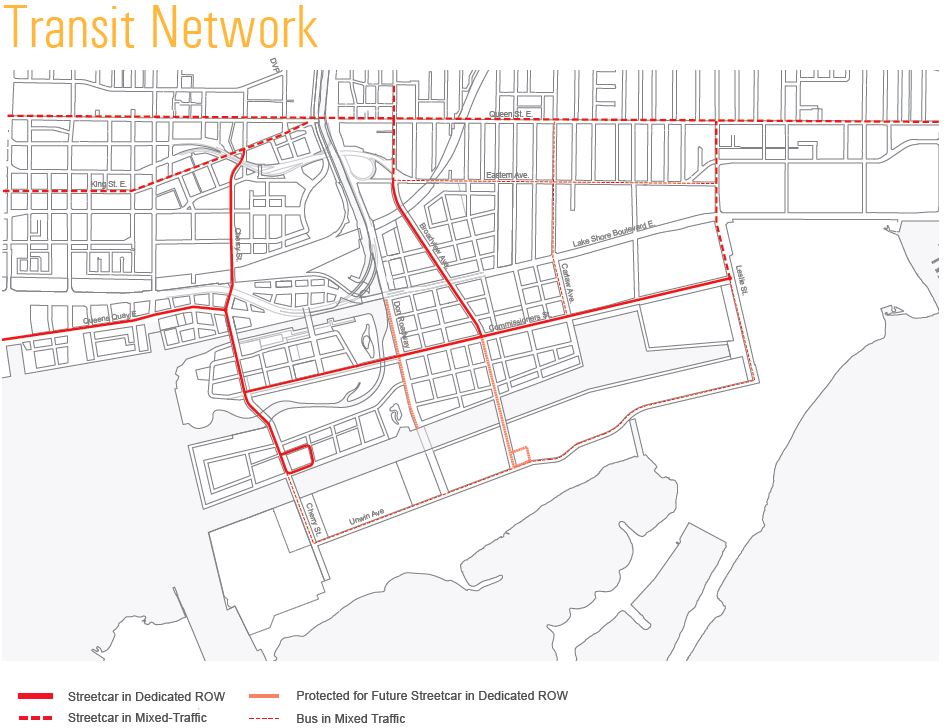
Note that this plan includes:
- Queens Quay East straightened across the top of Parliament Quay which is shortened from its current extent.
- Cherry Street passing under the rail corridor (through an expanded underpass) and realigned between Queens Quay and the new Don River outlet.
- Broadview Avenue extended southeast to Commissioners with a potential future link across the Ship Channel to Unwin Avenue just west of the Hearn Generating Station.
(Other transportation details are discussed later in the article.)
Planning for this area must take into account both existing land use and development proposals already in the pipeline.
The diagram below is a hybrid showing components that already exist in the study area with the new river alignment overlaid for reference. The development massing shown in the West Don Lands and Keating Precincts does not necessarily reflect what will be there, and a few pending changes are noticeably missing: the Gardiner remains in its current alignment along the Keating Channel, and only “Old Cherry Street” is shown although the space reserved for the “new” street is visible north of Keating Channel.

Several development applications are already in the works.

The single largest transformation beyond the reconfiguration of the Don River itself is the creation of Villiers Island.

This shows the island in plan view with its new street layout and the parkland that doubles as flooding area for the river. (A secondary spillway, shown in light green in the southeast corner, continues south to the Ship Channel.)
However, the map alone gives no sense of what could arise on these lands.

Almost none of the buildings shown in this illustration exist today. This view, looking southeast, shows the New Cherry Street with its dual road and streetcar bridges over the Keating Channel with the Cherry Street carline ending north of the Ship Channel.
This development, whatever form it takes, lies a decade in the future, but ten years is not very long in planning terms, let alone for construction of transit infrastructure. These lands are not in walking distance of any new station that might be built to serve the Unilever site, and they are far from Union Station. The ongoing foot-dragging by City Council, the TTC and Waterfront Toronto’s funding partners leaves a vital component of the waterfront’s redevelopment in limbo – its surface transit network.
Connecting the Port Lands to the existing city will require both substantial new transit infrastructure and a road system designed for smaller city blocks suitable for residential/commercial land use rather than the large blocks for industrial activity.

The mode splits for travel by transit are quite aggressive, and they will not be possible without good service and adequate capacity for the new development. If transit is not provided or does not attract the proportion of demand in these targets, the result will be instant road congestion because the new road network is designed around the premise that a large proportion of the trips will be by transit, cycling or walking.

New or revised connections between sections of the study area were examined in detail. Here I will present only the “preferred” options for each case, and readers can refer to the Transportation section of the consultation website for information about the alternatives that were examined.
The Unilever site and nearby lands today form a large, closed space that requires better north-south access. Note that the fan of rail sidings on Lake Shore south of the Unilever site will disappear as part of reconstruction of this neighbourhood as it is no longer required. This will open up a south entrance of the site.

Between Carlaw and Leslie, there is a long block without a through north-south access to Commissioners Street. This would be opened by extending Caroline Avenue south from Eastern.

Additional access is needed to the south side of the Ship Channel which can be reached today only via Leslie (and a narrow Bailey bridge) or Cherry. Alternatives reviewed included widening either of these two streets, or extending Broadview or the Don Roadway south over a new bridge at the channel. The preferred option is to extend Broadview. Any new bridge will be an expensive undertaking, and this option could face some opposition. However, it would bring a new road to Unwin Avenue just west of the abandoned Hearn Generating Station to serve whatever new use might be made of the site and buildings.

New east-west connections are also important for circulation and access in a much more dense neighbourhood than what exists today. One is needed through the Unilever site, and more are required between the realigned river and the Ship Channel.


All of this leads to a street plan with many more principal routes through the area. This will support not just auto/truck and transit movements, but also an extensive network of bike lanes.


Design of all of the major streets can take advantage of the tabula rasa situation in the Port Lands. Almost all roads are not constrained by immediately adjacent buildings, and the rights-of-way can be designed with enough room for many uses. This makes a “Complete Streets” approach to the design much simpler than on roads in the core where any space given to a new use such as cycling or wider sidewalks can only be obtained by taking space away from something else.

Here are a few examples of what streets might look like based on these principles. Many more are in the reports.


From the perspective of 2015 and a city that can’t seem to build anything, much less on such a grand scale, some of this may look like a wonderful dream we will never see. Political wrangling and economic upheavals over coming decades could spike the whole project, or trivialize the attempt to create new, integrated, well-designed neighbourhoods. We need only look at the central waterfront to see what happens when development runs madly ahead of any civic will or power to constrain builders to a good overall plan. New Queens Quay is beautiful, but imagine what might have happened if it had already been in place three decades ago and the waterfront developed around it at a scale the streets and transit could handle.
Queens Quay West is, at least, within moderate walking distance of existing transit lines, but the eastern waterfront is much different. We cannot afford a “transit last” mistake here where a few buses are seen as good enough to make do while transit fantasies elsewhere are showered with billions.
Will City Council engage with this plan, or tinker with it beyond recognition? Will partner governments at Queens Park and Ottawa recognize the value of what could be built here, a whole new city on the lake? Who will emerge as the Waterfront Champions?

Right next to our existing downtown, this is an essentially blank slate. And it is not being made car-free? That is complete insanity.
LikeLike
Although I do not think we should be worried about it being completely car free, the car should be very much a secondary mode of transportation for the area. The East Bayfront LRT needs to come first, before development. The car should be made to be very much in a supporting role, where transit, walking and cycling are all placed well ahead of it.
LikeLike
Thanks for the great article Steve, this may be one of my favorites yet. I’m assuming in the initial proposed track map (“End state transit network could look like…”), the coverage is made up of two lines, each with two branches? A 504 either via Queen or via Cherry / lower Broadview, and a Harbourfront east to either Leslie or short turn at cherry loop seems to make the most sense.
Steve: Various lines have been proposed including a service from Kingston Road to downtown via Leslie, Commissioners and Queens Quay. It’s too early to say which parts of this network will be built, let alone what the route structure might be.
It’s also interesting to see the proposed populations – the three “inner” areas of Lever Lands, Lower Don, and Film Studio all have a ~25-30k estimate, whereas the three “outer” areas of South of Eastern, East Port, and South of Ship Channel are closer to 5-10k.
With the Gardiner no longer expected to poke east of the Don, I was hoping to see a little more North – South connection between the Don and Leslie – I’m worried it will still be a wide, highly trafficked quasi-highway that will separate the northern and southern halves. It would be nice to see Logan cross Lakeshore as well near the Lever site, and maybe two connections between Carlaw, Leslie instead of just one.
Steve: Some of the large blocks cannot be broken up because of existing land use, notably studio space.
The final “planned roadmap” reflects both of the above in that it looks like the developers want close streets with taller buildings in Lever, Don, Film and more industrial blocks with less density in Eastern, Port, Ship Channel. I understand that the area has an industrial past but, echoing Kevin’s comment above, can we not take this blank slate next to the existing down town, and make the whole thing a “downtown east” instead of a mixed use development surrounded by industrial hang-ons?
Steve: The plan is less one of what developers want, but of what the City and Waterfront Toronto have put together as a workable multi-decade plan. Don’t forget that the Port Lands are not just about history, but are an active working port. You cannot wish this away by asking for a “blank slate”.
On that note, I do love how they’re trying to feature the Hearn – it’s such a cool building, and it would be nice to see it find new use instead of just getting torn down!
Steve: The biggest problem with the Hearn is access. The proposed Broadview extension across the Ship Channel “solves” this, but at a substantial cost for a new lift bridge. We could build a lot of other improvements in the waterfront for what that bridge is expected to cost. Definitely a long-term proposal as the port lands develop, not something that will happen in the next five to ten years.
LikeLike
Thank you for the summary, Steve.
I’m definitely pleased by the opportunity to create new neighbourhoods, complete streets and new local semi-rapid transit (and in ROW no less) in a tabula rasa.
Unfortunately…the crucial element of Transit First is obviously the transit…but the TTC cannot absorb the costs of placing transit before people are present in significant numbers in the area. They have already shown this on the East Bayfront (although the realignment of the 172 and the revival of the 121 is somewhat promising). Plus transit in ROW is wonderful but the capital costs are going to be something else…especially without the impetus of something like the Pan Am Games which gave us the Cherry ROW (but left us unsure about how to pay for…and when to introduce…a streetcar).
I’m glad to see there is an impressive vision for the Port Lands…the challenge now is making sure that it comes to life.
Cheers, Moaz
Steve: The Games did NOT give us the Cherry Street ROW. That was funded by Waterfront Toronto as part of the West Don Lands infrastructure. The effect of the Games was indirect through acceleration of development in the area, but that would be a pre-requisite for new transit service anyhow.
LikeLike
Agreeing with the other posts, this is an excellent article, and very very informative.
I hope to live long enough to see the fruition.
I am agreeing with Kevin’s basic gist, but also with Malcolm’s realism. The car ought to be relegated to the same place where buggy whips are. Still around, seldom seen.
I doubt if this would happen, but if residents and employees of the Portlands had no parking whatsoever, it would really set the tone, would it not?
Roads would allow taxis and delivery vehicles to do their chores. Residents would rely on public transit, walking and cycling, and when necessary, rental cars. Sounds quite civilised to me.
Myself, I need a flotilla of cars because there is no public transit where I live, way out in the “sticks”. There’s one car in the shop all the time. There is always another in the driveway that’s waiting its turn in the shop. Wow, I know what it feels like to run a fleet of buses. Don’t tell me to move; I love the quiet privacy here.
LikeLike