
Updated on December 12, 2013 at 5:40 pm: Maps of the original SLRT alignment proposed by the Transportation Plan Review and the alternate alignment proposed by me and Robert Wightman have been added at the end.
Original article from December 10, 2013:
Back when glaciers still plied the northern outskirts of Toronto, there was something called the Metropolitan Toronto Transportation Plan Review. It was an outgrowth of the decision to halt construction of the Spadina Expressway and take a new look at Toronto’s transportation plans. At the time, folks living in The Beach and the east side of downtown were fighting against the Scarborough Expressway. This project would have linked the (former) stub end of the Gardiner at the Don east to Woodbine, north to the rail corridor, and then east to link up with the 401 in eastern Scarborough.
The MTTPR (as it was called) looked at alternatives to the expressway and in March 1974, they came up with a scheme to build an LRT line with two branches. This would follow Queen Street (as part of the streetcar service) to east of Broadview, then follow the rail corridor to Scarborough Junction. One leg would head east to Morningside, while the other turned northeast to the Scarborough Town Centre.
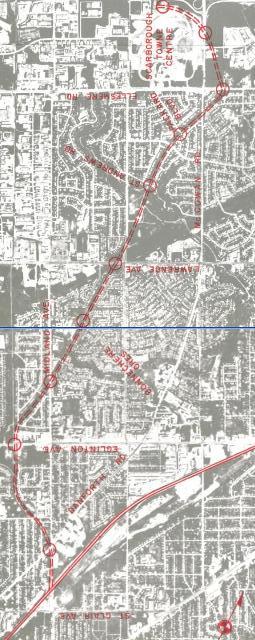
The proposed STC route followed the Uxbridge Subdivision north from St. Clair to just north of Eglinton. At that point, it turned along an abandoned rail corridor (the Orono Subdivision) that runs northeast eventually crossing McCowan south of Ellesmere where the line would swing back west into the northern part of the STC lands. This proposal brought howls of outrage from residents whose properties backed into the old corridor, and the MTTPR was looking for an alternate route.
Robert Wightman, a frequent contributor to comment threads here, and I wrote a critique of the MTTPR study. We observed:
Orono Subdivision Alignment
This alignment was chosen to maximize penetration of the residential areas between Eglinton and Ellesmere in the Northeast Corridor. Regardless of the desirability of such penetration, the residents of the area have repeatedly expressed their opposition to the use of the Orono alignment for a rapid transit facility. Even Go Urban, which supposedly minimizes neighbourhood impact, has met with strong opposition. The right-of-way is very narrow and, in places, forms part of the recreational area of the communities through which it passes. [Steve Munro & Robert Wightman, March 11, 1974]
“Go Urban” was the ill-fated, but provincially backed “maglev” system that would bring a network of silent, elevated trains to Toronto. When this scheme failed, Queen’s Park backed off to LRT for a time, but their heart wasn’t in it beyond building a new streetcar fleet for the TTC.
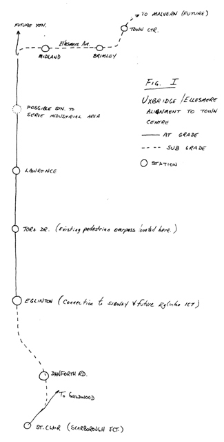
Wightman and I proposed, yes, the alignment we all know and love today as the SRT up the Uxbridge Sub. Unlike what was built, however, our version turned east in a tunnel under Ellesmere with stations at Midland and Brimley before swinging northeast into STC on an alignment aimed at a future Malvern extension. We were still ten years from the opening of the SRT, and the original plan called for LRT, not the new provincial technology that would evolve into ICTS or “Skytrain”.
In 1974, the Danforth subway ended at Warden, but the Kennedy extension was already on the books. Indeed, even when the SRT did open, there were remnants of the original LRT design including some signage (long gone) and clearance markings on the low level platform and, of course, the loop (still in place). There was also talk of an Eglinton ICTS “intermediate capacity” line running west from Kennedy Station. Such a line is only now under construction four decades later.
We ended our report with concern about how well LRT would be accepted as a new transit mode:
We recognize the position of the M.T.T.P.R. in avoiding the role of “salesman” for Light Rapid Transit or any other transit mode. However, we question whether the concept has been adequately introduced and explained to both the decision makers and general public in the Scarborough Expressway Planning Review […] . There has been little effort on the part of the Plan Review, the Toronto Transit Commission, the Metropolitan Toronto Government or the Provincial Government to cultivate a general awareness of the nature and capabilities of this transit mode. We question whether the Plan Review, in avoiding the “political” role of salesman for Light Rapid Transit, has abdicated its important purpose of informing the public on transit alternatives in transportation planning.
We recommend that the Plan Review, through its public participation program, undertake to educate the public on Light Rapid Transit so that they can intelligently assess the proposed alternatives to the Scarborough Expressway. [ibid]
Needless to say this did not happen, and the MTTPR’s head, Richard Soberman, went on to become the salesman who would bring ICTS to Scarborough at the behest of the provincial government. He even joked about this during his review a few years back of options for replacement of the aging SRT, with the clear implication that Scarborough Council were like carnival “marks” ripe for the picking with promises of a showcase for Ontario’s new technology. There was also very substantial arm twisting from Queen’s Park with threats of subsidy cutoffs if ICTS was not used by the TTC.
LRT didn’t have a chance, and Toronto has suffered ever since from the absence of that “missing link” between subways, buses and streetcars.
Maps of the Alternatives
The first map shows the LRT line following the Uxbridge Sub from Scarborough Junction north and slightly to the west to Kennedy & Eglinton. A short distance to the north, it enters the abandoned Orono Sub right-of-way and follows this to Ellesmere east of McCowan. Then the line swings west again into the north side of STC. This version could only be extended to Malvern by a branch that would continue on the Orono Sub north from Ellesmere and would not give direct Malvern to STC service. (This map was drawn in landscape with oddly oriented titles, and it has been rotated to portrait format to allow easy comparison between the schemes.)
The second map is a sketch using the same alignment to Eglinton, then continuing north to Ellesmere, east to beyond Brimley, and then into STC from the southwest. Note the provision for extensions.

This is yet another one of the long list of bizarre transit plans that fortunately was never built. Why would anyone want to run LRT along the Lakeshore East line? If you are running along a GO train line you use electrified GO trains. Had we actually invested in proper GO train service in those days, using standard electrified rolling stock not something unusual like ICTS, then my guess is the SRT would have simply been a branch of the GO train network.
Now we have the proposal to replace the SRT with a costly subway extension, which I don’t think makes much sense. Not that the rather strange proposal to make the SRT part of the Sheppard LRT makes any sense either; somehow I wonder if you could convert the SRT to use the same electrified GO rolling stock an expanded Stouffville line uses, although you might not be able to run all the trains to Union due to lack of track capacity.
Steve: Don’t count on an expanded Stouffville line any day soon. The SRT was not to be “part of” the Sheppard LRT, merely to share the carhouse. “SLRT” trains would run from Kennedy Station to Sheppard on their own right-of-way, with a future extension northeast to Malvern. A single connection track would link the SLRT to Sheppard for carhouse moves.
I agree that the idea of duplicating GO was far-fetched, but it shows an early version of how GO simply could not be counted on as part of the “Toronto” network rather than as a service for people from outside what was then “Metro”.
LikeLike
I agree that the case has yet to be made for LRT in the Toronto region, and I think that LRT could potentially be a transformative link between the GO rapid rail network and the subway system replacing to some extent the role of buses, allowing both to do their particular jobs much better.
The work of designing and evaluating and showcasing a role for LRT still needs to be done. But by who? And how best to do it? The current ‘transit debate’ in the region is shallow, plagued by misinformation, and getting worse with each intervention by our Mayor, and the politicization of individual transit investments.
But arriving at good transit planning debate is harder. The mass media is not so great at examining the details and nuances that make a big difference in transit strategies. Environmental assessments only evaluate the already selected investments and ask whether there are alternatives. Academics have zero or less incentives to engage in examining hypothetical scenarios that are unlikely to go forward. The blogosphere has a million sincere advocates whose opinions are reliably contradictory.
Who exactly could meaningfully promote LRT, and how would that best be done?
Steve: I am not entirely sure, but it won’t happen when we are less than a year from two elections in which transit will be a major issue.
LikeLike
I’m sorry Andre, but IMHO the blame lies with the electorate (in particular Ford Nation) and not the TTC, academics, or bloggers. The info about LRT has been out for years and years, the TTC had several information sessions and open houses about Transit City, you can look up what LRT is and how it works on the ‘Net at Wikipedia and the above-mentioned blogs-and yet nobody gets it or can do the research before making a decision about going ahead with it?
It seems to me that the average person only cares about surfing porn, reading gossip, blabbering away about the latest TV show/sport/, and playing games when they’re on the ‘Net rather than find out about something important that will affect them locally and in later years to come. If that’s not the definition of the word ‘sheeple’ then I don’t know what is.
LikeLike
@Neville .. I am no Ford lover either, but why do you all blame this supposed “Ford Nation”?
How do you explain the last 30+ years when there was no Ford to blame and still we got RT instead of LRT, and little else except a few one-station extensions and some new bus routes here and there.
Are you saying the electorate was always to blame?
Steve: The RT was forced on the TTC by Queen’s Park as a showcase for their new technology at over double the cost of the LRT line originally proposed. The biggest problem over the years has been that the planning and construction cycle is somewhat longer than the political cycle, and every major change in the “flavour” of governments at the local and provincial level brought new policies. Add to that a funding scheme that forced a “one line at a time” outlook, and we spent more time fighting about whose line would be next than planning a network.
LikeLike
At that time GO Transit was in its infancy, and there was a huge government push to be at the forefront of new technologies, hence the maglev (GO Urban) and later the ICTS (SRT and GO ALRT). Instead of investing in proven, reliable (and lower cost) railway technology available ‘off the shelf’ they wanted to be ‘first to market’ with new technology.
CN and CP weren’t too happy with electrification then and I’m sure they aren’t too happy with the idea now … but at least we’ve gotten past the idea of needing a ‘made in Ontario’ technology to push transit.
Cheers, Moaz
LikeLike
I think the only way that LRT will be popular again is the implementation of the transit city bus plan (especially the new and increased express service).
The transit city bus plan is the first step as it will build the local and regional travel patterns that will justify LRTs. I think the biggest failing with transit city is that we did not build the behaviour from transit riders for limited stops (which will happen with LRTs) and we do not have a good model if limited stops make sense on that road. Out of the three lines chosen to be built first, only Sheppard East actually has limited stop service (190 rocket) that we can reasonably model and say that LRT meets a current and future demand. We can only make a best guess as to if limited stop will work well for Finch West and Eglinton crosstown given that it was simulated and not actually trialed. The transit city bus plan, which called for express service for LRT lines not being built would help us sort out if the line truly needed LRVs. After all, it would be a waste of money for LRTs if the demand for limited stop service was only there for the rush and not anytime else (e.g. Jane, Eglinton East of Kennedy).
Steve: Actually, the TCBP explicitly did not include express buses on the LRT routes because the TTC feared that the imminent construction would make it impossible to run a credible express service.
LikeLike
Moaz Yusuf Ahmad wrote:
Have we? Can you say ‘Presto’?
LikeLike
Many European LRT lines operate at high average speed and provide high ridership despite being in the middle of the road.
The Grand Boulevard trams in Hungary, lines 4 and 6, are run with 54 m long cars every 3 minutes or better in a right of way in the street. These cars hold over 300 people each on headways of 3 minutes or better. They carry over 200 000 passengers per day and run at a high relative speed.
The line in Nice carries 90 000 passengers per day with long trams, originally 5 sections but being increased to 7 sections. this line runs in a right of way most of the time but on some very narrow streets and some very very wide ones.
In most cities in Europe the painting of a solid white line and painting in the word “tram” on the road keeps automobiles out of the lane, must be a force field. However pedestrians and bicycles can often be found on transit rights of way and in some short tunnels, especially in Lyon. Just don’t try to photograph them, strictly forbidden without prior permission.
If we could only get one decent line built then opinion would start to swing, at least among the riders.
LikeLike
I was thinking of train vehicle technology….but yeah…
Cheers, Moaz
LikeLike
I am just curious, is there a map of this “Orono” alignment?
You just got me curious and I need to see things visually on maps to understand them properly.
Cheers!
Steve: Now added.
LikeLike
That first map had my eyes going all screwy even after I found the “North” arrow. It looks by the street lettering that it was designed to be read upside down and is also currently turned 90 degrees from that. So strange. Do you mind rotating it to the same orientation as your sketch and perhaps arranging the two images side-by-side?
Steve: Done
LikeLike
The same suburban LRT route becoming streetcars as they reach downtown?
Is the rail corridor just east of Saulter Street the one you’re talking about? How would Queen Street and this rail corridor have been linked?
Steve: Yes, it was rather far-fetched, and we recommended that this part of the idea be dropped. It was. There were few details in the report, but this would have required some sort of ramp structure whether the LRT ran in a tunnel under the rail corridor, or on new tracks beside it. The study did not go into complex engineering details.
LikeLike
The only way Torontonians will get to learn about LRT is for some brave politicians to just ram one through so people can see and ride it. Transit City was first announced in 2008 and we’re still a few years away from seeing anything. That gives the Rob Fords time to spread their lies. The Eglinton line is complicated by all that tunnelling. I would try to have the Finch LRT running the day the Spadina extension opens. It’s the simplest. It should even take precedence even over the Downtown Relief Line since it could be built much faster and maybe could be running by the time work starts on the relief line.
LikeLike
If only an “LRT Training Centre” had been built on the Queensway between Parkside Drive and the Humber loop.
Until then the closest example is Buffalo’s high – floor LRT. It may not be new but it does run along Main St both above ground and underground and the above ground part (on the Main Street transit mall) is free to board.
Buffalo’s LRT demonstrates the advantages that LRT is supposed to have … class A right of way (the above ground section is being converted to Class B), flexibility to run in trains, ability to run in cold winters with snow & winds … all the things Toronto needs to know.
Ironically the Toronto Star sent a few reporters to Buffalo (their reports were in Tuesday’s Star) to talk about different aspects of Buffalo’s downtown resurgence. Christopher Hume even wrote a column in Buffalo’s architecture … but there was no feature on the LRT.
Cheers, Moaz
LikeLike
Steve’s reply to Pete nicely summarizes many issues in a compact space. The issues of planning cycles and network planning are problems in other cities as well as Toronto.
The Scarborough RT should have been either a subway extension, or a busway. Either option would have allowed a single transfer from feeder bus routes to the subway. The use of any other technology, including LRT and the SRT we actually got, automatically constrains its usefulness (and hence ridership) by imposing the second transfer a few stations after the first transfer. It might have been a different story if the SRT had been part of a longer regional line such as the Eglinton LRT currently under construction, but it wasn’t. The province got their showcase, at the expense of poor rapid transit in Scarborough for generations.
The idea of running a Scarborough LRT onto existing streetcar tracks on Queen (or any other) Street is ludicrous. The long stop-and-go section leading into downtown would kill the effectiveness of the line for long-distance travellers from Scarborough. If the Scarbrough LRT became the Queen subway (known as the Downtown Relief Line today) it would be a different story, but of course that remains a pipe dream as well.
The Spadina Expressway/Subway is one very clear example that the best location for a highway (if such a thing is possible) is not necessary the best location for a subway. The Spadina Subway is basically a relief line for the Yonge Subway. For the most part it simply intercepts bus passengers 5-10 minutes before they reach Yonge, while not serving much else of significance (Yorkdale excepted) and leaving large parts of the city a very long bus ride away from a rapid transit line. I haven’t looked at the finer details of the Scarborough situation above but it appears that killing the Scarbrough Expressway may have imparted some similar influences upon the proposed locations of rapid transit in that corridor as well. BTW, local politicians were all in favour of the Scarborough Expressway in the 1950s and 60s because they saw it as a way for their residents (voters) to get to downtown. What killed it in later decades was that it was viewed as a way for *other* people from further out (Pickering etc.) to go *through* their community to downtown. Big difference.
While we’re on acronyms and proposals, another one from the early 1980s was “GO-ALRT” (GO as in regional, and ALRT = Advance Light Rapid Transit), using the ICTS (Scarborough RT) technology. It was a visionary regional plan at the time — too bad that nothing much ever came of it. The major line in the network would have connected most of the major suburban development nodes of the day: from Pickering (GO Train interface) via Scarborough Town Centre, North York City Centre (probably Yonge/Sheppard — I’ve forgotten exactly), the airport, Square One in Mississauga, and terminating with a GO Train connection at Oakville. Of course today there is a new ring of outer suburbs along Highway 407 and beyond in addition to this inner ring. Ironically, one of the few sections that did get built was some regrading and bridge expansion along the GO Train corridor between Pickering and Oshawa which became GO-owned conventional tracks (versus CN for the rest of the Lakeshore line) — in the area where GO least needed to have dedicated tracks. Sigh.
For the next 30 years after GO-ALRT I sighed as the TTC expansion plans didn’t even connect the two legs of the Y-U-S horseshoe: a line east from Yonge/Sheppard and a line west from Eglinton West, with no rapid transit connection between the legs of the horseshoe north of Bloor! (You might count the rebuilt St. Clair streetcar today.) Even the new Eglinton line under construction is much too far south to be useful for suburb-to-suburb commuting within northern Toronto (eg. North York), never mind people outside Toronto.
LikeLike
This goes to a previous comment that Steve made with regards to planning a network, not fighting over “getting my line”. This also goes against the idea of using subway extensively, as it means too many areas never getting high quality service in order to build too little cobbled to the same few lines. People complain about downtown being treated like the centre of the universe, however, the push to connect using an extension of Yonge, Bloor or the Danforth lines, basically means that in terms of the transit picture yes it will be, as you are pushing more load through a single channel, and increasing the connectivity to that area. North York and Etobicoke need connection to the airport and each other that do not flow through downtown. However building those subway extensions sucks up all the money that could be used for a more complex and flexible network.
LikeLike